We were very happy when the local mountains got about a foot of snow from our Christmas Day Storm, a few days ago, but apparently Mother Nature wasn’t quite done delivering the goods for the holiday week. We just had another storm drop similar amounts of snow thanks to upslope conditions on the back side. The storm was actually rather warm, and it cut right through Northern New England such that mixed precipitation was expected in the middle of the event, leaving us unsure if it would be a big net gain for the slopes. Fortunately the slopes did get quite a net gain in liquid equivalent, with snow on the front and back ends, and only modest amounts of rain or mixed precipitation in the middle.
I followed the storm down at the house, and it began yesterday with a front end shot of snow that gradually mixed with sleet and went to a bit of rain overnight. The morning, the back side of the storm came through with plenty of snow. With all this snow I decided it was a good idea to get roofing Lakewood CO and other areas services to ensure that no structural damage had occurred to our house during the storm. It started up in the morning, and then pounded the mountains and mountain valleys today with snow falling at a rate of 1 to 2 inches per hour. In the end we wound up with 9.7 inches of total snow at the house, and the local mountains topped out at around a foot of snow. Below is the list I’ve seen for storm totals for the Vermont ski areas using their 48-hr snow totals. The list is from north to south along the spine of the Greens:
Jay Peak: 8″
Smuggler’s Notch: 12″
Stowe: 8″
Bolton Valley: 11″
Mad River Glen: 8″
Sugarbush: 12″
Middlebury: 6″
Pico: 10″
Killington: 10″
Okemo: 4″
Bromley: 0″
Magic Mountain: T
Stratton: 1″
Mount Snow: 0″
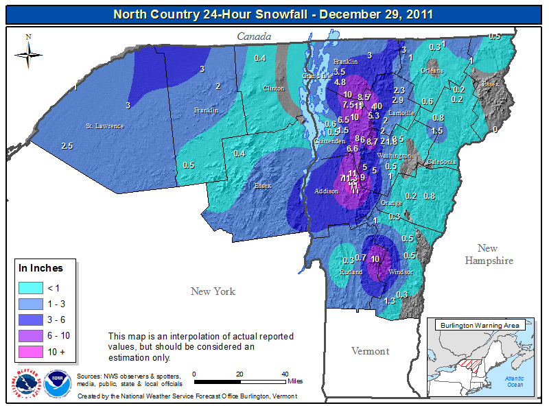
While last time around with the Christmas Day Storm, the Stowe area was the sweet spot for accumulations, this time around the east side of Addison County seemed to do the best with some locales topping the one foot mark for snowfall as indicated in the map of snowfall totals from the National Weather Service Office in Burlington:

For the full details on this storm, head to the detailed report at the winter weather section of our website.

One Reply to “Another storm for the holiday week, another foot of snow for the northern mountains”
Comments are closed.