Stowe, VT 24MAR2013

An image of Ken jumping off a rock on skis into the powder above Green Acres at Stowe Mountain Resort in Vermont
Ken tests out the powder landings above Green Acres.

I made a Bruce Trail reconnaissance run back in January, and since then we’ve been waiting for the right combination of snowpack, weather, and coach availability to bring our BJAMS group for a trip down the Bruce.  A couple weeks ago, the forecast began to suggest that the snowpack was just going to continue to build through March, so we decided to bide our time.  Indeed as the forecast suggested, this “powder week”, with between 30 and 50 inches of snow at the Northern Vermont resorts along the Green Mountain spine, has bolstered base depths.  One result of all that snow has been the growth of the snowpack at the Mt. Mansfield Stake; it’s finally crept above average this week, reaching a depth of 82 inches as of yesterday.  With excellent snowpack now all the way down to the mountain valleys, a forecast for partly cloudy skies with temperatures around 30 F, and good availability of the BJAMS ski program coaches that wanted to ski the Bruce… today was the day for our trip.

“All in all that had
to be just about
perfect conditions
today for skiing
the Bruce…”

We had a little time before our group got together, so we did a warm up run on Sunny Spruce with Connor and his dad.  As expected, the snow quality was excellent – it was packed powder on the trails and powder off piste, with just a few bare spots here and there on steeper south-facing terrain like Freddie’s Chute.  One of the highlights of that run was West Slope, where we rode the ridge along the skier’s left with big swooping drops into the chowder on the left side.  At one point I heard Luke screaming out behind me something like “That was so intense!” after launching a huge drop on one of his turns… intense indeed!

An image taken in the Spruce Peak Village area at Stowe Mountain Ski Resort in Vermont
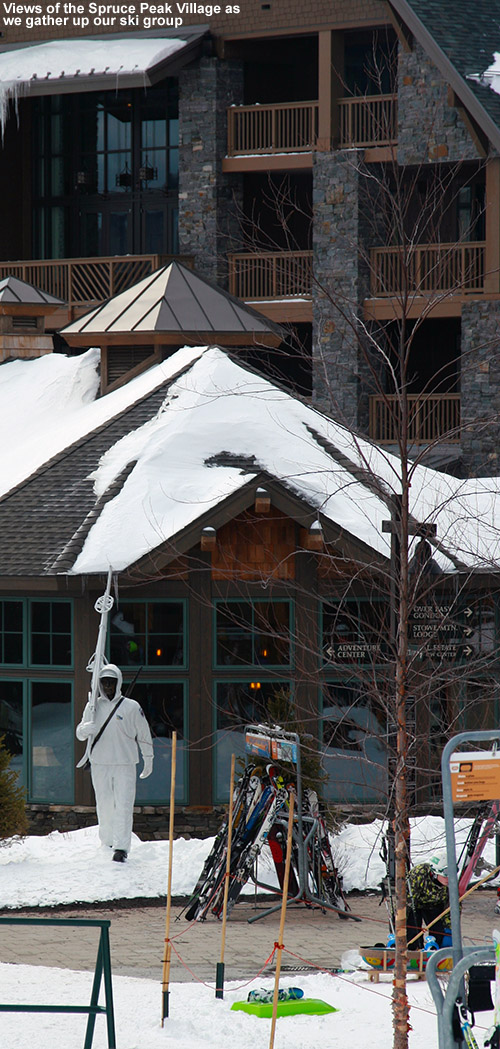
We gathered up our group, which featured Claire, Ken, Julia, Luke, Ty, Dylan, and me.  Along with Joana and big Luke, we were missing Joe, Sam and Ethan today, and I suspect they would have loved to make a run down the Bruce, but hopefully they’ll get to do it next time.  Apparently Joe did have a great day out on the mountain on Friday with Ken though, so he’s had a good dose of all this new snow.  We debated briefly about whether we should do our Bruce run at the beginning of the day or the end of the day, but with some folks having obligations preventing them from lingering at the mountain too long at the end, we decided that we’d better start with the Bruce and fill extra time in with some other runs at the end of the day.  Based on my reconnaissance day, I was going with a fairly conservative estimate of two hours for us to complete the run to the base of the Bruce.  I knew there wouldn’t be any problems for anyone in terms of the skiing, I was just unsure about what our pace would be through the flatter terrain in the Nordic areas.  If the kids found it tiring it might take longer than what I’d experience on my own, so I figured it was better to be safe than sorry.

An image of Ty skiing powder at the top of the Bruce Trail at Stowe Mountain Resort in Vermont
Dropping into the Bruce Trail for an afternoon run
An image of Luke, Julia, and Dylan making their way down the Bruce backcountry ski trail near Stowe Mountain Resort in Vermont
Luke, Julia, and Dylan make their way down a narrow section of the Bruce Trail.

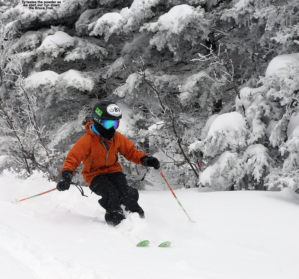
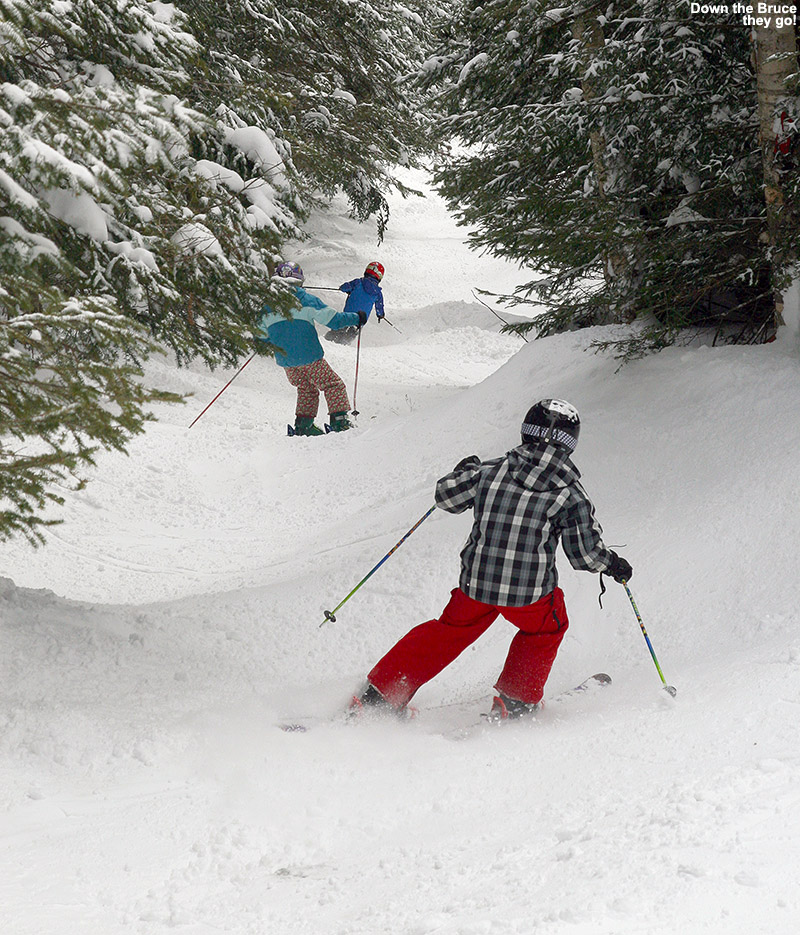
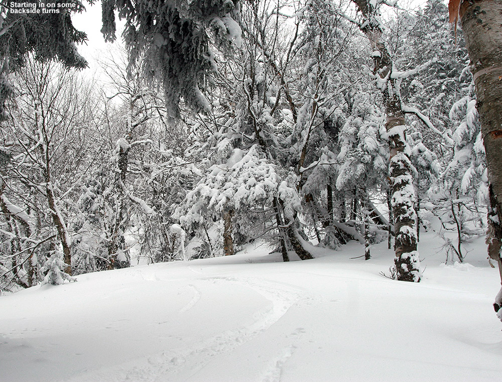
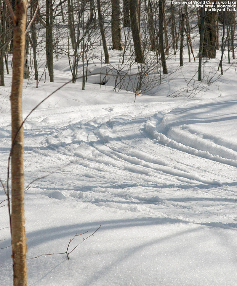
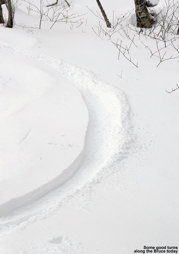
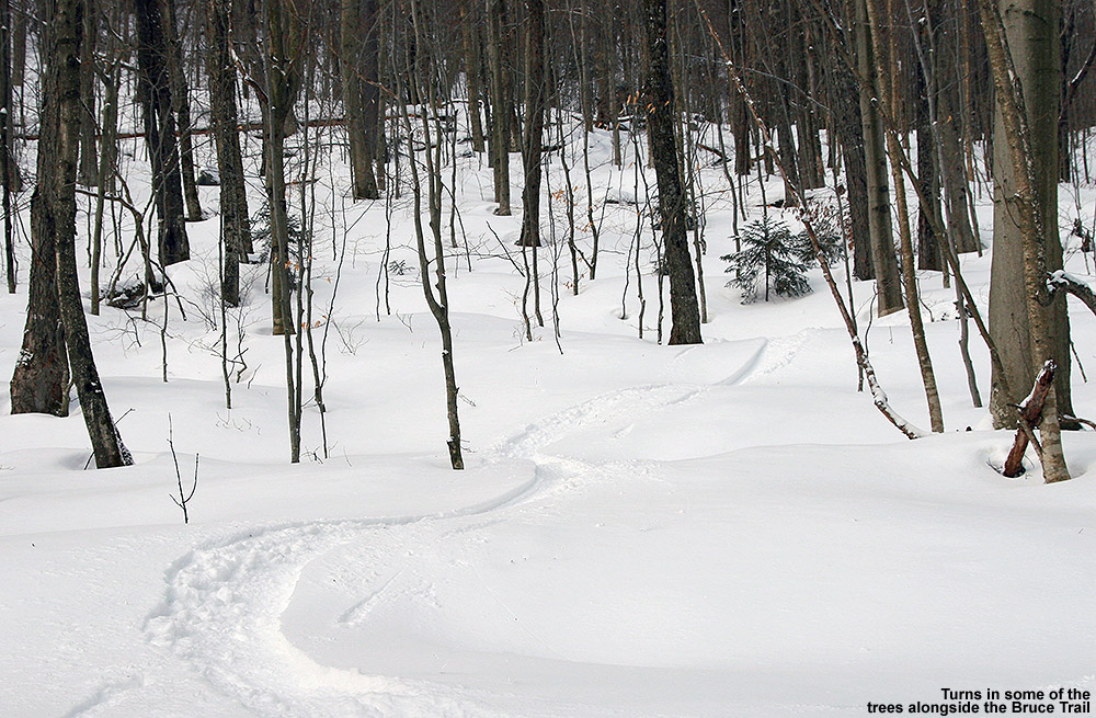
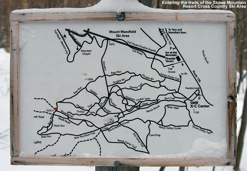
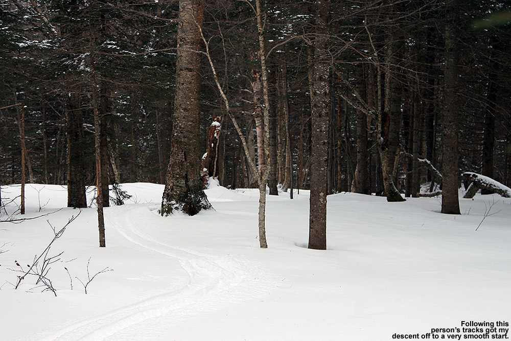
We didn’t waste any time getting to the top of the Bruce, we crossed on the Over Easy and went right up the Fourrunner Quad.  Unlike down in the base elevations, there was a brisk wind up there around 3,600’.  Some of the boys dropped in the alternate entrance to the Bruce for a bit of powder and I grabbed a few pictures there and some more as they dropped below me on the trail.  It was packed snow on the trail, but the quality was excellent, far better than what I’d experienced on my January trip, which was after a thaw the previous week.  The skiing in the upper sections went pretty much as expected, the boys were having a blast with the bumps and jumps, and one could explore the powder off to the sides when areas opened up in the trees.  A few of the steepest pitches were a little scraped down in spots, but that was pretty minimal because of the deep base and recent snow.  As we got down into the hardwoods and the forest began to open up even more, I started venturing father off the trail into powder lines based on my previous knowledge.  The powder was generally a foot plus in most places, and that worked well on most pitches – enough to slow you down on the steeper stuff, but not bog you down too much in the mellower areas.  Down on the Nordic trails, the final, flatter part of the descent went very smoothly.  Ty noticed one of those wavy green lines one of the trail signs, indicating beginner Nordic terrain, and with regard to the perceived flatness he said, “Oh no, that type of sign is never good!”  I’d say he found out that it really wasn’t that bad.  The kids did a nice job of keeping their pace on the flatter areas, and I’d give Ty and Dylan occasional boosts to keep their pace up.  They started to play around and get tangled up with each other as they skated and poled their way down the trail, so that kept them entertained even on the flats.  As a bonus we got those beautiful views of the snowy Ranch Brook, and the snow stayed quite powdery all the way down to 1,000’. All in all that had to be just about perfect conditions today for skiing the Bruce, comfortable temperatures, partly cloudy skies, and dry snow all the way to the base.  I’m not sure what more one could ask for aside from getting first tracks!

An image of skiers riding the Mountain Road Shuttle Bus in Stowe
Riding the Mountain Road Shuttle – it’s almost worth doing the Bruce Trail just for that!

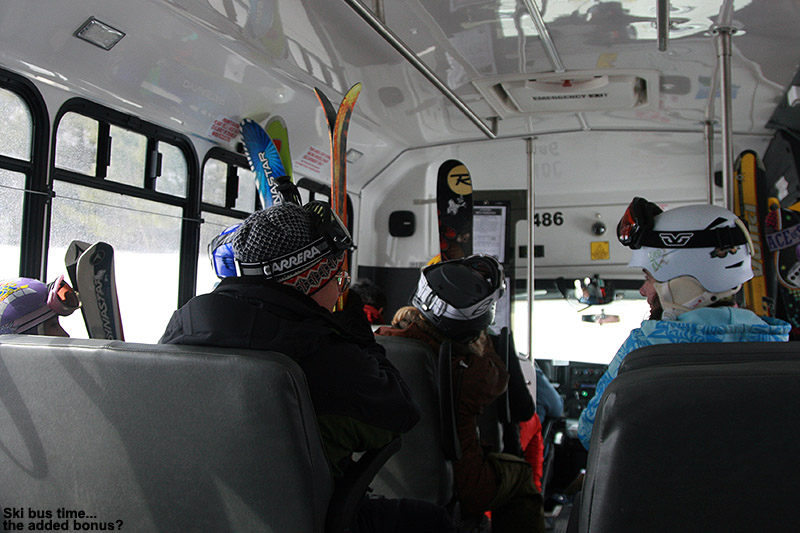
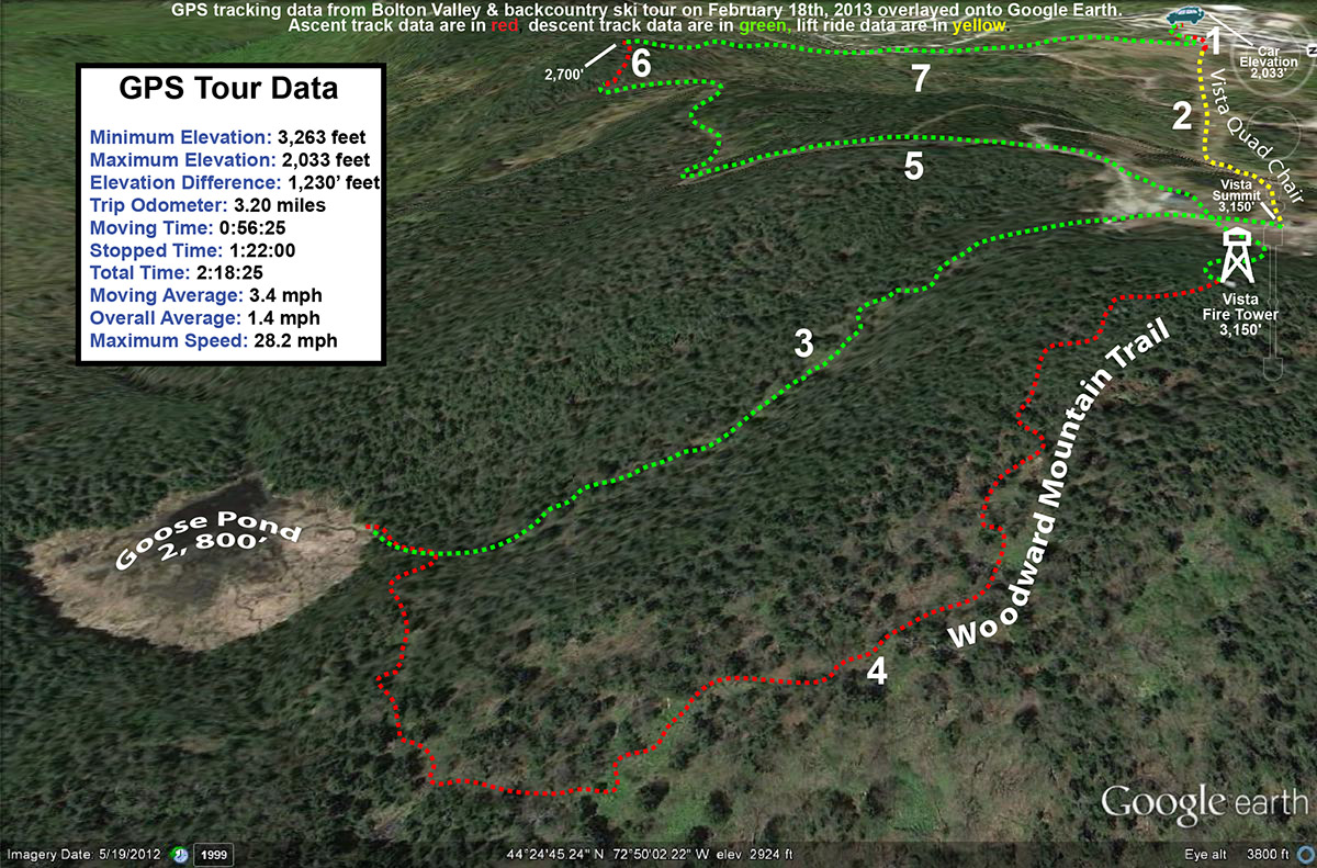
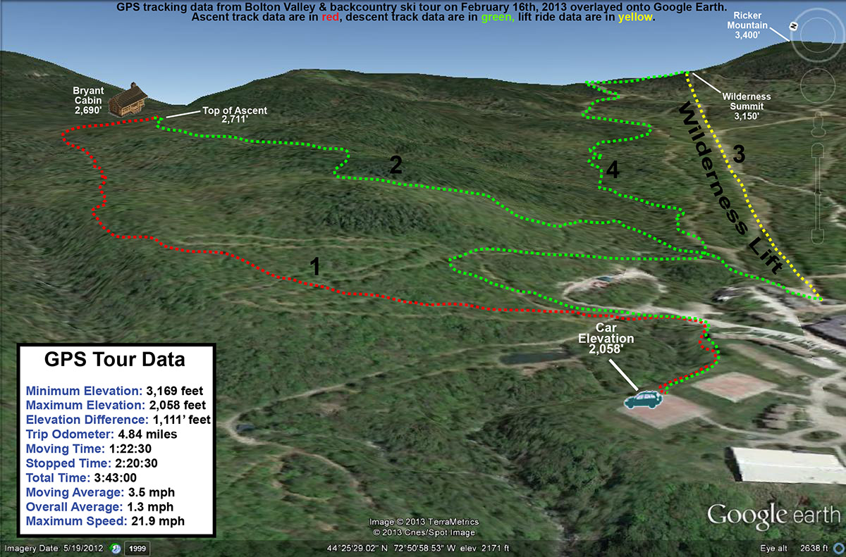
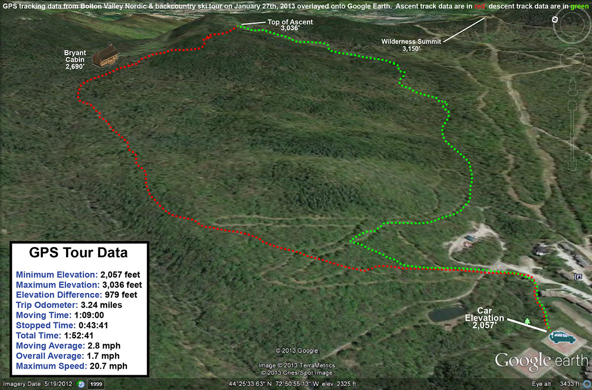
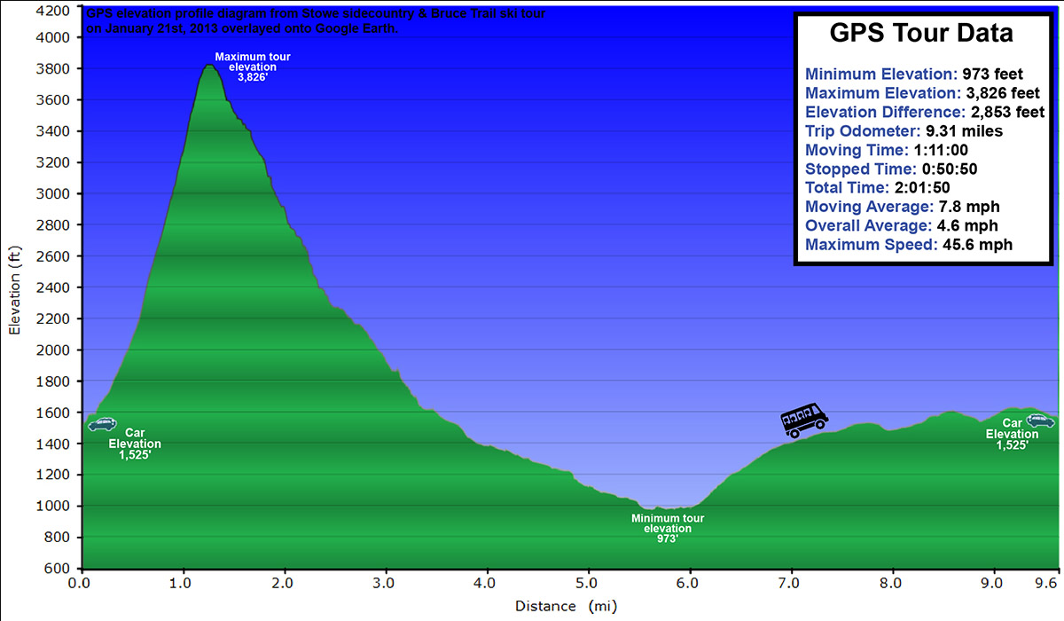
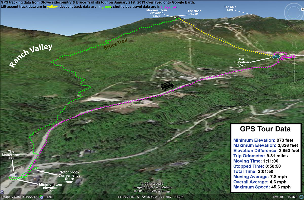
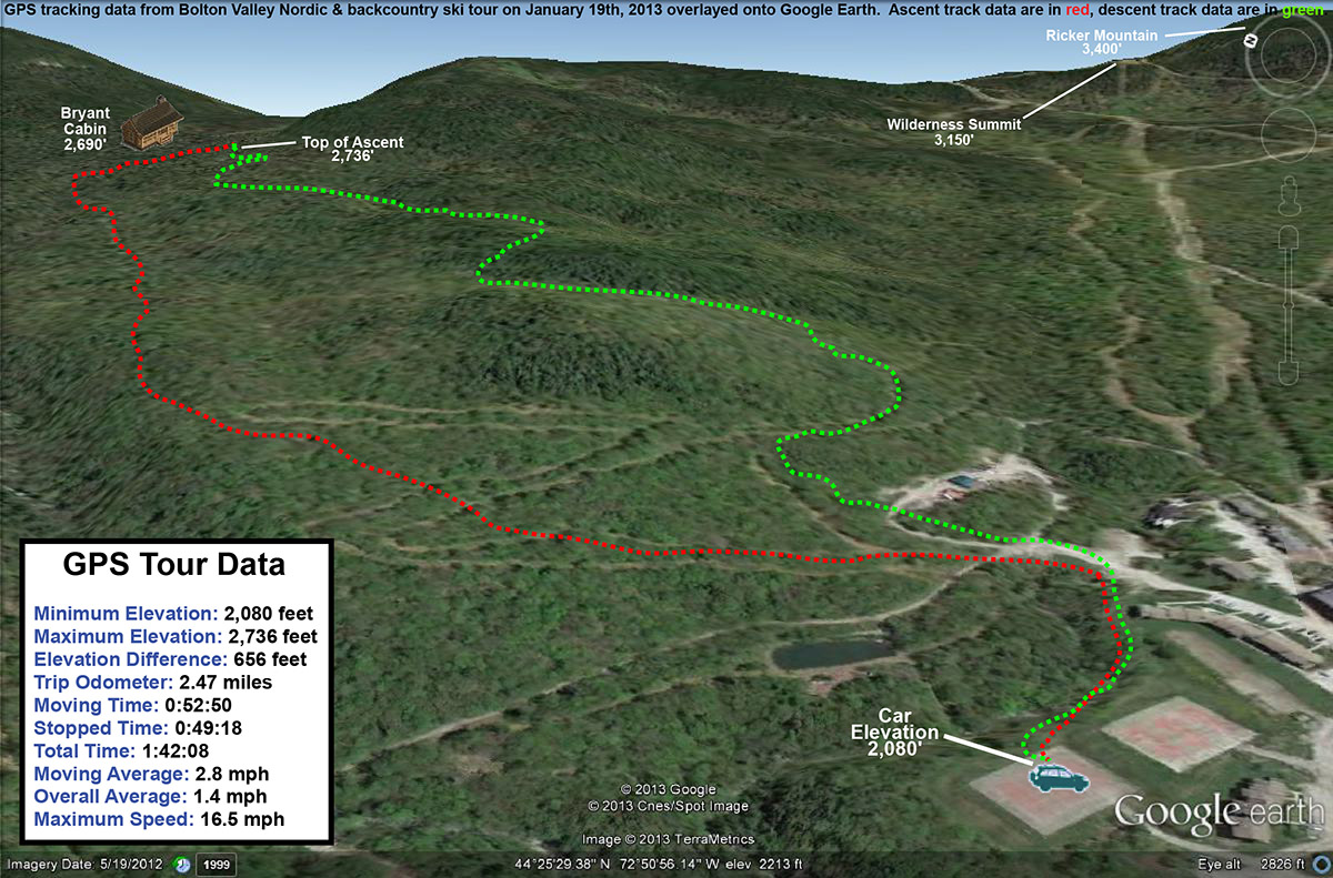
From leaving the Spruce Peak Base to reaching the bottom of the Bruce at Route 108, it had taken a bit under 90 minutes, so we made it well under my two-hour conservative estimate, even with the large group.  We were about 20 minutes ahead of the next Mountain Road Shuttle when we reached the end of the trail, so we popped into Notchbrook Convenience Store for some snacks, and enjoyed the early spring weather while we waited.  The March sun is quite nice right now, and it’s the beautiful sort of weather that is keeping the snow dry instead of sticky, even with relatively warm air.  Ty and Dylan loved the ride on the shuttle, and Ty only half jokingly insisted that “The Bruce was nice, but it’s the bus ride that’s really my favorite part of the trip.”  He certainly does like to ride buses.  For a representative GPS/Google Earth map or elevation profile plot of the travel circuit we used to ski the Bruce Trail, refer to my Bruce Trail trip report from January 21st.

An image of Luke completing a jump turn at the top of the Green Acres area at Stowe Mountain Ski Resort in Vermont
Luke comes out of a jump turn in the Green Acres area.

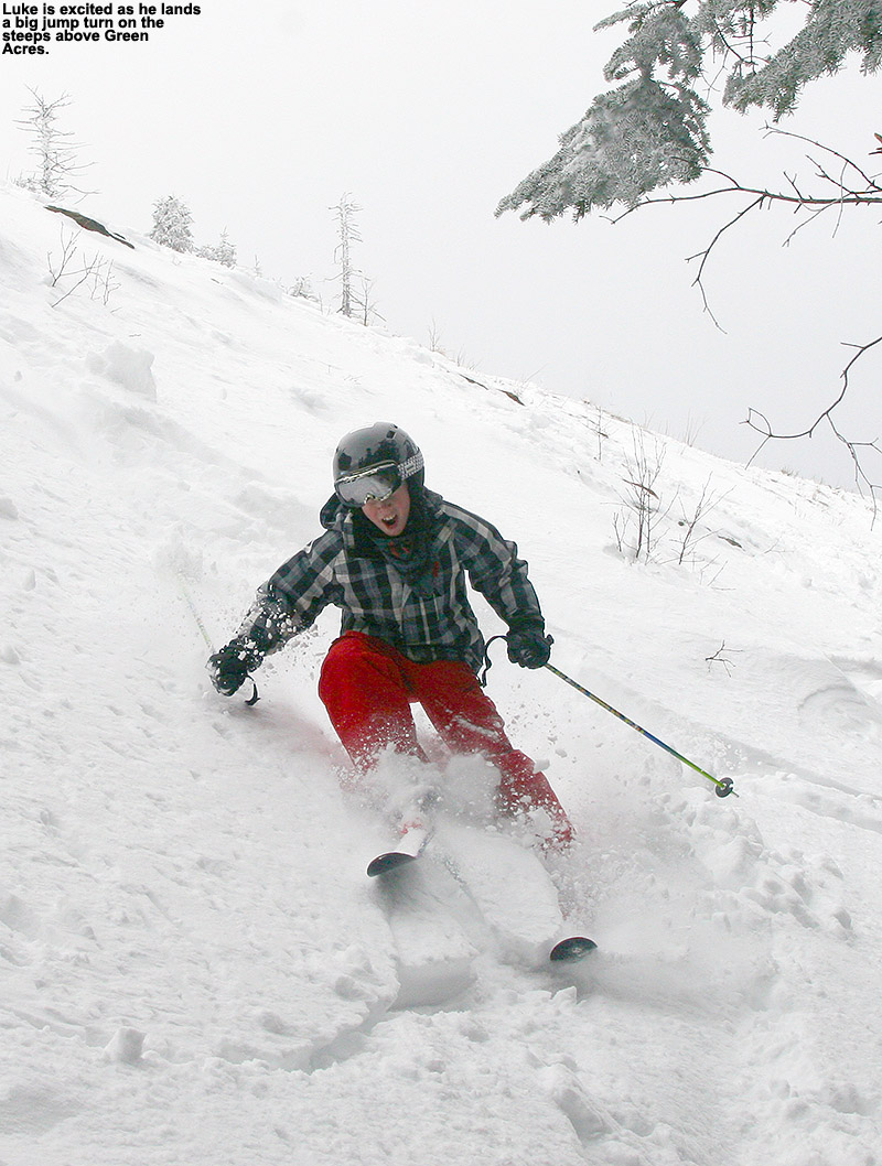
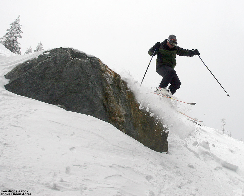
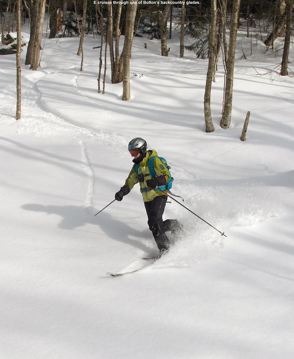
When we arrived back at the Spruce Peak Base Area, we had another hour or so before the lifts stopped running, and we decided to use our remaining time for a trip over to the Sensation Quad.  With the relatively deep March snowpack, it seemed like a good time to ski as much of Spruce Line as we could.  The strengthening sun is only going to start beating on that south-facing terrain more and more.  I was surprised to find that the steep terrain above Green Acres was fairly wind scoured, but we found a line through and the boys did some great steep turns and jumps off one of the rocks there.  Dylan led the charge with an impressive jump turn off the rock, landing in a sea of deep powder.  He was followed up by the other boys, including Luke who was totally jazzed at how high he went.  That steep pitch used to intimidate him, and now he’s launching huge jump turns off boulders into powder.  It’s great to see him expanding his skiing literally by leaps and bounds.  Ken launched a beautiful air off the rock as well, although he had to deal with sloppy fourth or fifths in terms of the powder on the landing.  The snow in Green Acres was excellent – powder of well over a foot in depth, which was plenty to slow you down in some of those tighter tree lines.  We couldn’t ski all of Spruce Line because parts were closed, but we did get the middle section that was fairly lightly tracked with some beautiful snow.  The group also enjoyed the chance to ski Main Street since there weren’t any races taking place – having Main Street open up for general traffic is one of those great things about approaching the spring season at Stowe.

“The Bruce was nice,
but it’s the bus ride
that’s really my
favorite part of
the trip.”

While most of the group had to leave a bit early, Ty, Dylan, and I found time to squeeze in one more run on Sunny Spruce.  We dropped into Freddie’s Chute, and Dylan worked his way to the woods on the skier’s right for some powder.  He ended making an impressive drop off a log, which had to be 8 to 10 feet high.  He did manage to hit his chin with his knee on the landing, and it wasn’t of any consequence, but I did stress the point of being aware that that can happen and making sure that your tongue is not anywhere near your teeth.  That was really an aggressive drop that he made, and between Bolton yesterday and Stowe today, he’s really been on fire with the airs this weekend.  With deep bases and deep powder though, ‘tis the season for such things.  We followed that up with some exploration of the trees off to the skier’s left of Lower Smuggler’s – a section that none of us have ever explored before.  We found some good lines, with just a bit of a slow exit on flat terrain.  We finished off with a final descent down West Slope, making use of that ridge and flying off the edge into the powder.

I just checked the forecast, and we’ve apparent got more snow on the way this week.  Nothing too big is expected, but the mountains often seem to do a lot with just a little moisture in the forecast.  Indeed this is turning out to be quite a March for skiing in the Northern Greens as we make up for the rather paltry snowfall of January and February.

Bolton Valley and Backcountry, VT 09MAR2013

An image of Ty Telemark skiing in powder of the back side of  Bolton Valley Resort
Heading up in elevation today to find that powder

Josh has been waiting for a while to get that perfectly clear day to finish up some media work at Bolton Valley, and today it finally came.  With the anticipated forecast, he set up for a 7:30 A.M. meeting today in his office, with the plan to catch an early ride on the Vista with the ski patrol.  Along with Josh and our family today, we had Leslie from ski school with her girls Alice and Laura, Vince on video, Shem on stills, and Brad from sales as another skier.  After catching that early Vista ride, the guys shot stills and video on Alta Vista, Sherman’s Pass, Sleepy Hollow, and then Fanny Hill.  They were using the early morning light well, and it seemed like they got some nice material  From there we caught another early ride, this time on the Wilderness Chair, much to the chagrin of people who kept coming by the chair thinking it had already opened.  A bunch of material was shot on Peggy Dow’s with some views of the Vista trails in the background.  All the kids were really patient with the work, which even required hiking back up some of the trails to shoot scenes again and ensure that they would be plenty of good material.  We all gathered in the base lodge for some lunch to finish off the session.

“For the best powder, you
had to stay above, or at
least close to, the 3,000’
level and stick to aspects
with a fair bit of northerly
component.”

E and Dylan had to leave after lunch because of a birthday party that Dylan was attending, but Ty and I hung around with the intention of getting in a backcountry tour.  With the way the temperatures were rising, I would have liked to do that tour in the morning to ensure the best powder, but the temperatures weren’t too bad up at elevation.  After switching out of our alpine gear and into our Telemark gear, we caught a ride on the Wilderness Chair, and headed off the backside just like I’d done on my tour last Saturday.  I had initially contemplated skinning up to the top of Ricker Mountain and starting the tour from there, but I decided to make it a bit easier on Ty since he’d already hiked a lot during the media session.

The backcountry snow conditions were certainly variable today, with the snow on south-facing or open terrain taking on a more spring like consistency, but higher elevation, protected aspects held winter snow.  For the best powder, you had to stay above, or at least close to, the 3,000’ level and stick to aspects with a fair bit of northerly component.    There was some mighty fine snow out there though.  The dry powder skied the easiest of course, but even the stuff that was getting a bit sun baked was skiing reasonably well.  Based on my observations from last Saturday, we traversed a bit more to the north before making our descent.  We caught some nice new lines, and even managed to get right back to the spot where I’d stopped my descent last time.  It had settled somewhat, but my skin track from last weekend was still there, so we made use of that until we merged into the upper areas where another main skin track took over.

To get to our front side descent, I changed up our route a bit, using Paradise Pass in the southerly direction to hook up with Heavenly Highway.  We then used Moose Glen to get us into position for the descent.  I think this option might be easier than what I did last time.  We took a break before we started out final descent, making use of the hot soup and cocoa that I was carrying.  They weren’t quite as necessary in terms of the cold relative to a tour in colder weather, but they hit the spot after using all that energy to tour around.  For our front side descent we used the route that drops us down to Snow Hole, and even when the snow had warmed, it was actually quite easy to ski.  Ty had a blast, and our route back to the base area was quite smooth – since I’d explored it already, I know just where to go for the best lines.  One of the best parts of the day was that Ty had a great attitude throughout – he was really positive about the whole experience and seemed to be having a blast.

A Google Earth map with GPS tracking data from a front and backcountry ski tour at Bolton Valley Resort in Vermont on March 9th, 2013
Google Earth map with GPS tracking data from today’s tour – Click for full size image

It certainly did get above freezing up there at some point today though, as the high temperature at 2,100’ today was 44.2F, but there were very nice turns to be had up high.  The weather is expected to be warm and sunny again tomorrow, but hopefully we’ll be back into some snow during the midweek period to keep building the base.

Bolton Valley and Backcountry, VT 02MAR2013

An image of a ski track in powder in the terrain off the back side of Bolton Valley Resort in Vermont
Enjoying some of the substantial powder of the back side of Bolton Valley

Since the storm that came through in the midweek period, we’ve moved under the influence of an upper level low pressure system that is off to our northeast.  It’s keeping snow showers in the area, but as of this morning the Northern Vermont ski Resorts had only picked up 1 to 3 inches of snow.  Without much in the way of new powder, it was a little hard to get the boys motivated to head up to the mountain today, but E thought that they might be excited by some swimming at the Bolton Valley Sports Center.  Indeed that was enough to get them excited, so while E and the boys spent time at the pool, I planned to get in a quick sidecountry and backcountry ski tour.  My plan was to head off the back side of the Wilderness Summit to explore a line that I’d seen before, and then connect back onto the trails of the Bolton Valley Backcountry Network and return to the village via a front side run.  Dylan had to get to a birthday party at 3:30 P.M., so I had to fit my tour into a two to three hour window.

An image of the ski patrol headquarters at Bolton Valley Resort in VermontE and the boys dropped me off at the base of the Wilderness Lift as they headed down to the pool, and light snow was already breaking out after a morning lull.  Temperatures were comfortable in the low 20s F, and winds were fairly minimal.  Rime still coated the trees all over the mountain, and clouds shrouded the upper elevations, leaving the overall views very white.  As I approached the Wilderness Summit, the chairs ahead of me began to disappear into the clouds, but visibility at the summit itself would up not being all that bad.

I followed the main route off the back of the Wilderness Chair that I’d taken before, and found a skin track ascending as I began my descent.  I initially followed the main drainage right below Ricker Mountain, but continued to head off to the north because I kept finding the terrain much more open.  The skiing was quite good, even if the powder was a rather dense, Pacific Northwest style snow, but it covered everything below the snow with such effectiveness that it really proved its worth.  There were numerous and continuous open areas, allowing for some big turns.  I’d pulled my fat skis out after a couple weeks on skinnier gear, and they were absolutely the call today.  The dense snow was accommodated well with girth and rocker, and there were minimal worries about catching a ski under the snow.  I continued to descend, heading generally northward when the appropriate opportunities arose, until I’d hit the 2,500’ elevation mark after descending close to 700’.  The snow was getting a bit of crust on it down at that elevation, and the terrain was flattening out, so it was the perfect place to stop.  I found myself in an area that I knew fairly well from previous tours, and with a little GPS guidance I was able to plot a course up toward Paradise Pass.

As I’d done on the descent, I continued to check the depth of the snow as I skinned up.  I generally measured depths between 20 and 30 inches before reaching a real solid subsurface, and although I was only skiing on the top several inches due to its density, it was still quite impressive.  All that wind that I mentioned in my Bolton report from February 18th had to put the snow somewhere, and plenty of it got thrown to the leeward slopes.  Combined with all the recent snowfall from various storms, it’s mighty deep out there.  The Mt. Mansfield Stake is at 63” as of yesterday evening, which is actually about a half foot below average, but at this time of year even being a bit below average means a pretty deep snowpack.  The intensity of the snowfall had picked up quite a bit since my tour began, I just about had to wear my goggles even while ascending because of the snow intensity at times.

I got myself up to Paradise Pass, and had to pull out my map a few times and I wound my way over to the section of Heavenly Highway where I planned to make my front side descent.  After a couple direction changes, I met my goal, and hit a glade I’d found that brought me right down to Snow Hole.  I couldn’t believe that the front side snow in the high elevations was even slightly better than I’d found on the back side.  I think that a little more of the recent snow had fallen there, creating a thicker coating atop the denser snow.  Whatever the case, it was sweet and allowed me to rip my way down through the terrain. Once down to Snow Hole I called E to check on their status – they were done swimming and were having lunch at the Village Deli.  With that info I was able to head toward the base of the Wilderness Lift, and then onward to the deli for some lunch of my own.  I was pretty bushed from keeping such a high pace on the tour to ensure that I got back to the village in time, and boy did I devour that sandwich.

A Google Earth map with GPS tracking data from a front and backcountry ski tour at Bolton Valley Resort in Vermont on March 2nd, 2013
Google Earth map with GPS tracking data from today’s tour – Click for full size image

Later in the evening we went for a snowshoe tour around the neighborhood and across the Winooski, and the snowfall picked up, providing an excellent wintry scene.  We’ve already had more snow tonight than last night, and all these small rounds of snow are going to really help in keeping the slopes fresh.

Bolton Valley and Backcountry, VT 18FEB2013

An image of a ski track in powder snow in the drainage heading down to Goose Pond behind Bolton Valley Resort in Vermont
Getting in some nice turns on the way down to Goose Pond today

The weather was quite nice on Saturday, so we had a good family backcountry outing at Bolton Valley, but the weather yesterday was simply nasty.  I contemplated heading up for a quick tour, but when I saw that the Bolton Valley Village temperature was at 3 F around midday, I wasn’t all that inspired.  When I checked again in the afternoon, I saw that it had actually dropped a degree to 2 F.  As if the cold temperatures weren’t enough, there was a hefty wind for good measure, and it was strong enough that the Vista Quad seemed to be closed for much of the day.  With that going on outside, it was extremely nice spending much of the day getting things done inside instead.

“…the powder was very
much like what we found
on Saturday – a general
8 to 12 inches, and there
was no internal melt layer
up at that elevation.”

Today’s temperatures were definitely expected to improve though, so after I took care of some work in the morning, I planned on a short tour up at Bolton Valley in the afternoon when the day’s warmth would be at its peak.  Under a cloudless sky, temperatures were up into the mid 20s F in the valleys, and close to 20 F even up at 2,000’ when I arrived in the Village in the early afternoon.  There was still plenty of wind though, so Mother Nature didn’t seem to want to let that go for some reason.  Fortunately, the winds weren’t strong enough to shut down the Vista Quad (yet), and that let me proceed with my planned tour.

For today, my goal was to explore the drainage that dropped off behind the Bolton Valley Wind Turbine and led down to Goose Pond.  From the pond, I planned to hook up with the Woodward Mountain Trail, connect back to the Vista Summit, and make a front side run back to the Village.  The wind was a little brisk as I prepared my gear at the car, so I went with my thicker fleece layer in anticipation of what might be going on up above 3,000’.  The resort was definitely winding down in activity from the holiday weekend, and there were only a few people around as I boarded the Vista Quad.  It was my first time on the Vista Quad this weekend, and the lift ride was certainly enlightening, albeit somewhat discouraging.  The combination of holiday traffic, but probably even more so the strong westerly winds, left the snow surfaces pounded flat, flat, flat.  Everything looked packed out; even the trees along the Vista Quad Lift Line seemed to have lost a good part of their fluffy disposition.  The resort had that look of an “old snow” scene, with the trails stripped of loose snow, the tree branches devoid of fluff, and even slick patches visible here and there.  I was thankful that I was heading to the leeward side of the mountain, but the snow seemed so beaten down it seemed hard to imagine that I’d find fluff even there.  The lift slowed down and even stopped a few times on my trip up, presumably because of the wind, and I was thankful that I was only planning one ride because I wondered how long they’d be able to keep it turning.

Once at the Vista Summit I headed over to the wind turbine, then passed underneath it into one of the openings in the forest.  Above the noise of the wind itself, the turbine was cranking away with its own sound of spinning blades.  It was really moving in winds that had to be 25 to 30 MPH, and I was happy to see it free of rime and actually doing its job.  The noise of the turbine blades in the wind was substantial enough that it actually took a while to fade as I dropped into the drainage and began my descent, but after a few minutes of navigating downward the noise diminished to just the wind itself.  Finding a route through the gully was actually quite easy, as there were obvious open areas that could be connected.  I can’t say that I found one continuous line for skiing, but there were enough open areas to make it enjoyable.  A little trimming to connect those areas would make for an even better descent.  At first I was concerned about the scoured and wind-packed snow that presented itself on the initial drop from the turbine, but that dissipated and only reappeared in a few exposed spots lower down.  Other than that, the powder was very much like what we found on Saturday – a general 8 to 12 inches, and there was no internal melt layer up at that elevation.  The forest I encountered was a mixture of evergreens with a few hardwoods and a touch of brush here and there, and as I approached the pond down at around 2,800’ it became one of those dark spruce groves that permit little understory growth.

An image looking down the Woodward Mountain ski trail in the Bolton Valley backcountry in Vermont
Checking out the Woodward Mountain trail as I continue my ascent

Down in the open area of the pond, I found myself exposed to the wind, and it was really ripping.  What I observed was a rather austere, winter scene, but not quite the peaceful place it might have been without the incessant wind.  I stayed just long enough for a couple of pictures before I retreated into the shelter of the spruce forest.  I put on my skins for the ascent, and found an easy route through the spruce; the trees were tall and the only hindrance was the occasional presence of dead lower limbs that hadn’t yet fallen off.  With the help of my GPS, I hit the Woodward Mountain Trail in about 10 minutes, and my pace accelerated at that point because I found that there was a skin track that others had used for ascent.  There were a few ski tracks on the trail itself as well, but it hadn’t been used too heavily.  It was easy to see that the trail was designed well though, because it was often just on the leeward side of the ridge and held a lot of powder.  The trail is rather wide in spots, up to 50 feet or more, so I’m sure the turns through there are a great way to start off a tour of the entire trail down to Waterbury Reservoir.

Just before finishing my ascent and emerging back out at the Vista Summit, I hit the fire tower and headed up to take in the view.  The wind was intense up top, probably 40-50 MPH, but I was able to get a few photos of the great views in every direction.  I quickly got down, took my skins off my skis for the front side descent, and to my surprise (although I guess with those winds not too surprising) when I emerged at the Vista Summit I saw that the Vista Quad was entirely shut down.  It was almost spooky how deserted the summit looked for that time of day, but I basically had the whole upper mountain to myself at that point.  I headed over toward Cobrass for my descent, and I’m not sure how long the lift had been closed, but the trails had already received a resurfacing due to snow sifting in on the wind.  The surface of Cobrass was actually quite nice; it was very easy to dig with my edges, even on my fat skis, and I enjoyed my solo descent.

I headed into the Villager Trees and up “The Crack” to the top of “The Knob” to get in some additional powder turns on my way back to the Village.  Folks have been busy in that area in the off season, because I could see some new lines in there that looked like fun.  I stuck to a line that I knew, and nobody had been in that area yet so the tracks were fresh.  The powder was generally good, although there were some spots where the wind had gotten to it, and I could really feel the assistance I got from the rocker and width of my AMPerages in handling that crust.  Down in the lower sections of the trees there had been a lot more traffic, and combined with the wind I had to do a little more work to find the best untracked snow.  Those lower sections seemed to fly by though, as I found myself going fast through areas with packed snow and less powder.

A Google Earth map showing the GPS track for a ski tour of Bolton Valley Resort in Vermont and the nearby backcountry on February 18th, 2013
GPS track of today’s ski tour mapped onto Google Earth – click for full size image

I finished off my run, stopped in the main base lodge briefly, and then headed to the car.  I was surprised to find that the wind had virtually disappeared down at the Village level, despite the way it was cranking along up high.  The lower mountain lifts were running, but many folks seemed to be winding down their day as it was getting toward that 4:00 P.M hour.  It was in the low to mid 20s F at the base – warmer than it had been when I arrived, and it felt very nice without the wind.  It had definitely been cold up high though – my cheeks could still feel that bite that comes along with cold winter air.  In terms of upcoming weather, we’ve still got a good chance for some upslope snow during the midweek period.  That’s good, because the lift-served slopes could really use a freshening based on what I saw today.

Bolton Valley and Backcountry, VT 16FEB2013

An image of Erica skiing powder in one of the glades in the Nordic and Backcountry network at Bolton Valley Resort in Vermont
E enjoying the powder in one of the glades today

Although the recent midweek storm gave a decent shot of snow to the Northern Greens, with Stowe picking up a foot of snow, and Jay Peak picking up a foot and a half, it’s still been fairly dry in general. Because of the rather high Froude Numbers for that storm, the more west-side locations of Smuggler’s Notch and Bolton Valley saw them picking up just a half foot of snow during that event, and that’s what Bolton was reporting for their seven-day total as of today. The dearth of snow and a holiday weekend had me thinking a tour on the Nordic/backcountry network was in order, because there’s some excellent snow out there, but there’s been enough time since if fell for lift-served traffic to pack it down pretty well by this point.

“Depths of powder above whatever
firmer subsurface lay below were in
the 8-12″ range, with a bit of that melt
layer in there in the lower elevations
or on south facing terrain.”

I devised a somewhat ambitious tour for today, at least with respect to what the boys might be willing to accommodate. It would be an opportunity to show E and the boys the two glades that I discovered last month on the 19th and the 27th. The plan was to skin up Bryant to the Bryant Cabin, descend through the first glade, then connect over to the alpine trail network, catch an assist from the Wilderness Lift to the Wilderness Summit, traverse out on Heavenly Highway, ski the second glade, and return to the car via the Nordic/backcountry network. If we couldn’t complete the whole tour we’d have some opportunities to truncate it as needed. The forecast called for some sun and temperatures in the 20s F today, so it looked like we wouldn’t have to worry about anyone getting cold too quickly.

An image of our car parked along the edge of the Broadway trail in Bolton Valley's Nordic skiing area with Erica unloading backcountry ski gear in preparation for a ski tour
Unloading and preparing the gear along Broadway

We arrived up in the Bolton Valley Village in the late morning period, and the main parking lots were getting pretty full, but we were able to get a trailside spot right on World Cup in the lower tennis court lot. There were plenty of people about as we began our ascent, including a number participating in the “Bolton to the Barns” event. We ran into Alex, one of my former students on his descent with the event group, and learned that he is now at Tufts Medical School, although he seemed very happy to be back in Vermont visiting Bolton Valley. Dylan asked for just one break on the ascent, and we pulled over into the sunshine along the top section of World Cup and had a snack.

An image of the World Cup Nordic Trail at the Bolton Valley Cross Country Ski Center in Vermont
Admiring the beautiful conditions in the World Cup Nordic trail as we pause for a snack on our way up to Bryant Cabin

Near the start of our tour when we’d passed by the Courtside 1 Condos on Broadway, we ran into a Nordic skier who was pausing there. She inquired about the substantial width of E’s fat skis, and E indicated that they were for powder skiing. The woman seemed puzzled because as far as she could tell there was no powder around. She wished us luck on finding powder, but you could tell she figured it was a lost cause. It was very interesting to hear her speak that way when just a few feet away from her off the side of the trail, you could see the powder sitting there. People certainly have some unique perspectives on snow conditions. As a Nordic skier, perhaps she’s got a totally different idea of what powder snow actually is, or she may have just been oblivious to what conditions were like off the groomed runs of the Nordic trails. Anyway, in terms of the actual snow conditions, out near the car a bit above the 2,000′ mark there were 2 to 3 inches of fluffy snow above a bit of a melt/sun crust, but I suspected that crust would disappear as we got out of exposed areas and headed up in elevation. Indeed, pretty quickly in shaded areas I found that the powder was deeper and the melt crust underneath was disappearing, and after a few hundred feet of ascent it was essentially gone. Depths of powder above whatever firmer subsurface lay below were in the 8-12″ range, with a bit of that melt layer in there in the lower elevations or on south facing terrain.

An image of Bryant Cabin in the Bolton Valley backcountry showing the snow depth outside reaching halfway up the windows
Snowy Bryant Cabin

An image of a thermos and cup sitting in powder snow outside the Bryant Lodge on the backcountry trail network at Bolton Valley Ski Resort in VermontWe found the Bryant Cabin in use with the woodstove pushing a fragrant plume of smoke out the chimney. When we talked to one of the guys using the cabin, he said that the resort is no longer renting it or regulating the usage; you can just use it on a first come, first serve basis. I’m guessing that also means that they aren’t supplying wood, which is why we frequently saw him browsing around for dead stuff to throw on the fire. Some people may have loved the idea of this, and have wondered if they should get a prefab log cabin of their own. For us, it was a place to rest for a bit. We sat down and had lunch off to the side of the cabin clearing, and enjoyed hot soup, cocoa, and other items we’d brought. Various groups of skiers made their way past while we were there; it was probably one of the busier days I’ve seen out there on the backcountry network, and it was nice that all the people were out supporting the use of the trail system. Hopefully the initiative to buy the land with the help of Vermont Land Trust will go through and people will be able to continue enjoying it as public land.

An image of Black Diamond AMPerage, Black Diamond Element, and two pairs of Volkl Gotama Junior skis mounted with Telemark bindings and sitting in the snow near the Bryant Cabin on the Bolton Valley Backcountry Network in Vermont
The Tele powder boards hanging out at lunch

“We found the Bryant Cabin
in use with the woodstove
pushing a fragrant plume
of smoke out the chimney.”

Our first descent was in the North Slope and Gardiner’s Lane areas, and the powder was very good in the upper elevations. On our first pitch dropping from North Slope, conditions were just right so that both Ty and Dylan made some nice Telemark turns. Later, Ty dropped a nice Telemark-style jump turn launching off one of the steeper pitches, and he was very proud of that. The boys threw in a good amount of alpine turns, especially when they wanted to go faster, but it was all around great practice for them. Like I’d noticed on our ascent, the last couple hundred vertical of the descent featured some of that melt crust below the powder. We were on a south-facing slope, so that certainly wasn’t surprising. I found my fat AMPerages to be really helpful in that terrain, and E had some nice turns on her Elements, but she’s still finding them hard to get up on edge in packed snow due to their width. We’re wondering if the play in her boots is just too much and it’s ruining the ability to convey the necessary pressure into the ski.

We connected over to the Wilderness Double Chair and took it to the Wilderness Summit as planned, but Ty was pretty insistent on a quick descent without additional skinning. So instead of heading across on Heavenly Highway to drop through the second glade I’d chosen for the day, we opted to descend on Peggy Dow’s to quickly get to Snow Hole. There was decent powder in Snow Hole, although it was certainly more tracked and packed than what we’d seen in the backcountry glades. I got off to the sides of the main route a good deal though and got a number of fresh lines, and at times the boys would follow me. We did make a good connection back onto the Nordic network and caught a few final turns on the Telemark Practice Slope and other lower mountain glade areas before heading back to the car. We’ll be planning another tour at some point to catch that second glade; I still want to show it to E and the boys.

An image of a Google Earth map showing the GPS track of a ski tour on the alpine, Nordic, and backcountry areas at Bolton Valley Resort in Vermont on February 16th, 2013
A map of today’s combined alpine, Nordic, and backcountry tour at Bolton Valley – click for full-size image

Our next shot at snow appears to be coming into the area in the Tuesday timeframe. It looks like it’s going to be a pretty standard frontal passage at face value without much fanfare in terms of snowfall, but there is definitely the potential for some upslope snow. The crew at the National Weather Service Office in Burlington has had their eyes on the potential, and Powderfreak has been watching as well. We’re hoping for that snowfall boost from the upslope snow, because there isn’t much forecast in terms of synoptic snowstorms in the immediate future.

Bolton Valley Nordic/Backcountry, VT 27JAN2013

An image of ski tracks in powder on the backcountry network at Bolton Valley Resort in Vermont
Making tracks in the Bolton Valley backcountry today

We’ve had arctic air in the Northeast all week, which has made it one of the coldest and driest periods of the season.  With the lack of moisture there’s been only an inch of snow at the house in the past seven days, and although Bolton Valley was reporting a similar accumulation, they had picked up a few inches since I was last there for my backcountry outing on the 19th.  I also suspect they’ve picked up various small accumulations of dry arctic snow similar to what we’ve seen down here at the house, but they haven’t hit that one inch threshold for the snow report.  Although still rather cold this weekend, temperatures have definitely moderated somewhat from the beginning of the week… when high temperatures actually remained below zero in many locations.  Yesterday we topped out around 15 F down here at the house (495’), and the afternoon temperature was sitting around 4 F up in the Bolton Valley Village (2,100’).  Today we actually got up around 20 F at the house, and when I arrived at the Village in the mid afternoon, the temperature was a reasonable 12 F.  The arctic air is definitely waning.  Although I wasn’t planning on doing too much skiing this weekend with the combination of air temperature and minimal new snow, I at least wanted to get out one day for a tour.  I almost got one in yesterday, but ran out of time since we were having James and the kids over for the evening.  However, E and Claire cancelled our BJAMS ski program at Stowe today due to the forecast temperatures, so it gave me the opportunity to get in an afternoon tour.  I think today actually worked out to be the better ski day of the weekend, since it was almost 10 F warmer up on the mountain, and we had sunny skies in contrast to a bit of gray yesterday afternoon.

“It was surprising to think
that the snow was holding
pat after such a dry week,
let alone improving.”

Last weekend’s outing on the backcountry network was fun, since the powder was decent, but also fruitful in that I discovered a nice new glade in an area I hadn’t previously visited.  That discovery really wasn’t planned, but since it worked out well I figured I’d go with a similar theme today; my goal was to check out a descent off Heavenly Highway in the Moose Glen area.  It’s an area that E and the boys and I have wanted to explore for a while.  Since the boys were a bit under the weather and they weren’t going to head out in the cold temperatures, it was another solo outing for me.  I find these solo outings work well for reconnaissance though, because I can move quickly and efficiently and explore a lot of terrain relative to when we’ve got the boys along.

“As I slid through that last run in
the powder, my feet felt really quick.
I guess that’s the best way to describe
it; the pitch of the slope, the depth of
the powder, and the length and width of
my skis all just came together to make
everything work for Telemark turns.”

Once again, despite the chilly temperatures and dearth of fresh snow, the main parking lots up in the Village were pretty full, so the resort was getting a lot of visitors.  On piste conditions are actually pretty good based on what I’ve seen though, as the arctic air appears to be preserving packed powder surfaces very nicely.  I’ve been sort of down on the arctic air that’s been hanging around because it doesn’t bring fresh powder for skiing, but boy does it do a heck of a job on snow preservation.  Even though new snow has been minimal in the past week, I could tell that the quality of the snow on the ground had improved as soon as I began my ascent today.  I saw a bunch of Telemark skiers working on turns on the Telemark Practice Slope, and even though that was a tracked area and they were often on the subsurface below the powder, the turns were very quiet.  As I probed around and checked depths during my trip up the Bryant Trail, I could tell first hand that the subsurface had improved since last weekend.  Presumably that ultra dry arctic air has been working on it, because it was even more crumbly and Styrofoam-like than last weekend.  The conditions also seemed to be bolstered by additional powder.  Whereas last weekend I found 3 to 4 inches at the 2,100’ level and 6” up at 2,700 at the Bryant Cabin, today I found roughly 5 inches at the base elevations and 7 to 8 inches at the cabin.  It was surprising to think that the snow was holding pat after such a dry week, let alone improving.

An image of drifted snow along the edge of the Bryant Trail on the Nordic/Backcountry network at Bolton Valley Ski Resort in Vermont
Along the Bryant Trail

My ascent went smoothly, and I saw a few other groups of skiers here and there having fun in the good snow.  After reaching the Bryant Cabin, I continued on up to Heavenly Highway, and once I got up to around the 3,000’ elevation I could really see just how well preserved things were at those elevations.  In protected areas, the evergreens were still coated in white like snow had just fallen.  I finally switched to descent mode in the Moose Glen area, where below me sat a nice open, untracked line powder line.  The pitch looked perfect for the 6 to 8 inches of medium-weight arctic fluff that it held, and I could see the exact line I wanted to take.  As I sat there contemplating those first turns, there was an almost tangible excitement in seeing if the snow was going to deliver.  As good as the snow can seem on the ascent, making those turns is really where the rubber meets the road.

I dropped in and the turns were smooth and effortless; there was still the occasional touch on the subsurface, but indeed the conditions had taken quite a leap since last weekend.  There were a couple old tracks from previous skiers to give me an idea of where to go on the descent, but I also let the lay of the land dictate the route.  A number of clear areas offering nice turns, but I could tell that many more shots would be available if the snowpack was bumped up a foot or two.  After some consolidation and this dry January spell, snowpack depth at the Mt. Mansfield Stake is about a foot below average, so typically some of those areas with brush would be covered by now.  Hopefully we can do some catching up on snow depth in the next couple of months.

An image looking down at an untracked powder line from Heavenly Highway in the Moose Glen area on the Nordic & Backcountry Ski Network at Bolton Valley Ski Resort in Vermont
Getting ready to drop in

I continued downward in a general southerly direction and entered an area of flat terrain among evergreens.  I could tell that it was a bit of a shelf with land sloping off to the south.  There was a clearly cut route that entered the area, but the ski tracks that had led me there disappeared.  After a few minutes of poking around, I was happy to find that my instincts had led me in the right direction.  There was a nicely made glade dropping down the initial steep slope, and then in mellowed out into a large, sparsely treed area with lines everywhere.  I enjoyed a lot of good turns in there, and I eventually found that it had led me right down in Snow Hole, which without the Wilderness Lift running, didn’t have many ski tracks.  I was really appreciating the consistency of the snow in Snow Hole – the powder was just perfect for the pitch; it was dry, but somewhere just on the dry side of medium in density, and the floatation was great.

When I came to the fork indicating the route over to the Wilderness Lift, I opted to check out the right option instead, and quickly found myself on Gardiner’s Lane.  I was really liking the overall setup of this descent, gaining that extra elevation above the Bryant Cabin had already given it that extra boost of vertical, and I knew I still had some good turns to go.  On World Cup I headed past the glades adjacent to the Telemark Practice Slope, since I could see that they had seen a number of skiers, and continued on until I got to some additional untracked lines.  The woods are pretty open there, so there was no need for a specific glade to get some really nice turns.

As I slid through that last run in the powder, my feet felt really quick. I guess that’s the best way to describe it; the pitch of the slope, the depth of the powder, and the length and width of my skis all just came together to make everything work for Telemark turns.  I’d say that was really just the pinnacle in terms of that feeling, but all day today I felt good on the AMPerages.  After the way they’d felt slow at times last weekend when I hit the Bruce Trail, I was tempted to switch to my narrower-waisted RT-86s today for a faster feel with a potentially firmer base.  In the end I decided that I wanted the float of the AMPerages, and I’m glad I went that route.  Whether it was that improvement in the powder, the subsurface, the snow density, or just the lines I hit today, they were the tool of choice.

This is a Google Earth map with GPS tracking data for a ski tour on the Nordic/Backcountry network at Bolton Valley Ski Resort in Vermont
GPS tracking data for today’s Bolton Valley Nordic/backcountry tour – click for full size map

It was getting close to 5:00 P.M. before I was done with my tour, and now that we’re over a month past the solstice, I’m definitely noticing (and thankful for) that longer light.  We’ve also got some warmer temperatures coming in the next few days, with a dramatic change in the weather pattern this week.  A storm is coming in tomorrow that is forecast to deliver a modest 2-4” type of snowfall, but that is going to feel like a lot after only arctic dustings over the past week or so.  We’re also expected to go above freezing with the next round of the storm as it cuts to the west, but hopefully we’ll get some additional snow on the back side.  We could be into a more active pattern going into next weekend, which would be nice to build the snowpack after these January doldrums.  With that said, I’ve certainly got a new found respect for what these arctic weather conditions can do for the snowpack, so if we do get another round of that weather, the skiing could be good as long as we can get at least some snow to go with it.

Stowe sidecountry & Bruce Trail, VT 21JAN2013

An image of a ski track in powder along the edge of the Bruce Trail near Stowe Mountain Resort in Vermont
Powder along the Bruce

Some of the Northern Vermont ski areas have picked up close to (or in the case of Jay Peak, substantially more than) a foot of snow in the past seven days, and while that’s actually a fairly modest pace for snow accrual in the mountains this time of year, it’s helped to get surfaces back to packed powder since they hardened up last week.  The snow has generally been dry and fluffy, so even with all that accumulation it hasn’t been a thorough resurfacing for all slopes.  However, my explorations Saturday on the Bolton Valley Backcountry Network revealed that the powder is building and there are some nice turns to be had.  Temperatures were expected to be in the single digits in the highest elevations today, so it seemed like a good opportunity for some sidecountry exploration instead of riding lifts.  And, since Claire and I have been talking about bringing our Stowe ski group for a trip on the Bruce Trail one of these days, this seemed like an excellent opportunity for some reconnaissance.  There’s no doubt that everyone in the group is ready for the skiing on the Bruce, but I still wanted to familiarize myself with the route to ensure that the trip would go smoothly with all the boys in tow.

“In general, I found 6 to 7
inches of powder down to
the 2,000’ elevation, and
at some point below there
it dropped down more
toward the 5-inch range.”

Temperatures hovered right around 10 F all the way to the base of the resort, and there was sun and no wind, so it wasn’t feeling too frigid at the point.  The resort had snow guns going on various trails, no doubt taking advantage of the temperatures to bolster base depths that were probably brought down a bit by the warmth earlier in the month.  I rode the Fourrunner Quad with a guy who had already been out for some runs, and he said the conditions were quite good.  Listening to the turns of the skiers below us, it did sound pretty quiet.  I could see the occasional icy spot, but the surface seemed to be mostly packed powder just as the snow report had indicated.  The snow over the past week has definitely been having an effect in terms of softening up surfaces.

“While I’m sure the steeper
top sections of the Bruce are
great with a good dump of
snow, the skiing today was far
superior once I got down out
of the evergreens and into the
hardwood forest.”

From the quad summit I headed over to the top of the Bruce Trail – a few tracks indicated that some skiers had already skied it today, but I dropped in via an alternate entrance to get an untracked line.  The line was pretty steep and I was definitely touching down on the subsurface, but I could tell that I’d be able to get in some good powder turns on some lower angle terrain.  The top part of the Bruce wasn’t really all that inspiring today – it’s pretty steep, a lot of pitches face southward, and it’s narrower than I’d thought it would be.  I’d say it’s only 10 to 12 feet wide on average in the upper sections, which means that in reality it’s going to be tracked out and packed down after just a few skiers hit it.  With its somewhat southern aspect making for spots of poor coverage here and there, it skied even narrower today.  The snow was generally skier packed, so my fat Telemark skis were indeed feeling slow edge to edge, and I had to throw in a good number of alpine turns to fit in some of those small spaces dictated by the trail width and coverage.

An image of ski tracks in powder among trees along the Bruce Trail in the sidecountry of Stowe Mountain Resort in Vermont
Catching turns down in the lower elevations among the hardwoods

While I’m sure the steeper top sections of the Bruce are great with a good dump of snow, the skiing today was far superior once I got down out of the evergreens and into the hardwood forest.  The trail is notably wider in that area, and there are a lot more glade options for venturing off the sides of the main route.  In general, I found 6 to 7 inches of powder down to the 2,000’ elevation, and at some point below there it dropped down more toward the 5-inch range.  All those depths were definitely enough for some nice powder turns on moderate angle terrain though.  With the narrow nature of the Bruce Trail in the top sections, it’s really not a trail that’s going to offer up much in terms of fresh powder, so those looking for a sidecountry experience with real untracked snow would probably be best served by using the Bruce as a jumping off point for explorations of the Ranch Valley.  The snowpack isn’t even especially deep right now (right around the 40” mark), but I could see a multitude of ski options all around during my descent.  I noted a couple of potential areas for exploration up in the evergreen areas, but choices really exploded once down in the hardwoods.  It would be easy to make a day of it out there, or, ski the resort in the morning and then tour out in the Ranch Valley in the afternoon and finish off the day by skiing out to Route 108.

An image of the trail map for  the Stowe Mountain Resort Cross Country Ski Center
Stowe XC Map – Click for full size image

At around the 1,500’ elevation, I entered the trails of the Stowe Mountain Resort Cross Country Ski Center.  This is the part I’d been concerned about in terms of making the correct choices to get out to Route 108 and the Matterhorn.  It turns out that it’s much easier than I’d thought; you simply stay on the Bruce, and Burt Trails, following the signs that say “Ski Lift”.  Even though you may not be planning to head back to the Toll House Lift, those “Ski Lift” signs are the way to go.  Eventually you’ll get to a junction where following the “Ski Lift” route is a very obvious (and somewhat arduous looking) uphill, so you won’t want to go that way.  By that point there are signs that indicate “Route 108”, and those will get you right out to the Matterhorn area.  At every intersection you essentially go straight through, so in a worst case scenario, go with that.  The trek through Stowe’s Nordic trails, and a small portion of the trails that belong to the Trapp Family Lodge Cross Country Ski Center, is slightly downhill, but there’s plenty of poling and skating to be done.  I was happy to have my Telemark gear, even if I looked funny with my skis being three times the width of the other Nordic skiers ambling around on the trails.  I generally took it slow and enjoyed the scenery, which included some marvelous views of the Ranch Brook.  The brook had that winter look with some flowing water, but also lots of ice, and snow pillows covering the rocks.

A Google Earth GPS elevation profile showing a ski tour on the Bruce trail near Stowe Mountain Resort in Vermont
Elevation profile of today’s tour – click for full size image

The final leg of the descent on Ranch Brook Road brings your right out on the “Ski Inn” driveway, next door to the Matterhorn, and across the street from The Notchbrook Convenience Store.  I had time before the next uphill Mountain Road Shuttle arrived, so I stopped into the Matterhorn to get some sushi… only to discover that they don’t have sushi on Mondays.  Clearly I’m going to have to hit the Bruce again with the boys on a different day so that we can finish that part of the adventure.  So instead, I popped across the street to the store and got a snack before catching the shuttle back up to my car in the Mt. Mansfield lot.  One thing I should note about the shuttle – the ski slots on the outside are still fairly old school, so if you’ve got fat and/or twin tip skis, you might have to bring them on the bus with you.  Apparently that happens a lot, because the driver immediately knew what my issue was when I inquired.  Missing out on the sushi, I did stop off at Harvest Market for a couple of samosas on the way home, and that definitely filled the void.  So, today’s outing offered up some good turns in the powder, and was certainly a successful reconnaissance.  The route down to the Matterhorn is easy, and I can tell that the biggest hurdle is going to be getting the boys through the flatter terrain at the end of the run.  If that’s the toughest part we have to deal with though, it should be a lot of fun.

An image of bread on racks with firewood and bricks in the background at Harvest Market in Stowe, Vermont
Harvest Market

Weather-wise, the day turned out much warmer than the forecast seemed to suggest – it was 20 F once I was back down in the valley, and before I’d realized that, I couldn’t figure out why it felt so comfortable.  The sunny skies from earlier in the day had clouded over ahead of another small snowfall event that’s supposed to hit us tonight into tomorrow – these are the sorts of storms we’ve got for now until something bigger comes along, but at least we’re getting something.

A Google Earth GPS track showing a ski tour on the Bruce trail near Stowe Mountain Resort in Vermont
Today’s Tour viewed in Google Earth – Click for full size image

Bolton Valley Nordic/Backcountry 19JAN2013

An image of ski tracks in powder descending from the North Slope trail on the Nordic & Backcountry network at Bolton Valley Resort in Vermont
Heading off into the powder below North Slope today

It was a lot of fun skiing in the soft snow and warm temperatures last weekend, but winter is definitely back now.  Temperatures dropped down closer to seasonable levels at the beginning of the week, and then the bottom fell out toward the end of the week as we dropped below zero F Thursday night with an arctic frontal passage.  Fortunately, we’ve also had some modest shots of snow to start freshening the snowpack, and temperatures were back up to around 30 F in the mountains today, so it did seem like a good opportunity to get out for some turns and exercise.  Stowe is reporting 8” of snow since Wednesday, and the skiing looks great based on the pictures that Powderfreak posted in the ski thread and the Northern New England thread at the American Weather Forum today. Bolton Valley is also reporting 5” of new snow during the period.  Although I’m thinking of waiting until we hit roughly the one foot mark before checking out the lift served terrain, it did seem like we’d seen enough new snow in the past few days to provide some decent backcountry turns.

“…I found 3 to 4 inches of fluff
down at the Village level, and
that gradually increased to the
4 to 6 inch range by the time I
got up to the Bryant Cabin at
around 2,700’.”

With all that in mind, I decided to hit the mountain for a quick tour up to the Bryant Cabin and back through whatever terrain seemed fitting for the conditions.  We’d reached the mid 30s F down at the house (495’) when I headed out around 2:00 P.M., but up in the Village at 2,100’ it was just 31 F.  There certainly hasn’t been enough snowfall yet to really resurface the slopes and get the on piste conditions back to normal, so I couldn’t believe how the Village parking lots were virtually full.  I wasn’t even able to get a parking spot in the upper tennis court lot like I usually do because it was full, but the lower tennis court lot had a decent number of spaces, and I was still able to park trailside along Broadway.  The resort was hopping though, so I guess the holiday weekend and the comfortable weather are enough to make people really want to get out there.  Overall that’s great for the resort of course.

“Indeed the turns in the powder
were silky, especially when
aided by the width of my
AMPerages, and it was nice
to feel that float again.”

In terms of unconsolidated snow above the old base, I found 3 to 4 inches of fluff down at the Village level, and that gradually increased to the 4 to 6 inch range by the time I got up to the Bryant Cabin at around 2,700’.  Coverage on the Bryant Trail was generally fine, although a couple of the stream crossings had only recently filled back in after presumably being blown out a bit with running water during the warm spell.  Traffic out in the Bryant area was pretty light once I was up above the Nordic trails – I saw a couple of skiers descending and a couple groups coming down on snowshoes.  The air was generally calm, although you could occasionally hear some gentle gusts of wind up in the peaks.  We’ve got another system and arctic frontal boundary coming through tomorrow, so there was that feeling of being between systems.

An image of Bryant Cabin on the Bolton Vally Nordic & Backcountry network at Bolton Vally ski resort in Vermont
Bryant Cabin

There was nobody in the Bryant Cabin area when I arrived there, and it was very quiet as I made my way past and stopped at the top of Gardiner’s Lane.  I could see some of the glades above me, and the look of the powder up there was very appealing, but I could tell by the tracks of a couple of other skiers up there that the new snow wasn’t quite deep enough to really make the turns bottomless.  As I was stripping off my skins, I heard a little noise coming from above me in the Birch Loop direction, and soon another backcountry skier passed by and headed down Gardiner’s Lane.  I’m not sure what he’d been skiing up above, but he probably had a similar plan to mine for the terrain below – there are a lot of nice mellow options off Gardiner’s Lane that would work really well with the conditions.

An image showing a measurement of the powder snow depth atop the base outside the Bryant Cabin on the backcountry ski trail network at Bolton Valley Resort in Vermont
The powder is building.

Conditions on Gardiner’s Lane were packed, and a little bumpy in spots.  At the junction with North Slope, I headed up a bit to catch a nice mellow line that I knew, and I’m glad that I did.  I could see that another skier had taken in before me, and the tracks left behind suggested some nice turns.  Indeed the turns in the powder were silky, especially when aided by the width of my AMPerages, and it was nice to feel that float again.  Back on Gardiner’s Lane, I had a feeling that I was in the zone of another glade I knew, and figuring that Gardiner’s Lane itself would have seen a fair share of traffic, I decided to head on that lesser used route.  Only one other skier had passed through there, and the snow was good, but the pitch was too steep to avoid contacting the base snow.  Below there I followed a set of tracks to an area I’d never been, and found a nice long glade that brought me all the way back down to World Cup.  It’s got to be one of the longest glades I’ve seen out there.  I’m not sure how new it is in the grand scheme of the backcountry network, but it’s new to me; I can’t wait to show it to E and the boys – especially with deeper powder.  Someone did some nice work in there.  The glade starts off with some mellow terrain that was great for today’s conditions, and then it steepens out to more of an intermediate pitch.  I was even able to finish off with a run on the Telemark Practice Slope, which did have some irregularities in the subsurface snow due to previous skier traffic, but still delivered some nice turns – even a few in which I was able to stay floating in the powder.

A GPS map on Google Earth showing a ski tour taken on January 19th, 2013 using the Nordic and backcountry ski network at Bolton Valley Resort in Vermont
GPS Track of today’s tour on Google Earth

Overall I’d say that that part of the run in the new glade was a good description of the general conditions out there – you can get some bottomless turns (especially with the help of fat powder boards) on the mellower green-style terrain, but on intermediate pitches and above you’re going to be touching bottom a lot.  It was definitely worth a tour out there today though, and if we get a few more inches as the next system passes through tomorrow, it’s going to be even better.

Mount Washington, NH 27MAY2012

An image of Dylan skiing the snow on the Mount Washington snowfields on Memorial Day Weekend 2012
Dylan getting his taste of Mount Washington’s Corn snow this Memorial Day Weekend

It’s becoming an almost annual tradition that once the Mount Washington Auto Road opens for its summer season, we head over with the boys for some skiing on the summit snowfields. It’s not quite an annual tradition though, since there are years where an appropriate window of pleasant weather never presents itself to us before much of the snow melts out. But then there are those years like 2010; the snow was so plentiful on our trip that we could easily travel among different snowfields. The variability in weather and snowpack keeps these trips really interesting though; with the way that the weather patterns create different assortments of snow deposition each season, it never seems to be the same experience twice.

This year’s auto road skiing season began last weekend, when the road opened with outstanding weather for getting out on the mountain. However, with other things on our plate, we had to wait until this weekend for a shot at some turns. After some clouds and a bit of precipitation midweek, the fantastic late spring weather returned, and we were set up for blue skies on the mountain. I’d been following the state of the snowfields in one of the Time for Tuckerman Forum threads, and coverage looked great last weekend. The amount of snow dropped off a lot this past week, but it still looked like we’d have more snow than we did for our trip last season, when we couldn’t make it out to ski Mount Washington until June due to obligations and weather. It looked like both Saturday and Sunday were going to be excellent days on the mountain, and we decided that skiing Sunday would work best with our schedule.

I finished up some yard work yesterday, and then we headed off to New Hampshire in the mid to late afternoon. Our plan was to get in a night of camping at one of the New Hampshire campgrounds, and since we’d visited the Israel River Campground last year, we decided to try out the KOA in Twin Mountain this time around. Although it’s Memorial Day weekend, we didn’t make any reservations and just decided to play it by ear. As it turned out, we got the last available site at the campground, so we didn’t even have to check out any other options. Even though it was the last available campsite, we really enjoyed the spot we got, which was under a bunch of stately white pines, and pretty close to the playground, pool, bathrooms, etc.

An image of the Ammonoosuc River in New Hampshire with early evening light
Beautiful early evening light hits the Ammonoosuc River as we travel toward Twin Mountain, New Hampshire.

The boys really like the campgrounds with the added amenities, so we’ll choose those sometimes, and of course as soon as we were at our campsite they were off to the playground. One of the neat features at the playground was this huge soccer ball that was as tall as Ty’s waist; they had all sorts of fun kicking it around and launching themselves on top of it. At least we were able to pull them away from the playground for a bit to help get the fire started and finish setting up the tent. Instead of pulling wood out of our she, we’d purchased an armload of firewood from the campground, and I was happy to discover that the quality was good – it really got the fire blazing. Sometimes we’ve gotten that moist wood that just likes to sit there and smolder, and that’s annoying. We cooked up the usual assortment of burgers, dogs, and beans for dinner, and then had time for some s’mores, where I created perhaps the best s’more ever. Dylan pointed out that since we hadn’t actually seen all the s’mores in the world, we couldn’t possibly know that, but I’m standing by my statement. I contend that mine could easily have been used in a magazine to create a model image of how a s’more should look.

An image of Erica, Ty, and Dylan around a campfire making s'mores at the Twin Mountain KOA campground in New Hampshire on Memorial Day weekend 2012
S’mores around the campfire last night in Twin Mountain, NH

As we headed into the tent for the night, I was able to get on the internet (another benefit of campgrounds with amenities) and check on the forecast. With the nice dry weather, the Twin Mountain area where we were located was forecast to have a low temperature of 43 F – some classic Memorial Day Weekend weather for Northern New England and very similar to last year where the forecast called for the upper 30s F, although that was actually at the beginning of June. It looked like it was going to be comfortable sleeping weather, at least if we stayed in our sleeping bags. The high for Sunday was expected to be 74 F in the valley, which would probably translate into the 50s F up on the snowfields.

I woke up pretty early this morning, at the point where we were just starting to get some light in the sky. It was indeed chilly and I hung out in comfort in my rectangular sleeping bag watching some squirrels that seemed to be playing around way up above us in the towering pines. Ty was chilly when he woke up, so he huddled up in his bag as well. Dylan even hopped into Mom’s sleeping bag with her, and pointed out that his bag has definitely been getting too small. He also added that this wasn’t the first time he’s told us about the size, and proceeded to hop in and demonstrate how his head is certainly sticking out, while his feet are crammed right up against the end of the bag. OK, we get it Dylan, we are definitely behind on getting you a new sleeping bag. Both boys are really in need of new bags though, and they are ready for some mummy-style ones, so I hopped on the internet and started looking around while we generally dozed in the tent. I found that several companies make nice bags for kids – I saw a nice review on one of the 20-degree bags from Mountain Hardwear, and that seems to be the frontrunner in the selection process so far.

An image of pancake batter being dispensed for the all-you-can-eat breakfast at the Twin Mountain, New Hampshire KOA Campground
Now that’s how you make a pancake!

The campground was having an all-you-can-eat pancake breakfast so we stopped in there and had our fill. I enjoyed the batter dispenser that they had – you load it up with a bunch of pancake batter and it does a beautiful job of dispensing it evenly out of a funnel in the bottom. It was fun chatting with the folks that helped run the campground, they’re really an enthusiastic bunch, and why not when you’re spending the summer camping. E and I then got a chance to hang out on the front lawn in some of the wonderful Adirondack chairs that they’ve got assembled out there, and we watched the boys hit the playground with some of the other kids. I got a chair with arms that must have been 6 to 8 inches wide, and of course flat, like the arms of a real Adirondack chair should be. The wide arms are a hallmark of the chairs anyway, but these were fantastic for holding my last round of breakfast while I ate – if we get more Adirondack chairs, I’m going to be partial to those extra wide arms. It would have been nice to kick back there in the chairs for a while, but there was skiing to be done, and with the forecast calling for clouds moving in later in the day, the sooner we got up the mountain the better.

The clear weather held strong as we headed up to Gorham and wrapped our way around down to the Great Glen area to the start of the Mount Washington Auto Road. It’s always nice when you start seeing those patches of white up in the high peaks, and they were definitely sparkling in the late May sunshine. The trip up the road went smoothly, and we threw in our copy of the audio tour CD, which is always a fun refresher of the history of Mount Washington and the auto road. I guess that there’s actually a new version of the tour CD available, but the woman who helped us at the toll booth said to keep our old one because the narrator is better. When we arrived at the parking area above the snowfields, we were surprised to find only two other cars there at midday on such a nice weekend day. We weren’t surprised to see that both cars were also Subarus though – skiers know what works well for getting you to the slopes. Whatever the snow conditions were going to be, it didn’t look like finding space on the snowfield was going to be an issue.

The boys played around and headed off for a quick hike up Ball Crag (6,106’) while E and I got the gear together. The weather was indeed pleasant as forecast, although with a temperature in the lower 50s F and probably a 10 MPH breeze, it was nice to get our ski pants and other gear on while we worked. After visiting various spots on the snowfields over the past few seasons, we’ve finally got a good sense for where the vestiges of the main snowfield like to sit at this time of year, so we dialed that descent in fairly easily – although you generally can’t see the snow from above once the snowfield has gotten small enough, heading in the direction of Wildcat’s ski trails will get you in decent shape.

An image of Jay advising Dylan as he skies though a narrow area with rocks on the Mount Washington east snowfields - Memorial Day Weekend 2012
A little advice from Dad as Dylan makes his way through the choke point on the upper snowfield

Unlike last year’s trip, when the remaining snow was only toward the bottom of the general East Snowfields area, there is currently substantial snow much higher up, so even in our Telemark boots it was a quick five to ten minute descent today to get down to the skiable snow. We met a couple of guys from Time For Tuckerman Forums who are part of the Memorial Day Slackfest tradition, and had a fun time chatting with them. One was RR, who plays a big part in the gathering and sets up the poles for the slalom that they like to have on Memorial Day. RR and others have been keeping the auto road & snowfields conditions thread nicely updated with pictures, so many thanks go out for their work. They filled us in on the status of the snow while another couple was just hiking back up from a run. We were on the top of the main snowfield section, and it was broken up into three areas, with another similar snowfield down below us, and a smaller one off to the skier’s left. Our snowfield had a choke point in the middle with some exposed rocks, so one had to be careful going through there. It turned out to be enough of a hassle that we spent most of our time skiing the section of the snowfield below that point – the rocks just broke up the flow too much to try to get through there. The turns were nice and smooth below that point though, and even sticking to just that one snowfield seemed to give us more vertical that we’d found on last year’s trip.

An image of Ty skiing under beautiful blue skies on the Mount Washington snowfields on Memorial Day Weekend 2012
Blue skies and corn snow for Ty

The boys were really excited to just slide on the snow in their ski pants, but we convinced them that they should do at least one run on the skis before they got to sliding, so they got their alpine boots on and were happy with that. I skied down first with Dylan, getting some photos in the process, and when we reached the bottom I told him that I’d bring his skis back up for him so that he could go off and play. Dylan had done a nice job with the turns – the snow quality was excellent as usual, and getting through that crux point was the only real challenge. I hung out at the bottom of that upper snowfield and took pictures while E and Ty also did a run down to meet me. Ty left his skis at the bottom like Dylan had done, and then they were off on their sliding adventures and created a “slide of doom” like they had last year.

An image of Erica skiing the snowfields on Mount Washington in New Hampshire, with a stripe of cirrus clouds among blue sky in the background
E’s back for another run.

E wasn’t very happy with the fluidity of her first run, and she made a couple more runs to get her groove going, which she definitely did. I took plenty of shots with our usual Canon EF 24-105mm f/4L IS USM lens, then got her on another lap taking some wider-angle shots using our friend’s Canon EF-S 10-22 mm f/3.5-4.5 USM lens that we’d borrowed. It’s a great compliment to the 24-105, and it’s been on my wish list for quite a while. It’s been a lot of fun catching huge sweeping images, and it really takes some time to get used to just how much is going to be contained within the image when you’re using that lens. People and objects to the side of my view were constantly ending up in the images if I didn’t pay attention.

An image of Jay Telemark skiing on the Mount Washington snowfields on Memorial Day Weekend 2012
Carving up the corn snow today on the snowfields

After E had had her fill or turns for a bit, she got behind the camera and I did a few more runs, including a side trip over to that other small snowfield to our north. That one had some pristine snow, and it was a neat perspective getting shots of that snowfield from the side. In general, the consistency of the snow was excellent today everywhere we went, but the main area was more tracked up, so the smooth turns were a treat. Skies were generally blue, turning whiter as the afternoon wore on and clouds started to build in. Having been out on the snowfields in less than optimal conditions before, we appreciate that fact that there was sunshine, minimal wind, no bugs, and simply perfect air temperature. It would have been awesome if the whole snowfield had held together with good coverage for today, since the runs would have been much longer, but even sticking to the upper section of snow was enough for some good turns, and with the way this season went, it’s really nice to even be skiing on Memorial Day Weekend. We actually never even visited that other chunk of the big snowfield that was down below the one we skied, but now that I look back at the web cam images and see what others had to say, it sounds like it was pretty decent in size and was probably offering up some fun turns. Each year though, I get a better ability to translate what we see on the web cam images of the snowfields into what is actually on the ground, so we’ll be able go in with an even better perspective on what we want to ski next time around.

An image of Jay skiing one of the snowfields on the east side of Mt. Washington on Memorial Day weekend 2012
Heading over to another snowfield to our north for some smooth turns on the untouched snow
An image of Erica, Ty, and Dylan on the observatory deck of Mount Washington State Park's Sherman Adams Visitor Center at the summit of Mount Washington in New Hampshire
E and the boys spending some time on the summit

The other folks had left by the time we were winding down our session in the mid afternoon, so it was very quiet as I finally got a chance to have my lunch while we packed up the gear. With some weather on the way, we got to watch some fun lenticular clouds form off to our east above Wildcat. I bet that something similar was forming over our heads knowing the tendencies of Mount Washington and weather, but the sky never really got so cloudy that the intensity of the sun was lost. The return trip to the car was very quick; it must have been just about five minutes since we were so close and knew exactly the direction to go. Along with some clouds pushing in, the wind had picked up noticeably at the car, and it was probably in the 25-30 MPH range while we were packing up our equipment. We switched out of most of our ski gear, and decided to stop in at the summit for a little while to take a look around with Ty and Dylan. The boys got a couple of fun scientific toys in the gift shop (a gyroscope for Ty and a spinning magnet for Dylan) and they’ve been having a lot of fun with those.

An image of the sign for Alburrito's Mexican restaurant in Littleton, New Hampshire
Alburrito’s in Littleton, NH

It was sort of an interesting trip this year, since we camped before we skied. That’s just the way things worked out with our availability and the forecast, but it gave us the chance to grab dinner somewhere on the way home. We decided to check out Alburrito’s Mexican restaurant in Littleton. We weren’t all that excited by the chips and salsa and the appetizer chili queso dip, but my vegetable burrito was quite good and E’s coconut shrimp was as well. That redeemed things a bit, but we didn’t find it to be on par with Frida’s Mexican restaurant that we often visit in Stowe. It made for a nice stopover though on what has been yet another successful trip to the Mount Washington snowfields. These past couple of trips have certainly been on fairly small snowfields, so we’d hoping for a good combination of snowfall and spring weather that can get us up there when more snow is left next season. We’ll see what Mother Nature has in store. As I was writing this up, I noticed that RR has already made a post on the Time For Tuckerman Forum with some pictures from today; he even captured E and I and the boys in one of them. That’s another great spot to get some pictures from this fine day out on the slopes.

Bolton Valley Nordic/Backcountry & Bolton Mountain 20FEB2012

An image of evergreens caked and buried with powder snow along the Catamount Ski Trail north of Bolton Valley Ski Resort in Vermont
Despite this winter’s low snowfall so far, the snowpack is quite deep along the high elevations of the Catamount Ski Trail and Bolton Valley’s backcountry network.

A little fresh snow fell when we were out on our tour in the Bolton Valley backcountry yesterday, but in general we’ve been in between systems over the past couple days.  That’s presented a great opportunity to explore the backcountry with the boys though, and yesterday they completed their longest tour to date as we took them out to one of the glades along the Catamount Trail.  E and the boys had to head back to school today, but I had the holiday off and decided to do a tour similar to yesterday’s, with some additional exploration along the Catamount Trail past the glade we’d visited.

I parked down at the edge of the tennis court lots as usual, made my way up to the Wilderness Lift, and connected over to Heavenly Highway from the Wilderness Summit.  Snow conditions were very much like yesterday – I checked the depth of the powder atop the base snow along Heavenly Highway and found it to be around 9 to 10 inches.  The big change from yesterday was that there was nobody out on the backcountry network trails – Monday afternoon on a holiday weekend must have meant that most people had already headed home.

“It was so quiet that even
the nearly silent shuffling
of my skins through the snow
had me feeling like a marching
band crashing through a
sleepy town in the
middle of the night.”

Once past that first glade along the Catamount Trail, I was into what was for me, uncharted territory.  I continued along the trail, which gradually rose as it headed generally north-northwest toward Bolton Mountain.  One of the most impressive aspects of this part of the trail was seeing the impressive depths of snow that have built up, in what has really been a very low season for snowfall.  The general area below the Catamount Trail junction with Raven’s Wind, which is sheltered like parts of Heavenly Highway, revealed evergreens that were just choked, buried, and ensconced with snow.  Around every corner I was finding fantastic, gravity-defying deposits of powder.  Once past the junction with Raven’s Wind, which marks the last outpost of Bolton’s backcountry network, the Catamount Trail began to level off and skirt along the eastern edge of Bolton Mountain.  At over 3,300’ in elevation, this area marks the highest point on the entire Catamount Trail.

An image of ski tracks in powder snow above the Cotton Brook area connected to the Catamount Ski Trail and Bolton Valley's backcountry ski network in Vermont
Ski tracks leading to the Cotton Brook area provide a rough sense of the snow conditions out along the Catamount Trail today.

I contoured along the southeast face of Bolton Mountain as the trail switched to a northeasterly direction; I couldn’t see the summit of Bolton Mountain (3,680’) through all the evergreens, but the steep rise in the terrain off to my left let me know that it was looming up there about 400’ vertical feet above me.  As I continued to scan the elevated terrain to my left, I quickly noticed that the density of the evergreens had become sparser, and I began to see potential ski lines through the trees.  I eventually decided that I’d gone far enough out on the trail for the day, and chose a spot to ascend a bit and see if I could start my descent up in the trees above me.  The terrain was fairly steep, but there was that consolidated base below that top layer of powder, so I wasn’t wallowing in bottomless fluff as I broke trail.  With the evergreens all around me, the air was deathly still.  It was so quiet that even the nearly silent shuffling of my skins through the snow had me feeling like a marching band crashing through a sleepy town in the middle of the night.  I continued generally westward and upward, following what looked to be the most open lines through the trees.  The terrain began to flatten out ahead of me, and I could see on my GPS that I was approaching the Long Trail along the ridgeline; I decided that that was a good goal to mark as my turnaround point.  I know that I was very close to meeting up with the trail when I finally stopped my ascent, as I was definitely on the ridgeline and the land clearly began to drop off to the west.  I was tempted to go a little farther and make the trail connection, but it just didn’t seem worth it to lose elevation.  It was after 3:00 P.M., I was well away from the Catamount Trail, and I was alone.  It was at least generally downhill back to the Catamount Trail from my location, and there was no need to push my luck.

“Some trees even displayed that
hanging moss that I’ve often seen
in the mountains of the Pacific
Northwest and British Columbia…”

I stripped off my skins and reversed my course, traveling along generally flat, ridgeline terrain at first, and negotiation a steep south-facing gully as well.  When I’d finished crossing the flattest terrain and could see that I was about to begin the descent to the Catamount Trail, I stopped in a comfortable spot and pulled out some of my food supplies.  I ate a Clif Bar and had a couple rounds of the hot tomato soup that I’d packed in my thermos like yesterday.  That absolutely hit the spot.  I definitely needed the recharge after throwing in all that extra trail breaking on top of the ascent of the Catamount Trail.  The energy expenditure had been enough that I was getting a bit drained, and I definitely wanted something in the tank for the descent.  Once I stopped moving, the silence around me was redoubled, and it was indeed eerily quiet.  Such is the scene at times when one is alone in the deep woods of winter.

An image of a ski line through the trees above the Catamount Trail on Bolton Mountain, north of Bolton Valley Ski Resort in Vermont
Catching a line through the trees high on Bolton Mountain

I packed up my food and gear and began the real descent through the evergreens.  There were indeed some reasonably open spaces and nice turns, but it was steep enough that it really would have been better with deeper powder for the available tree spacing.  The 9 to 10 inches that were there were OK, but I’d say something around 18 inches would be more appropriate.  And, although the natural lines through the trees were good, they could be dramatically enhanced just by clearing off the all the dead branches that were still on the lower parts of the evergreens.  That would be a great off-season project for someone to tackle, and the process could continue right on down below the Catamount Trailas well, because the terrain just keeps going.  In any event, even in its natural state I’m keeping that terrain in mind for a place to visit after a reasonably big dump with depths of powder that will fit the pitch and spacing of the trees.

I popped out on the Catamount Trail and had begun to head back toward the resort, when I ran into the first pair of people I’d seen all day.  It was a couple of younger guys, and they asked me if I knew the area.  I said that I knew it fairly well, but when they asked me what lay to the north of where we were, I told them that that was out of my range of knowledge – I was currently the farthest north I’d ever been on this section of trail.  In terms of descents, I said that I’d recommend descending back in the Cotton Brook area if they were unsure of where they were, because I knew that one could ascend back out of there quite easily.  It was likely that one could traverse and get out from areas to the north as well, but one never knows just what the terrain would be like until they’re actually in there.  I’m not sure what they ended up doing, but since it was well after 3:00 P.M. by that point, I hope they made an appropriate choice.

An image of evergreens with snow and some hanging moss along the Catamount Trail north of Bolton Valley Ski Resort in Vermont
Views of countless snow-covered evergreens and even hanging moss as I travel through the high elevations of the Catamount Trail

I was tempted to do a little extra exploration on my return trip, especially as I looked at the vast expanse of evergreens below me.  Some trees even displayed that hanging moss that I’ve often seen in the mountains of the Pacific Northwest and British Columbia; as if the deep snowpack wasn’t enough, the sight of the moss seemed to me like a real testament to just how much precipitation falls in the higher elevations of the Northern Greens.  As much as it would have been nice to poke around, ultimately I wasn’t willing to explore a descent down into the Cotton Brook area with the time of day, so I descended back toward the resort on the Catamount Trail itself.  The trail isn’t very wide, so the descent below Raven’s Wind was quite a hoot.  Let’s just say that I’m glad that I didn’t “run” into anyone ascending at that time of day.  It’s definitely an exhilarating descent back toward the main glade though if you can catch it without any uphill traffic.  I enjoyed a descent of the main glade back toward the Cotton Brook Trail junction, but despite the decent amount of powder, the combination of tracked snow, irregular surface underneath, and some previously work by the sun, made it rather challenging and nothing special in terms of flow.  It’s definitely time for another storm.

I cruised quickly back along the Catamount Trail to the Bryant Cabin area, and headed right onto Gardiner’s Lane and North Slope.  I was determined to find that glade that I’d missed with E and the boys yesterday, and after a bit of searching, I did.  I made another mental note on the entrance to set myself up for next time, and had a fun ride down through there.  When I finally got back down to the lower Nordic trails, I saw a couple of other people, but amazingly that was it for the entire tour of almost six miles.  I can’t wait for my next chance to get out in the farther reaches of the Catamount Trail and explore it further.

A Google Earth GPS map tracing of my tour on the Bolton Valley Nordic/backcountry network of ski trails and the Catamount Ski Trail in Vermont on February 20, 2012
The Google Earth GPS track for today’s tour