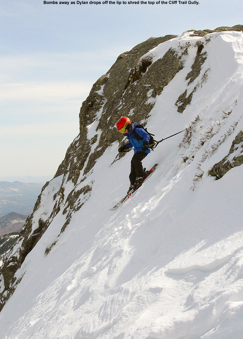
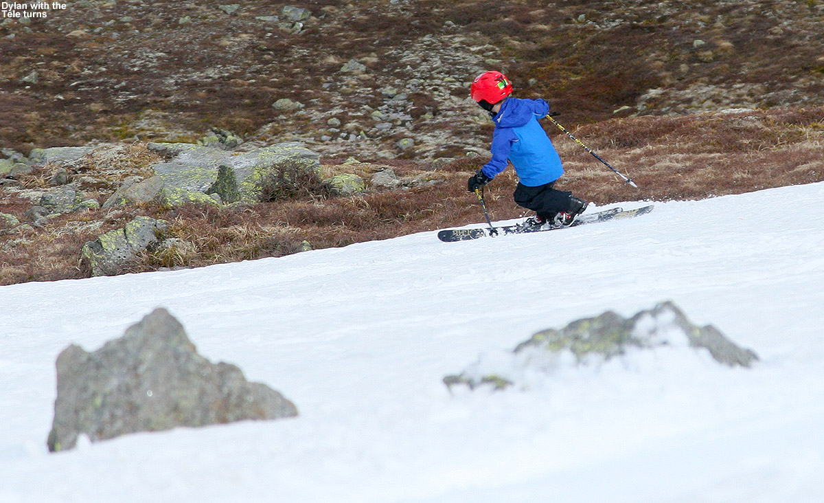
Dylan out on the snow today among some of Mt. Washington’s massive boulders
Last weekend’s weather was a bit too dicey to get us to head over to Mt. Washington for skiing, but the forecast for good weather this weekend was looking pretty solid. E was feeling the need to get other work done with the end of the school year closing in, so the boys and I decided to just go for a day trip to the snowfields. Typically we throw in some camping in the White Mountains as part of our Mt. Washington ski trips, so this would be the first time in a while that we’d be doing the out and back in a day. It’s actually just a couple hour trip to get over to the base of the Mt. Washington Auto Road from our place in Waterbury, so day tripping is certainly practical, but breaking up the driving with some camping has been the routine these past few seasons.
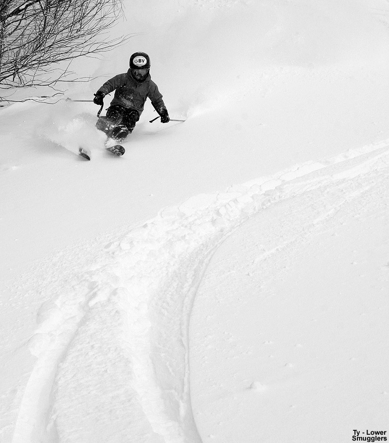
“The snow was great, being a bit harder in a few spots, and a bit softer in others, but the bulk of it was just right for making turns.”
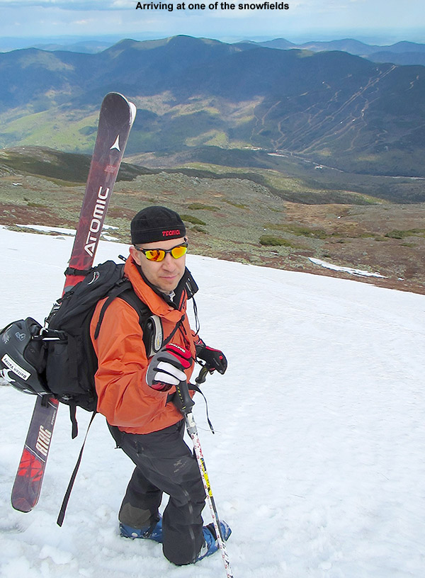
I did a final check on the forecast for roughly the 5,500’ level on Mt. Washington this morning, and it called for leftover frost, clear skies, a high around 50 F, and light winds in the 10-15 MPH range. That’s an excellent forecast for some skiing in Mt. Washington’s alpine areas, and it’s good to jump at these sorts of days, because you never know what the next one will bring when it comes to the Mt. Washington and the Presidential Range. The boys and I headed out around 9:00 A.M. under blue skies and temperatures in the 60s F, and by midday we were up in the parking lot along the Nelson Crag Trail at ~5,700’ getting our gear together. The weather was great, and the numbers on the board showing the summit weather conditions had been right in line with what the forecast suggested. After checking the images from the Ravines Cam over the past few days, as well as this morning, I could see that one of our favorite snowfield areas below Ball Crag was of decent size, so that was our planned destination. We like that Ball Crag snowfield because it doesn’t see nearly as many visitors as the main East Snowfields below the summit, and instead of having to park above it and hike down into the snow, you can contour right across from the parking area along the Nelson Crag Trail. It can be a bit harder to find some of those lower snowfields if you’re not familiar with the area, but we usually have good luck traversing out from near the junction of the Nelson Crag and Huntington Ravine Trails.
Checking the Ravines Cam this morning to orient ourselves to the available snowfields
“The snowfield was a totally clean slate of corn, with no traces of previous skier activity…”
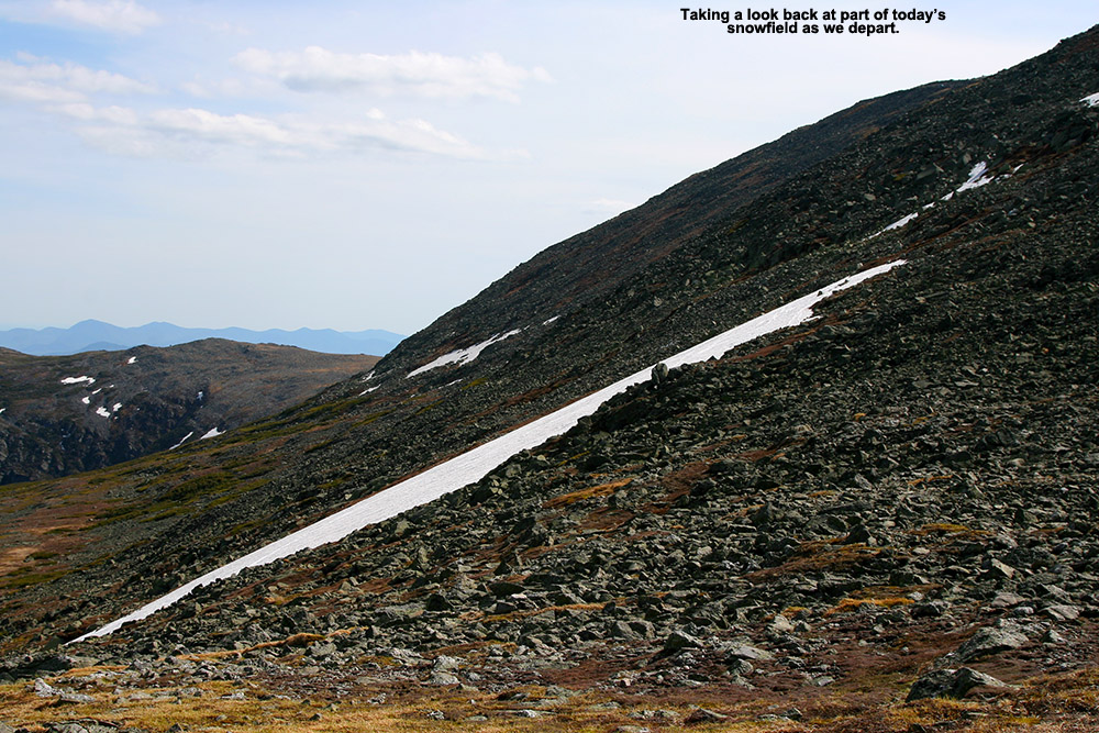
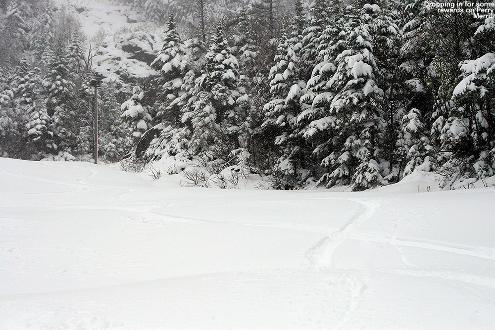
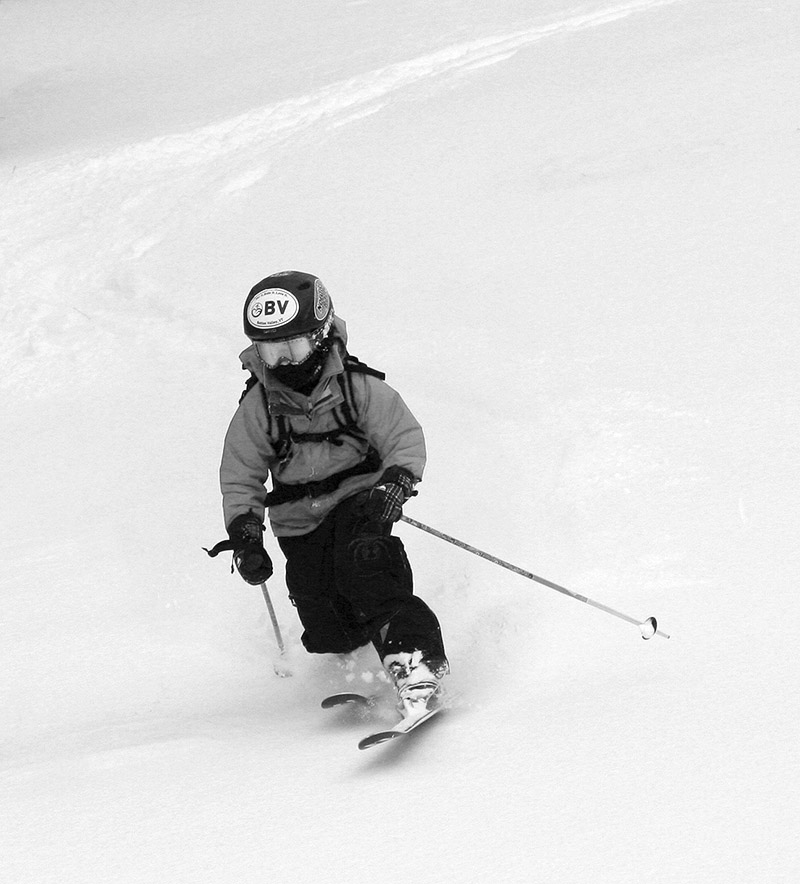
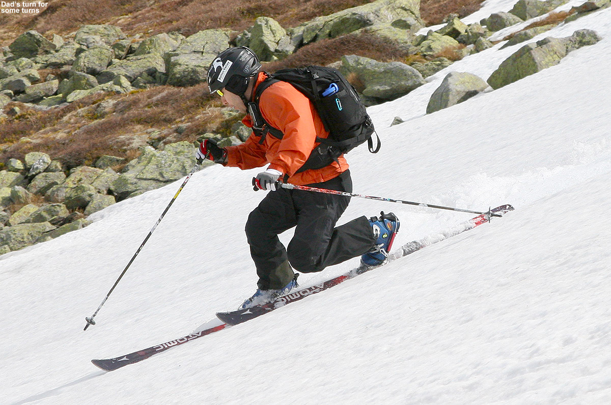
Today the traverse out to the snowfield was incredibly quick – within 5 to 10 minutes (Ty says it was 7 minutes) we’d hit the snow. The snowfield was a totally clean slate of corn, with no traces of previous skier activity, so presumably nobody had skied it in a while. The scene was quiet when we arrived, but it wasn’t long before the boys started having fun with the snow and the activity level ramped up. The boys had a great attitude about the skiing today, certainly relative to some trips we’ve had, and although it was different since Mom wasn’t there, I think they enjoyed the “boy’s day out” sort of feel. We made an initial ski descent of the snowfield, which seemed to provide somewhere in the range of 200 feet of vertical. It was a reasonably long run in which you could certainly get a groove going, and there were a lot of different options for skiing in the various nooks and crannies of the snowfield’s footprint. The snow was great, being a bit harder in a few spots, and a bit softer in others, but the bulk of it was just right for making turns. I told the boys that I’d bring their skis back up for them so that they could enjoy the hike, and strapped their skis on my pack along with mine. It actually wasn’t a bad pack load, and I think it helped to keep their spirits up.
Part of today’s terrain
Back at the top of the snowfield, we had lunch, and the boys again played around in the snow for a while. There was just a bit of breeze at times, and bugs were virtually nonexistent, so it was a great day to be out on the snow. During our first run, a couple with a dog had arrived for some skiing, but they spent their time a little farther over on the snowfield, so we didn’t see them much. It was actually good that they had their own section in which to hang out, because Ty and Dylan were a bit boisterous in their play, and that way the boys weren’t too loud in their immediate vicinity. For our last run we decided to run out the snowfield to the bottom, then contour back over to the Huntington Ravine Trail and take that right back up to the car. That hike took a bit longer since we were starting out lower in elevation, but I’d say within roughly 15 minutes we were back at the parking area. The boys still played around a lot today, so that took up plenty of the afternoon, but this has to be our most efficient outing in terms of the hiking. The snow will likely be around for a bit longer based on what we saw, so there should be snowfield turns available for those that are interested as we move forward in June.
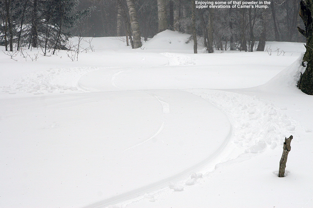
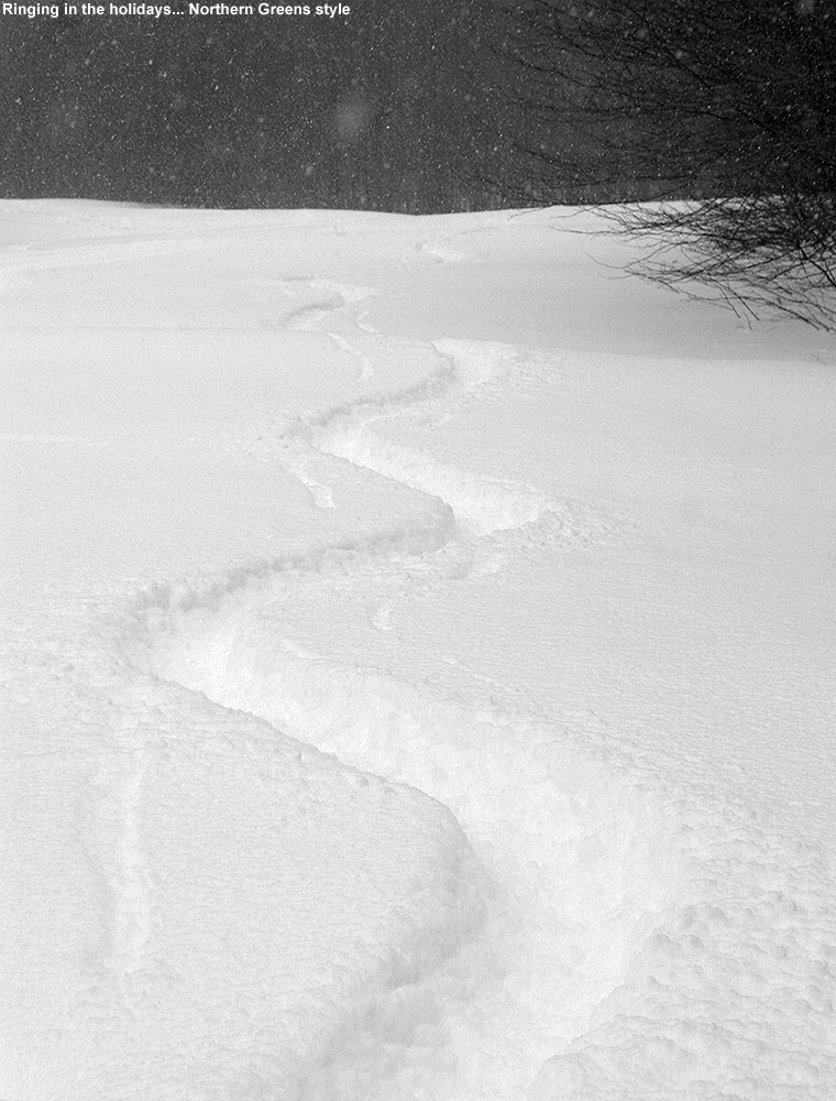
After a Northern Greens fluff bomb visited the area last night, we got some incredibly great snow above treeline on Mt. Mansfield today.
Overnight we had one of those classic Northern Greens mini upslope snow events – the kind that almost seem to come out of nowhere and drop localized fluff bombs of Champlain Powder™. We’d been up at Bolton Valley yesterday from mid morning to mid afternoon, and by the time we left, it was really dumping up there – snow accumulation on the road was down to ~1,500’, and snow/mix was down to ~1,000’. It was still just rain down at our house in the bottom of the Winooski Valley at the 500’ elevation, and that was essentially all I’d noted about the weather before we went on with our evening indoors. We’d watched the second Hunger Games movie, which kept us pretty enthralled for a good couple of hours, and it was a while before I checked in on my computer to see what weather discussion was going on in the Northern New England thread at the American Weather Forum. I noticed eyewall in Burlington reporting some snow accumulation, and it prompted me to take a look out back. Low and behold, it was dumping snow out there, easily 1” an hour type snowfall, and there was already a couple fresh inches of snow down. By the wee hours of the morning, we’d picked up half a foot of snow at the house, and of course that got me thinking about what was going on in the mountains.
“The snow in the chute looked so good it was almost spooky.”
My thoughts of a very early departure to Stowe for me and Ty were stymied by the fact that I had to get some work done and send it off to Stephen, but we managed to get going by around 9:30 A.M. I hadn’t eaten by that point, and we stopped in at the DD on Route 100 to really calorie up with some hearty food. Although he’d had some breakfast, Ty followed suit with at least a cream cheese bagel; it was a good idea, because I suspected we’d need those calories, and as we’d find out later in the day… they were going to be burned. We got to the mountain by mid morning, and the slopes were looking very good. The resort was reporting a fresh 9 inches overnight, and they appeared to be in the sweet spot for accumulations. We were of course really happy that the surprise dump of snow coincided with our usual Sunday visit to the mountain. We’d dressed warmly since temperatures were around 10 F, but truth be told, the temperature just didn’t have the bite that it seems to in January. It’s mid March, and either we’re acclimated, or the March sun just helps to fight off the cold.
Warmin’ up for the day
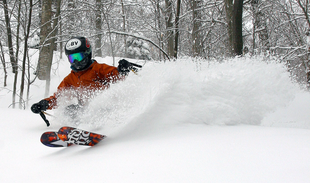
Ty and I kicked things off with a run on the Sunny Spruce, featuring some Lower Smugglers Trees just like we’d done a couple of weeks ago, followed by a visit to the terrain above Meadows. The new snow was indeed light and dry, and the skiing in the trees was awesome, although the base was stiff in low elevation areas that were unprotected from the sun. I’d suspected that as a possibility based on the dense snow we’d found in the lower elevations at Bolton Valley yesterday, so after that warm up run our plan was to head right up into the higher elevations of Mt. Mansfield, where we knew the snow would be very well preserved.
We started off with a trip along the Kitchen Wall traverse, and hit some of the deep powder there. There had really been minimal traffic through the area at that point, so we just picked an untracked area in one of the first snowfields and had at it. That essentially led us on a long and meandering trip through various areas of tree skiing that brought us to the Fourrunner Quad. From the top of the quad I took Ty down Pipeline, which I probably haven’t skied in 20 years. I was happy that I was able to find it, but less enthused about how narrow it was. My skis have only gotten shorter since 20 years ago, so I have no idea how I skied it back then. It was already well packed out, which probably doesn’t take much, since in general people are going to side slip a lot of it anyway. It was just as steep as I remembered though, and the fall away views were spectacular. We eventually found ourselves dropping into the Hazelton Zone from the south side, and that resulted in a great run with tons of untracked snow. Somehow we even managed to get into some of the same lines we’d hit back on the 2nd, and I think our noses naturally lead us in certain directions. Knowing more about some of the big, north-facing gullies though, we managed to get ourselves into one of those, and that was pretty sweet. We’ve still got several of those to explore however, the trick is just finding exactly where to enter the zone to get there.
Ty sending up a huge spray of powder out there in some of the trees on the lower elevations of Mt. Mansfield
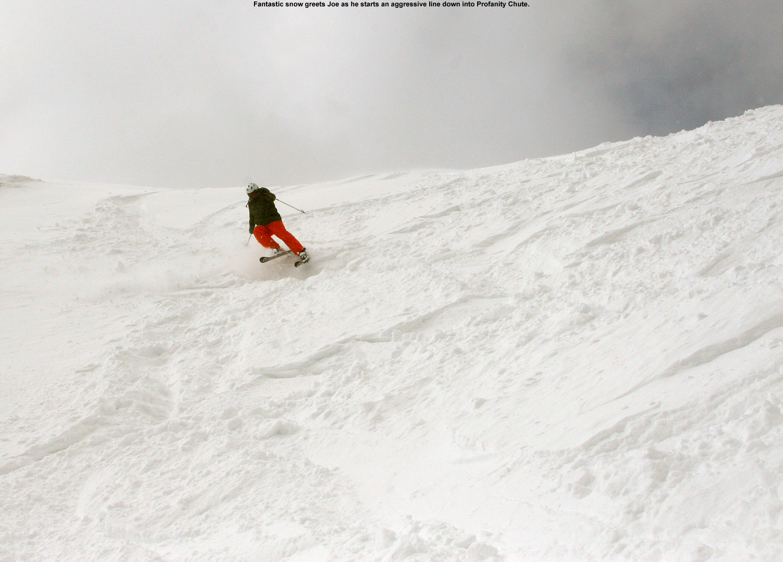
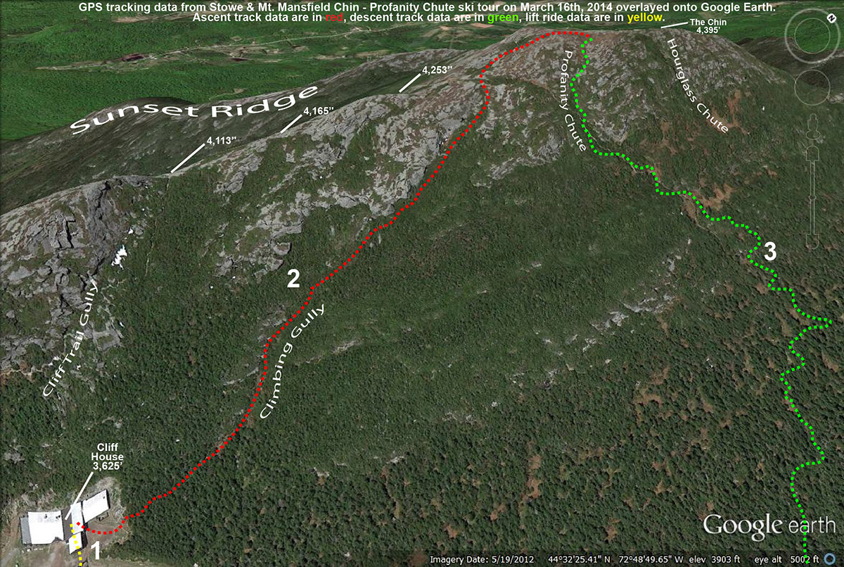
By the time we traversed out of the Hazelton Zone, it was time to head over to Spruce Peak for some lunch, and to meet up with Dylan, E, and all the other folks for the afternoon BJAMS ski program. After climbing and skiing the Cliff Trail Gullylast Sunday as a refresher, today the plan was to kick things up a notch and visit Profanity Chute. Skiing Profanity is a bit of a larger endeavor, since it involves going all the way to the top of The Chin, with a longer hike and a longer descent. This was a great day for it though, with a couple feet of snow midweek from winter storm Vulcan, topped off with another 9 inches of fluff from the overnight snows, the odds were favoring some really nice snow in the alpine. Joe had heard about our plans, and since he was interested in bringing his group up as well, we joined together with him, Ethan, and Julia to make a nice gondola-sized group of eight.
I’d checked on some of the boys packs down in the lodge, so once we got to the top of the gondola, the preparation for the hike went fairly smoothly. The ascent of the Climbing Gully was a little slow at first, simply because of all the fresh snow. The boot ladder was just not consolidated enough. That issue gradually waned as we got up into terrain that had been brushed by the wind a bit more. About 1/3 of the way up the gully, we stopped for a break and to let Jack and Kenny catch up with the group. In order to give them a rest, we waited a bit longer, and with temperatures in the single digits, we had to worry about getting too cold. In the upper half of the hike, I eventually had to put Kenny’s and Jack’s skis on my pack to allow them to keep pace with the rest of the group. That worked well though, and we eventually got everyone up to the Chin and the area atop Profanity Chute. Winds were probably 30-35 MPH up along the ridgeline near The Chin, but fortunately we were able to quickly get on the leeward side of the mountain by the chute.
The snow in the chute looked so good it was almost spooky. There was just one obvious ski track over on the skier’s left, but the right side was a huge field of what appeared to be powder. Just to be safe and to check on wind loading, I ski cut through that area to make sure it wasn’t going to release. It passed that test, and we let the kids just rip it up. I didn’t even have time to get my camera out because they were so quickly enamored with what lay beneath their feet. Indeed that was some mighty fine snow we hit, two to three feet of soft powder, with the denser accumulations from Vulcan topped off with last night’s fluff. I was at least able to shoot some images of Joe in the chute, since he’d waited for all the kids to go. The kids were treated to some fantastic conditions up there, with almost no tracks all the way down the second part of the chute toward Taft Lodge. There’s not much to say other than that the snow was deep, bottomless, and everywhere; that leeward side of Mansfield just really knows how to do snow right.
After following the mazes of tracks and bobsled runs through the subalpine area, getting down to Chin Clip, and then skiing all the way to the base, it was time to head back to Spruce Peak and call it a day. The kids really earned high marks today, and I was amazed at how comfortable with the exposure of the chute up in the alpine. I think that the amazing snow helped with that of course, because even when people did fall, they just immediately stopped thanks to the deep powder. The temperatures were doing a great job of preserving the snow, even when the March sun came out, and it looks like those temperatures will continue to keep preserving the snow as we head into the coming week.
A Google Earth map with GPS tracking data of today’s ski tour to Profanity Chute in the Mt. Mansfield Alpine area – Click to view the full size image.
It was the BJAMS boys dropping powder bombs off the Mansfield ridgeline today.
Jack had inquired about a hike to The Chin during our BJAMS ski program last Sunday, so while getting my ski group up into Stowe’s alpine terrain has been on my mind over the past couple of weeks, that really got me thinking about a hike for today. The snowpack at the Mt. Mansfield Stake has been sitting at roughly 60 inches for the past three weeks, so I’m satisfied with base depths, and the only other concern that would affect the quality of the skiing would be the usual suspects up there in the alpine like wind and sun crusts, etc. Temperatures also looked reasonable for today, with highs in the 10s and 20s F, and with no strong winds expected and lots of sunshine, it seemed like we were on for a trip above tree line.
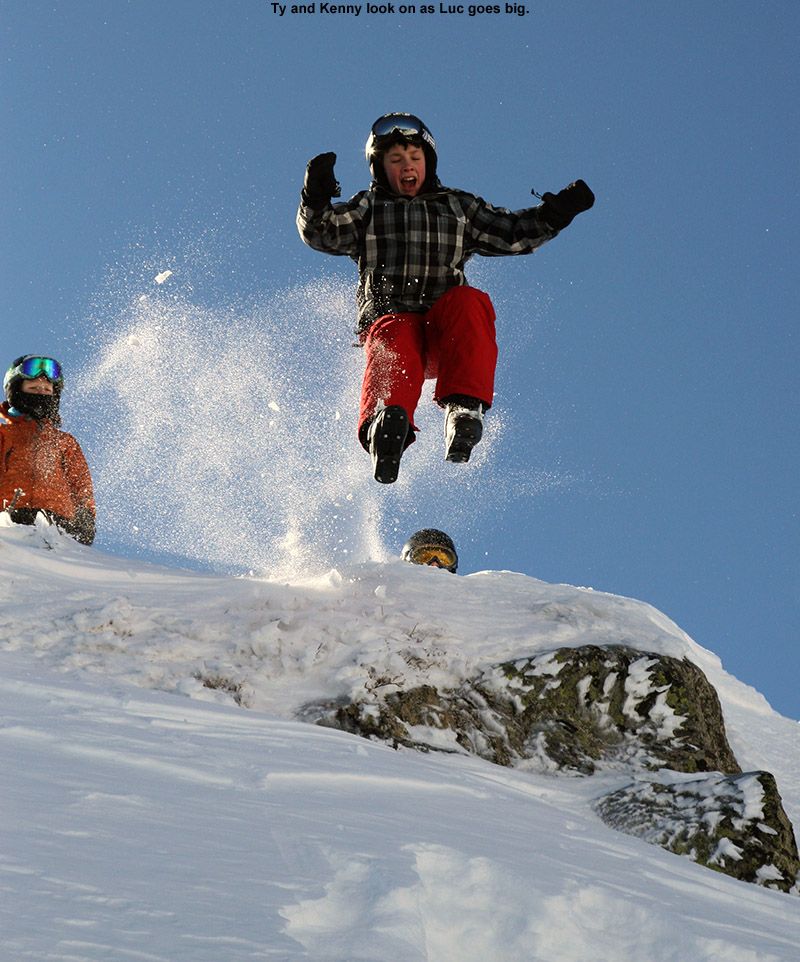
“I shot a few pictures of the accomplishment, and then came the highlight of the trip… the jumping.”
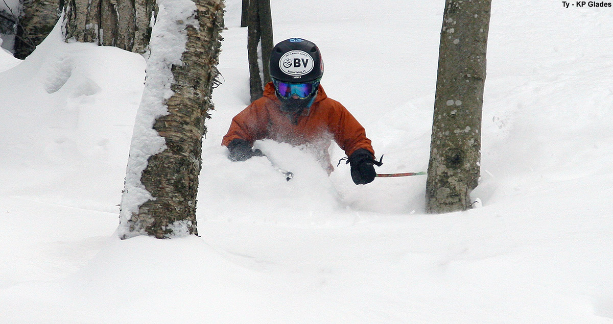
Although I’d like to get them up onto The Chin into Profanity Chute at some point, with no direct knowledge of the current snow conditions in the alpine, and this being the boys’ first hike above tree line this season, something a little less aggressive was in order. So, just like we did for our alpine outing on April 7th last season, I decided to go with a hike up Cliff Trail Gully, followed by skiing in that general vicinity. With that plan in place, I met up with today’s group, which consisted of Kenny, Ty, Jack, and Luc, and informed them of the plan. While Dylan is feeling quite chipper after his recent bout of illness, we want to make sure that his physician says he at 100% before we subject him to anything overly rambunctious. So, after grabbing the feature photo on our last trip up Cliff Trail Gully, unfortunately he had to hold out in the base area today.
After a warm up run on Sunny Spruce with Connor while we waited for Jack, everyone was finally ready to go, so we headed to lockers to prepare the gear. The guys got any water and snacks together, I did some fitting of their packs, and we were off to the Gondola. Up at the Cliff House, I helped everyone attach their skis to packs, and in general after working with Kenny’s setup a bit, the arrangements were pretty good without too many skis hitting heads or legs. Luc was carrying his skis, and I talked with him about switching arm positions as need and trying to let his shoulders do as much work as possible so that his arms wouldn’t get too tired. Kenny was very excited, because he said it was the first time he’d ever hiked for skiing.
Up the boot ladder go the boys
There was a decent boot ladder in place, so Ty took the lead, the other boys followed, and I brought up the rear. Ty was off like a shot, and within minutes it seemed like he was ¼ of the way up the gully and I had to reel him in a bit and tell him to hold so that the group could catch up. He was good about that, and hung out on one of the obvious stopping plateaus created by the massive room-sized boulders that fill the gully. Kenny was taking his time while he figured out what this whole “hiking with skis” process is all about, and I while I hung out with him, I gave him lots of tips on how to move efficiently in the terrain. He was floored by how fast Ty flew up the gully, and I let him know that Ty had done an awful lot of this kind of hiking and that he’d be much faster as he got used to it. The boot ladder wasn’t too bad, but in some spots you could tell that it was made by someone with fairly long legs. That set the boys at a disadvantage, but they worked it out, and I’m sure Ty was putting in plenty of shorter steps that they got to use. I did get to express to them how if they’re ever the first to set the boot ladder, shorter spaces between steps are the way to go, as they work for everyone.
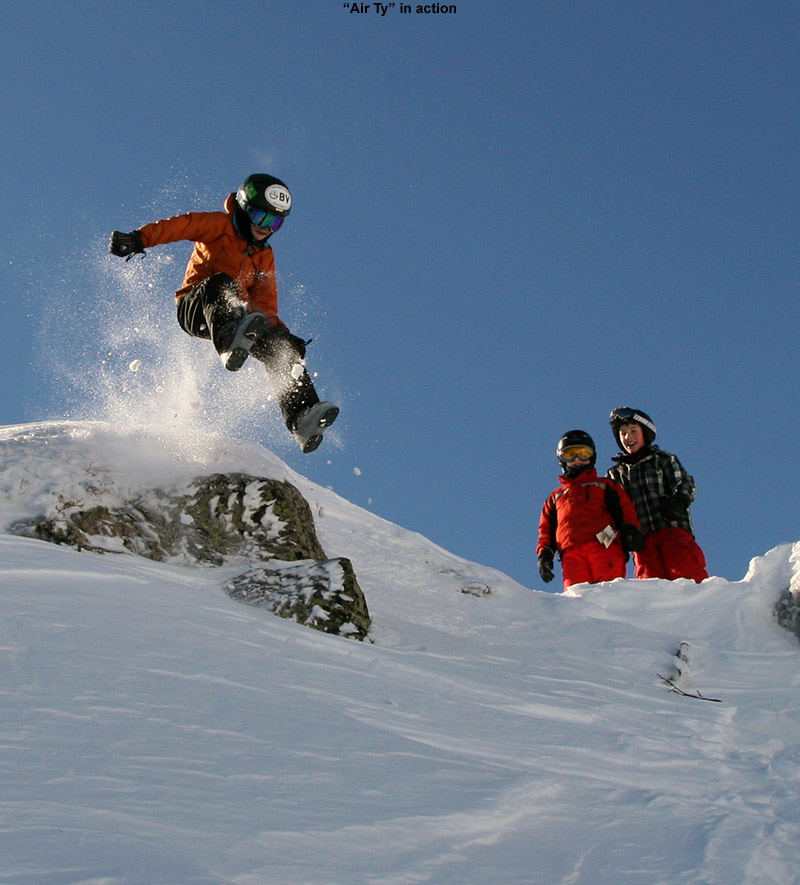
As we climbed higher in the gully, Kenny was very impressed by the views, and I told him how they would just keep getting better with every step. Kenny really started to catch his groove with the hiking when we got into the upper, less steep half of the gully, and he commented on how much easier it was getting. Once into the upper half of the gully, Ty and Luc quickly gained the ridge line, and it wasn’t long before the rest of us caught up and we were there. The wind was minimal and the sun was warm, so the boys immediately started to explore the immediate area above the gully. I shot a few pictures of the accomplishment, and then came the highlight of the trip… the jumping.
It was jumps, jumps, and more jumps!
There hasn’t been much snow to set up a big cornice along the ridge, but there was at least a little bit of one, and more importantly, plenty of snow deposited just below on the leeward side of the ridge. I can’t recall who suggested it first, but the boys quickly got into a session of leaps, slides, tumbles, and bomb holing, all thanks to the deep snow deposited below the ridge. I’d say they had a good half hour session of jumping before I reminded them of the time and pointed out that we weren’t going to get in much additional skiing today if we didn’t get going. The boys were able to pull themselves away, and after a few snacks, we started our descent of the gully.
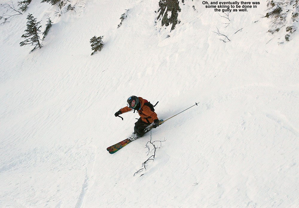
Finally, the boys made the ski descent of the gully.
The snow conditions were actually somewhat challenging, with a few pockets of soft snow, but a lot of wind slab, dense snow, and even pockets of leftover rain crust. The boys really showed their technical abilities, applying a range of techniques to take on some impressively steep, tight, and scratchy lines down the gully. I kept my eyes peeled for other options off to the skiers left, but with the current snowpack, nothing immediately jumped out that was worth pursuing. So, the boys finished their run right down through the Cliff Trail Gully itself, and it was quite impressive.
Of course, one great part about a run down from Mansfield’s alpine areas is that you have an entire run of 2,000+ vertical feet still to go. The boys chose Mac and Cheese, which actually seemed sort of tame after what they’d just done. We followed that up with some trees and bumps on Lower National. We also had time for one more run over at Spruce Peak once we got back. Actually, despite the time taken up by the hike and the run down the gully, I’m glad the boys spent a lot of time up there, because in general, the conditions on piste were pretty unimpressive. The off piste snow in places such as the Nosedive Glades was reasonable packed powder, even if well packed after this past week with minimal new snow, but trails with snowmaking and high traffic are really quite icy. There’s powder in the trees, but naturally it’s getting harder to come by at this point, and the boys weren’t really missing out on too much down below. Luc even commented on how he didn’t like the snow when we were down on Lower National, so he’s definitely refining his preference for good snow. Fortunately, it looks like we might get some storms this week, so hopefully we’ll have some softer conditions next weekend. Hopefully we’ll be back at Stowe for more fun in the snow.
Out for some powder on the east side of Camel’s Hump today
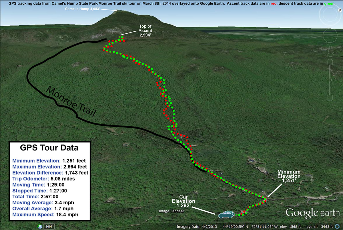
It’s been a light week for snowfall here in the Northern Greens; since the storm that hit the area last Sunday, we’ve had generally cold and dry weather, with just one small round of snow in the Tuesday-Wednesday timeframe. That got me thinking about a backcountry tour for today. My initial inclination was to head northward, since as our snowy Sunday outing at Stowe confirmed, the northern mountains had really picked up the most snow, and accumulations tapered off as you headed southward. With that in mind, I was thinking of heading to Nebraska Notch for some turns. However, yesterday’s and today’s weather history also needed to be factored into the mix. Temperatures reached above freezing in some spots yesterday, and today was looking similar, so I figured that something sheltered and with relatively high elevation was the way to go for the best snow. I decided to head to some of the skiing around the Monroe Trail, on the Waterbury/Duxbury side of Camel’s Hump. I had planned to have Ty come with me, but at the last moment he decided that he didn’t want to skin today, so I said we’d head up to Bolton Valley for some lift-served turns when I got back from the tour.
It’s been over four years since I last visited the Monroe Trail area of Camel’s Hump for skiing. On that outing, I followed the Monroe Trail up to the large cliffs beneath the peak of Camel’s Hump, then traversed somewhat northward to set up for a descent fairly distant from the trail and toward the glades that drop down near the trailhead. I got in some good skiing in the trees, but really just caught the end of the glades, so I knew there would be more lines to explore. This time, my plan was to simply skin up one of the descent tracks made by skiers coming down through the glades, since it would save a lot of time traversing around up high to find the best starting points.
I headed out from the house a bit before noon, and temperatures were in the mid 30s F. The temperature fell as I headed up Camel’s Hump Road, dropping to 31 F by the time I reached the winter parking area at ~1,200’. Just a couple hundred feet below the parking area, I’d seen the first flakes of snow from a small system that was expected to come through in the afternoon. From the trailhead at ~1,500’, I skinned up the Monroe Trail for a few more minutes and then as the trail started to bend southward, I jumped onto one of the ski tracks coming down out of the obvious glades in the terrain above. The tracks traversed northward for a bit, but then gradually began to make a more direct ascent up toward the east face of Camel’s Hump. I was a little worried about the snow quality, because although it was below freezing and most snow that wasn’t in the sun was still wintry and dry, there were only a few inches of powder above an old crust. I wasn’t quite sure how that was going to ski. But, the snow got better and better as I ascended, with the powder on top of any crust getting deeper and deeper. It was really nice skinning though – the temperatures were just below freezing, the wind was calm, and light snow was falling in association with the afternoon’s storm. I hiked in just a vest over my polypropylene base layer, and quickly had my hat off as well.
As I ascended, it became obvious that the lower parts of the glades represented a common track to regain the Monroe Trail, but in the higher elevations, there were a number of interconnected glades from which to choose. About halfway through the ascent, I stuck with a glade that was generally on the skier’s right of the area that had seen very little traffic. There was just one very old descent track in it, and that track was actually hard to find at times because so much snow had fallen on it since it had been made. I knew that there were other glades around to my north, because I saw a couple of skiers descending in that area. After generally rejoining with tracks from some of the other glades, I traveled for a bit through more gently sloped terrain until I hit the trail for the Camel’s Hump Challenge at roughly 2,800’. I followed that northward a bit more until I topped out around the 3,000’ mark in some of the upper glades just below the Cliffs of Camel’s Hump. The quality of the snow had definitely improved up at that elevation, with any crust buried below several inches of powder.
I had a snack, switched my gear over, and then began my descent. There were some decent turns above the Camel’s Hump Challenge Trail, but the best turns were definitely when I got onto that lesser used glade below that point. The highest quality snow was in the top half of the vertical, and with my fat skis it was generally soft, bottomless turns. On the lower half of the descent, even my fat skis weren’t enough to always keep me floating, as the depth of the powder decreased to just a few inches; to best handle any partially tracked and/or narrower sections of terrain, I had to inject a lot more alpine turns into the mix vs. just Telemark turns. I did venture off the main glade that I was on at times, and there was plenty of skiing to be had right in the natural trees all around. I saw one other skier as I was descending – he was ascending through the glades as I’d done. He and his dog moved out of the way when he saw me off in the trees beyond the glade, but after I let him know that I was solo and nobody else would be coming down behind me, he quickly resumed his ascent.
Just as I’d experienced on my last outing in the area, from the bottom of the glades it was an easy downhill ski on the Monroe Trail itself. I was even able to catch some turns in the powder off to the side of the snow-covered roadway below the trailhead, then shouldered my skis to walk the last tenth of a mile back to the parking area. The temperature was 31 F just as it had been when I arrived, and the light snow had mostly tapered off down at that elevation. Despite the deeper snow and lack of a defined skin track in the glades relative to the beautifully packed nature of the Monroe Trail, I almost wonder if it’s more efficient to ascend in some cases because it’s a much shorter distance due to the way the Monroe Trail wraps around so far to the south. In terms of preserving the powder and ascending if the unconsolidated snow is deep and there aren’t many descent tracks, the Monroe Trail is the way to go, but now that I’ve gone up via both routes, I’d say they are both pretty convenient options. Hopefully I can get E and the boys along on one of these Monroe Trail trips – now that I’ve had a couple of sessions out there, I think I could guide them on a great tour.
The GPS data from today’s backcountry ski tour overlaid onto Google Earth
Getting ready to drop in for some first tracks in Breakfast Bowl this afternoon
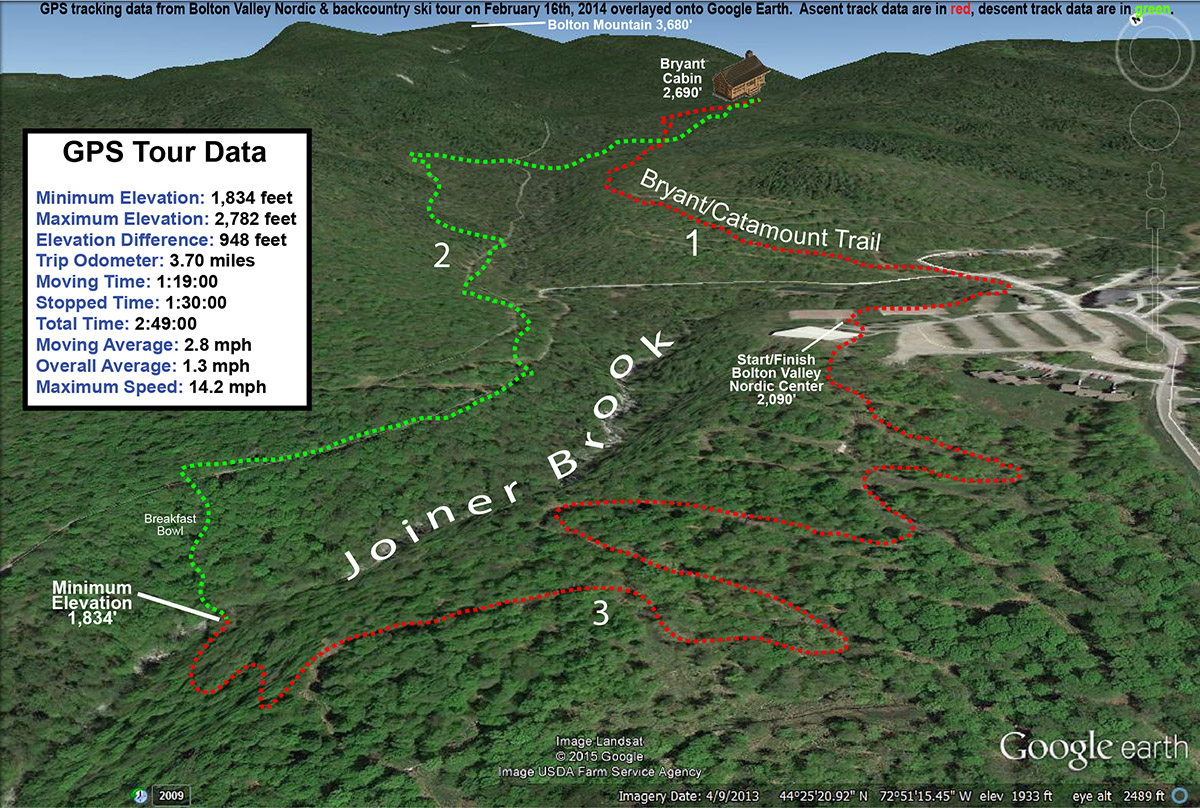
We had a great day of lift-served skiing at Bolton Valley yesterday thanks to almost two feet of new snow from Winter Storm “Pax”, but today looked to be colder and windier, so some backcountry touring seemed like a good fit. It was such a gorgeous midwinter day today in the valley, with lots of sunshine, and highs around 20 F. The boys were more interested in sledding than skiing, but at least they were getting out enjoying the day. E stayed home with them and ended up doing some snowshoeing, but I headed up to the mountain for a tour. There had actually been a few more inches of fluff overnight in association with upslope flow from Winter Storm “Quintus”, so that new snow simply topped off what came from the larger storm.
“The settled powder was 25” deep up at Bryant Cabin, and assessments throughout the day revealed that to be pretty consistent at most of the elevations I visited.”
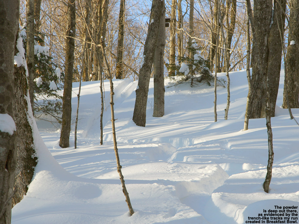
Since I was solo, I decided on an interesting tour that would hit some common spots as well as some new areas that would let me check out some additional glades. I began with a standard skin up to Bryant Cabin via the Bryant Trail, which went quite quickly without any real stops. I actually had my pass checked by one of the resort employees out on the trail, so the resort is keeping up on that. The settled powder was 25” deep up at Bryant Cabin, and assessments throughout the day revealed that to be pretty consistent at most of the elevations I visited.
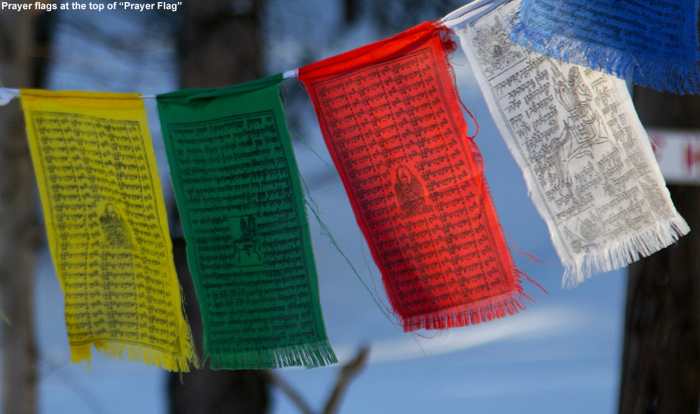
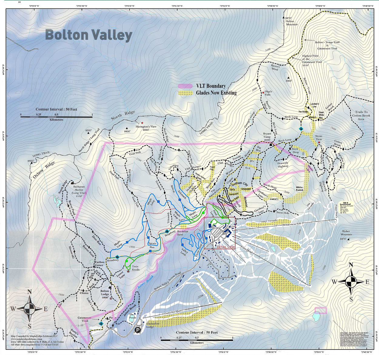
From Bryant Cabin I headed out on Gardiner’s Lane and descended via JJ’s. There had been some skier traffic in the area, but there were various lines with fresh snow, and everything was simply bottomless and soft. I cut across to Possum, merged onto Cliff Hanger, and then skinned up to reach the top of Prayer Flag. Although I’ve explored that area before, I didn’t really know the name of the run until I saw it on the new Bolton Valley Backcountry Map. There was only one track on Prayer Flag, and it seemed to be an ascent track. The turns were good, and it was trench city with respect to the track I left. It was actually a bit much in the way of new snow for shallower grades, but for the steeper pitches it was excellent.
The powder was so deep today that ski tracks were often trenches.
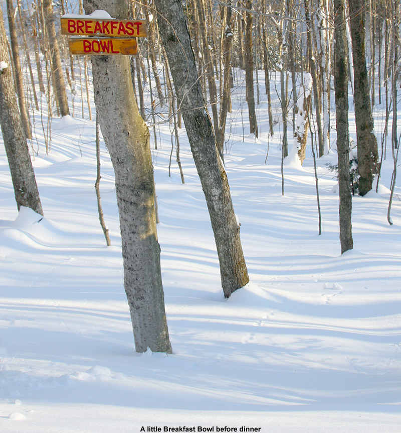
From the bottom of Prayer Flag I headed out toward “Breakfast Bowl”, a glade I’ve never skied before, and noted that the tracks looked really good coming down out of Holden’s Hollow. I found Breakfast Bowl totally untracked, and those were some of the best turns of the day – there is plenty of pitch there for whatever amount of powder you’ve got. At the bottom of Breakfast Bowl, instead of heading back up toward Broadway, I decided to cut across Joiner Brook, head up to the plateau on the other side, and take the Valley Loop Nordic trail back to the car. On my way up out of the streambed, I really got a feel for the instability of the snowpack. With the upside down snowpack having dense snow on top of lighter, drier stuff, “whumphing” sounds were being made with every step. It felt like a snowpack that would be ready to rip in appropriate terrain, and no sooner had I been thinking about it, than a room-sized slab shifted under me on a fairly steep slope. It only moved a couple of inches since it was stabilized by some trees, but it sure let me know that the snowpack meant business. Finishing my tour on Valley Loop was somewhat slow on my fat skis, but it was relaxing, and I cut a few corners to speed up the process on the very winding trail.
The GPS data from today’s backcountry ski tour at Bolton Valley mapped onto Google Earth
Out for a short tour on Bolton’s Backcountry Network today to get some powder turns with the boys
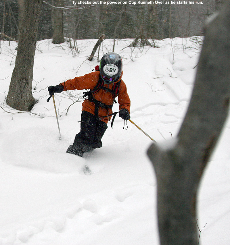
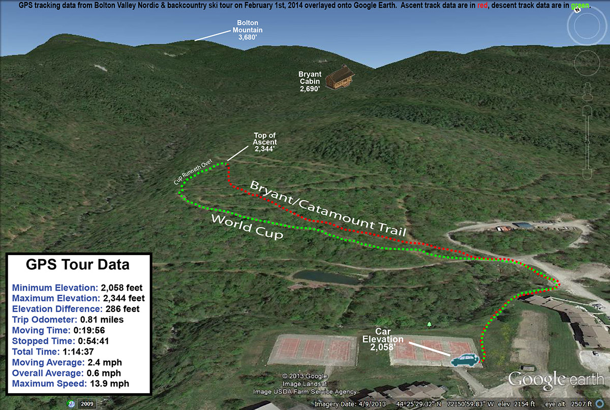
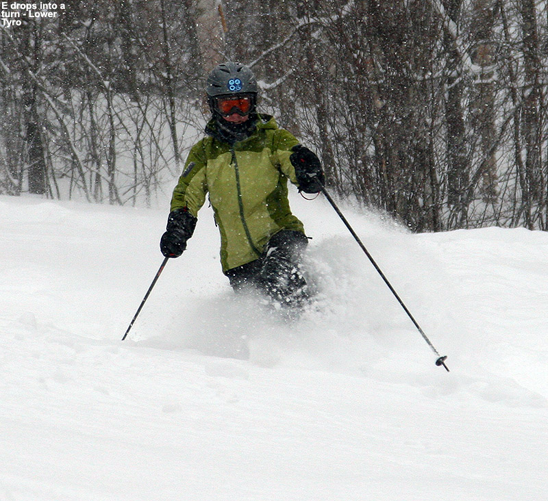
Down at the house, snow from our current storm was just starting to fall around 3:00 P.M. today when I headed up to Bolton Valley with the boys. E had headed off to get some work done at school, so it was just the guys at home, and I figured that we should get out and enjoy the snow for a bit. After getting a closer look at the Cup Runneth Over glade on Sunday, it seemed like a nice, short touring option to try with the boys.
“Skiing in the upper section of the glade was pleasant. Even though there were a number of sets of tracks, there was still untouched powder around, and a good 6+ inches of it.”
The temperature was in the mid 30s F at the house, and the flakes that were falling here and there quickly began to intensify into a steady light snow as we headed down the Winooski Valley through Bolton Flats. Looking out ahead of us toward the west, we could see that that more intense snow was heading our way. With the marginal valley temperatures with this event, the mountains are expected to do notably better with the snowfall, and indeed that was borne out as we headed up the Bolton Valley Access Road and got into sub-freezing air. Snow was already accumulating on the road above ~2,000’, and the snowfall was much more intense up in the Village. The boys quickly covered up with their hoods as we got out of the car and into our gear, because the snowfall would quickly wet you down if you didn’t get yourself under something waterproof.
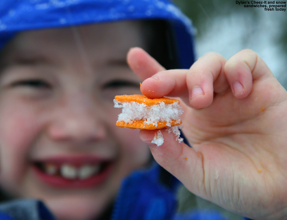
Lights were starting to come on for the alpine trails, and skier traffic was scant on the Nordic network as we skinned along World Cup and then Bryant. The boys hardly believed me when I told them that we were in for just a few minutes of climbing before we’d reach the start of our descent. Indeed that was the case, and we stopped along Bryant at the entry spot I’d seen for the upper section of Cup Runneth Over on Sunday. We relaxed and hung out along the top of the Glade, enjoying the snowfall and the comfortable temperatures just below freezing. Dylan immediately dove into his pack for some snacks, and ended up creating sandwiches comprised of Cheez-It® crackers with snow in the middle. One lone skier passed by us as she made an ascent up Bryant, but, aside from her, all we saw were a couple other Nordic skiers and a guy on snowshoes. With the fairly late hour, it wasn’t surprising that we didn’t see many people.
Skiing in the upper section of the glade was pleasant. Even though there were a number of sets of tracks, there was still untouched powder around, and a good 6+ inches of it. The boys practiced some Telemark turns and stopped down at the intersection with World Cup where the glade starts to dive down a steeper slope. I began the steeper descent, but after I’d made a couple of turns, the boys asked if they could ski World Cup and work on their Telemark turns; they just weren’t feeling confident enough with their turns to take on the steeper part of the glade, and that was probably a good choice for them because I did find the coverage a bit bony. They were definitely enamored with the clean, groomed look of World Cup, made all the more enticing with the coating of fresh snow that was approaching an inch by that point. The boys certainly had a lot of fun on World Cup, trying different variations on their Telemark turns as they pushed around some of the fresh snow.
The GPS tracking data from today’s short tour with the boys plotted on Google Earth
Once we were back at the car, I decided that boys could get a snack at the Bolton Valley Deli & Grocery, and we ended up also grabbing a couple of pizzas at Fireside Flatbread to take home for dinner. I’ve wanted to make use of having the pizza right there in the lodge for a while now at the end of one of these evening tours, and today it worked out perfectly. We had it in hand in roughly 10 minutes, so the guys at the oven were right on top of it.
We headed down from the mountain around 5:30 P.M., and roughly an inch of new snow seemed to be the total at that point, with continued moderate snowfall. This is a storm where areas farther north are expected to get more snow, so we’ll have to see how Stowe does overnight, but there could be some nice skiing tomorrow if the snow keeps up for a while. And the pizza from Fireside Flatbread was excellent as usual – their crust is one of my favorites anywhere.
The backcountry season is definitely underway at Bolton Valley now.
After our fresh snow and reprieve from cold temperatures yesterday, today it was back into the arctic air with highs predicted to be in the single digits F or even hovering around zero in the higher elevations. And of course that didn’t factor in the wind, which brought the effective temperatures down well below zero. Since that was the forecast, E and Claire cancelled our BJAMS ski program at Stowe today; there’s just no reason for dozens of kids to risk frostbite, especially when many of them are so focused on learning to ski that they’re oblivious to what’s going on with their skin.
“Many, many glades have been included on the latest version of the backcountry map, and there are now more than two dozen of them on there.”
Temperatures were in the low single digits when I arrived in the Village, but as I parked down along the edge of Broadway I could see that the Nordic scene was definitely hopping. Numerous skiers swished by as I prepared my gear, including three patrollers heading off to monitor the trails. I definitely felt cold as I geared up, but once I started moving, that welcomed warmth of activity quickly came on, and I rapidly found that pleasant temperature balance between movement and winter cold. Checking the powder depth near the base of the network at ~2,100’ revealed 7 inches, which was encouraging.
“That actually made for quite a unique tour overall, one that brought me from the Nordic/backcountry network back to the alpine network.”
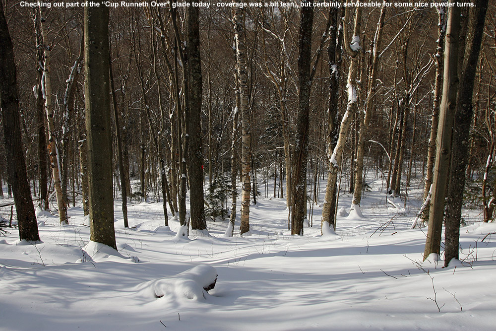
I started out with only a vague plan to head up to Bryant Cabin and assess the state of coverage on the trail network, so that gave me the opportunity for some exploring along the way. For a while I’ve wanted to check out the glade called “Cup Runneth Over”, which I’d read about a while back on the Bolton Nordic Blog, so this seemed like the perfect opportunity to do it. I had printed out Art’s directions to the glade on a piece of paper that I keep in my backcountry pack, and with the help of those and a little poking around, I quickly found it. The coverage looked a little on the lean side, but as I glanced around, I could see that not only does the glade drop below World Cup, it starts up above it – and there was a track on that upper section that clearly showed how the snow was sufficient for turns. I skinned up through that upper section of the glade until it reached the Bryant Trail, and made a mental note of that upper start point for future reference. I can’t believe how many times I’ve passed by that spot on Bryant and never noticed the glade starting off to the left, but that’s what exploring is all about.
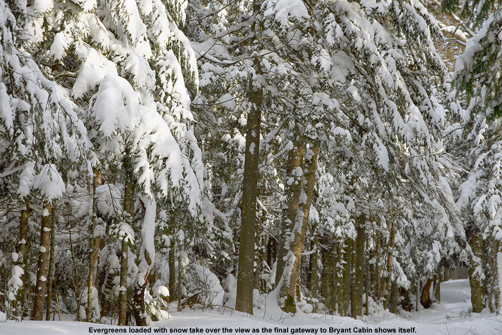
The evergreens were choked with snow today on the upper sections of the Bryant Trail.
It was indeed nice to finally get to see part of Cup Runneth Over, but I wanted to keep exploring, so I merged onto Bryant and headed upward. I noticed what looked like some open trees in the forest below Possum, and did a quick tour through the area to see what it offered. The terrain there really needs no glading, as the natural make-up of the forest would lend itself to plenty of turns. The pitch is such that it would be great after one of those events that deliver 4 to 6 inches of light powder over a smooth, firm base. Much more than that amount of snow though, and the pitch is just not there – even today it would have been slow with the 7 or 8 inches of medium weight snow atop the snowpack, but that was also in part due to the snow being slow because of the cold temperatures. Continuing upward on Bryant, I saw tracks on fairly steep lines like A1A, JJ’s, and Big Blue, and the coverage certainly looked sufficient. I eventually got into the areas of protected evergreens that really hold the snow, and you could see that they were choked with powder. Up at the Bryant Cabin at ~2,700’ I found the powder to be in the 8 to 9-inch range.
“The snow had settled a bit more, some wind had affected it in spots, and it was slow due to the cold temperatures, so while fun, it couldn’t compare to yesterday.”
I decided to continue my tour out along North Slope, and when I finally hit one of the local high points I stopped to take off my skins and have a break with some of the hot soup from my pack. The scene was peaceful, although I could occasional hear the hoots and yelps of other skiers around on the network. I began to descend on North Slope, and actually decided to ride it all the way out to the end because I’d never done that. There are actually a couple of notable uphill sections that require a few minutes of work, but it wasn’t enough that I needed to put my skins back on.
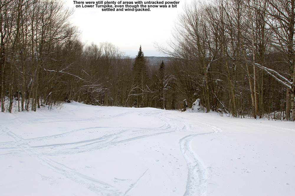
Finishing off today’s tour on Lower Turnpike
Although I saw some good potential in some of the glades, I stuck with my plan to run North Slope all the way out to Lower Turnpike and ski down there, because after yesterday’s experience, I knew it was a sure thing in terms of coverage. That actually made for quite a unique tour overall, one that brought me from the Nordic/backcountry network out to the alpine network. Most of the time I’m using the lifts and going the other direction, so this was a fun change. North Slope has a nice little connecting trail with Lower Turnpike that I’d never seen. There were only a few tracks on Lower Turnpike, so there was plenty of fresh snow, but it didn’t ski nearly as beautifully as yesterday. The snow had settled a bit more, some wind affected it in spots, and it was slow due to the cold temperatures. So while fun, it couldn’t compare to yesterday. I finished off my run with an interesting route through the Village below the Liftline Condos – it actually turned out to be a pretty slick connection with some backyard powder turns that dropped me right down onto Broadway.
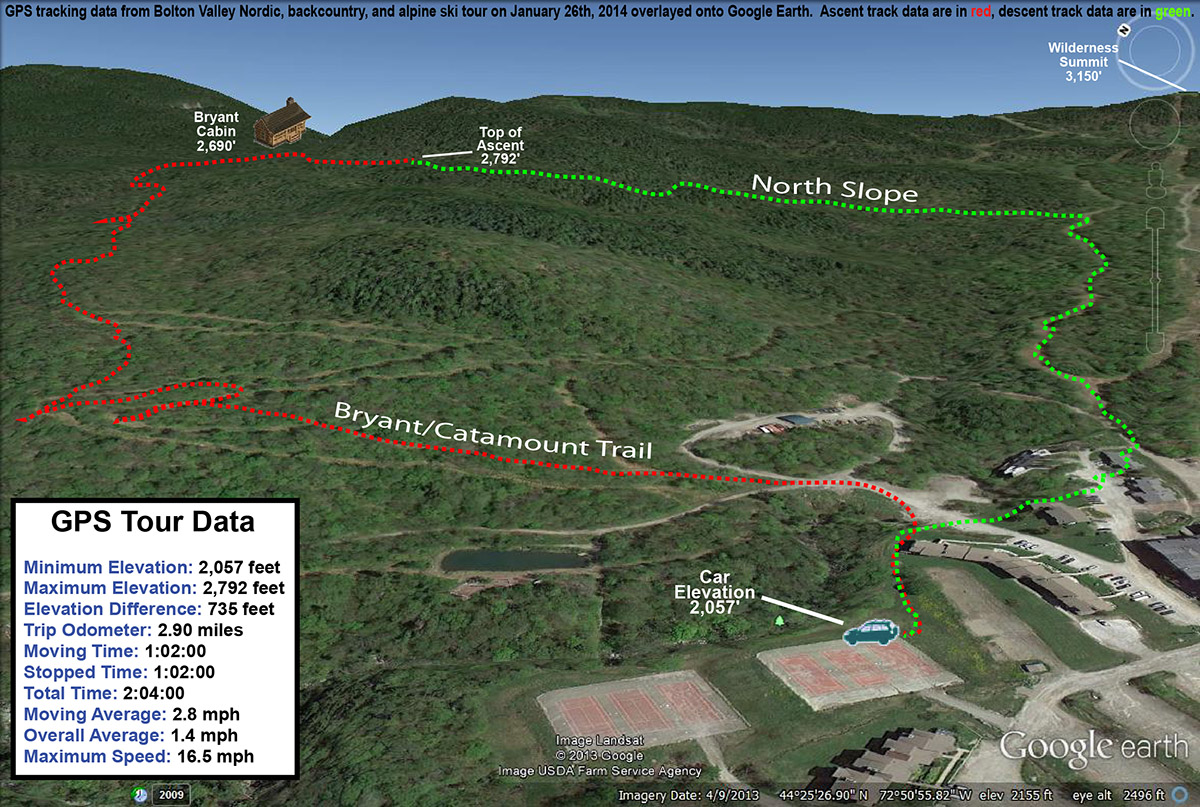
The GPS/Google Earth map of today’s tour from the Nordic/Backcountry Network back to the alpine trails
Another great discovery came this evening, when I visited the new Friends of Bolton Valley Nordic & Backcountry website while writing up my report. I checked out the map of the network that they have available, and it’s the most expansive I’ve seen yet. Many, many glades have been included on the latest version of the backcountry map, and there are now more than two dozen of them on there. It really gives one an idea of just how expansive the opportunities are out on the trial network, and it’s going to be great to see how things go with the new, clearly energized, participation in maintaining the area. As for the trails, everything I saw today looked to be in excellent condition. And, with the snowpack below average for this point in the season and just getting to sufficient levels for backcountry skiing, I’d expect that problems would be relatively easy to see. Thanks to all the folks that worked on the trials this season, and put out that great new map of the backcountry network!
The updated map for Bolton Valley’s Nordic and Backcountry Network now has more than two dozen glades listed
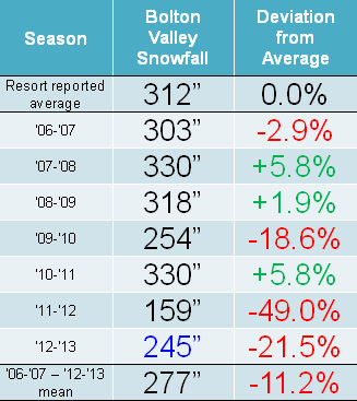
Snowfall: Compared to the snowfall-deficient 2011-2012 Ski Season, the 2012-2013 Ski Season was certainly a step up, but it was still generally below average for snowfall in the mountains of Northern Vermont. It was Bolton Valley that seemed to fare the worst of the northern resorts along the spine of the Green Mountains, perhaps due to their west slope location and this season’s dearth of upslope snow; they reported just 78.5% of their average snowfall. Heading northward, Stowe and Smugg’s fared a bit better at around 85% of average, and Jay Peak reported roughly average snowfall. Down at our house in the Winooski Valley, snowfall was 88.6% of average, so not too shabby by most accounts, but a bit below the mean like some of the local mountains. These past two seasons have actually been the first pair delivering back-to-back below average snowfall in our area since we started keeping track in 2006. Those numbers can be seen in both our Waterbury Winter Weather Summary Table, and the table of Bolton Valley annual snowfall below; this past season’s snowfall is highlighted in blue:
Low snowfall last winter meant back to back seasons with below average snowfall at Bolton Valley.
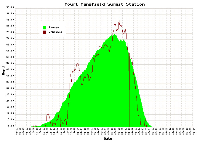
Snowpack: Aside from the spikes associated with a couple of early season storms, the mountain snowpack was below average going into mid December. That changed quickly though, with the onset of all that new snow during the second half of the month. The above average snowpack achieved during the holidays didn’t actually stay that way during January’s warmth and lack of storms. After consolidation, the snowpack generally trundled along at or below average through February’s continuation of relatively low snowfall. From mid February to mid March, the snowpack sat there essentially stagnant for an entire month; to wit, on February 21st, the snowpack was at 65”, and roughly a month later on March 18th, it was still at 65”, without any notable consolidation of more than a few inches. The late season stretch from mid March to mid April represented a nice rebound for the mountains however, with some quick gains from the big Northern New England March storm getting it above average, and the snow depth staying at least modestly above during the period.
Two periods stood out this past season for above average snowfall: The holiday period and mid-March through the end of April.
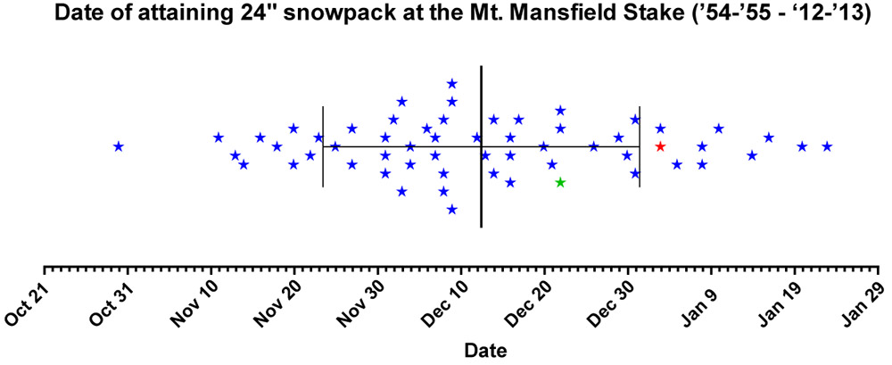
Tree Skiing: One metric used as a rough guide for the start of off piste skiing in the Northern Green Mountains is the point at which the snow depth reaches 24” at the Mt. Mansfield stake. For those unfamiliar with how this metric was established, it’s described in some detail in the 2011-2012 ski season summary. With the incorporation of this season’s data, the mean date remains at December 12th ± 19 days, with an average depth at the stake of 25.9 ± 2.7 inches. After the very slow start in 2011-2012, in which the 24” depth wasn’t attained until January 3rd (more than a standard deviation later than the mean), this past season was notably earlier. The plot below shows the date at which 24” was obtained for each season since 1954, with 2011-2012 shown in red, and 2012-2013 shown in green:
Each star marks the date of attaining a snow depth of 24 inches at the Mt. Mansfield stake, covering all years since 1954. Although still a bit later than average, reaching a depth of 24 inches at the stake this past season (green star – Dec 22) occurred much earlier than the previous season (red star – Jan 3). The mean date for attaining a depth of 24″ is marked by the large vertical bar in the center of the plot, and the smaller bars indicate the range of one standard deviation above and below that mean.
This past season, the date (December 22nd, Depth=28”, Green Star) was still later than average due in part to the slow first half of December, but unlike last season it was well within the 1 S.D. bars (thin vertical black lines). Note that the 24” mark is being used as an indicator of when the first forays into appropriate off piste/tree skiing terrain typically start in the Central and Northern Greens. In terms of empirical tree skiing observations, personal experience again lends some support to the use of 24” mark this season, as we began venturing into the trees the very next day on December 23rd at Bolton Valley. It should be noted though, that while the 24” mark was attained on December 22nd this season, the 40” mark was attained the very next day on December 23rd. The 40-inch rule (i.e. reaching a depth of 40” at the stake), is used as an indicator of when most off piste/tree skiing around here is ready to go. Although I haven’t looked into the data, this season has got to represent one of the quickest ascents from 24” to 40” – it’s interesting to note however that after rising to 42” of depth on December 23rd and 24th, the snowpack settled back to 36” for a couple of days before rebounding to 45” on the 27th.
Snow Quality: As an monitor of snow quality for the season, the chronological list of our ski outings has once again been compiled, with those days in which we were skiing powder indicated by a P, and those days in which powder skiing wasn’t available indicated by an X. The availability of powder suggests a fairly high level of snow quality, and the absence of powder generally indicates that temperatures rose above freezing at all elevations. Each listing below represents a link to the full report where images and more information from the outing can be obtained. Outings with an X may still be providing decent skiing such as wet snow, corn, etc. (or else skiing was typically avoided) but aside from the spring period, there’s going to be a price to pay in terms of snow quality associated with these episodes when temperatures eventually cool back down. The pattern of snow conditions in the Northern Green Mountains was fairly typical this past winter, with those days lacking powder skiing showing up in three distinct periods: 1) the early season with its usual temperature fluctuations, up through mid December before the weather pattern changed and the cold weather stabilized, 2) a thaw period in mid January, and 3) the period starting in mid March where spring weather began to make inroads. However, with the way the weather patterns this past spring continued to provide cool temperatures and snowfall, powder skiing generally dominated until mid April. Having analyzed the skiing in this way for the past three seasons, a surprising level of consistency is noted, with an overall average of close to four out of five days providing powder, despite notable differences in the demeanor of these recent ski seasons. The 2010-2011 season, which was above average in snowfall, provided powder on 78% of outings, the 2011-2012 season, which was well below average in many ways, revealed the same 78%, and most recently the 2012-2013 season, which was slightly below average in this area, produced a very similar 77% of outings with powder. The percentages don’t take into account differences in the number of outings each season, but with all three seasons falling into the range of 50 to 60 ski outings, differences in the sample sizes aren’t huge. The list of categorized ski outings with links to their full reports follows below:
The detailed month-by-month synopsis of the season is next:
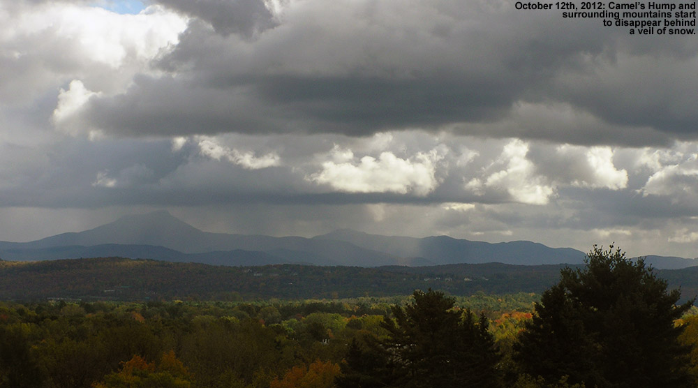
October: It wasn’t an especially snowy October to kick off the season; we had five rounds of snow in the mountains, and the third one even dropped accumulations to the lowest mountain valleys, but none of the storms were huge dumps, and we had just a tenth of an inch of snowfall down at the house for the month. October’s first snowstorm started up on the 7th, with snowfall being reported at the top of the Mt. Mansfield Toll Road in the afternoon, and by the next morning Powderfreak sent along his picture of 4” of accumulation at the top of the Stowe Gondola. I also got a shot of Mt. Mansfield later in the day with its first accumulation of the season. It didn’t seem like quite enough snow to tempt me out to ski, but the FIS boys hit the snow and provided a thorough report of the turns. The second storm delivered some accumulation on the 11th, with a snow line up around the 3,000’ level and less than an inch of snow found up on Mt. Mansfield. The third storm was the one that finally touched the lower valleys with some minimal accumulations, but in terms of mountain accumulations, I don’t think it was anything more than junkboarding material. The 4th (on the 14th of the month) and 5th (on the 16th of the month) storms of October also appeared to be pretty minimal and generally flew under the radar in terms of discussion. So while it wasn’t a great October for natural snow skiing (with nothing like the back-to-back larger storms at the end of October during the previous season), some folks made some turns and there were several smaller rounds of snow to keep the peaks white.
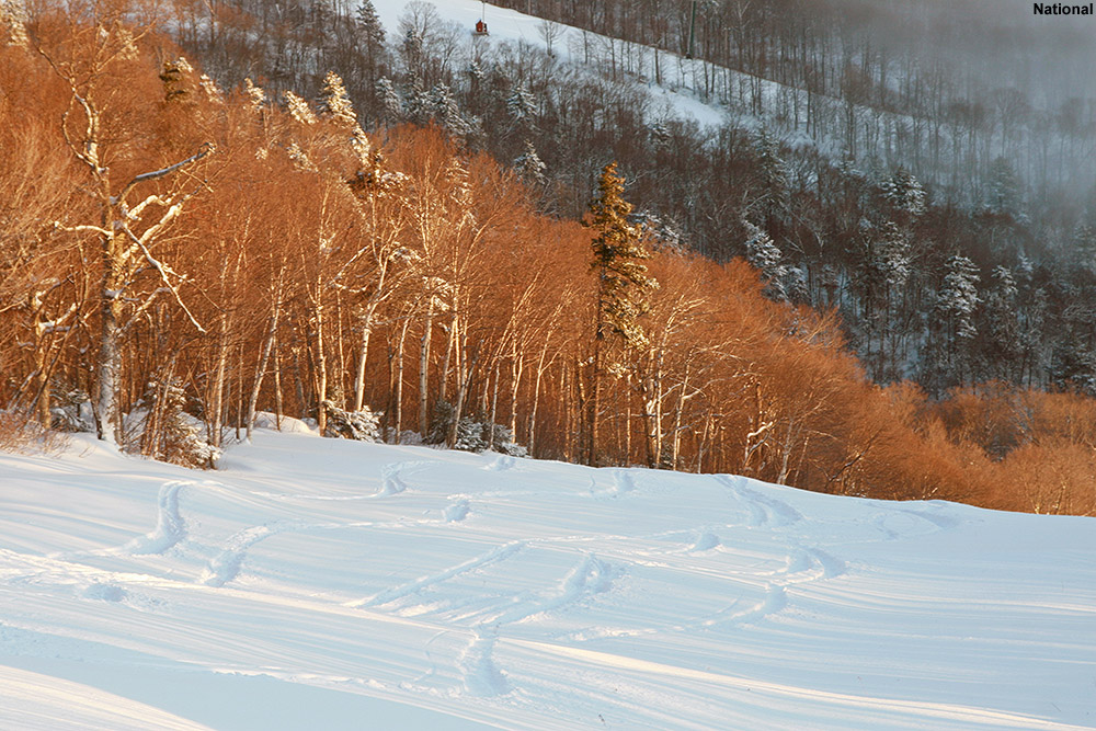
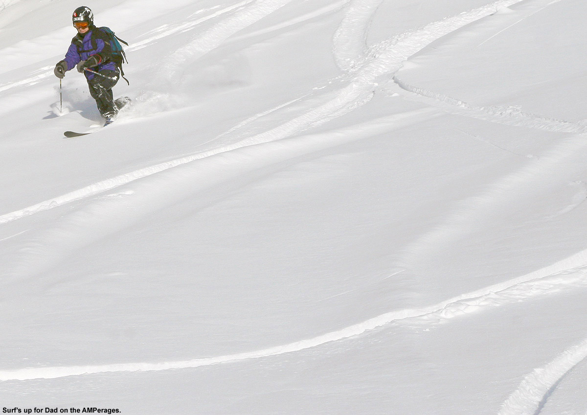
April: Despite the somewhat slow increases in the snowpack during the heart of the winter, the gains made during the latter half of March meant that the snowpack was at least modestly above average heading into April, and it quickly reached a peak of 87 inches at the Mt. Mansfield Stake when the first storm of the month dropped a foot of snow at Stowe on April 2nd. I was up at Bolton Valley that day for a ski tour, and I got to witness some impressive snowfall rates as the storm crashed into the higher elevations. The alpine terrain above tree line on Mt. Mansfield was in good shape, consistently providing excellent outings during that first part of the month. Cool temperatures with additional snow meant that the snowpack stayed at an above average level right through the month, and another storm on the 12th saw Ty and I enjoying close to a foot of dense powder out in the Bypass Chutes at Stowe on the 13th. The skiing gradually transitioned to full on spring conditions after that weekend as the active pattern waned, and an impressively long stretch of clear weather moved in and stuck around well into May.
May: For most of May, there wasn’t much to talk about in terms of new powder, especially with the extended period of incredibly clear weather that carried over from the end of April and lasted a fortnight, finally ending on the 10th of the month. There was some mighty fine spring skiing right through that period with all the sun and warm weather, even if it did cause the snowpack to decrease a bit faster than it otherwise might have. The tranquil period of warm weather allowed the Mt. Washington Auto Road to open on the 10th of the month as well (definitely on the early side), but since unsettled weather had just returned at that point, we didn’t get to make our spring pilgrimage to the snowfields until the 18th. To really cap the month off well, Northern New England and the Adirondacks were rewarded with a Nor’easter over Memorial Day Weekend, which delivered roughly 3 feet of powder to Whiteface and nearly 2 feet to Mt. Mansfield. Excellent powder turns were made while the valleys were almost fully leafed out for the spring. We didn’t actually head out for any June turns beyond that, but the skiing over Memorial Day Weekend had been so good that it hardly mattered – it was just a few short months until the snows of fall would be returning.
So what about the overall feel for the quality of the ski season in Northern Vermont? Well, much like the snowfall numbers suggest, it feels like it came in a bit below average, even if not horribly so. The mountain snowpack (as gauged by what was seen at the stake on Mt. Mansfield) had its ups and downs, and on balance it probably gets rated in a similar manner to what the slightly subpar snowfall would suggest. Being frequent Bolton Valley skiers and living down below the mountain in the Winooski Valley, our perspective might be skewed a bit downward with the resort receiving just 78.5% of their average snowfall. Having the north miss out somewhat on a couple of big regional storms, while watching a horrid valley snowpack (see the 2012-2013 Winter Weather Summary for details) that kept ski routes to the lower valley bottoms essentially off the table, certainly didn’t win the season any extra points. It seems that 2012-2013 ultimately sits in the lower half of ski seasons and won’t be remembered as anything epic, but it also appeared to hold onto a decent level of powder availability (77%) based on our experiences, and that means there was still a pretty decent amount of good skiing. The fact that even the poor 2011-2012 Ski Season was able to hold onto a powder percentage in that range is also reassuring in that regard, suggesting that there is indeed a certainly level of reliability that can be expected in these seasons where snowfall/snowpack is below average.
We’re pleased to announce the completion of our Bolton Valley Photo Gallery for the 2012-2013 ski season. This year’s gallery is our largest to date, with over 270 images documenting this season’s ski adventures indoors and out, in the front, side, and backcountry, under blue skies and flake-dumping maelstroms at Vermont’sBolton Valley Ski Resort. Continue on to the thumbnail images below and browse away! Detailed reports are associated with every photograph in the gallery, so if you find a scene that sparks your interest, simply hover over the thumbnail image to get the date, and head to the archives on the right side of the page to read the full report. We’ve also got similarly extensive galleries from the past several ski seasons, representing nearly 1,600 photographs from around Bolton Valley, and these can all be found at our J&E Productions Photo Galleries Page. We’ll also have our full 2012-2013 Ski Season Summary coming out later this summer, so stay tuned for that update as well.
Using the Auto Road to gain access to Mt. Washington’sEast Snowfields is a convenient way to get to some fantastic spring skiing, but a number of factors need to align for an optimal outing to come together. First, the road has to open. One never knows exactly when that’s going to happen, since it depends on how much snow has to be removed, how fast it’s melting, how much road maintenance needs to be done, how often bad weather delays work, etc. Then, even once the road is open, weather can still play a factor. Although some folks might be inclined to head up into the alpine regardless of the forecast, I think most folks would agree that a calm, warm, clear spring day (or at least as close as you can get to that ideal) is the way to go. Those types of days can be rare on Mt. Washington, but they certainly happen, and they typically occur more frequently the farther one gets into late spring. While time might be on your side with regard to weather, it’s generally not on your side when it comes to snowpack. With each passing day of warmth, the snowpack melts a little more, and ski options diminish. Unlike when you get an iceland camper rental over there, the snow isn’t lasting quite so long these days over here. And, even if the stars align to create that perfect combination of access, weather and snowpack on the mountain, there’s everything else in life that has the potential to get in the way of letting you jump at the opportunity. Once in a while, things just don’t come together before the snow melts, but somehow, even with all those obstacles, we usually manage to get over to New Hampshire for some spring camping and skiing with the boys, and this year was no exception.
“We had the snowfield to ourselves the entire afternoon…”
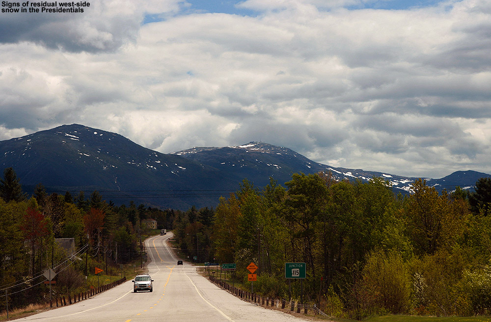
For two weeks from the end of April through to the second week of May, we saw an incredible stretch of clear, warm spring weather with absolutely no measurable precipitation at our house in Waterbury. This period produced some great spring skiing, but the warmth and sun also accelerated the snowmelt to a rate that was a bit faster than usual. This period was great in terms of progress on clearing snow from the Mt. Washington Auto Road however, and it was open to the summit as of last weekend. The weather was unsettled for that first weekend though, so we opted to head down to the South Shore area and visit Erica’s mom for Mother’s Day, and keep our eyes peeled for a good weather window. After a couple more days of unsettled weather, the clear regime returned this week, and prospects for an Auto Road trip were looking excellent. This morning, the forecast called for decent weather with temperatures in the 40s F, and the morning shot from the Ravines Cam revealed crystal clear skies. It also showed that the east side ski options below the Mt. Washington summit are still quite plentiful, with many additional snowfields available along with the main one.
Presidential view
We were on our way to the mountain by mid morning, and views from the west side were already encouraging as we approached the Presidentials. When the west side still has skiable snow, you know the east side is going to have plenty of options. Steep lines with decent snow were even visible on the north side of the range as we passed by on Route 2, and on the ascent of the Auto Road we could see various snowfields in the peaks towering above the Great Gulf. In the proximity of the Auto Road itself, the first signs of snow were at roughly the 3,500′ elevation. As for the East Snowfields, the setup today was a lot like we encountered during our 2010 trip, in that the broad strip of snowfields was present off to the north of the main East Snowfield. A look at the availability of snow in 2010 shows an interesting distribution of snow – that strip of snowfields off to the north was very prominent, and the main East Snowfield was surprisingly small. The current snowpack is definitely different from what we had available on our 2011 and 2012 trips, where the skiing was essentially down to just the main snowfield.
“The snowfield held
beautifully flat and
pristine corn snow…”
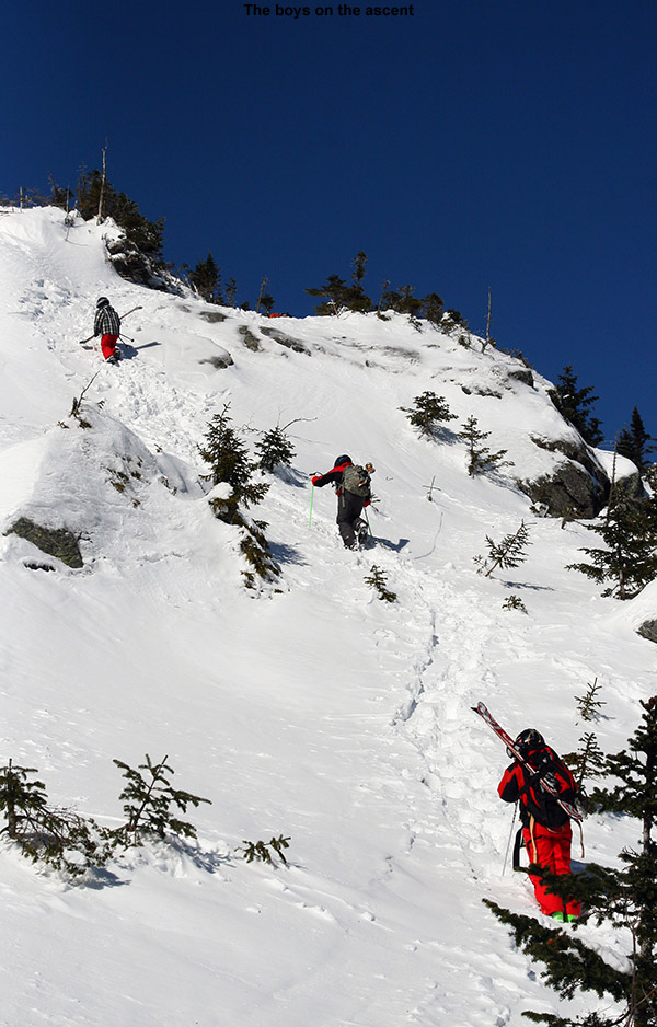
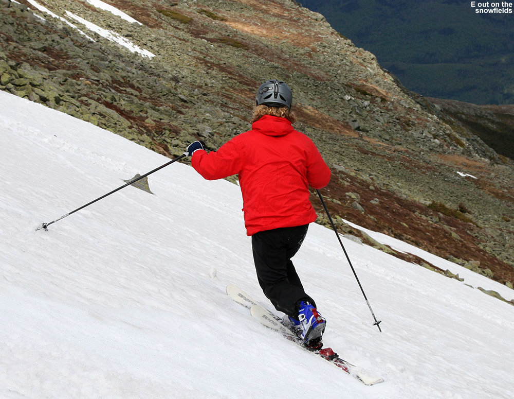
With the lower snowfields in action, we decided to go with the approach applied in our 2010 trip, which is to use the parking area below the 7-mile post on the road, instead of the parking area at the top of the snowfields. Using this technique, one can tour out along the more northerly snowfields as far as they want, even hitting the main East Snowfield if they’d like. Then, to finish the tour, instead of having to hike back up to the parking area atop the East Snowfield, one can essentially traverse back along the base of the snowfields with minimal additional ascent. Along the way, you can make descents in the other snowfields as well, which often have untouched snow. They’re used much less than the main East Snowfield and we’ve typically found that we have them to ourselves with untouched corn snow. At the end of our 2010 trip, we also discovered a very efficient use of the mountain’s hiking trail network for this type of tour. We’ve started traversing on the Nelson Crag Trail before, but, it turns out that simply descending straight down from the lower parking area on the Huntington Ravine Trail drops you right onto the northern edge of the snowfields, so you can use the trail to get you right to the snow. You can’t really see the snow from above, so it’s not obvious unless you know what you’re doing, but as long as those northerly extensions of the snowfield are present, it’s a really sweet and efficient approach. Even though the distribution of the snow in the snowfields area is different each spring, it’s nice to be developing a knowledge of what works well for getting to the snow. We’re definitely starting to dial in a good understanding of how to best approach what we see on the Ravines Cam in terms of touring the snowfields. This year our goal was to tour out toward the main East Snowfield as described above, with the potential to ski there, but it would depend on how good the skiing was that found along the way, as well as time, and of course the boy’s attitude and morale, which can be extremely flighty on these outings.
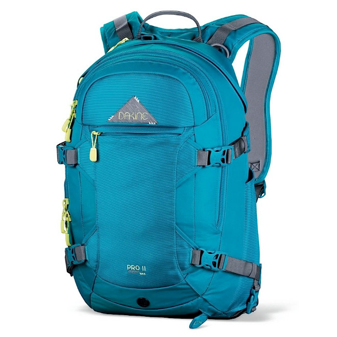
As expected, taking the Huntington Ravine Trail got us to the snow in just a few minutes of hiking from the car, and Ty and Dylan were ready to just stop right there and start skiing. E and I explained to them that what they saw was just the tip of the iceberg in terms of snow, and that we would be traversing southward for some longer lines. The snowfield there was only about 50 vertical feet or so, but typically the priority for the boys is to minimize the amount of hiking they have to do in whatever way they can. The boys did have a bit more challenge this year, since they were both carrying their own skis on their packs for the first time. Fortunately, they had both decided to use their Telemark skis, also a first for them, so it’s nice that their Teles are lighter than their alpines. This also meant that they could simply wear their Telemark boots and hike like me and Erica in ours, since they are very flexible and have rubber soles. This meant we didn’t have any alpine boots to carry, although Tele boots still aren’t quite as easy for hiking as standard hiking boots, so that was a bit of a bump in challenge for the boys. For E, this trip was also a chance to carry her skis on the Dakine Women’s Pro II 26L ski pack that she got for Christmas. Although she used it on some backcountry outings this winter, we were always skinning, so there was no need to carry her skis on her back. This was her first opportunity to really put it to the test with skis on it, and she was very impressed. I wouldn’t have thought about it, except that she commented on how it didn’t even feel like she had skis on her back – that’s always good sign when it comes to a ski pack. She also mentioned how the diagonal carry is so superior to the A-frame style carry in terms hitting the backs of the skis with your legs. I’ve always been very impressed with the diagonal carry on my Dakine Sequence ski/photo pack, so I’m glad E is getting to make use of that system. Dakine definitely knows how to set up a ski carry system. The one issue I did notice with E’s pack is that since it has a helmet carrying system (very cook and I wish I had one) it gets a bit tight when the skis are on there in diagonal carry as well. Overall the skis and helmet were nice and snug there though, and E had no complaints. Our only lament heading outbound on the tour was that with our skis angled down to the right, it meant that they occasionally touched the rocks because of the direction of the side slope on our southward traverse. It was only an occasional inconvenience though, and I joked that we could always traverse around the entire Mt. Washington summit cone in the other direction if we really wanted to avoid that issue ;).
Time to hit the snow!
After only about ten minutes of southward traversing, we came to a substantial snowfield of about 250′ vertical or so, and we decided to do some skiing. We hit the snowfield about midway up, so I set in a boot ladder to the top. The snowfield held beautifully flat and pristine corn snow, aside from a couple of very faint tracks from a previous skier or two that must have been there quite a while ago. The snowfield was continuous, but did have a choke point about midway down along the left, so one had to take that route.
It was good that we’d reached at least an initial snowfield, because the boys were already getting grumpy. They really wanted to get on with the camping. They’d been planning that aspect of the trip for a long time, looking on sites like campingfunzone.com for handy tips and tricks which they were now dying to try out, so while they enjoy being out on the snow, getting them to thoroughly relish all aspects of earned turns is always a challenge. They got out their flashlights for hiking when it got dark, and loved the setup and maintaining the fire, and other tasks like that. Some days they enjoy the experience, or at least substantial parts of it, but other times it’s essentially putting up with Mom and Dad dragging them around to these snowy spots. We’ve learned that it’s good to have a “carrot” aspect of the trip as well, whether it’s a stop in a the Bryant Cabin on a Bolton Valley Backcountry Network outing or the swimming pool after, a chance to eat out somewhere once we’re done, or in this case, a chance to do some camping. We relayed to them that they were sitting on their own private snowfield with great temperatures, no wind, no bugs, beautiful snow, and even some sunshine. These aren’t things that you can get every day, but in their minds they were already off the mountain and down by the tent and campfire.
Getting after some of that smooth corn snow today
At the top of the snowfield, I hung out for a while and enjoyed the scene, while the boys did a bit of sliding on the snowfield, and E made the first descent. Her turns looked good, and it was amazing how fast she dropped that vertical. It seemed like she was down toward the flats of the Alpine Garden area in an instant, and she looked so far away. I skied a run next, and then we eventually got the boys to make some turns, even though they were being somewhat lazy and reluctant. They both put together some nice Telemark turns, even though the pitch of the snowfield was quite steep. E and I both made some additional turns, with me finishing off a run on the lower right of the snowfield while E shot some pictures. We had the snowfield to ourselves the entire afternoon, so even though it was only about half the vertical of what was available on the main East Snowfield, it was such good skiing that we never even continued over there. The boys were a bit too sour for that anyway, and really wanted to get on to the camping. We could hear that occasional shout from people on the main snowfield though, and I’m sure there were some great times going on over there.
Dylan out there carving some turns on the Telemark skis
The return traverse to the car was pretty quick, and E and I helped out the boys by each carrying a pair of their skis. For the extra set of skis, we went with a vertical carry, and E seemed to still be impressed with the stability and ease of her pack, even with the second set of skis on it. I made the lowest traverse, so that meant a few minutes of hiking back up the Huntington Ravine Trail at the end, but I was eager to test that out. It was nice to walk on an established trail, since the going was a big quicker than across the random jumbles of rocks that give the Rock Pile its name. While we were loading up the gear at the parking area, we had some inquiries about where we’d been skiing, and one guy was very intrigued to know that you could access the snowfield from that lower parking lot. He said he’d like to try it out in the future.
“…but in their minds
they were already off
the mountain and down
by the tent and campfire.”
Each year we like to try out a new campground on our visit to the snowfields, and this year I decided that we’d head south to Glen, New Hampshire. I’d found a couple of potential campgrounds there. The first was the Green Meadow Camping Area, but when we stopped in and found out that they weren’t opening until next weekend, we headed to the Glen Ellis Family Campground a couple of miles down the road. I’d put it as the second choice because it was a bit more expensive, but once we got there you could immediately tell why. The grounds are immaculate, and the building that functions as the main office and store was a beautiful building. Everything was first rate, and they’ve got a huge playground, basketball and tennis courts, and even a pristine baseball diamond. It’s certainly in that upper echelon of campgrounds.
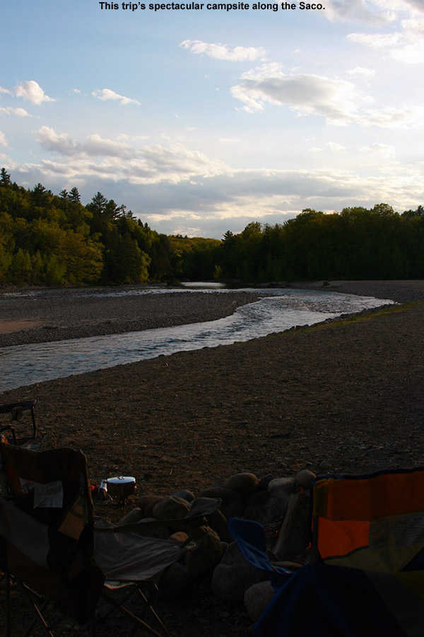
Visitation was only modest since it’s no Memorial Day yet, so they gave us one of the riverside campsites. We thought that would be nice, but it wasn’t until we finally got to it that was saw how amazing it was – it was absolutely one of the coolest campsites we’ve ever had in either to Eastern or Western U.S. There’s a wooded section with the usual fire ring, picnic table, etc., but then that expands up onto a riverside area comprised of the rocks that are part of the riverbed, with a second fire ring. It overlooks a gorgeous stretch of the Saco River that made E and I feel like we were back in Jasper National Park. As soon as we saw that riverside section, we knew we were going to pitch our tent right up there. The boys headed off to the playground for a bit, we cooked up some hot dogs and beans for dinner, and finished things off with s’mores and lot of campfire time. There wasn’t actually anyone else camping out on the river since campground visitation was light, but I have to believe those riverside spots are pretty coveted on busy weekend. The fly fishing looked amazing, and we saw one guy out working the stream about a half mile downstream. That is a campsite that will not soon be forgotten, and it will definitely be on our list for the next time we’re in the area. Apparently their Laundromat is a big deal as well, because there are as many signs for that as there are for the campground itself!
The view from our campsite at the Glen Ellis Family Campground today
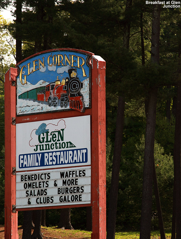
Sunday update: The evening sky had some on and off broken clouds and a nice moon, and I bet it dropped into the 30s F overnight because even with the rain fly on the tent, we were down to the mid 40’s F. After breaking camp, we decided to try out one of the local restaurants for breakfast on the way home, and found the Glen Junction Family Restaurant. It definitely seemed to be the hot spot for breakfast, and the menu was almost overwhelming with the variety of combinations of fresh toast, omelets, and most of the usual morning fare that you can think of. Not surprisingly with the junction location, the theme is trains, and they’ve got some fairly large-scale trains that circulate around the rooms up near the ceiling. The boys definitely enjoyed watching those, as did the numerous children that were there as well – especially the younger ones. Of course any adults like me would enjoy them as well. One of the specials had eggs Benedict on French toast, which was tempting, although I ended up making my own omelet which contained corned beef hash and spinach. The waitress said that was the first time she’d ever had anyone put together that specific combination, and it turned out great. Everyone liked their fare, and we even had some extra to take home as the portions are plentiful.
We got home today around noontime, after a bit of maintenance on the mowers, I was able to do the first lawn mowing of the season. It’s only about four short months until I’ll be on the last mowing of the season, and we’ll be thinking about the first snows, but there are plenty of summer activities to do in the meantime. In terms of skiing, we’ll have to see if we want to take a trip down to Killington for some turns in the next couple of weeks, since they’re apparently going for June this year just like old times.


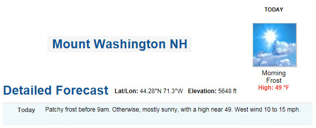 I did a final check on the forecast for roughly the 5,500’ level on Mt. Washington this morning, and it called for leftover frost, clear skies, a high around 50 F, and light winds in the 10-15 MPH range. That’s an excellent forecast for some skiing in Mt. Washington’s alpine areas, and it’s good to jump at these sorts of days, because you never know what the next one will bring when it comes to the Mt. Washington and the Presidential Range. The boys and I headed out around 9:00 A.M. under blue skies and temperatures in the 60s F, and by midday we were up in the parking lot along the Nelson Crag Trail at ~5,700’ getting our gear together. The weather was great, and the numbers on the board showing the summit weather conditions had been right in line with what the forecast suggested. After checking the images from the Ravines Cam over the past few days, as well as this morning, I could see that one of our favorite snowfield areas below Ball Crag was of decent size, so that was our planned destination. We like that Ball Crag snowfield because it doesn’t see nearly as many visitors as the main East Snowfields below the summit, and instead of having to park above it and hike down into the snow, you can contour right across from the parking area along the Nelson Crag Trail. It can be a bit harder to find some of those lower snowfields if you’re not familiar with the area, but we usually have good luck traversing out from near the junction of the Nelson Crag and Huntington Ravine Trails.
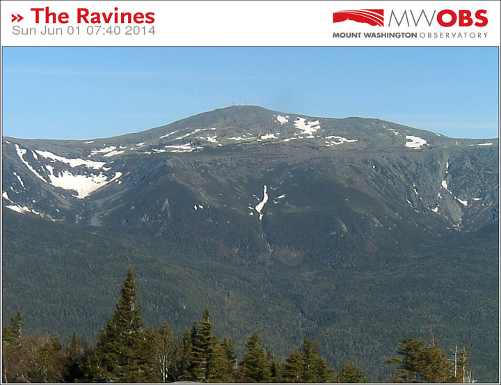


")


