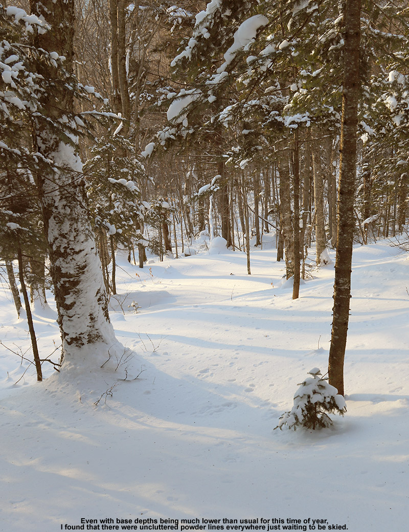
Out on the Burt Trail today for some backcountry skiing
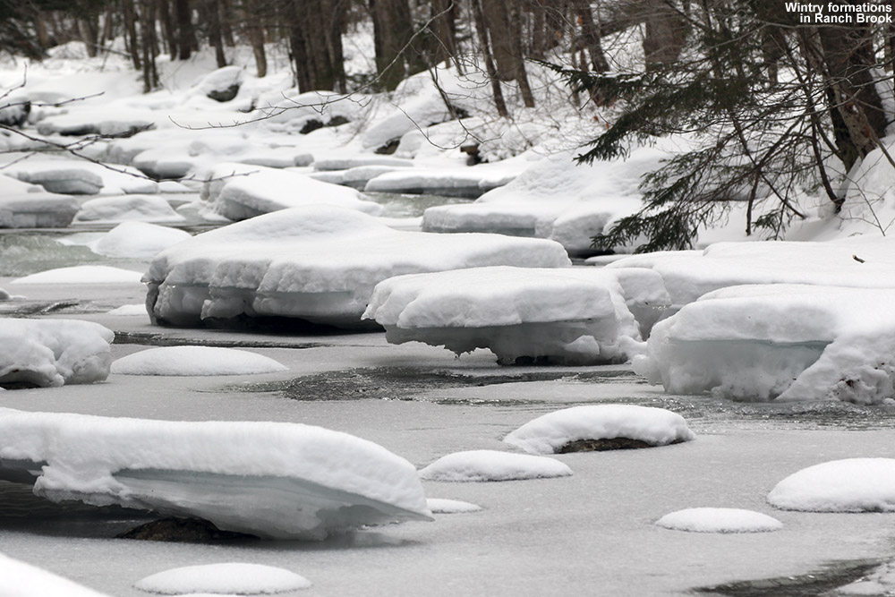
It’s been a relatively slow week for snowfall in the Northern Greens, but Stowe did manage to pick up roughly a foot of snow between Wednesday and Thursday. Since the Mt. Mansfield area seemed to be a sweet spot with respect to snowfall, I decided to head out for a backcountry tour in the Ranch Valley, which sits just to the south of the resort’s alpine trail network and is the location for Stowe’s Cross Country Center. I’ve been through the area numerous times when coming down the Bruce Trail, and I’ve sampled some of the natural glades that populate the middle elevations in that area. I could see that there was much more skiable terrain to explore though, so I decided to check out what the areas around the Burt Trail had to offer.
Temperatures were in the low to mid 20s F in the local mountain valleys as I headed up to the Stowe Cross Country Center to start my tour. It turns out that Mrs. Blanck was behind the counter when I was buying my trail pass, so we were able to catch up a bit and she gave me an overview of some nice glades that she’d heard of as we reviewed the backcountry portion of the trail map.
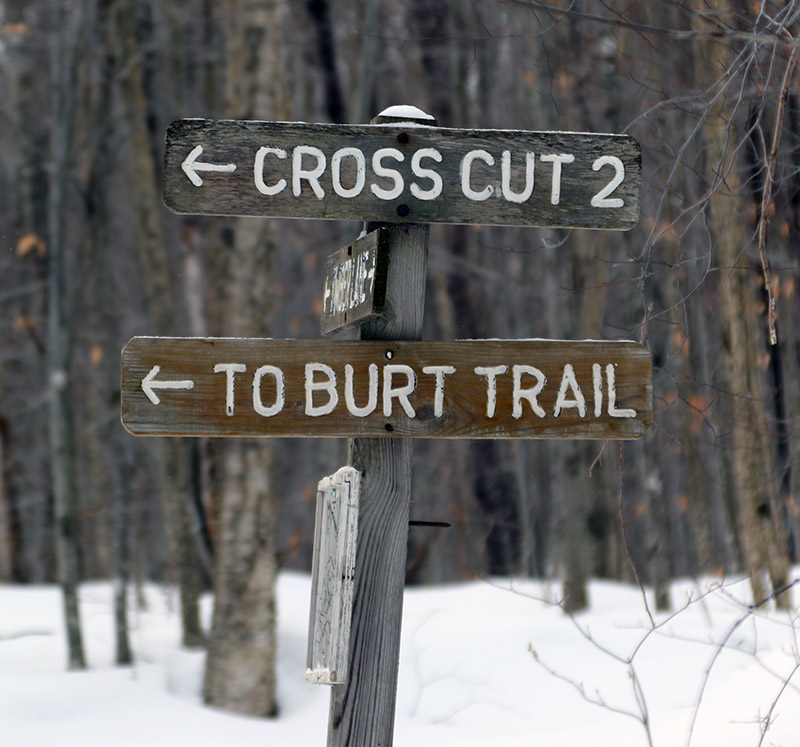
My ascent route consisted of starting on the Timberlane Trail and using Cross Cut 2 to get to the Burt Trail. The recent snows were certainly elevation dependent, so there was only about an inch of fresh snow atop the snowpack down near the base of the Cross Country Center at ~1,000’. It did increase as I ascended, reaching a couple of inches by the time I hit the Burt Trail, and nearly 4 inches at the top of my ascent at the junction with the Underhill Trail. Here’s the general depths of surface powder I found on my tour with respect to elevation:
1,000’: 1”
1,500’: 2-3”
2,000’: 3”
2,500’: ~4”
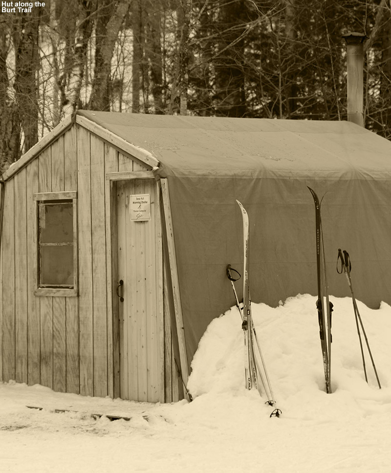
Passing a hut along the Burt Trail
The backcountry portion of the Burt Trail starts right around 1,500’ elevation, and getting to that point represents a pretty hefty approach of over two miles, so that’s about the minimum distance one will have to go on this route to get into terrain for potential descents. The Burt Trail really starts to steepen above 2,000’, which one hits at close to three miles in. At that point it’s comprised of switchbacks to accommodate the steeper terrain. That area is still mostly hardwoods, with scattered evergreens, so tree density isn’t too bad and one can easily cut the switchbacks and ski through the forest. That terrain is pretty steep though, so one would want a decent amount of powder for it to be optimal. Based on darkness and trying to ensure that I made it back to the Cross Country Center by 5:00 P.M. since a sign that the parking lot gate would close at that point, I only ascended to the junction with the Underhill Trail, but I could see that there was plenty of similar terrain right up above me.
As for the skiing and conditions, one would definitely want more powder above the base than what I found today, but I was still able to get in some decent turns. I had my midfat Tele skis, which were certainly not all that light in the overall spectrum of Nordic equipment, but I was thankful to have something that could handle the descent well. I cut the Burt Trail switchbacks and skied the fairly open forest in some spots, but I could actually stay on the trail itself for the most part where it mattered. Only one person had gone up ahead of me above 2,000’ on the trail and they must have descended another way, because there was no descent track. So the Burt Trail itself was relatively untracked and I got some of my best turns of the afternoon simply by staying on it. The terrain in the 1,500’ to 2,000’ range offers some options off the trail depending on the pitch of the terrain, but I just ran my descent out the trail itself based on the snow conditions and my time. The whole runout back to the Cross Country Center is actually pretty fun, and you can really cruise along at times, but you will have to do some skating and deal with a couple of small uphill sections. It’s quite similar to running out the Bruce Trail though, and indeed the route is identical in some spots, so if you’ve done that you’ll have a good sense for what this is like.
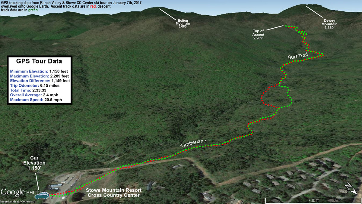
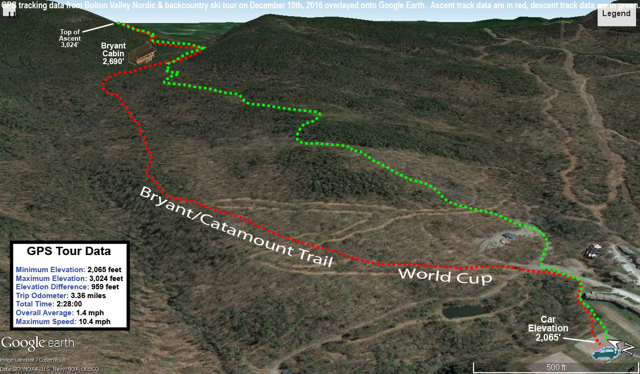
Today’s backcountry ski route in the Ranch Valley
It looks like we’ll be in a fairly active weather pattern in the foreseeable future with some clipper-type events and larger synoptic systems with potential mixed precipitation, so we’ll see how these play out in terms of bolstering the snowpack.
In the backcountry today, the higher elevations held up to 20 inches of powder atop a roughly 10-inch base, indicating a snowpack of approximately 30 inches.
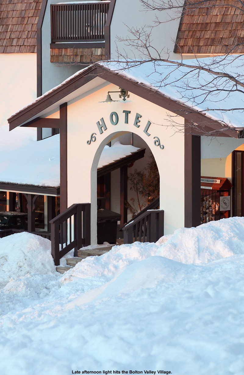
This is opening weekend for lift-served skiing at Bolton Valley, but with only minimal terrain served by the lifts at the moment and fairly chilly temperatures in the forecast, I decided to make it my first visit of the season to the Bolton Valley Backcountry Network. Although we haven’t had any big storms in the area in the past few days, we’ve had some lake-effect snow from the Great Lakes and additional snow from an arctic frontal passage that has given the mountains additional bouts of snow almost every day. The Mt. Mansfield Stake is indicating a snowpack depth of 34”, and it’s definitely not just fluff. With the high elevation and maintenance that goes on in the Bolton Valley Backcountry Network, I’ll usually feel OK poking around on appropriate terrain once the stake kits 24” (depending on the composition of that 24”), so with 34” I figured it would definitely be ready to go.
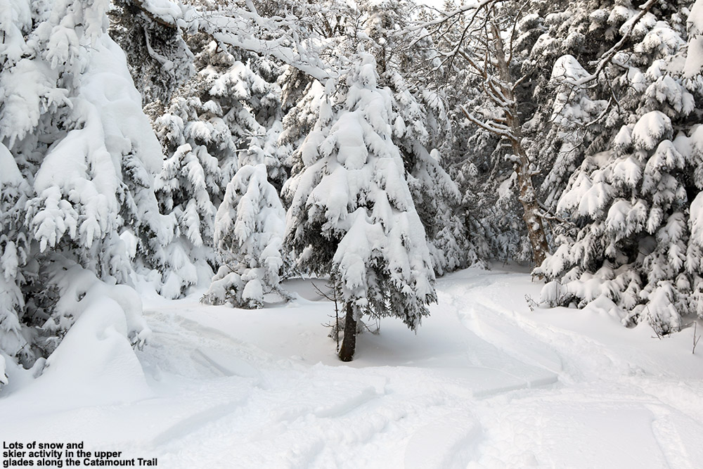
I headed up to the mountain in the afternoon, and temperatures in the Village at ~2,000’ were in the mid-teens F, but fortunately there was minimal wind. There was blue sky at times, but light snow was still falling off and on. My goal was to head to the upper glades along the Catamount Trail out past the resort boundary. Those glades are up around the 3,000’ elevation, so I suspected the snowpack would be more than sufficient.
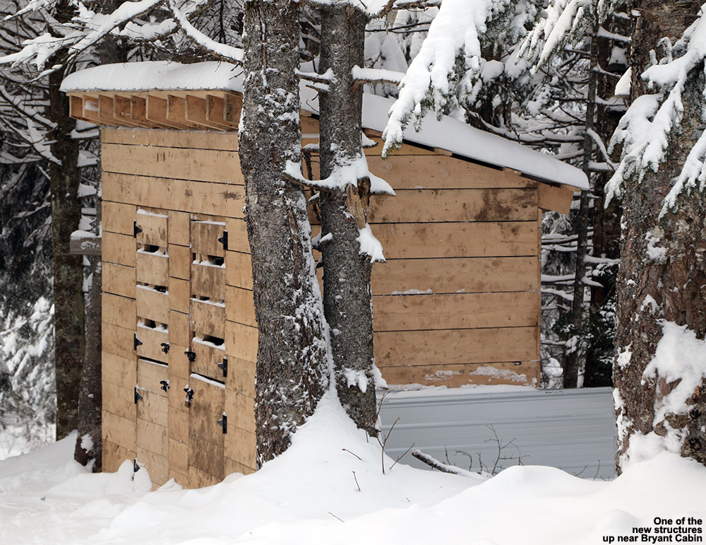
I saw that there had been some recent construction up in the Bryant Cabin area.
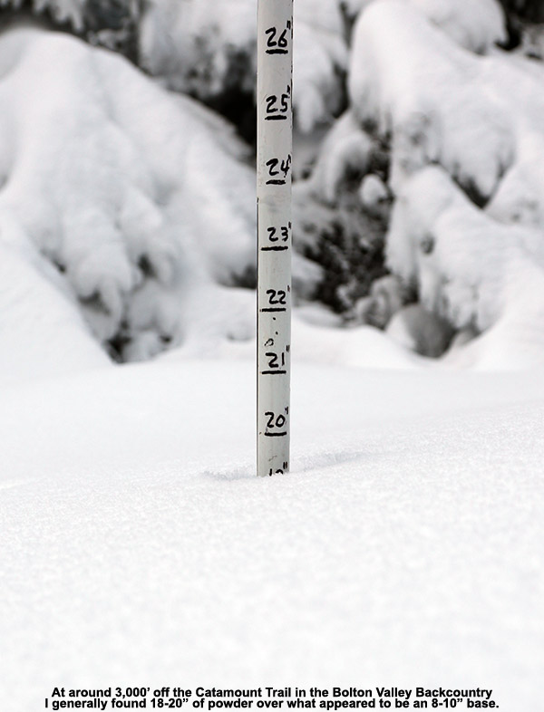
I headed up the usual Bryant Trail, and the most interesting thing I saw was that there are some new structures going up around the Bryant Cabin. One structure looked like a shed of sorts, and there was a larger structure that seemed to be partially built. It also seemed that there had been some work done on the cabin itself. In terms of snowpack depths, down at the Village at 2,000’ the surface snow was generally 14-15” of powder over a fairly thin layer of base snow. Up at the Bryant Cabin at ~2,700’ there was 16-17” of powder over a much more substantial base, and when I finally got up to ~3,000’ in the glades on the back side of Bolton Mountain there was a healthy 18-20” of powder. I was able to punch through the base at one point in my measurements, and the base snow seemed to be in the 8-10” range. So, that would put total snowpack depths up at that elevation approaching the 30” range, which seems pretty reasonable with the Mt. Mansfield Stake at 34”.
“…when I finally got up to ~3,000’ in the glades on the back side of Bolton Mountain there was a healthy 18-20” of powder. I was able to punch through the base at one point in my measurements, and the base snow seemed to be in the 8-10” range. So, that would put total snowpack depths up at that elevation approaching the 30” range…”
The skiing was generally excellent, especially in those upper glades. Since it was afternoon there had certainly been some traffic up there, but I still found areas of fresh snow. I made my way down via Gardiner’s Lane, and eventually decided to check out the Alchemist glade that I hadn’t visited in a while to the south of Gotham City. It’s a south-facing glade, so conditions can be quite variable, but aspect almost doesn’t matter right now because we’ve had November/December sun over the past couple of weeks… and not much of it anyway, so south-facing terrain isn’t all that different from north-facing terrain. One does have to watch out as they get down near 2,000’ though because the base below the surface snow does start to get pretty thin, so you don’t want to ski anything with many obstacles at that point. One could easily just lap terrain up above 2,500’ though with minimal concern about base depths. Skiing is definitely quite good up high right now.
GPS/Google Earth plot of today’s backcountry ski tour at Bolton Valley
There was a bit of accumulation of snow on my car when I got back to it after the tour. It was rather minimal though, about ¼“ of new after 2 to 3 hours away. Currently, Winter Weather Advisories are up ahead of our next storm that is coming into the area tomorrow. I signed up for Washington County weather alert texts through VT-Alert, so I was notified of our Winter Weather Advisory just I was finishing up my ski tour today. It was definitely nice to get that heads up right away without having to actively check, and it really doesn’t matter where you are. Anyway, the advisory calls for a general 4-7”, which seems pretty consistent with what’s been expected of this event for a few days now.
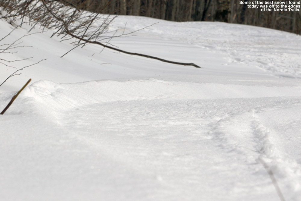
Catching a little powder off to the side of World Cup on Bolton’s Nordic trails.
It’s not too often in Northern Vermont that we have winter temperatures and no access to powder, but today was pretty close. Generally, even for winter weather systems with mixed precipitation, there’s at least some snow on the back side of the storm to provide a bit of powder for skiing. As usual, that was the case with Winter Storm Quo that came through earlier this week. The storm dropped 4 to 5 inches on the resorts in the Northern Greens, and the precipitation even remained frozen throughout the event. After the dense accumulation in the middle of the storm, there was some lighter powder, but it was fluffy, and based on the way it has really settled down over the past couple of days here at the house, I suspected things would be similar up in the mountains.
With that in mind, I inquired with E and the boys to see if any of them wanted to go for a ski tour up at the mountain, but didn’t push too hard because I didn’t suspect the conditions would be quite up to the level of what we found last Saturday on the Bolton Valley Backcountry Network. It was a nice sunny day though, with temperatures around the freezing mark down in the valley, so whatever the conditions, it was going to be nice to get out in the fresh air.
Temperatures were in the mid to upper 20s F up at the resort, and it looked like business was good based on the number of cars in the Village lots. Although Winter Storm Quo didn’t deliver a ton of powder, it did substantiate the base depths at the resort, and the open trail count was as high as it’s been in a while. I hopped onto Broadway and headed right up toward Bryant Cabin. The powder had settled to about a half inch at Village level, and I was hoping that it would build with elevation the way it had last weekend, but it never really did. Even up at the cabin I only found about an inch or so of fluff above the base. The overall minimal availability of the powder skiing was pretty evident due to the fact that I saw more people out on the trails today on snowshoes vs. skis.
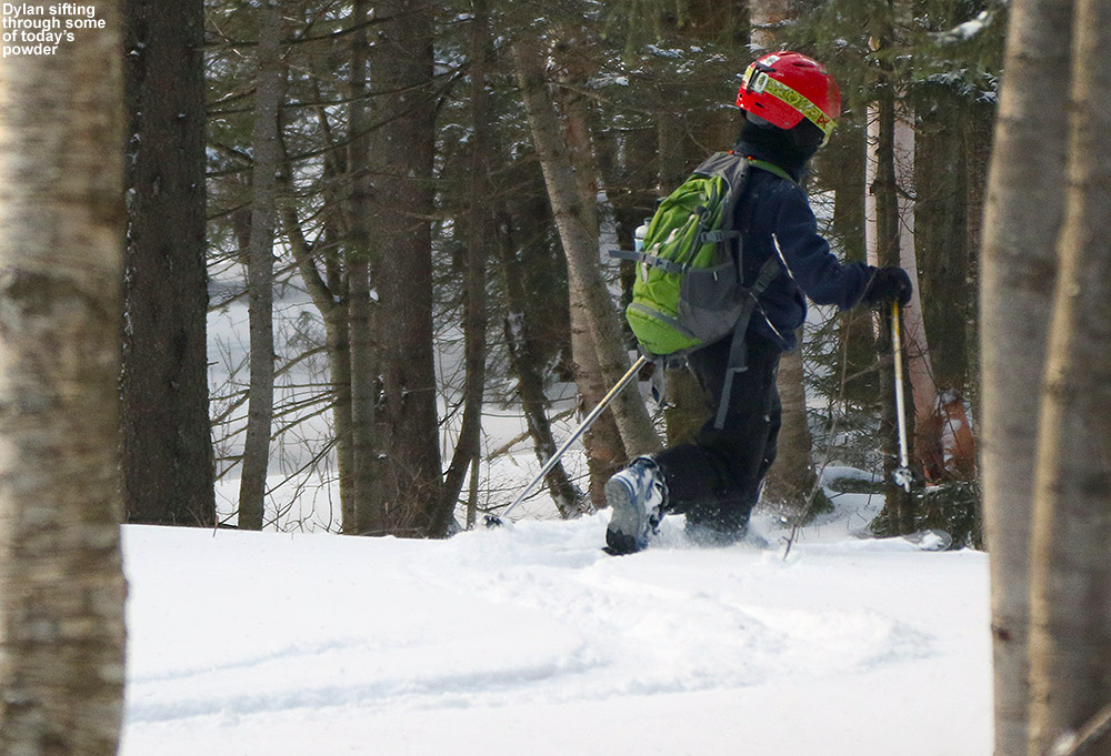
Noting the minimal powder, I decided that I ski some of the mellow trees between the Bryant Trail and Gardiner’s Lane. The skiing was surprisingly good because thanks to little if any liquid precipitation, the base below wasn’t really icy, it was mostly just dense. The turns there got me interested enough that I headed off toward North Slope to check out some of the glades there. I tried out a new area back down to Gardiner’s Lane, and then poked around in the trees and found some new glades in the A1A area that I don’t think I’d skied before. They brought me right down to the junction of Bryant and Coyote, where I skied Coyote out to World Cup and connected over to the base area. I had some good turns here and there, with some nice ones off in the untouched snow off to the sides of the groomed Nordic trails.
A map of Bolton Valley’s Nordic and Backcountry Network with more than two dozen glades listed.
Back in the Village I grabbed some food for E and the boys and called it a day. Over the next week it looks like we’ll have some spring warmth and sun moving into the area, but the weather models do show the potential for some storms, so we’ll have to see if they bring some snow to the mountains.
Temperatures at the house were in the low to mid 30s F when we headed up to the mountain in the midafternoon timeframe, and it was just a bit below freezing up at the Village (~2,100’). It’s not quite spring weather yet, but the sun is certainly getting stronger, and it was pleasant as we put our ski boots on down along Broadway in one of the tennis court parking areas.
Depth checks at the start of the tour revealed that the new powder had settled to about 2-3” down at the Village elevations, and up at Bryant Cabin it was in the 4-5” range. The Bryant Trail was pretty quiet and we didn’t see anyone else, but you could tell by the various descent tracks and a well-established skin track in spots that people had certainly been out. Up at the cabin we stopped to have hot chocolate that E had made (with a special thermos of dark hot chocolate for Dylan that he was very excited about).
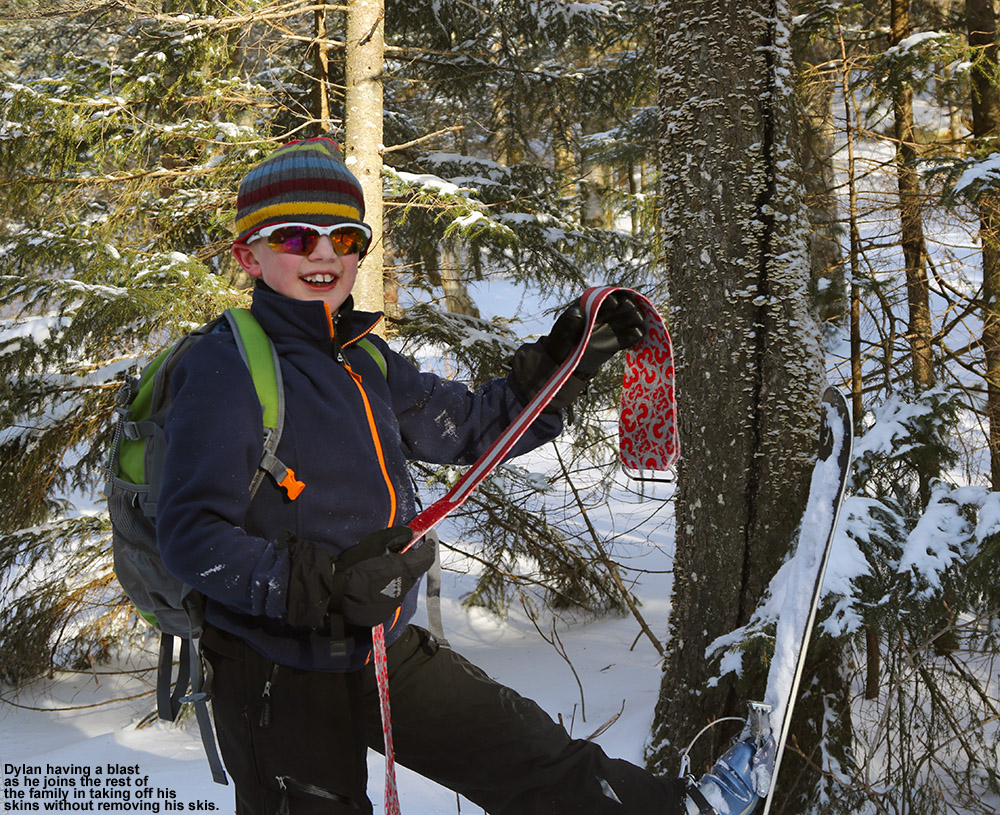
Everybody had a fun time working on skin removal without taking off their skis today.
I took everyone on one of my usual routes along Gardiner’s Lane, North Slope, and then down via Grizzwald through Gotham City. We skinned a bit past the cabin, and at the top of our descent everyone worked on removing their skins without taking off their skis. Everyone was ultimately successful, although I’d say Ty spent a good amount of time on the ground after things went a bit awry. We caught first tracks in some areas, and on the upper half of the terrain the powder turns were quite nice. I kept everyone off south facing terrain since I could see that it was pretty thin, but in fact I’d say this has to be the lowest snowpack that I can remember around here for the end of February. Fortunately that amount of snow is still enough to cover a lot of the glades well. Below Gotham City the snowpack and powder were notably thinner, so you had less line selection, but we still had some good turns down there. No doubt the way to go for the best turns is to stay above ~2,400’ if possible right now, but you can get some very nice powder if you know your terrain and aspects. It was really great to get the whole family out for some exercise today, since we haven’t had quite as many ski outings as usual with the low snowfall this season. The boys were in good spirits for the whole tour, I’d say probably the most positive backcountry attitude from them in quite some time!
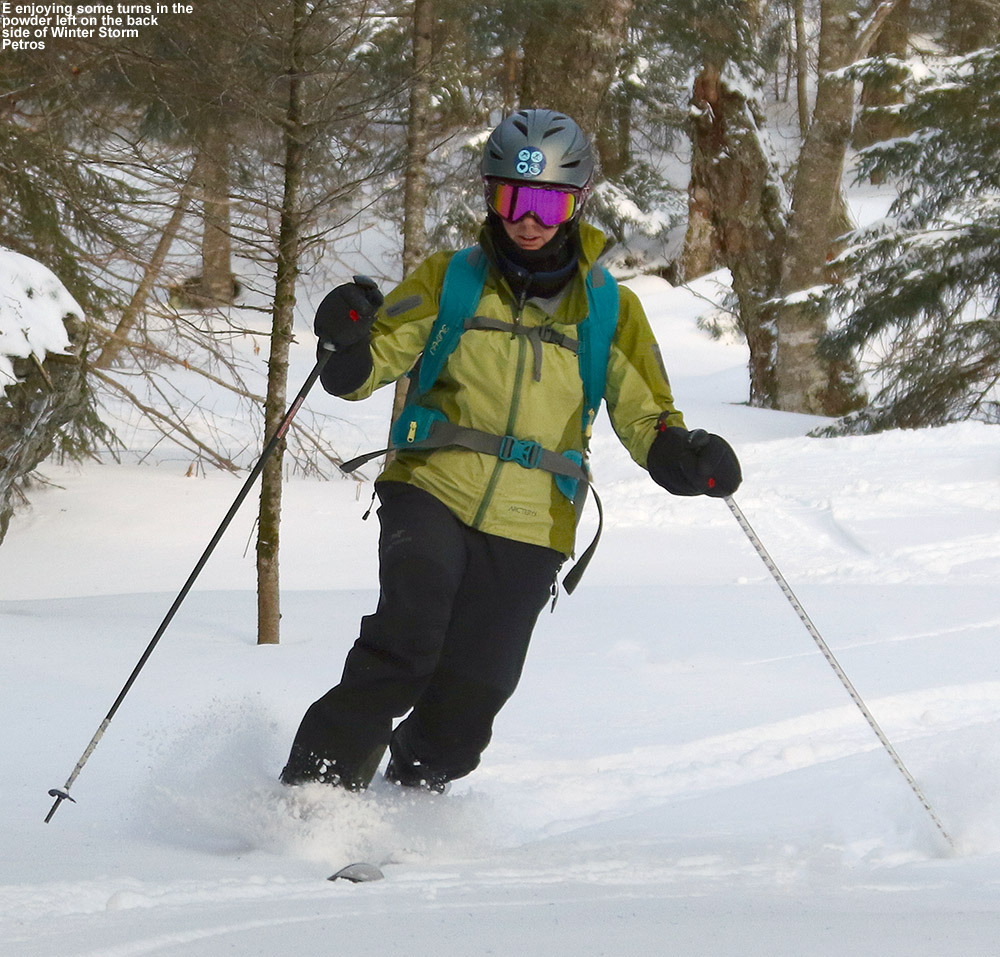
E Teles through the powder today as we drop through one of the glades below North Slope
We’ve got another system in the area tonight giving us a bit of snow right now even here at the house, but it sounds like Jay Peak might really get the best shot out of this one.
The snowpack may be low for this time of year, but you’d never know it based on the great powder skiing I found today on the Bolton Valley Backcountry Network.
I was busy with a bunch of work at the house today, but with the recent powder, a solid base below it, and afternoon blue skies with temperatures in the 20s F, it was just too nice of day not to get out. I decided to head to the mountain for a quick backcountry tour up to Bryant Cabin and down through some of numerous glades below it. The resort was really hoppin’ with visitors, and with the gorgeous afternoon and people probably making up for lost ski time during out slow December, it wasn’t surprising. Fortunately, I was quickly able to get a parking spot right along the Nordic trails in one of the tennis court lots.
I got on my way and checked the depth of the powder at Village level. Bolton Valley had reported 18 inches from the storm in their higher elevations, and I found that settled powder depths today at ~2,000’ were 10-12 inches. I could see that coverage was excellent as I skinned my way up the Bryant Trail; there really aren’t any concerns about bare spots on the main routes at this point. Up at the cabin at ~2,700 I found that the depth of the powder had bumped up a couple of inches to the 12-14” range. It was a gorgeous time to be out on the trails in that last hour before sunset, and I saw a few other Nordic and backcountry skiers out there enjoying the scene as well.
“I’ve got to say, you know the Northern Greens are a pretty sweet spot for snow when we’re currently running in the bottom 5% of ski seasons on terms of snowfall, and there’s still plentiful base and powder for midwinter-quality powder skiing.”
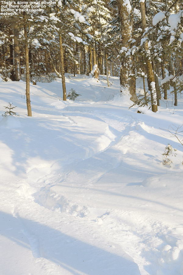
I took a descent route through several of my favorite glades in the North Slope/Gardiner’s Lane area including Grizzwald and Girl’s, others that I’m not sure of the names, and still others that I don’t think have names because they’re likely just areas of the forest that are naturally appropriate for skiing. The powder turns were fantastic; the base is plenty deep and the amount of powder for even blue and black pitches was plenty for bottomless floatation on my fat skis. I’ve got to say, you know the Northern Greens are a pretty sweet spot for snow when we’re currently running in the bottom 5% of ski seasons on terms of snowfall, and there’s still plentiful base and powder for midwinter-quality powder skiing. I suspect the very steepest terrain is probably not quite there yet in terms of coverage, but from what I skied, you’d almost never even guess that snowpack is only in the 2 to 3-foot range. The only hints I had that things weren’t quite at the typical Northern Greens midwinter depth were those instances where you might feel a slight pressure/bump where a log sits under the base, vs. never even knowing it exists. In any event, the Bolton Valley Backcountry Network is in great shape, so get out and enjoy it. There’s certainly something to be said for having the base elevation above 2,000’.
I really didn’t find much underbrush on a lot of powder lines today; they were looking in midwinter form.
I managed to catch fresh tracks through various glades and tree areas all the way down to the bottom of World Cup, and then skied out and hiked to the Village to order up some sandwiches and pizza to bring back for E and the boys. They were busy and/or tired today so I didn’t pressure them much to head up to the mountain, especially since I was unsure of the conditions, but I definitely let them know how great it was when I got back.
It’s March, and time to head up into Mt. Mansfield’s alpine terrain
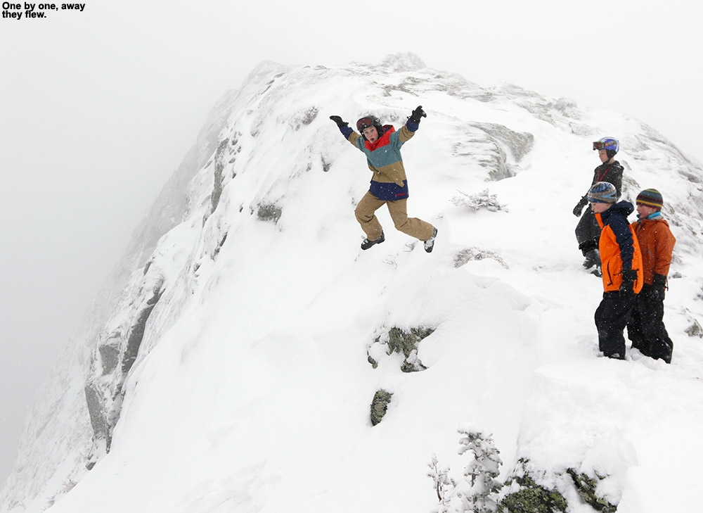
It’s that time of year again – the snowpack is deep, the weather is getting warmer, and it’s time to head into the alpine on Mt. Mansfield. After checking the forecast, the plan for our group in this afternoon’s BJAMS ski program at Stowe was to head up for some skiing in the alpine. E gave everyone in our group the heads up and told them to bring their ski packs, water, and snacks for a trip up toward The Chin. One idea I was tossing around was to bring our group all the way up to The Chin and ski Profanity Gully as we did last year, but I was also concerned that with some new students in the group that hadn’t hiked into the alpine before, something like Cliff Trail Gully would be a safer bet. When Ty started grumbling in the car about the length of the trip up to Profanity, that was enough to convince me that we should start with something a bit less involved. As we’d find out, that was probably a good call.
As we gathered the groups for ski program at the base of the Spruce Peak lifts, the composition of our group gradually took shape. We wound up with ten students, and fortunately, four adults as well. That was the largest group yet that we’d be bringing up above tree line, so the added help of multiple coaches was important. We’d had on and off snow showers around the mountain, but the weather was generally just cloudy as we took the Over Easy and the Gondola up to the Cliff House. For folks that had brought their packs to carry their skis, we took a few minutes and got everyone’s equipment set, then we headed up the boot pack. The snow in Cliff Trial Gully looked excellent, and it appeared as though only one hiker had been up the gully at all since the most recent resurfacing. Unfortunately whoever set the boot pack put in some pretty big steps, and that made for a real challenge for the kids – at times they said that had to make steps that were as high as their waist! I put in some intermediate steps to make things easier, but I could only put in so many new steps and still keep a good pace of climbing. We took a good break about halfway up where everyone was able to regroup, relax, and have snacks. Wiley had an entire box of Cheez-its, and I had to laugh. It was classic because I’d done the same sort of thing on one of my hikes to The Chin. For the final half of the hike, Dylan was a monster – he took the lead and blasted in a lot of kid-sized steps to make it easier for everyone. I took the lead again for the final five to ten minutes to the ridge line, and he’d inspired me to really put in a lot of extra steps, so hopefully it made it easier on everyone behind us.
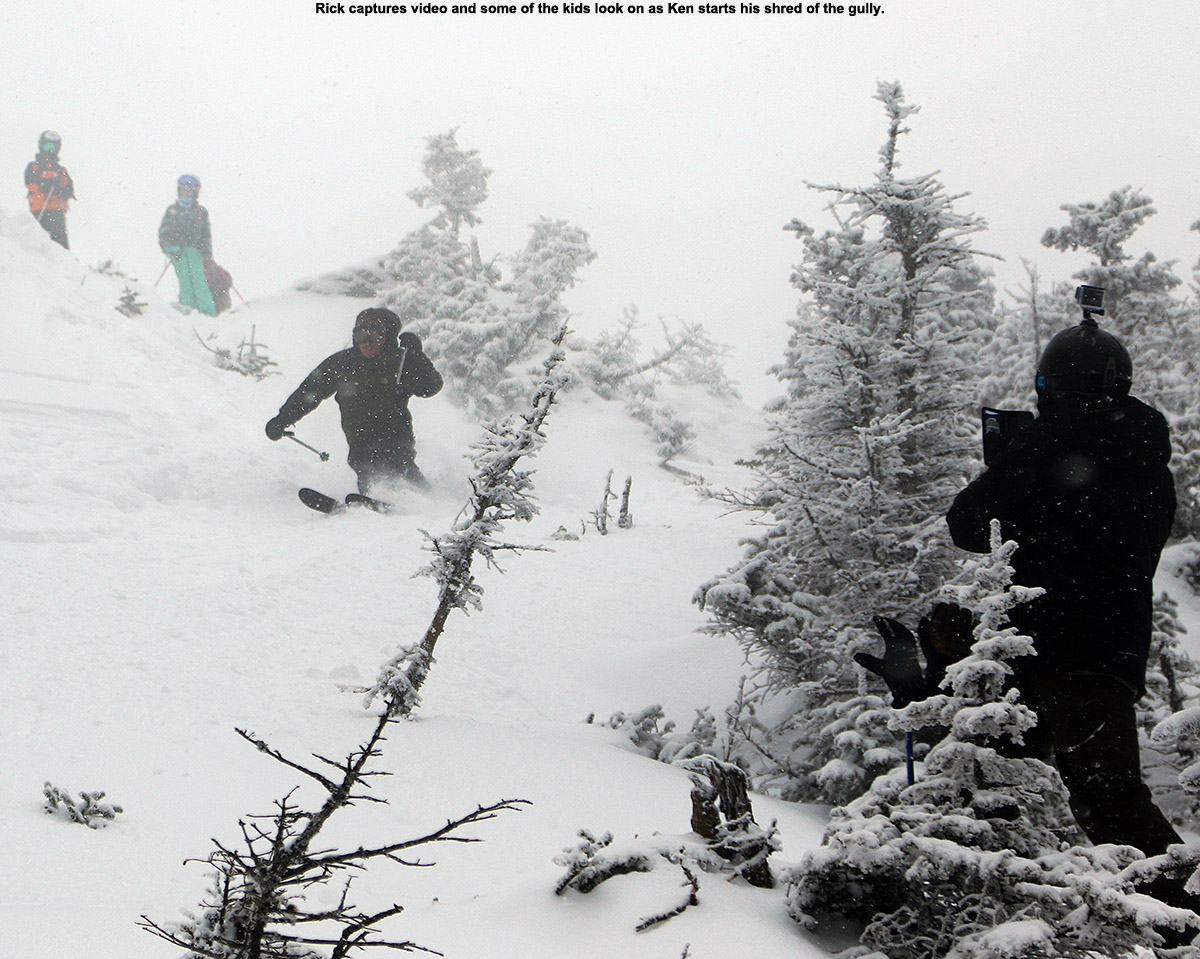
At the ridge line it was of course time for jumping into the powder on the leeward side of the ridge, and that went on for quite a while – essentially until they’d bombed all the powder they could find. Finally, it was time for the descent. I’d contemplated checking out a couple of other gullies nearby, but once I’d seen how good the snow was in the gully, there was no need. There were no tracks in it at all, so we had plenty of fresh snow. Just about everyone had begun their descent when we learned that one of Kenny’s skis wouldn’t go on. It turned out that he taken one of his mother’s boots by accident since it was very close in size to his, and it was too big to fit into is binding. Rick and I worked for a while on adjusting his binding, but there was just no getting that boot in there – even the longest setting was ¾ of an inch too small. Kenny had to work his way down the gully on one ski, and it was definitely good that we hadn’t gone all the way up to the Chin and skied Profanity. That would have been quite a chore. The powder in the gully was nice, but it was only a few inches deep up top where apparently the wind had hit the underlying snow. In the lower ¼ of the gully the powder was notably deeper, presumably because it was protected from the wind.
With the assistance of the helpful lift service staff, we set Kenny up with a trip down in the Gondola, and said we’d meet him over at Spruce as soon as we did the next run. That would give him plenty of time to work out the ski boot issue. The group hit the Tombo Waterfall and everyone did really well – the coverage is awesome in there. We got into a lot of the trees to the right of Gondolier and Joe really had some nice turns in there that kept him raving about that terrain the rest of the afternoon.
Back at Spruce we found Kenny, who had worked everything out, and we had time for a couple more runs before the end of the day. We hit Sunny Spruce a couple times and just enjoyed some good on piste turns. Joe was really interested in working on his bump skiing, so Dylan and I gave him some tips as we skied West Smuggler’s.
The weather was interesting today; snow really started to come in when we were up on the ridge line, and it gradually ramped up through the afternoon until it was absolutely dumping at the end of the day. You could hardly see 50 yards at times as the air was filled with massive flakes. I’m not sure how much the mountain was going to get, but if it was snowing that hard at the base, it must have been ridiculous up high. I suspect there will be some fun turns out there for folks tomorrow.
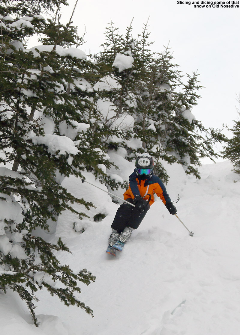
The boys headed up to get some turns on Old Nosedive today.
Today it was back to Stowe for BJAMS ski program, and a few key considerations came into play as I planned out our session. New snow this past week has been fairly minimal, but it’s also March 1st and we’ve got a healthy late-winter snowpack hovering around 80 inches at the Mt. Mansfield Stake. Temperatures were expected to be in the 20s F, so that would plenty comfortable for any extended backcountry or sidecountry runs with the kids. It seemed like a great day for a run on the Bruce Trail, and to add a little icing on the cake, I figured we could tack on some extra vertical and hit Old Nosedive to start the run.
The temperatures were simply perfect as we gathered everyone up at the usual group meeting place by the base of the Spruce Peak lifts. We took a run on the Gondola to warm up and get us over to the Fourrunner Quad, and without new snow that we had last weekend from Winter Storm Pandora, there were no lift queues like last Sunday. In fact, there were no lift queues at all. We warmed up on Cliff Trail, and found that it was a real zoo when we got to Nosedive. I’m not sure where all the people had come from, but if one hadn’t wanted to escape to a run on the Bruce Trail before that, it certainly would have made it more appealing. As is often the case, there was plenty of firm snow on Nosedive, and with the temperatures being so consistently wintry, it presumably had to be from snowmaking and skier traffic. We finished off the run with everyone working the bump lines on Lower National while thinking about their pole work, and the snow was much better down there.
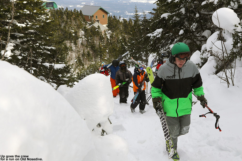
Heading up to start the run on Old Nosedive
From the top of the quad we headed up Old Nosedive, and hiked a couple hundred vertical before we got to some of the narrower shots and I decided that would be enough. I hiked on a bit father for some of the views from the Nose, and I could see lots of clouds from our next incoming storm while some of the first light flakes swirled around me. The descent was fun, and the snow was generally tracked but quite soft. There were even some pockets of powder still off to the sides.
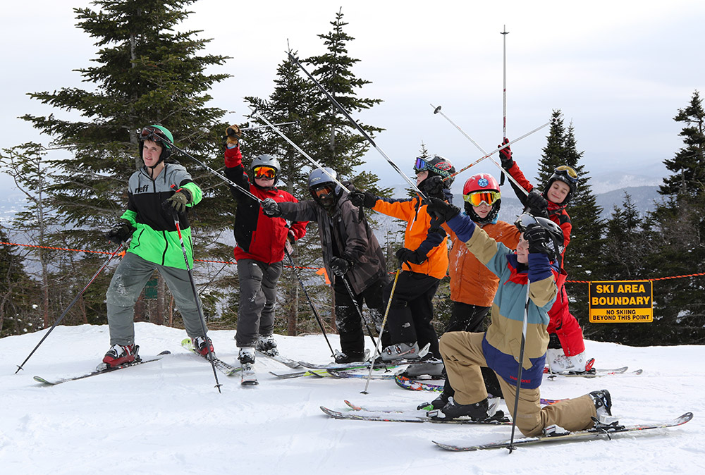
We headed down to the start of the Bruce Trail next, and after getting a couple of photos of the group, everyone dove in. The snow on the Bruce was well tracked and generally packed, but I’ve got to say that the overall conditions were right up there as some of the most consistently awesome I’ve had on there. Since much the Bruce faces south, it’s easy for some of those steep, south-facing shots to lose coverage, or at least start to thaw and refreeze a bit, but there was none of that. The coverage was simply wall to wall on every single pitch, and there just wasn’t any firm snow anywhere. I’ve certainly had softer snow on there closer to a storm, but I don’t know if I’ve seen coverage quite this perfect. There was plenty of powder everywhere off in the trees, and as usual it was untouched. Now that I’ve done the Bruce a few times I’m starting to learn that you can ski so many of the natural trees around there that you can turn it into quite a powder run if you want to. Wiley followed me through a great streambed when we were still up in the evergreen areas, and we got some beautiful first and second tracks through there. I got more untracked powder turns down in the hardwood areas than I think I’ve ever had this far from a storm, but really all you have to do is cut off the trail in those areas and the lines are all over the place. The snow was still wintry and quite fast when we were down on the Nordic trails, and we made good time aside from the typical hijinks from the boys. We had just enough time to stop in at the Notchbrook Convenience Store for snacks before we caught the bus back to the resort.
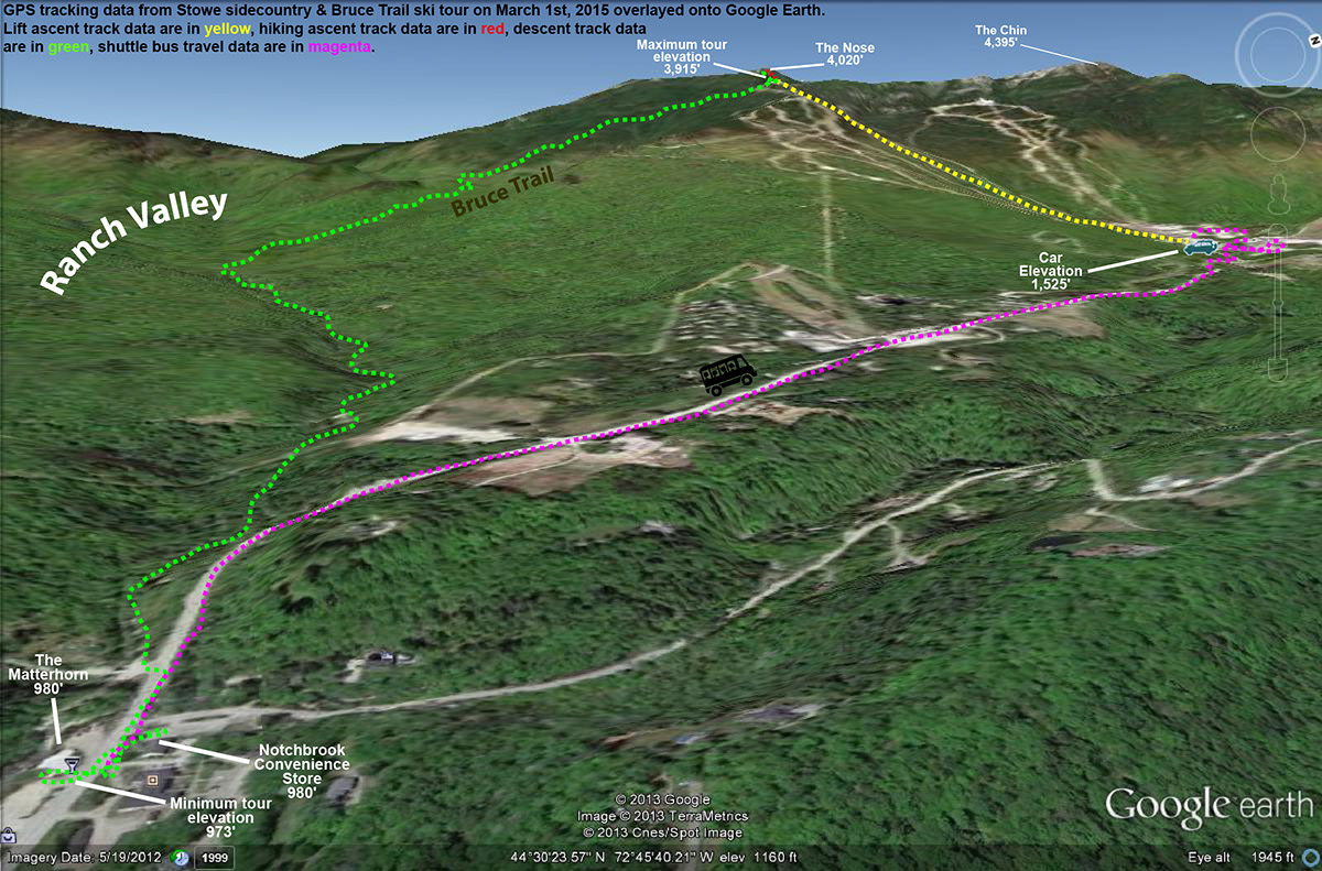
Google Earth map with GPS tracking data showing today’s skiing at Stowe and in the sidecountry on the Bruce Trail
The bus dropped us off right at the temporary sport for the village fire pit, so we caught the daily s’mores for the first time this season. We hung out for a while, then some folks called it a day while I went out with the boys for one more run off Sunny Spruce. We got into the trees west of the boundary like we’d done last week, and many of our tracks were still there, only buried a bit by the few inches of snow we’ve had since then. Open areas down low had even taken on a bit of a sun crust since they face south, but I guess that’s going to happen now that we’re into March.
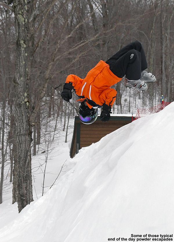
A day is hardly complete without some of those back flips into powder.
It looks like the pattern of storms is going to pick back up this week, with one going on already this evening and persisting for the next couple of days, and another one later in the week. Hopefully Mother Nature can cover up those tracks for us and we’ll have some fresh lines to check out next weekend.
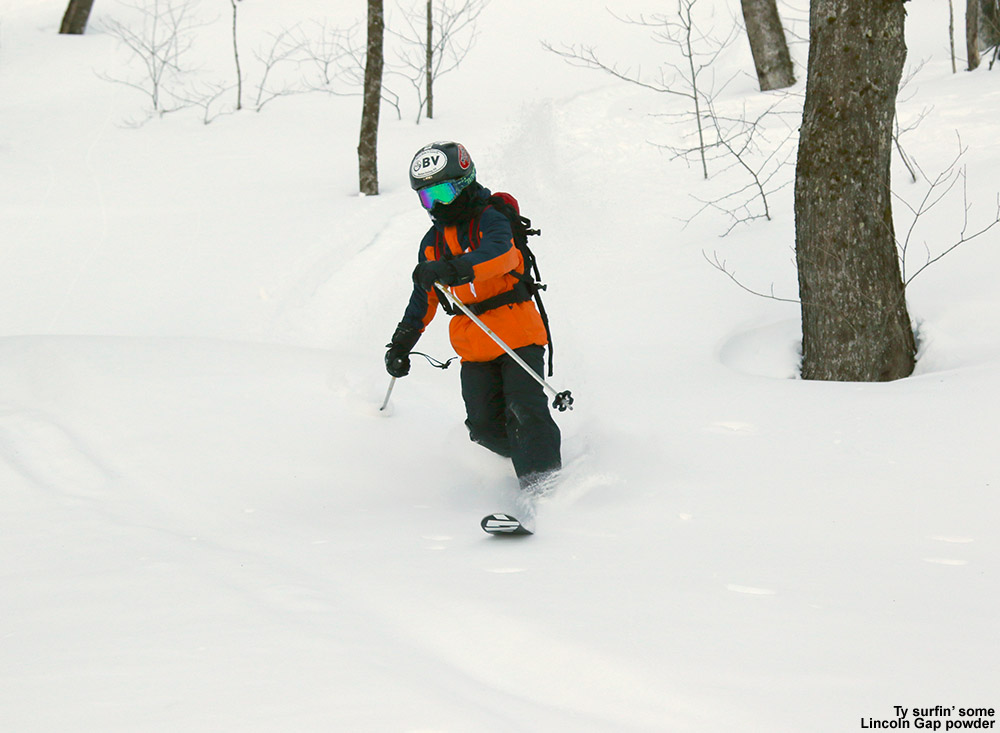
Ty heads out on today’s backcountry ski tour in the Lincoln Gap area
Unlike last weekend, where Winter Storm Pandora provided fresh snow on both Saturday and Sunday, new snow this weekend isn’t really expected until tomorrow afternoon. It also hasn’t really been a particularly snowy week, with no new snow in five to six days. Snow preservation has continued to be great though, and that brought about some interest in heading for some backcountry turns. I’d come across an article about some of the skiing in the Lincoln Gap area at the Nor’easter Backcountry Blog, and it sounded like there was a lot of potential. Guru Gered had put plenty of detail into the report, as well as a map, so it was a good aid for getting the general lay of the land and some ideas of where to go for quality turns. One great aspect about today that I haven’t had on a lot of backcountry trips this season was the temperature – it looked like it was going to be up into the 20s F, which was going to feel like a warm spring day.
“It’s obvious that there’s a massing amount of ski terrain there on the east side of Lincoln Gap…”
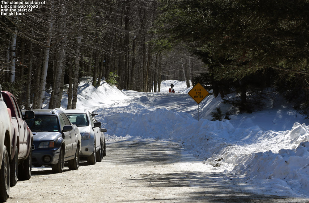
Starting the tour at the Lincoln Gap Road closure area
E was taking care of Dylan and an afternoon birthday party at a friend’s house, but Ty was free, so we let the day warm up with the help of that almost March sun, and headed south toward Warren in the afternoon. The sunshine was brilliant as we made our way through the Mad River Valley and up Lincoln Gap Road. After a few miles, the plowing ended, and we found about a half dozen cars parked where the road closure and snow began. From one of the cars, a group of sledders was heading out to ride on the snowy road, which I suspect is a popular activity just the way folks like to do it on Route 108 through Smuggler’s Notch.
“The powder was fantastic; certainly not super fresh, but there were no crusts of any kind and it was definitely super bottomless.”
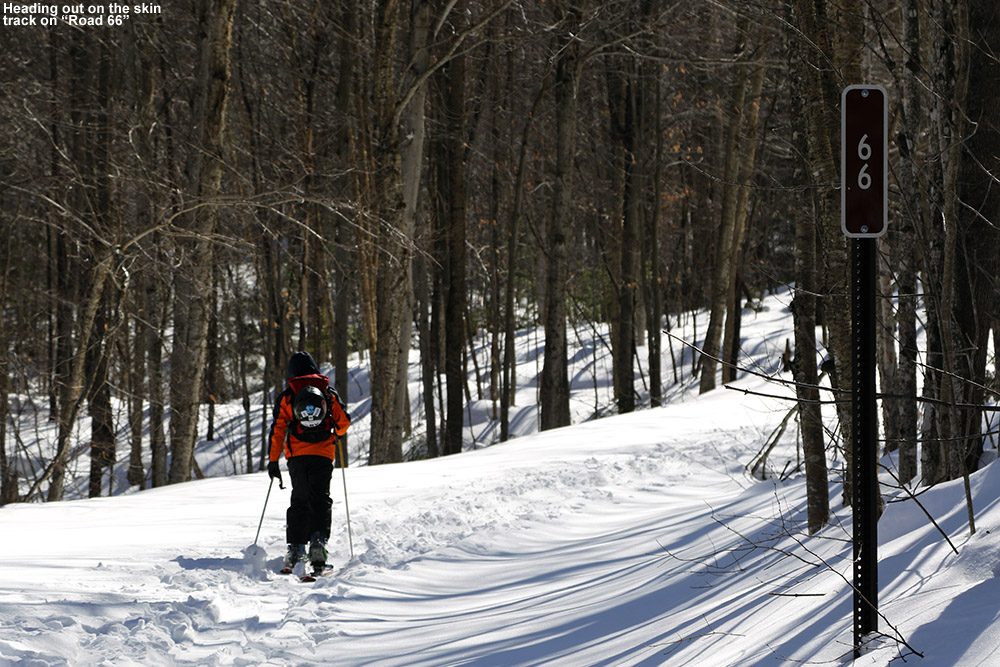
Ty and I started skinning right up the road, which was well packed through what seemed to be a combination of human and mechanized traffic. Off to the left of the road, the land sloped down toward Lincoln Brook, and off to the right it sloped upward the slope of Mount Abraham. You could immediately see great ski terrain right up in that direction to the northwest, but based on Guru Gered’s report, we were planning to tour off on the southern side of the road. After about five minutes or so, we found a service road in that direction marked with a brown “66”, and an obvious skin track on it; it was clear that this was a common route for skiers. The road headed gently upward in a southerly direction, still paralleling Lincoln Brook, and since the land still fell away in that direction, there was no obvious yet to the terrain beyond it. After roughly another ten minutes, the brook narrowed somewhat, the road bent in that direction, and we approached the foot of the mountainsides now visible to our south.
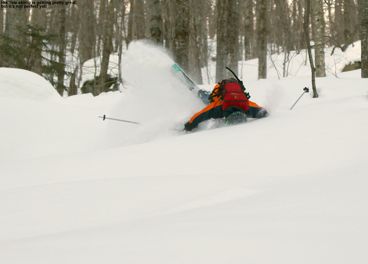
“You also know that the terrain is pretty steep when you head over the handlebars for a crash into the powder, and wind up back on your feet after a full flip – Ty demonstrated that one for us.”
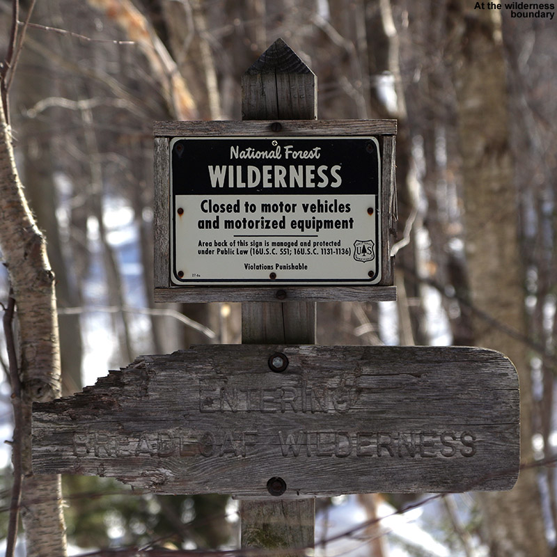
We met a couple there, who were out backcountry skiing with their young daughter – she was at the age where she was still riding in a pack (I can remember those days). We chatted for a bit, and the dad gave me an overview of the area. Above us to the west, we could see some fairly gentle slopes that formed the bottom of the drainage and headed up along the continuation of the brook. He said that a few skiers had been in there in the morning. We were informed that the main skin track wrapped back around the brook, heading east for a bit below the slopes above, and then turned more southward. We’d hit a sign marking the wilderness boundary, and from there you could continue south up that drainage where there were some options of trimmed lines as well as the streambed itself. From that point there was also the option to head back to the west and work your way up to the slopes right above us.
We thanked him and made our way along the main skin track that wrapped around the brook. The skin track was on a nice gradual grade that seemed to be an old logging road. Even after just a few minutes up that route, we could start to see some nice open lines dropping below us toward the brook. We hit the wilderness sign after about a mile of total distance, and based on time, we opted to head back west up above the slopes that would lead us back down to where met the family earlier. From that point the skin track went up and up and up (so it seemed) generally heading westward but with lots of switchbacks. We actually saw the family again, because they were heading up into that area as well and had taken a more direct skin track that eventually merged with the one we’d used. It seemed like it took forever, but we eventually hit the ridgeline above us as the terrain flattened out. One option of the skin track actually continued upward as the ridgeline continued to rise to the east, and that’s actually the way that the family was headed. I’m not sure exactly how much higher it went, since Ty and I took another track that headed along the ridgeline in a more westerly direction. We followed that for a few minutes until we came to where the previous skiers had started their descent. We could tell that this was generally going to get us back to the drainage where we’d started, and it looked like a decent option.
Ty making great use of that deep powder out there to cushion a spectacular fall with a full flip
We did a quick changeover to descent mode and were on our way down. There were the few tracks of other skiers in the general area, but there were plenty of fairly open trees all around, and you could spread out with plenty of space if you wanted to get away from signs of other tracks. The powder was fantastic; certainly not super fresh, but there were no crusts of any kind and it was definitely super bottomless. The terrain was steep, with plenty of shots of 25 or even 30 degrees, and you know the surface snow is seriously deep above the base when you can crank turns on those pitches and not touch a thing. There were good lines all over the place, and some of the most fun was riding the main streambed – everything is so buried in there under deep snow that there’s really nothing to worry about when the snowpack is like this. Ty was on fire with the Telemark turns, and I think he might have even been more consistent with them than me. He’s been doing cross country skiing in a program at school, and I think that’s gotten him even more attuned to his free heel work. If we had our druthers, we actually would have chosen a run with a shallower pitch than what we hit, since we’d been planning of something of a more intermediate pitch that really made for easy Telemark turns. But by the time we were done we’d realized that it didn’t matter; the powder was so consistent the tree spacing so good that even the steeper pitches had been working well.
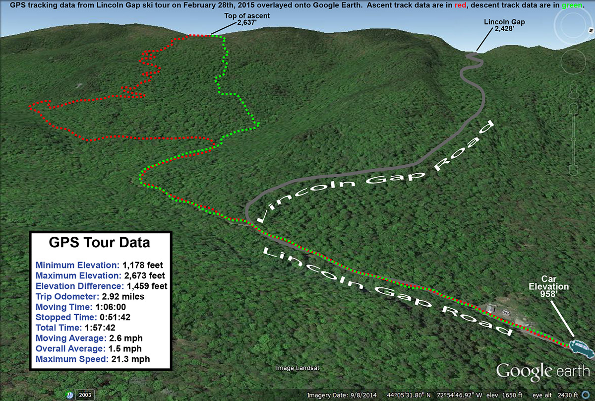
A Google Earth map with GPS tracking data from today’s backcountry ski tour in the Lincoln Gap area
We eventually hit the bottom of the drainage, and headed down it to the right. We hadn’t known just how close we were to the service road, but were hit it in just a minute or two. From there it was a few minutes of gliding back to the car on the skin track. It’s obvious that there’s a massing amount of ski terrain there on the east side of Lincoln Gap, and much in line with what Guru Gered said in his report, there is a lot of prime hardwood skiing terrain out there. If you don’t have a couple feet of powder, I’m sure some of those steeper lines are tougher to ski, but there’s plenty of mellower terrain out there as well. I have no idea how long it would take to explore even half of the potential terrain that’s out there, but I’m sure it will be fun.
Making some turns out in the Bolton Valley backcountry today
The forecast for today had always been a cold one; earlier in the week it looked like high temperatures were going to be below zero F, even in the valleys. There’s no doubt about it, when the high temperatures don’t reach zero, that’s cold, even by Northern New England standards. When coupled with the vigorous winds from departing Winter Storm Neptune, wind chill values were going to be pushing into the -50 F range in the evening, and that’s just brutal. Fortunately, as the forecast was refined, the anticipated temperatures came up a bit, and the actual temperatures today turned out to reach around 10 F down at the house around midday before they really began to fall in the afternoon. With the forecast, my ski plans for today had always been to head into the protection of the backcountry instead of riding the lifts, and with the combination of temperatures and wind, it looked like there were going to be some “cold holds” for the lifts at the resorts anyway.
“It was easy to see that one could use the trail just like a road with switchbacks on a mountain pass and lap some great lines in that area.”
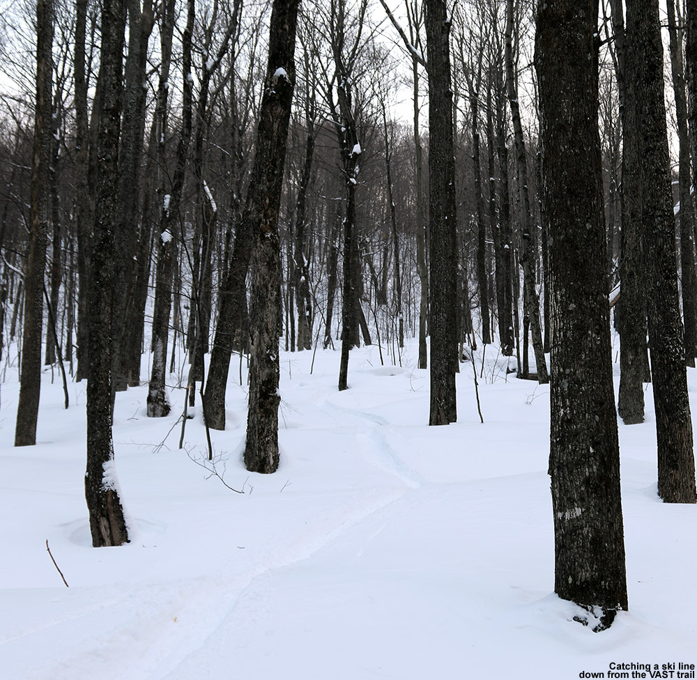
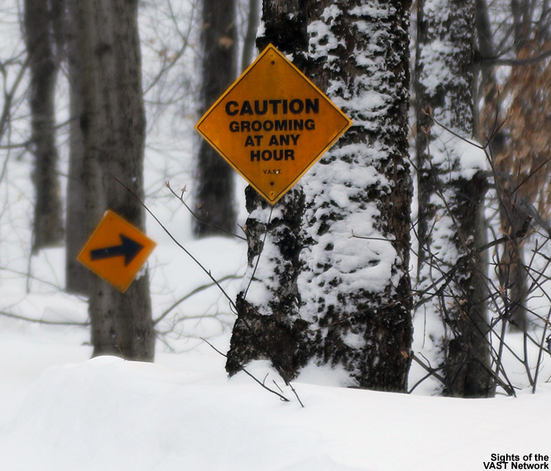
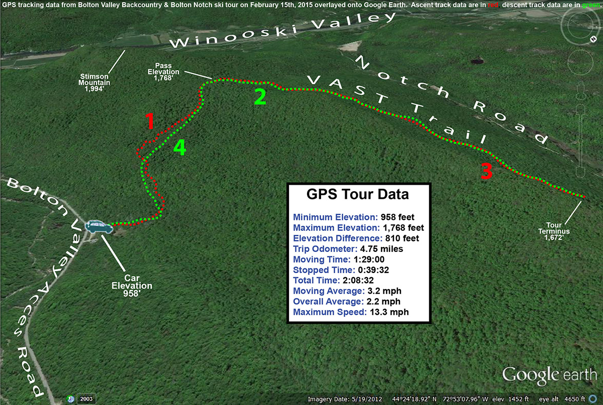
During my ski tour a couple of weeks ago at the northern end of Bolton Notch, I spoke with a woman who lives in the area, and she said to check out some of the ski terrain above the VAST trail farther south. When I thought about a good access point to the area, the VAST parking area along the Bolton Valley Access Road came to mind. The VAST trail from that point actually goes up and over the pass just north of Stimson Mountain, then drops down and contours along the east wall of the Bolton Notch area. The last time I’d done a ski tour originating from that VAST parking area, I’d quickly left the VAST trail and headed straight up to the ridge, so this would give me the chance to tour the terrain more proximal to the trail itself in Bolton Valley, and then connect right onto the VAST trail on the other side of the ridge to explore the ski options there. I’d also had this ski tour on the list for today because I knew that with the very low temperatures, I’d want something fairly quick and close to home, and this fit the bill.
Checking out one of the lines below the VAST trail as it switchbacks it way up toward the pass
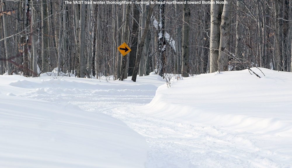
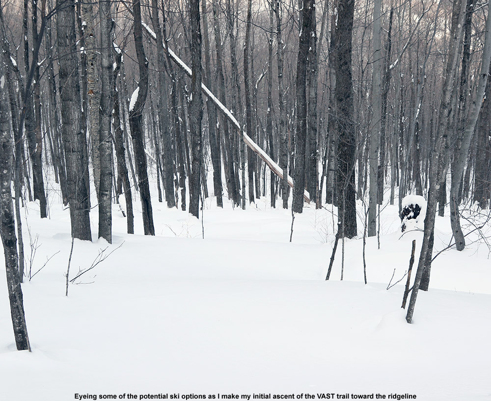
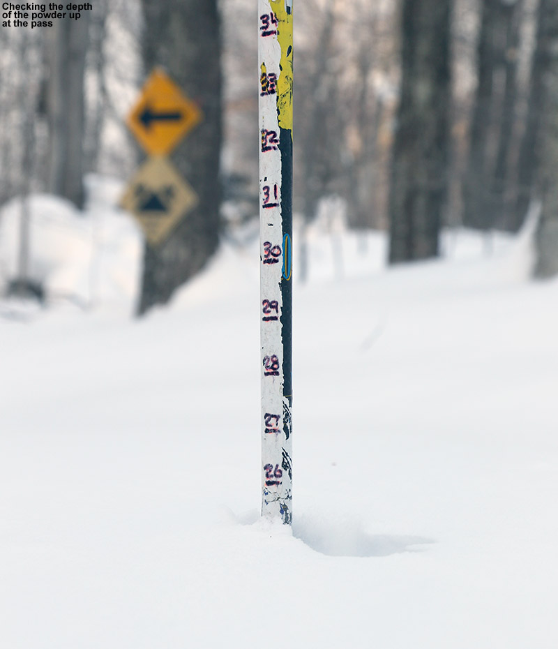
Temperatures had already dropped a few degrees at the house by the time I got on my way up to the Bolton Valley area, and the thermometer was right around the 0 F mark when I pulled into the VAST parking lot. The wind there in the somewhat open surroundings exacerbated the cold temperature, so I got my gear on quickly and headed right onto the VAST trail and into the protection of the trees. After a few minutes I hit the first big turn southward, and since this is where I’d broken off the VAST trail the last time I was there, it was new to me from that point on. I actually wish I’d headed that way sooner than this tour, because there are some nice ski options all around there on the slopes surrounding the VAST trail. It was easy to see that one could use the trail just like a road with switchbacks on a mountain pass and lap some great lines in that area. I noted a number of great areas to drop in as I wound my way up the ascent, and I eventually hit the pass over the ridge line at an elevation of ~1,750′.
Sights on the VAST trail heading from Bolton Valley toward Bolton Notch
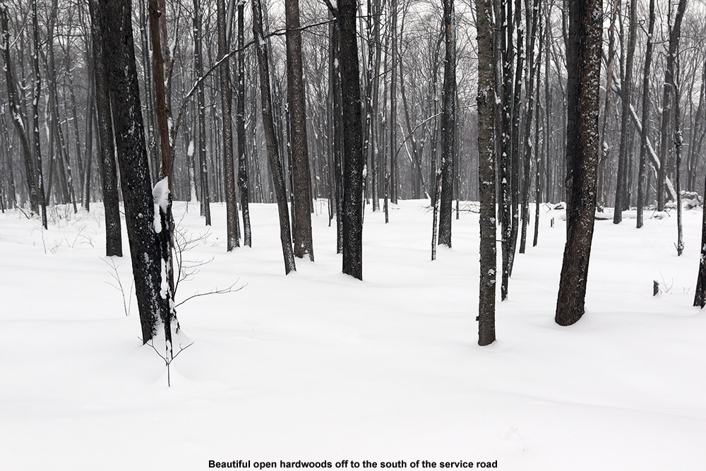
As I broke out of the shelter of the leeward side of the ridgeline, the winds picked right up, probably hitting 20-25 MPH at times. Fortunately that was short lived because I was quickly back down the other side into the shelter of trees. At the pass there’s an obvious height of land just to the south in the direction of Stimson Mountain, and to the north the terrain rises more gradually as the ridgeline gains elevation. I continued on the VAST trail, heading northward, just checking out the potential ski terrain in the surrounding trees and planning to go as far as time would allow. All told I probably covered about a mile or so of distance as I headed northward on that side of the ridgeline. I generally focused on the potential ski terrain above the trail, since that would make for the most convenient setup in terms of finishing at the trail, but I did look at the terrain below as well. The makeup of the forest varied quite a bit along the route, and I assume that depended on the tree composition, and probably more importantly, how old the trees were with respect to the last time the land was logged. There were some nice open areas of trees in the first few minutes north of the pass, although those lines down to the VAST trail itself were relatively short since the trail was just leaving the ridgeline. Beyond that, the next five to ten minutes along the route revealed denser foliage that didn’t seem to offer too many great lines. After that point though, there was another extended section where tree spacing and underbrush looked quite good, and I did see a couple of ski tracks here and there from people that had skied some of the lines. Those lines were definitely longer that those up near the pass, since the VAST trial was a bit lower and the ridgeline had risen. The trees with decent potential went on for a while, but gradually gave way again to denser undergrowth at the stage where I finally turned around to make my way back up to the pass. Throughout my out and back on the west side of the ridge, I hadn’t taken any breaks aside from snapping an occasional photo or GPS tagging a promising line, and the constant movement was definitely a benefit. I was shooting pictures with the 7D2, and definitely appreciating the fact that it’s got the integrated GPS and automatically tags the images locations for future reference. Simply snapping an image and knowing it’s got the exact coordinate embedded is much faster than dealing with the full GPS unit all the time, and that’s appreciated on days like these when you don’t want to stop moving for long. My left toes were just on the verge of getting cold when I was on the generally easier, more downhill travel northward, so it was obvious that I needed to keep the blood pumping.
I retraced my way back southward on the VAST trail, and regaining the pass, I continued just a bit down on the leeward side to get out of the wind and then switched over for the final descent back down to the car. I checked the depth of the surface snow and it was over two feet up there, so that bode well for the descent. The air definitely felt like it was getting colder as darkness approached and that northwest wind continued to transport more arctic air into the region, so I stuck with the theme of moving quickly. I’d kept in mind some of the best looking ski lines when I’d made my initial ascent up that east side of the ridge, so I went with turns along the VAST trail itself at first, before finally diving into some open hardwoods off to the skier’s left. The powder was great, with my only complaint being that the skiing was slower than it could have been simply due to the very cold temperatures. I caught back up to the VAST trail at the next switchback, and the mixed up turns on and off the trail from that point downward. I actually saw a group of skiers coming down through one of the very open areas above the final descent to the parking area. It was interesting that I saw them out there, because in all the miles I covered, I didn’t see a single snowmachine. I’m not sure if folks were staying in because of the cold weather, but they definitely weren’t out there on their sleds on that part of the VAST network this afternoon. I had seen one snowmobile trailer in the parking lot when I’d arrived, but it was gone by the time I got back to the car.
The GPS tracking data from today’s backcountry ski tour in the Bolton Valley and Bolton Notch areas plotted in Google Earth
The wind was picking up and it felt especially cold back at the car; I’m sure the wind chill was well below zero. I started the engine warming while I put away my gear, and got rolling as soon as possible. As much as this cold air has been awesome for powder and general snow preservation, one of these days we’ll be back into some reasonably warm air (like yesterday), and that’s going to be nice. One of these days I’d like to explore terrain in the Bolton Notch area farther to the north near the Long Trail, so that’s on the list for a future trip, but there were definitely some nice ski lines at this southern end as well, and the access is very quick thanks to their proximity to the parking area.
“Even down at that elevation, the snowpack was running at roughly 20″ on the level, and starting from the fluffy powder on top, there were gradually denser layers as you went down.”
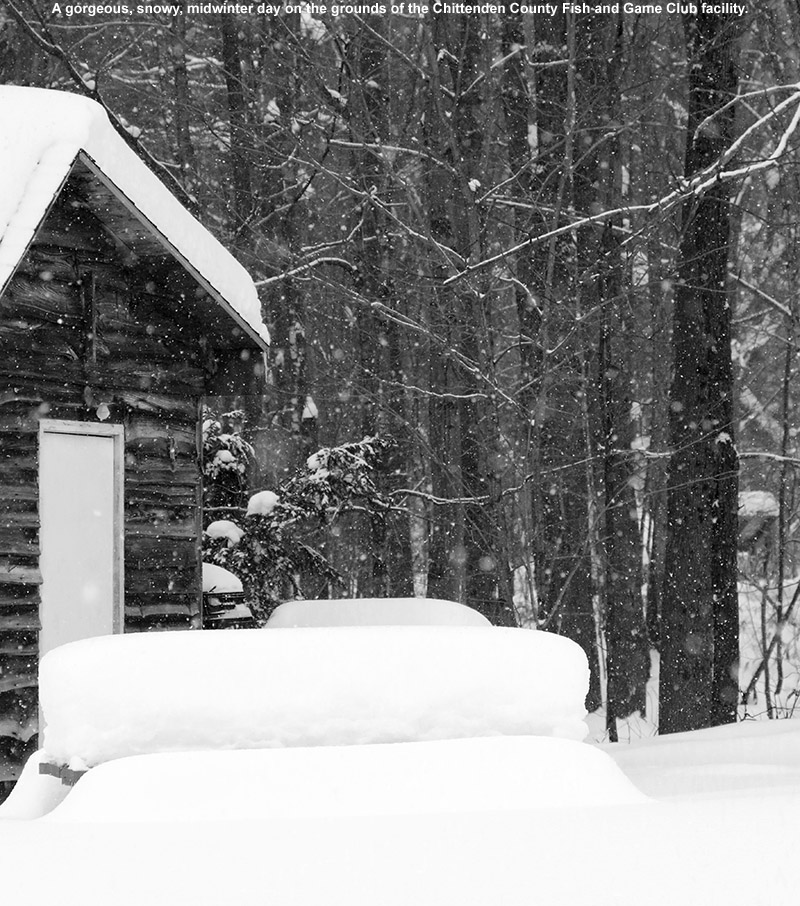
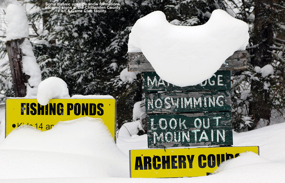
We’re currently under the influence of Winter Storm Neptune, and although the snow has generally been light here in Northern Vermont, it’s still putting down a fresh coat of powder on the snowpack and generally keeping things quite wintry. Light snow from the morning had tapered down a bit as I headed off in the afternoon toward Richmond, and I cruised westward with the car thermometer showing temperatures generally in the mid to upper teens F. Although I wasn’t familiar with the location of the Chittenden County Fish & Game Club parking area, I’d plugged a nearby address into the car’s GPS, and once I got close, I found the entry to the game club well signed. The road was nicely maintained, and in the parking area I found a couple of other cars there that belonged to people who were using the shooting range. Beyond that initial parking area, the road was plowed for another couple hundred feet, but the plowing abruptly stopped so the parking near the shooting range ended up being the best option for parking the car to start the tour.
The grounds of the Chittenden County Fish & Game Club held plenty of deep snow.
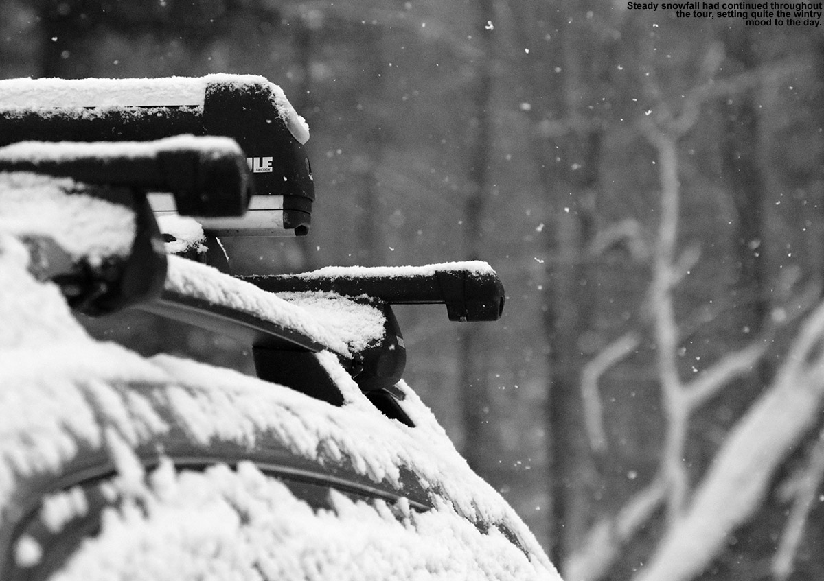
As I geared up, the snowfall began to intensify and the flakes became larger, so the storm was definitely on an uptick. Occasionally I’d hear the sound of gunfire coming from the range, and it was pretty loud since I was only 50 feet away or so. I wasn’t exactly sure where to go to start my tour, but I certainly wasn’t heading southward anywhere near the shooting range, and with Robbins Mountain looming off to my east, the partially plowed road that headed in that direction seemed like the logical choice. I’d initially had some concerns about the snowpack in the lower elevations of Robbins Mountain, since the parking area is at an elevation of only 750′, but those concerns were allayed as soon as I started skinning along and took a few depth measurements. Even down at that elevation, the snowpack was running at roughly 20″ on the level, and starting from the fluffy powder on top, there were gradually denser layers as you went down. So indeed the snowpack there at the base is just about the same as what we’ve got at our house at 500′ in the Winooski Valley, and since the snow depth was only going to increase with elevation, I knew there wouldn’t be any problems with snow coverage.
Signs for the fish and game club buried and covered with snow
“…when I later saw how deep the snow was and how steep this vehicle could ascend despite such deep snow, it had to be something with tracks on it.”
As I followed the plowed road I found myself skinning through some of the fish and game club’s facilities, noting the deep stacks of snow that sat atop everything, and I worked my way toward what seemed to be a gate at the far end of the complex. With the temperature near 20 F, it was feeling downright balmy compared to some of the ski tours I’ve done in the past few weeks, so it was really a gorgeous midwinter day. At the gate there was an opening off to the side for foot traffic, and I saw what appeared to be one track from someone on snowshoes. Beyond the gate I was on what appeared to be a service road, and it had seen some interesting traffic. The tracks I saw appeared to come from a wide vehicle, and at that point it could have been a jeep, but when I later saw how deep the snow was and how steep this vehicle could ascend despite such deep snow, it had to be something with tracks on it. Whatever it was, it gave me a semi-packed track to use for skinning, and that helped a lot because it would have been quite a slog through that deep powder without it.
“…the spacing of the trees was so good, and the snow surface so consistently smooth and unadulterated by anything below, that you could have enough confidence to make whatever turns you wanted.”
It was pleasant skinning along the service road with light snow falling and no wind, and after about a half mile the service road forked. The right fork seemed to continue contouring along and slightly up to the south, and it actually had a set of ski tracks on it. The other fork interested me much more though, since it headed east toward the higher elevations, so I opted for that route. Following that fork, the road meandered generally to the east, with switchbacks at times to keep the pitch moderate. I was actually amazed at some of the pitches that the vehicle making those tracks had climbed, so it must really be built for dealing with deep snow. At around 1,700′ the vehicle tracks finally stopped, and a single track continued on. The track was so old and buried that it was hard to tell what it was, but it certainly could have been an old skin track.
“The trees were so open with respect to underbrush that I wondered if the area was part of the successional cuts that are made in the area as part of the wildlife management.”
Not long after the single track began, the road took a sharp left and headed north. A quick look at the overall terrain and vegetation in the area made it obvious that that wasn’t the way for me to go. The underbrush was denser in that direction, and the terrain looked like it would head into more ledges. My thoughts were drawn much more to the south, since on the ascent I’d seen what appeared to be some excellent open terrain a few hundred feet off in that direction. Coincidentally, or more likely not, the single track that I was on seemed to head in just that direction. It wasn’t obvious that it was a skin track, and it actually seemed more like a game track, but it went exactly where I wanted to go, so I followed it. Within a few moments I was into the open trees that I’d seen, and boy did that look like some good ski terrain. The trees were so open with respect to underbrush that I wondered if the area was part of the successional cuts that are made in the area as part of the wildlife management. The terrain wasn’t overly steep, but it looked like it would offer up some really nice turns, especially in conjunction with the fantastic snow that was underfoot. I continued to follow the track up through the open trees, and with the path the track took, it really could have been made by a skier. It seemed to skirt right along the top of some of the more open sections of woods, seeming to pick the perfect line to get to the apex of that terrain. A few hundred feet above me I could see where the terrain began to steepen dramatically, and based on my elevation I knew that was the final headwall leading up to the ridge extending south from Robbins Mountain. I expected that the trees would get to tight and or brushy once I hit the headwall, because that’s sometimes what happens as the composition of the forest changes, so I was getting set to find a good spot for my transition as soon as I reached the top of the open trees below.
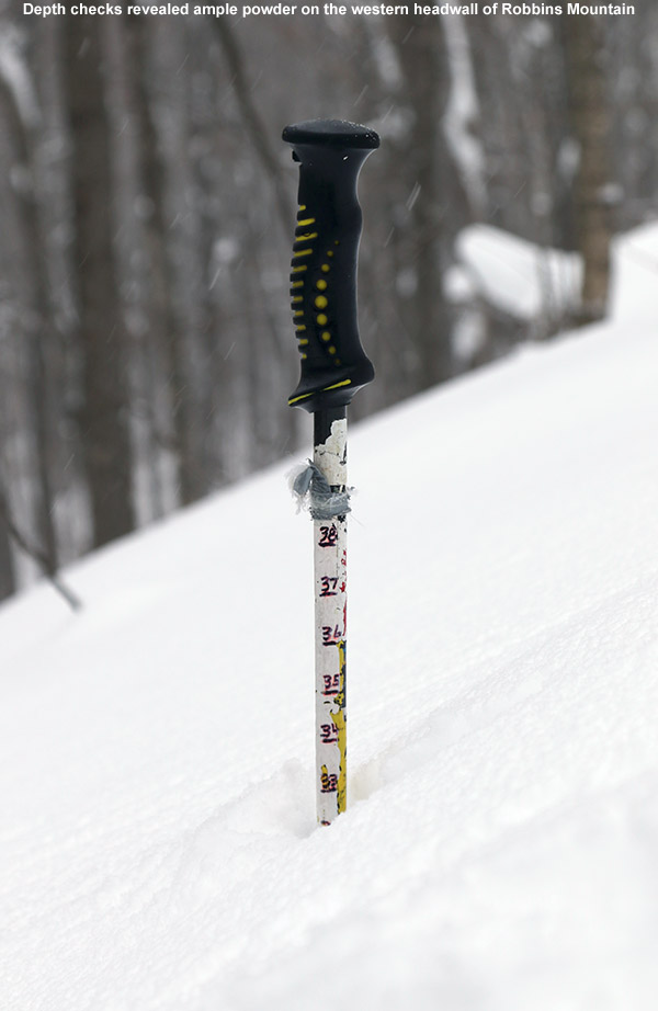
Checks revealed close to three feet of powder bellow the ridgeline on the western headwall of Robbins Mountain.
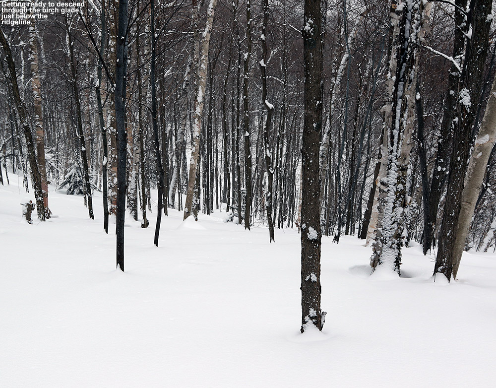
When I finally approached the headwall though, I had to reconsider my initial plans of not skiing it; what I saw above me was just too good to pass up. The trees continued to be quite open for another hundred vertical feet before ledges took over, so I had to head up a bit more. That terrain would make for a great start to the ski run. The ascent track I’d been following didn’t go that way, so I had to break trail, and it was somewhat slow going with the pitch of that slope and the depth of the snow. I clicked up my rarely used, tall heel lifts, and kept at it. The pitch was easily 25 to 30 degrees, and though I made switchbacks it was a slog through that powder. I did some depth checks and the surface snow was pushing three feet of depth, so even with the floatation of 115 mm fat skis I was down a good distance in that snow. I thought I’d catch another hundred feet of vertical or so out of that ascent, and be just below the steep and ledge terrain of the headwall, but as I continued to ascent, a beautiful gully full of nicely spaced birches appeared to the southeast. It actually ascended all the way up to the ridgeline, slicing to the northeast through the ledges, and it was almost as if Mother Nature had made a passageway to permit skiing down from the ridgeline. I had to keep going because there was no way I was going to miss the chance to tag the ridgeline and ski that beautiful gully. So after a bit, or perhaps more, of additional work, I reached the ridgeline.
“Those turns through the birch glade and then the lower reaches of the headwall were deep and smooth, and you almost couldn’t ask for better snow.”
When I got to the ridgeline I had some flashbacks of my most recent trip to Robbins Mountain with James. It was nice up there though, with very little wind and good temperatures. I had some food, and switched over for the descent. My depth checks continued to reveal snow depths approaching three feet up there, so even on the steepest pitches there were no concerns about snow coverage. Those turns through the birch glade and then the lower reaches of the headwall were deep and smooth, and you almost couldn’t ask for better snow. The powder had an excellent density gradient, and you could cut into it as hard as you wanted. The only things to watch out for were obvious big logs, which you could easily see. I mixed it up with both Telemark and alpine turns, but the spacing of the trees was so good, and the snow surface so consistently smooth and unadulterated by anything below, that you could have enough confidence to make whatever turns you wanted. Below the headwall I got into the very open hardwoods, and the skiing was mellower, but oh so good. The coverage and general consistency of the snowpack, and the lack of (or perhaps buried nature of) underbrush means that you can just let the skis run and run and you’ll just keep finding that great ski terrain appears.
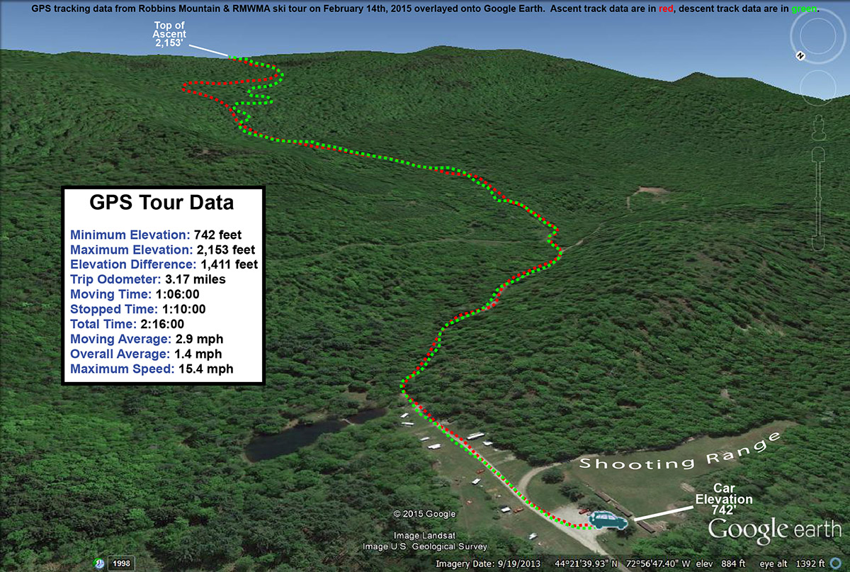
A Google Earth map showing GPS tracking data for today’s backcountry ski tour on Robbin’s Mountain
At roughly the 1,300′ elevation I finally merged my way back onto the service road and skin track, and from there on down I stuck close to the track. I still made occasional turns in the powder, but being near the track was really helpful as the pitch of the terrain lessened. Following the general area of the service road ensured an efficient runout and exit from the tour, because the powder out there right now is just too deep to keep up speed if you don’t have that necessary pitch. I was able to make a quick descent right back to the parking area thanks to the service road and my skin track. I’d say that a good way to cycle that terrain would be to head down to that 1,300′ level and catch the skin track back up, and then simply hit the runout at the end of the ski session. Surface snow depths of 6-12″ of powder would be fine for everything but the headwall area, and you could probably ski some additional mellow pitches if the snow was in that state. It’s really hard to complain about the current snowpack though, it so deep and soft that it’s hard to say enough about how well it skis. With good access and some great open terrain, I’d say that RMWMA zone is a nice option when the snowpack on the lower elevations of the west slopes is sufficient. When I got home I told E that it would be a good spot for her and the boys, so hopefully I’ll get them out there one of these days so that they can see what it’s like.


