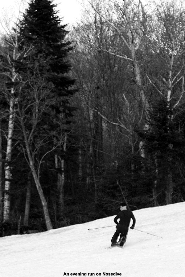
Out for some Memorial Day Weekend turns on Mt. Mansfield
This Memorial Day Weekend certainly hasn’t been like last year, with its two feet of new snow, but even from Waterbury one can see that Mt. Mansfield still has some of this season’s snow left on it, and with today’s great weather, it was hard to pass up the chance for some skiing. We’d actually been keeping our eyes on the weather over at Mt. Washington for a potential trip to ski the summit snowfields this weekend, but the forecast for nice weather didn’t end up being quite solid enough for us to make the commitment. Of course, being around at home meant that the opportunity was there for some local turns. I thought last week’s ski trip with E and the boys might be our last turns on Mansfield for the season, but that wasn’t the case… at least for me. Even last week, the skiing payoff relative to the hike was getting pretty marginal for the rest of the family, so although I did a perfunctory check to see if any of them wanted to go, I would have been surprised if any of them said yes. This time of year, it’s typically a good idea to go into a ski tour with the intention of enjoying the hike itself, because it’s often a big part of the outing relative to the skiing. If either of the boys had wanted to go on today’s tour, they would have had their work cut out for them, because I knew that it would require at least 1,000’ vertical of hiking before hitting decent snow. They barely have the patience for earning turns when the skiing is top to bottom, so all that hiking before getting to the snow wouldn’t be well received.
“You can get a nice 300’ or so of vertical out of it, and if you wanted something to lap with the best turns, that would be the place.”
After some midday yard work with the boys, I finally headed off to Stowe in the mid afternoon. The valley temperatures were generally in the mid 70s F, and the skies were mostly clear aside from a few clouds here and there, and a surprising number of leftover contrails. From Waterbury Center I could already see patches of snow left on Mt. Mansfield near the Cliff House, so I knew that the Nosedive area would have snow. I parked in the Midway Lot at 1,600’ where I saw a few other cars, but very little activity aside from the occasional group of hikers. Temperatures were still warm, so my setup for the ascent was a short sleeve polypro T-shirt, shorts, and socks/Tele boots, and I packed my ski pants, a long sleeve polypro shirt, and my gloves in my pack for later use. I’ve been very impressed with just how flexible my Garmont Garas have been these past few warm, spring-style outings. Throw them in walk mode and add temperatures like today, and it’s like walking in a pair of stiff hiking boots. They’ve got Vibram soles, so the grip is nice on most surfaces. They certainly don’t match up to the a pair of good hiking boots when trying to hop from boulder to boulder working one’s way across alpine areas of Mt. Washington, but for traipsing around on the generally grassy or slightly rocky slopes below tree line, you can hardly tell that they’re there. For trips like today’s, being able to hike up, skin, ski, and hike down comfortably in one pair of boots makes everything so much easier, both in terms of weight and ascent/descent transition times. Of course I probably make up for some of the weight savings carrying camera gear, but the light weight of Telemark skis and bindings also cuts down on the pounds.
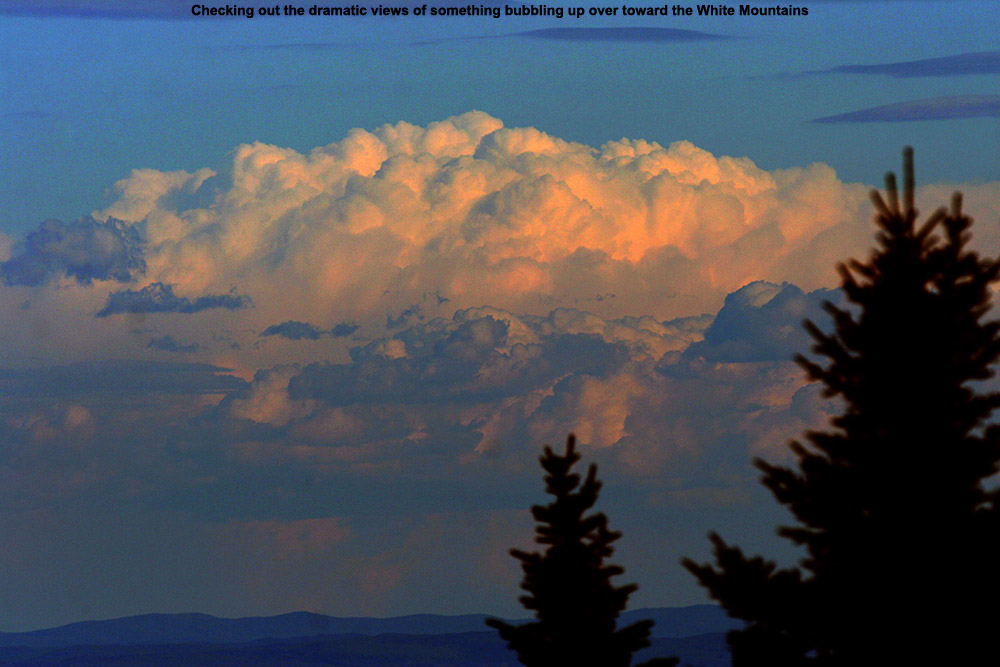
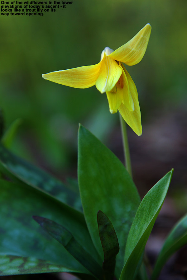
Enjoying the mountain views of storm clouds off to the eastSigns of spring during the hike
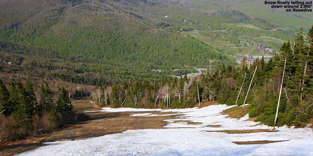
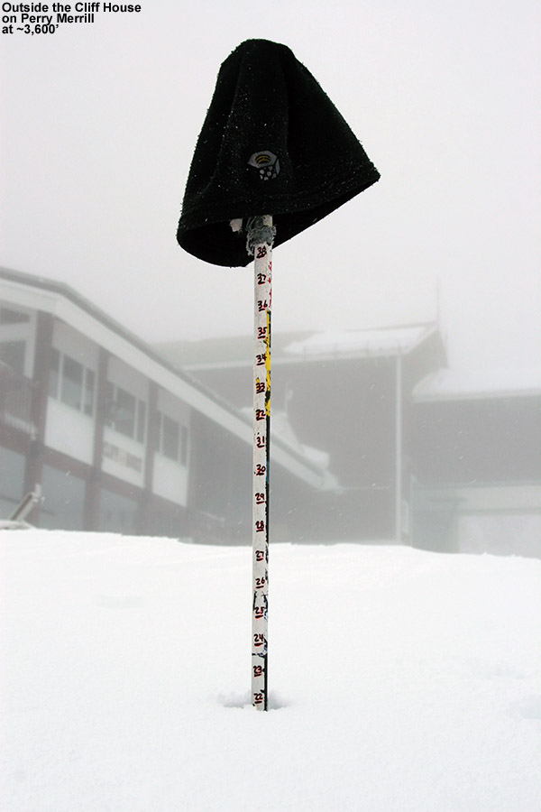
As far as the snow goes, there were a couple of piles here and there even down near the base, but nothing of real consequence. I didn’t start to see more consistent patches on Nosedive until I got up around the 2,100’ mark at the junction with National. What I did get to see in the lower elevations was the appearance of wildflowers, including what looked like some trout lilies on their way toward opening up. Even though we had some rain yesterday, Nosedive was really pretty dry aside from areas in close proximity to snow patches or the occasional water bar with meltwater, so that made the hiking especially easy. The mid afternoon sun was still quite strong during my ascent, so I hiked in the shade when possible. As for the insects, all I saw was the occasional mosquito, so that made for a pleasurable ascent on that front. The presence of patchy snow off to climber’s left was all that I saw until I got up near 2,600’, and just below the intersection of Cliff Trail I saw the first area of coverage across the whole width of the trail. That was only an isolated section, and it was back to grass for a while above there, but once I got up to ~2,900’ I got into the nearly continuous snow, and there was even some snow remaining in the trees on both sides of the trail. The snow depth at the Mt. Mansfield Stake just up above that location at ~3,700’ was down to only two inches as of today’s report, although it was certainly deeper in those areas of trees I saw. I continued my ascent all the way up to roughly 3,600’ because the snow just kept going. There were a couple more breaks, but they were small enough that it kept me interested in reaching the top pile near the junction with the Toll Road (which is definitely open – I saw a car on its way down while I was up there).
The bottom section of today’s snow on Nosedive
At the top I could definitely feel the ascent, so I downed a GU and cracked open and Odwalla smoothie that I’d been saving for the top. Between the amounts of sugar in those, recovery and rejuvenation were quick. I moseyed around up there for a bit and got a few pictures, and then geared up for the descent. If you’ve ever wondered about why you’ve got full side zippers on your ski pants, well here’s one of those perfect situations that call for them. You don’t spend time taking off you ski boots to get your pants on, you open up those zippers, strap on your pants, and off you go. The first big section of snow right at the top of Nosedive was just a big mound, with pretty dirty snow, but the snow on the second corner was a bit better, and then better again on the third. The best area of snow though is that one leading down to 2,900’. It’s the longest area without a gap, and it’s got some of the smoothest snow. You can get a nice 300’ or so of vertical out of it, and if you wanted something to lap with the best turns, that would be the place. The consistency of the corn snow was great, although that almost seems to be a given on the remaining snow at this time of the year unless it’s just too cold to soften it at all. It was a bit dirty in spots as one might expect, and there were some sun cups and other aberrations, but especially on that lower snowfield area, the turns were quite smooth.
“For trips like today’s, being able to hike up, skin, ski, and hike down comfortably in one pair of boots makes everything so much easier, both in terms of weight and ascent/descent transition times.”
After the bottom of that section, I strapped the skis on once more for that area below the junction with Cliff Trail, and then hiked out the rest of the run. The down hike was very quick, with the generally dry, grassy trail making for great traction, and it was only about 15 minutes or so from that last area I skied to get back to the car. I actually heard a band playing during the final few hundred feet of my descent, and after swinging through the Spruce Peak Base Area on my way home, it seemed like there was a wedding event going on. They certainly got a great day for it. The long-lasting light is great on these days as we approach the solstice – it was already after 7:00 P.M. by the time I was at the car, but there was plenty of light left. I hit the grocery store on the way home, and then we cooked outside and had dinner and some time at the fire pit. It’s really nice to have some of that local snow hanging around to get in some skiing over the holiday – and as much fun as it was to have the two feet of fresh snow last year, the weather in the valleys wasn’t great for outdoor activities, so this type of Memorial Day Weekend is also pretty sweet.
It was the BJAMS boys dropping powder bombs off the Mansfield ridgeline today.
Jack had inquired about a hike to The Chin during our BJAMS ski program last Sunday, so while getting my ski group up into Stowe’s alpine terrain has been on my mind over the past couple of weeks, that really got me thinking about a hike for today. The snowpack at the Mt. Mansfield Stake has been sitting at roughly 60 inches for the past three weeks, so I’m satisfied with base depths, and the only other concern that would affect the quality of the skiing would be the usual suspects up there in the alpine like wind and sun crusts, etc. Temperatures also looked reasonable for today, with highs in the 10s and 20s F, and with no strong winds expected and lots of sunshine, it seemed like we were on for a trip above tree line.
“I shot a few pictures of the accomplishment, and then came the highlight of the trip… the jumping.”
Although I’d like to get them up onto The Chin into Profanity Chute at some point, with no direct knowledge of the current snow conditions in the alpine, and this being the boys’ first hike above tree line this season, something a little less aggressive was in order. So, just like we did for our alpine outing on April 7th last season, I decided to go with a hike up Cliff Trail Gully, followed by skiing in that general vicinity. With that plan in place, I met up with today’s group, which consisted of Kenny, Ty, Jack, and Luc, and informed them of the plan. While Dylan is feeling quite chipper after his recent bout of illness, we want to make sure that his physician says he at 100% before we subject him to anything overly rambunctious. So, after grabbing the feature photo on our last trip up Cliff Trail Gully, unfortunately he had to hold out in the base area today.
After a warm up run on Sunny Spruce with Connor while we waited for Jack, everyone was finally ready to go, so we headed to lockers to prepare the gear. The guys got any water and snacks together, I did some fitting of their packs, and we were off to the Gondola. Up at the Cliff House, I helped everyone attach their skis to packs, and in general after working with Kenny’s setup a bit, the arrangements were pretty good without too many skis hitting heads or legs. Luc was carrying his skis, and I talked with him about switching arm positions as need and trying to let his shoulders do as much work as possible so that his arms wouldn’t get too tired. Kenny was very excited, because he said it was the first time he’d ever hiked for skiing.
Up the boot ladder go the boys
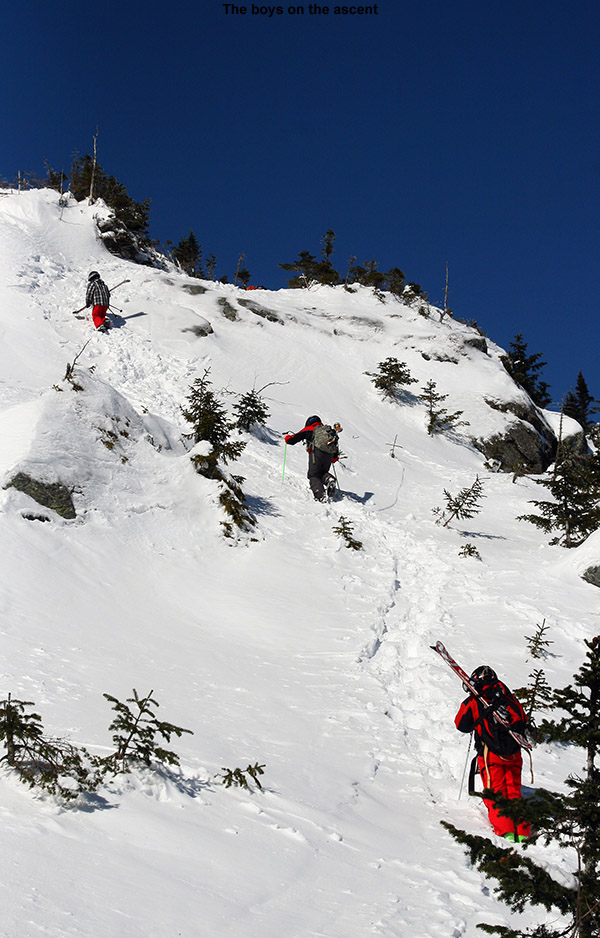
There was a decent boot ladder in place, so Ty took the lead, the other boys followed, and I brought up the rear. Ty was off like a shot, and within minutes it seemed like he was ¼ of the way up the gully and I had to reel him in a bit and tell him to hold so that the group could catch up. He was good about that, and hung out on one of the obvious stopping plateaus created by the massive room-sized boulders that fill the gully. Kenny was taking his time while he figured out what this whole “hiking with skis” process is all about, and I while I hung out with him, I gave him lots of tips on how to move efficiently in the terrain. He was floored by how fast Ty flew up the gully, and I let him know that Ty had done an awful lot of this kind of hiking and that he’d be much faster as he got used to it. The boot ladder wasn’t too bad, but in some spots you could tell that it was made by someone with fairly long legs. That set the boys at a disadvantage, but they worked it out, and I’m sure Ty was putting in plenty of shorter steps that they got to use. I did get to express to them how if they’re ever the first to set the boot ladder, shorter spaces between steps are the way to go, as they work for everyone.
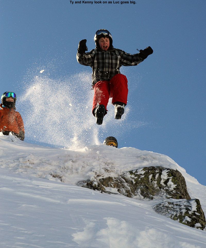
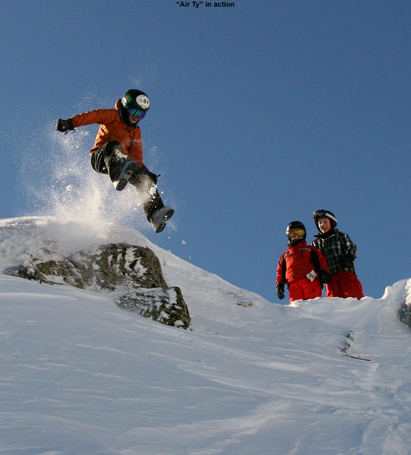
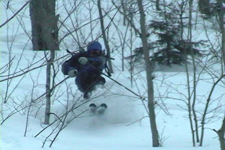
As we climbed higher in the gully, Kenny was very impressed by the views, and I told him how they would just keep getting better with every step. Kenny really started to catch his groove with the hiking when we got into the upper, less steep half of the gully, and he commented on how much easier it was getting. Once into the upper half of the gully, Ty and Luc quickly gained the ridge line, and it wasn’t long before the rest of us caught up and we were there. The wind was minimal and the sun was warm, so the boys immediately started to explore the immediate area above the gully. I shot a few pictures of the accomplishment, and then came the highlight of the trip… the jumping.
It was jumps, jumps, and more jumps!
There hasn’t been much snow to set up a big cornice along the ridge, but there was at least a little bit of one, and more importantly, plenty of snow deposited just below on the leeward side of the ridge. I can’t recall who suggested it first, but the boys quickly got into a session of leaps, slides, tumbles, and bomb holing, all thanks to the deep snow deposited below the ridge. I’d say they had a good half hour session of jumping before I reminded them of the time and pointed out that we weren’t going to get in much additional skiing today if we didn’t get going. The boys were able to pull themselves away, and after a few snacks, we started our descent of the gully.
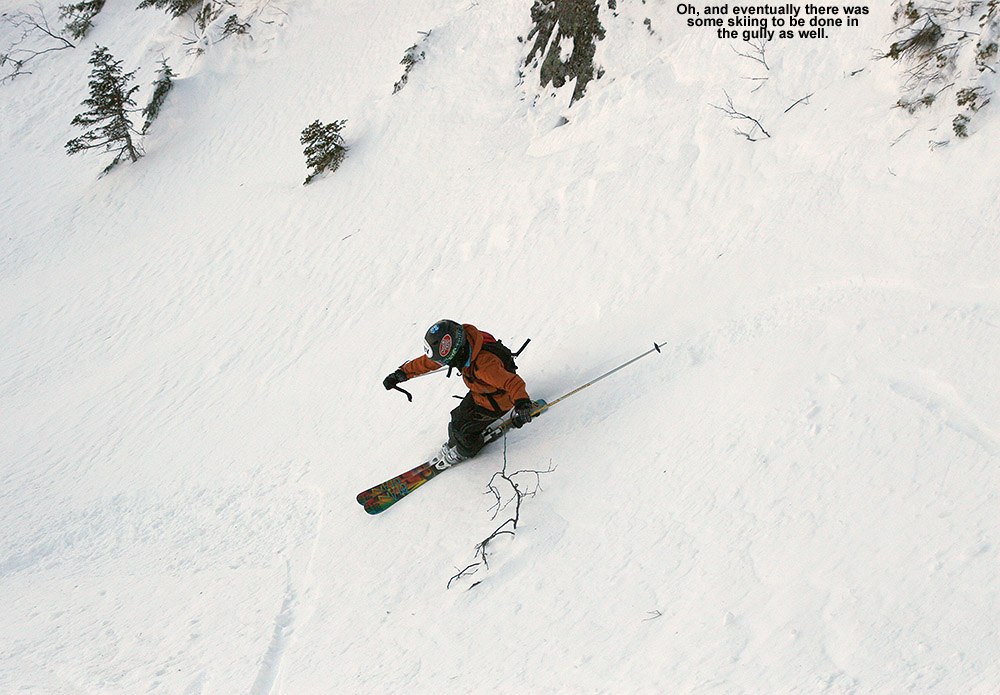
Finally, the boys made the ski descent of the gully.
The snow conditions were actually somewhat challenging, with a few pockets of soft snow, but a lot of wind slab, dense snow, and even pockets of leftover rain crust. The boys really showed their technical abilities, applying a range of techniques to take on some impressively steep, tight, and scratchy lines down the gully. I kept my eyes peeled for other options off to the skiers left, but with the current snowpack, nothing immediately jumped out that was worth pursuing. So, the boys finished their run right down through the Cliff Trail Gully itself, and it was quite impressive.
Of course, one great part about a run down from Mansfield’s alpine areas is that you have an entire run of 2,000+ vertical feet still to go. The boys chose Mac and Cheese, which actually seemed sort of tame after what they’d just done. We followed that up with some trees and bumps on Lower National. We also had time for one more run over at Spruce Peak once we got back. Actually, despite the time taken up by the hike and the run down the gully, I’m glad the boys spent a lot of time up there, because in general, the conditions on piste were pretty unimpressive. The off piste snow in places such as the Nosedive Glades was reasonable packed powder, even if well packed after this past week with minimal new snow, but trails with snowmaking and high traffic are really quite icy. There’s powder in the trees, but naturally it’s getting harder to come by at this point, and the boys weren’t really missing out on too much down below. Luc even commented on how he didn’t like the snow when we were down on Lower National, so he’s definitely refining his preference for good snow. Fortunately, it looks like we might get some storms this week, so hopefully we’ll have some softer conditions next weekend. Hopefully we’ll be back at Stowe for more fun in the snow.
“If someone had asked me about ski choice for today, I would have just said to take your fattest skis, whether they’re brand new or not.”
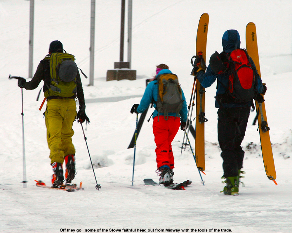
The front came through overnight as expected, dropping about an inch of snow down at our house, and more in the higher elevations. Things seemed to have come together, so I decided to head out to Stowe for an early ski tour. Temperatures were generally in the mid 20s F as I traveled through the mountain valleys, and there were no issues with the roads until I started climbing up toward the mountain around 1,000’. Above that elevation I found enough packed ice and snow that it warranted a bit more cautious driving. At the Midway Parking Lot (1,600’), the temperature was 20 F and there was light snow falling. There was the usual crowd of early morning skiers heading out and returning from the slopes, and I suspected it would be easy to find a nicely established skin track on any of the typical routes.
Heading out from Midway for turns
Since our last outings a couple of weeks ago focused on the Gondola side of Mansfield, I decided to mix it up this time and took the well established skin track that headed up Nosedive. It was well packed, and made all the sweeter by the fact that for much of the ascent there was a parallel boot pack available for anyone hiking without skins. The snowpack increased very quickly with elevation on the bottom half of the mountain, and I found the following depths during my ascent:
1,600’: 4-6”
2,000’: 8-10”
2,500’+: 12-18”
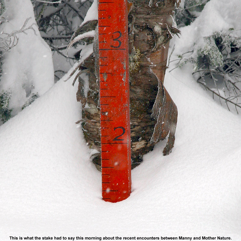
Above ~2,500’, I was essentially well into the deep stuff, and the gains in snow depth weren’t huge beyond that. Of course, when you’re already talking 12-18” of snow with plenty of substance to it, the lack of additional increases isn’t a big deal. At the top of Nosedive, I continued my ascent up the Toll Road for a few more minutes to check in on the depth of the snowpack at the fabled Mt. Mansfield Stake. At ~3,700’, the stake showed at least 17” of snow, and I generally found 18-19” there when I probed on the edge of the Toll Road itself, so indeed the snow depth up there was right around a foot and a half.
It’s really a nice sheltered area up along the road by the stake, and since the snow wasn’t perturbed by wind, you could definitely get a sense for where the snow stood with respect to quality. Indeed that quality was looking very good. As one would expect with the latest round of fluff, the snowpack was right side up with the lightest snow on top, and it was primed and ready for some turns. Big, dendritic flakes were falling while I was there switching over for the descent, and I stood and savored the moment for a while before pushing off down the road. I crossed over toward the Fourrunner Quad, and the summit area was awash in manmade snow. I didn’t even see that many guns going up there – I think the resort has already been able to hammer that area with manmade snow with the cold temperatures we’ve had.
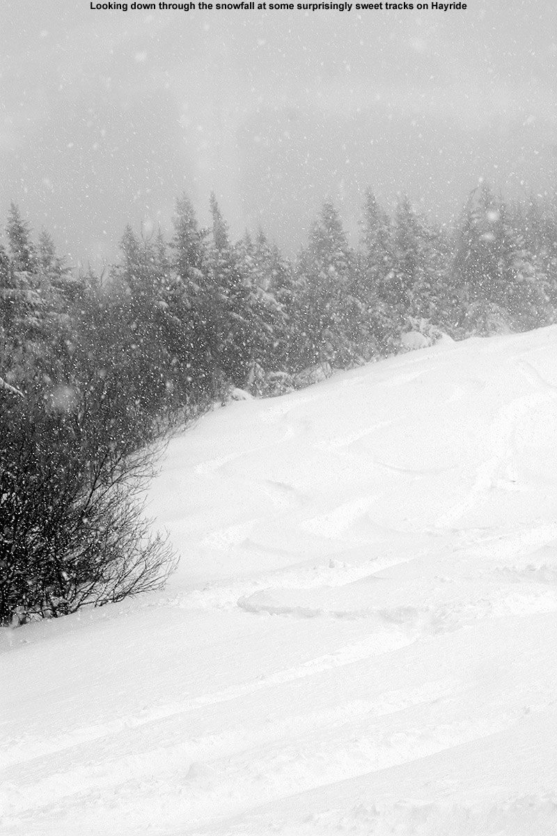
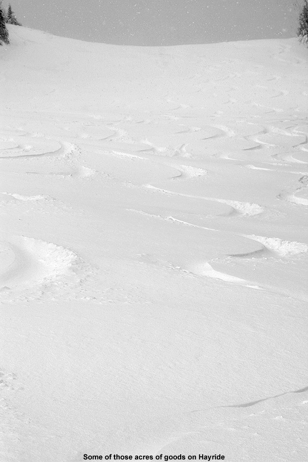
Hayride today
So now I’m left with just one more thing to discuss, the pièce de résistance for the day… the descent. While ascending Nosedive, it was clear that there had been a huge bolus of snow dropped above 2,500’, so coverage wasn’t going to be an issue. Temperatures were certainly not in question either, since it must have been somewhere in the teens F. That left the aspects of snow density and the effects of the wind, and based on the turns I was seeing by people descending Nosedive, it looked like the skiing was going to be fine, even if not sublime. But, I suspected I could do better. There had definitely been some wind on Nosedive that appeared to have packed out the snow a bit. With that in mind, I decided to roll the dice and check out another descent route – Hayride. I’d had good luck on Hayride back on April 10th of last year, when Mt. Mansfield got laced with over two feet of dense, resurfacing snow. It was actually the challenge of that snow on Telemark gear that was one of the final nails in the coffin in convincing me to finally get some fat, rockered skis for Telemark use. I could already tell that today’s snow conditions were nothing like what I encountered on that April outing – with the new fluff, this snow was notably drier. I hadn’t actually thought that it would be anywhere near the quality of what we had last November on the 30th, but after a few turns on Hayride I found that it was certainly in the same league. And indeed we’re talking quite the league – Hayride was sheltered from the wind, so turn after turn after turn I was able to push hard on the deep snow. It gave way, let you sink in, but pushed back with just enough force to keep you from getting to the ground. With 115 mm underfoot and judicious line choice, I think I touched down twice on something other than snow on the entire descent. Just like last November, the AMPerages were totally in their element, letting me play around in the deep snow on a remarkably stable platform. They helped out immensely with fore-aft balance, and I can recall some specific instances where I was saved from what easily could have been a face plant. If someone had asked me about ski choice for today, I would have just said to take your fattest skis, whether they’re brand new or not. Today, a combination of fat skis with the available snow would be plenty to keep you safely above most underlying obstacles. You’d probably end up having a heck of a lot of fun as well.
“…you didn’t have to worry about hitting anything underneath and you could just let it rip.”
Saturday arrived with a nor’easter developing just like the weather models had suggested. For folks that had outdoor, warm-weather plans for the big holiday weekend, you almost couldn’t find a nastier combination of weather. Temperatures were in the 40s F, and there was plenty of wind and rain. We wondered if we were going to have to turn the heat back on in the house. Reports began to come in about the snow in the mountains, and by mid afternoon, Whiteface was already reporting that they had received 18” of new snow. As the afternoon wore on, even valley temperatures fell down well into the 30s F in many places in New England, and fairly low elevation spots began to report snow mixing in with the rain. Although we weren’t getting any snow down to the low elevations in our area, we lost power from about 8:30 P.M. to 9:30 P.M. for some reason, so we headed off to bed early and decided to see how things were going in the morning.
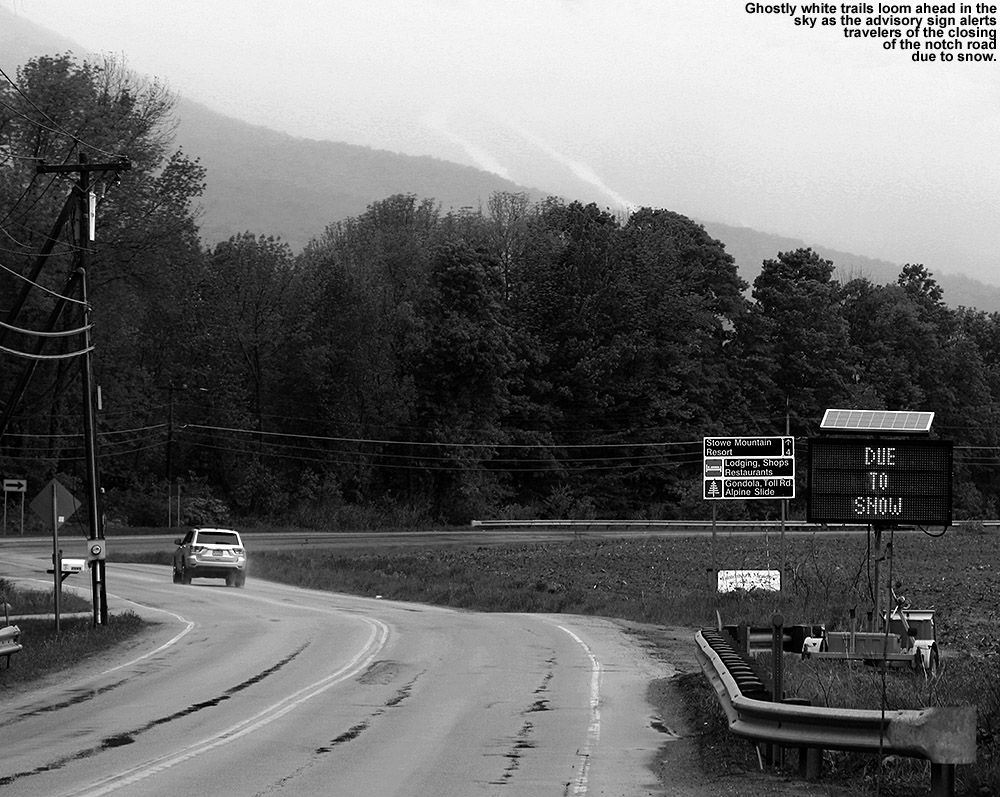
Snow closed down the road through Smuggler’s Notch today.
I made my morning CoCoRaHS observations at 6:00 A.M., and after checking back in on the weather board and looking at some of the mountain web cams, I decided to head to Mt. Mansfield for a ski tour. I couldn’t tell quite how low the snow line had gotten, but it was still below freezing in the higher elevations, and the precipitation had continued through the night. There was a good chance that a nice shot of snow had accumulated on Mt. Mansfield. I didn’t try convincing E or the boys to try to join me, since they were all still in bed, so I got into my ski clothes, let E know that I was on my way, and loaded up the car with my gear. I don’t typically find the ski gear vying for space with the baseball stuff in the back of the car, but it definitely was today. I headed off to the mountain around 7:30 A.M. or so, and temperatures throughout the mountain valleys in the Waterbury–Stowe area were in the lower 40s F on my drive. The precipitation was generally light rain until roughly the point where the electronic sign indicates the status of Route 108 through Smuggler’s Notch, and not long after that, the rain became much heavier. The sign, by the way, read “NOTCH ROAD CLOSED… DUE TO SNOW”. The road through the notch tops out near 2,200’, so clearly the snow was accumulating at that elevation on paved surfaces. The temperature remained in the lower 40s F until that final rise above The Matterhorn to Stowe Mountain Resort, where they dropped into the upper 30s F.
“You could do laps up there from 2,500’ to 3,600’ and think it was midwinter.”
I parked at the Midway Lodge (~1,600’), where the temperature was in the mid to upper 30s F, and the precipitation was generally snow, but certainly some rain as well, and the snow that was falling was of course incredibly wet. It was pretty nasty at that point, with 25 MPH winds and driven wet snow/rain. The snow wasn’t quite accumulating there, but it was close, and you could see the accumulations just a few hundred feet up the trails. The weather was nasty enough that I left my lens hood on my camera in its protective orientation, even when it went back in my pack. I rarely feel the need to do that, and typically flip it back around for storage, but that speaks to just how wet and windy that snow was to make me take that extra step to minimize the amount of precipitation getting on the lens filter.
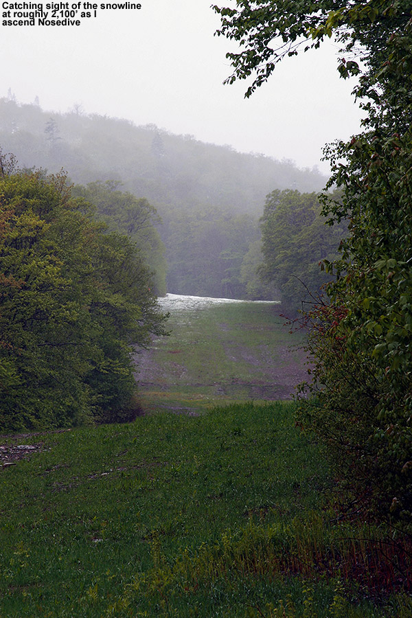
Snow line in sight on Nosedive at 2,100′
In the Midway parking lot there were a few dozen vehicles belonging to skiers, and most of the people were heading up Gondolier, but my initial ascent was via Nosedive; it’s often a good bet for decent snow coverage and preservation in these early and late-season storms. Also, based on what I saw in the report from AdventureSkier.com last Sunday, it looked like there would be some decent base snow left in case the new snow depths were marginal. The first traces of snow accumulation on the ascent were at 1,800’, by 2,100’ there was generally complete coverage of the trail, and by ~2,200’ the depth was a couple of inches and it was consistent enough that I switched from hiking to skinning. Even with those couple inches of snow, I was beginning to experience some occasional slipping as I hiked, so it was nice to get the skis off the pack and on the snow where the skins had beautiful traction. There was a faint skin track from an earlier ascender, but it was intermixed with some of the descent tracks of skiers and a bit hard to follow. I met up with another guy that was making the Nosedive ascent, and we chatted a bit about skiing as we made our way up the mountain. He was just hiking in his boots with his skis on his back, which seemed like a bit more work as the snow got deeper and deeper, but it didn’t appear to slow him down too much. Listed below are the snow depths I found on the ascent of Nosedive with respect to elevation:
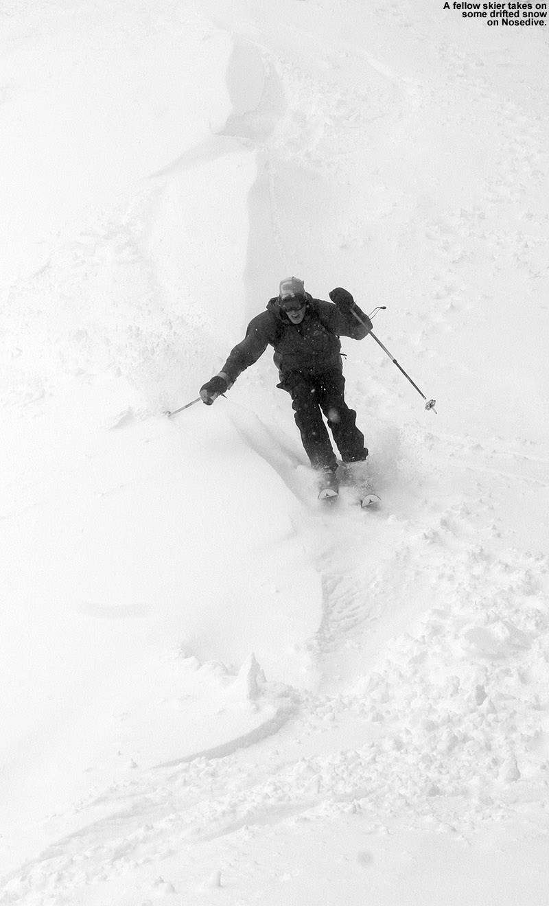
We stopped our ascent at 3,300’ because as we approached the switchbacks at the top of the trail we got some beta from a couple of skiers coming down Nosedive – they indicated that everything above that elevation in the switchbacks was scoured and really not worth it, and indeed that was obvious once we got to the landing below that final switchback at 3,300’. I’m going to call the average snow depth there 10” to be on the conservative side, but there were plenty of areas with 12”-15” of snow; there was just variability due to the effects of wind deposition. I stuck my measurement pole right in the snow in the center of that landing, and found 15” of snow depth. The guy that had ascended with me headed up just a bit higher to catch some turns along a drift of snow, so I pulled out the camera and got some action shots as he made his way down.
I didn’t get his name, but he had quite a blast ripping up the powder on Nosedive today.
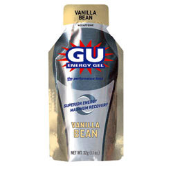
Before beginning my descent, I downed a packet of GU Energy Gel to see if it would provide that extra boost of energy to my legs to permit proficient and aggressive Telemark turns. I’ve noticed that after fairly long and/or quick ascents, my legs are often still recovering, and not to the stage where they can handle a lot of rigorous Telemark skiing right away. Alpine turns are typically no problem, since they’re easier and more stable to begin with, and after decades of alpine skiing, my muscles have the memory to really let them do it efficiently. But those Telemark turns take a lot more work, and it seemed like a little extra boost of quick energy would get me where I needed to be. So, I took a cue from the boys, who like to have a GU when they’re starting to fade while we’re biking or skiing – the Vanilla Bean flavor is a favorite among all of us. I usually don’t find that I need to worry about having enough energy on outings with the boys along; the pace is so slow that E and I usually don’t get drained. The boys certainly push themselves though, often needing some sort of recharge due to their smaller energy reserves, and when that’s the case, it’s GU to the rescue. On bigger, faster paced outings by myself though, I also feel the drain, and today I wanted to give a recuperative GU shot a try. I had the GU just a few minutes before my descent, and it absolutely worked. It helped give my legs that quick energy that they craved, and they had no trouble making Telemark turns. It was great having maximum powder to drive the legs, and while there’s no way to know exactly how my legs would have performed without the shot of GU, it was certainly my hero for today. I can still remember when I first learned about those energy gels back in the early 2,000s when Scott and Troy and their Dirtworld.com mountain biking team would use them. They’d strap them to their handlebars and down one on each lap to keep their energy up. With the way it performed today, I think a shot of GU before each earned descent is going to become part of the routine.
“There were plenty of
untracked lines to ski,
and it was dense, wall-
to-wall snow…”
As for the snow conditions, indeed there was some leftover base snow on Nosedive, and that offered up great turns, but the new snow itself was extremely dense (probably 12-14% H2O or so) and as long as there was enough of it, there was no need for previous base because it kept you off of anything below. I caught some beautiful bottomless powder on the skier’s left below the switchbacks, and then a lot more on the skier’s right along the edge of the trail. The Telemark turns were definitely flowing, and despite the fact that it was dense snow that could easily have been challenging to ski, it wasn’t. I immediately thought back to that storm last year on April 10th. Mt. Mansfield picked up more than two feet of dense snow that covered everything, but it was quite a challenge to ski on the Teles. Sometimes you would punch through the snow too far, perhaps with one ski, making lateral balance tough, and fore-aft balance was also extremely challenging. It’s possible that there was snow of varying densities in that storm, with some less dense snow underneath the topmost layer. That’s “upside down” snow, which is typically more challenging to ski. It was after that storm that I really decided that I wanted some fat, rockered Telemark skis for powder, and eventually got the Black Diamond AMPerages. I can only wonder how they would have performed in that storm – they would have been nice today, but being unsure of the snow depths I went with my older Atomic RT-86 midfats, and there were no issues. Really, the most challenging aspect of today’s skiing was negotiating areas of thinner snow as you dropped in elevation. I was actually quite impressed with the quality of some of the powder skiing on Nosedive today, but little did I know it wasn’t even going to hold a candle to what was in store over at the Gondola.
22″ of new snow up at the Cliff House today
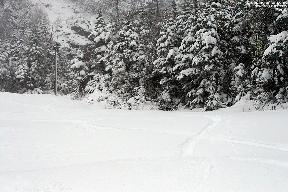
I had no time limits, and plenty of energy left in the tank with the shortened ascent, so I skied down to the junction of Nosedive and Cliff Trail, and continued my tour by skinning up Cliff Trail. Within a few moments of starting my ascent, it was obvious that snow depths were substantially greater on Cliff Trail than they were on Nosedive at equivalent elevations. I wasn’t sure if it was because I was heading toward the Gondola, or because Cliff Trail offers better protection from the wind, but coverage was deep, wall-to-wall. Unlike what I’d seen on most of Nosedive, there were no signs of whatever lay beneath the snow. It wasn’t an illusion either; the depth at 3,000’ on Cliff Trail was 11”, vs. the 8” on Nosedive. The snow just continued to increase as I ascended toward the Gondola, there was 12”+ by the junction with Perry Merrill at 3,400’, and 12” – 15” easily up at the Cliff House. That’s on the conservative side for what you could find up there, and in general the snow depth was somewhat deceptive because you didn’t sink much into the dense snow. But right in the middle of Perry Merrill just beyond the Cliff House I measured 22” of new snow in flat terrain with no drifting. The usual measurement off the top of the picnic tables was deceptive as well – there was about a half foot of snow on the tables, but you could tell that the snow was much deeper because the table’s seats were just about buried. I measured in the open space between the tables and got a depth of 18”, so presumably the tops of the tables didn’t accumulate the snow well due to wind, melting, or some other effect. Here’s the summary of the depths I found on the Gondola side ascending via Cliff Trail:
“…at times it was dense enough that you’d be smearing turns right on the surface.”
I had another GU and got ready for my descent. Even that first steep pitch of Perry Merrill had great coverage comprised of that dense snow. Typically you’d sink in a few to several inches, but at times it was dense enough that you’d be smearing turns right on the surface. It took a moment to adapt when that was happening, but somehow the variability in the turns didn’t seem to disrupt the flow of the skiing – it was just really fun. I almost headed back down Cliff Trail since the coverage was so complete, but there were already a couple of tracks on it, and it’s fairly narrow, so I opted to check out Perry Merrill instead. I was hoping it would live up to the coverage I’d seen on Cliff Trail, and indeed it was just as good, if not even a bit better. There were plenty of untracked lines to ski, and it was dense, wall-to-wall snow, all the way down to 2,500’. You could do laps up there from 2,500’ to 3,600’ and think it was midwinter. The snow certainly wasn’t fluffy VermontChamplain Powder™, it was dense Sierra Cement, but it wasn’t wet or sticky. It made for plenty of base and just skied really well – it was right near the top on quality that I’ve experienced relative to many similar early and late-season dense-snow events. Sinking into the snow only a few inches or so was inconsequential compared to the fact that you didn’t have to worry about hitting anything underneath and you could just let it rip.
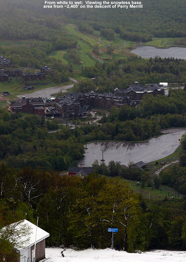
The view from white to wet
I stopped my descent at around 2,300’, as the snow was down to about 4” and it was getting notably wetter. You could probably go down to around 2,100’ easily if you had your rock skis. I hiked down the last 700’ back to the Midway Lodge, and the last vestiges of snow disappeared right around 1,800’ just like I’d seen over on Nosedive. The precipitation was snow down to just a couple hundred feet above the base, and back down at the lodge it was mostly rain with some snow mixed in at times. There were some really good bursts of snow on my descent, even in the lower elevations. The temperature had increased a few degrees to ~40 F at the base, but it was midday at that point, so that was still quite impressive.
Overall, I was really excited about how my equipment and supplies performed on this tour. My Gore-Tex did its job in keeping me dry, despite the driving rain and snow. My skins held like glue even in the wet snow, and hiking both up and down in my Telemark boots was a joy. I remembered to put them in walk mode for the walking sections (and put them back in ski mode for the descents) and it was almost like being in my hiking boots. And then there was the GU. It really quickened my recovery for the descents, and I’m going to be keeping that on the tour menu going forward. The boys won’t be able to borrow GU from me as easily though when they need it. While the GU certainly did its thing, I’m sure my stop off at Dunkin Donuts to fuel up before the tour also helped. I was feeling so great when I got home at midday, that I was ready to go for another round of skiing if E and the boys wanted to. It was still nasty and rainy outside, and not really conducive to doing too much else, but we had some fantastic winter powder skiing sitting up there in the high country. I couldn’t convince them to go though, so they unfortunately missed out this time. We did get some quality time indoors though, which I’m guessing a lot of families were doing this weekend. Ty, Dylan and I had a great round of “The Settlers of Catan” while E did a bit of shopping. It was quite a storm though, with Whiteface and other areas of the high peaks really cleaning up and putting out some amazing pictures.
…and this is what you get for Memorial Day
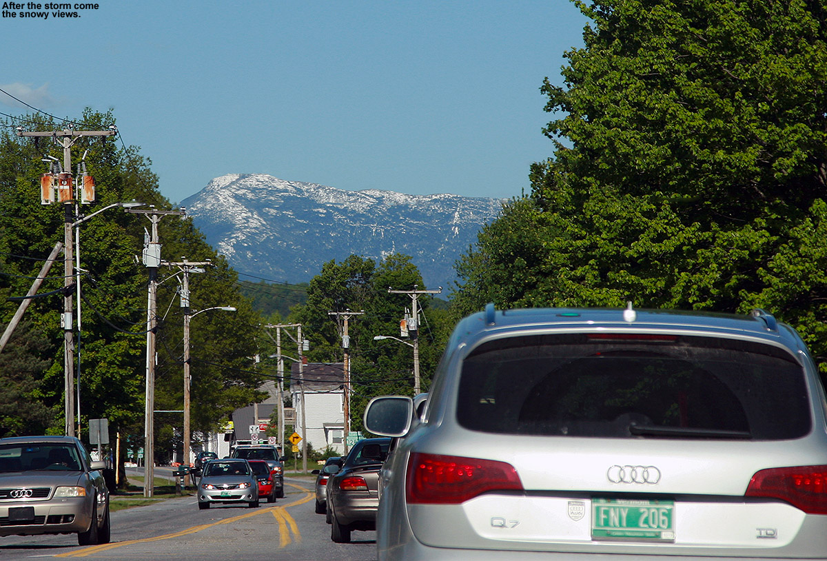
Monday update: The clouds cleared out today to produce crystal blue skies, and naturally that revealed some amazing vistas of the spring foliage and snow-capped peaks everywhere. Mt. Mansfield and Camel’s Hump were topped with white, shimmering in the strong sun of late May, and the high peaks of the Adirondacks were brilliant. We traveled around from Waterbury to Vergennes to Cambridge doing various activities, so we took in numerous vantages of the Greens and Adirondacks. It turned out to be a spectacular Northern New England Day for the holiday, almost as if Mother Nature was trying to strike as sharp a contrast as possible against the recently departed storm.
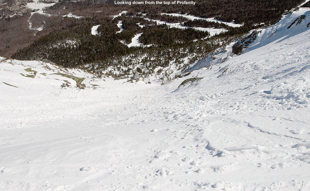
Looking down from the top of Profanity Chute at some nice winter snow
Today turned out to be a day of actual “Alpine Touring” in the high elevations of Mt. Mansfield. Although Stowe picked up a foot of snow earlier this week, the freezing level eventually rose fairly high over the past few days, and that brought the lower elevation snow surfaces back into spring time cycling. There wasn’t going to be much spring softening of the snow today though – highs in the Bolton Valley Village at ~2,100’ were predicted to be below freezing, and up in the peaks the temperatures weren’t supposed to get out of the 20s F. That sounded like a frozen granular recipe for those elevations that had gone above freezing, so it seemed like a prime time to head to the high elevations up near 4,000’. I’ve been waiting for a day to get up into the alpine areas of The Chin so that I could explore some lines to ski with the boys, and today’s conditions were the perfect excuse. It was crystal clear, and visibility is always something to consider if you’re going to go exploring around above tree line.
“The snow was definitely all winter up there…”
I laughed to myself as I was driving to the mountain around midday and saw that even in the valleys the temperature was below freezing. There definitely wasn’t going to be much in the way of softening today. If the alpine areas had been warmed, it was going to be a short outing, because there was no need to play around up there on bad snow that had been refrozen. Despite the sub-freezing temperatures all the way down to the valleys, there was still the occasional reminder of spring. As I was driving near The Gables Inn on the Mountain Road, I was momentarily distracted as a red fox was chasing a skinny, dark black animal (perhaps a mink) all over the place alongside and across the road. The mink didn’t seem especially scared, and it actually wasn’t all the much smaller than the fox; it was almost as if the two were simply engaging in some sort of springtime frivolity.
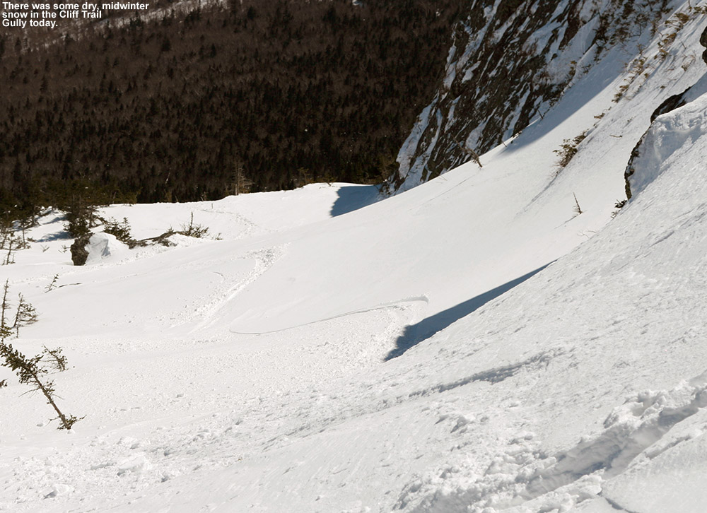
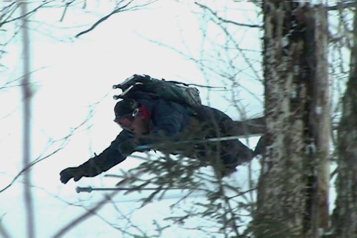
I parked at the Midway Lodge, hopped on the Gondola, and began my hike right up above the Cliff House once the lift dropped me off. I’ve hiked that route in the fall before with E and the boys – it’s the hiking route called Cliff Trail (not to be confused with Stowe’s ski trail called “Cliff Trail”. There’s quite a dramatic difference in what one experiences up there in the warmer months – the trail wraps around, under, and over 20-foot tall boulders and other sorts of obstacles. However, in the winter it’s essentially buffed smooth with meters and meters of snow. That’s pretty amazing, and speaks to just how deep the snow gets up there. On my ascent from the Cliff House at ~3,600’, the surface of the snow initially had a thick layer on top that seemed to be some sort of melt and/or wind crust, but at around the 3,800’ level, the snow began to get better and pockets of powder were starting to appear. Before I knew it, I’d hit the ridge around 4,100’. Relative to similar warm weather hikes, it felt like no time at all had passed, and it’s a testament to just how much easier it is to hike that route when all the huge rocks are covered with a nice, smooth surface of snow. I did get to follow someone else’s boot pack though, and that certainly helped with the pace.
The Cliff Trail Gully today offering some winter snow
I spent a few minutes on the ridgeline, and then dropped in for some turns. The snow was definitely all winter up there, I’d say the bigger enemy had been the winds. I got in some nice turns, and once I’d dropped a couple hundred feet and the snow quality started to deteriorate, I popped my skis back on my pack and headed skier’s left to see where it brought me. The travel was very easy with all the snow, and I quickly came to the next gully over. I hiked up that one to the top, but didn’t find the snow to be up to the best stuff I’d found over in the Cliff Trail Gully. I made a short descent in that gully, just enough to get me access to keep moving to the left, and then came to a third gully. By the time I topped out in that one I was actually starting to get close to The Chin, so I decided to just continue up and poke around to see what descents might have good snow.
I checked out both Profanity Chute and Hourglass Chute, and they both appeared to have good winter snow in them. I haven’t been down Hourglass since I skied it about 15 years ago, but as I watched people side-slipping their way through the crux, it didn’t seem all that appealing. The snow quality looked decent, it didn’t quite have the appealing look that Profanity did, so I ended up going down Profanity Chute for my descent. Taking that option was a bonus as well, because I don’t think I’ve ever skied it before. It’s definitely a fun line, and it’s not excessively steep at probably 30 degrees or so, it gives you a nice ride with an alpine feel. The snow was generally packed powder, although there were a few slick spots in there. I cut left and followed the main line down through the subalpine areas, and outside the main track there were good shots of powder – I was often finding depths of 10 to 11 inches and it was quality stuff. The snow definitely started to deteriorate below 4,000’. It was mostly in the main lines where there had been traffic, but those spots were certainly slick. Following the lower connection of the chute through the evergreens was notably more challenging than the crux up at the top, in part due to the firmer snow in those lower elevations. I made my way back toward Chin Clip, and connected onto Gondolier. Conditions were pretty bad as far as I was concerned, it was a lot of frozen granular, with the best relief from that being the loose granular that people had pushed around. I’m not sure how much day tickets cost at Stowe today, but I’m surprised how busy the mountain was. The parking lots were reasonably full, so apparently there are plenty of folks out there that didn’t mind the conditions. We’re heading back to Stowe tomorrow for BJAMS ski program, and the potential is there for some warmer temperatures. It feels like we’ll either need some of those warm temperatures, or enough new snow to soften up the surfaces.
A close up view of the Google Earth/GPS map of today’s tour – click for the full size image.
May turns today on the Haynes trail at Jay Peak Resort
The boys and I had visited Jay Peak exactly one month ago today to take advantage of the 2+ feet of upslope snow that a cutoff low pressure system had dropped on the Northern Greens. It was great to catch up on all that had happened at the resort over the past couple of seasons, and since that visit I’ve been checking in on the Jay Peak website to keep up on the latest news. I’d looked into lodging deals for that trip with the boys last month and hadn’t found quite what I was looking for at that point, but over the past couple of weeks they’ve been promoting a Mother’s Day brunch/lodging/water park package that looked quite attractive. Prices started at $159 for brunch and lodging for two, and options were available to add on additional people and water park access.
I mentioned the idea to E earlier this week, and she thought it was a possibility, but we let it simmer for a while as we thought about what we might do with my parents over the weekend. The boys caught wind of the Jay Peak idea, and they were of course gung ho about the whole thing, since it included visiting the Pump House Waterpark. Finally, after finding out yesterday that my mom was heading with my sister to New York for the weekend, we decided to go ahead and book a room at the resort. Since it was technically Mother’s Day on Sunday, we made sure that it was what E wanted to do, and she was excited about the idea. I called up Jay Peak, spoke with a representative, and they set us up with a nice room in the Tram Haus. The package included the Mother’s Day brunch at Alice’s Table, two days worth of access to the Pump House Waterpark, Ice Haus Arena access, and apparently a collection of other goodies that we saw listed on the website. Another very cool part of the trip was that there was still snow for skiing. Earlier in the week the resort had posted a photo of all the snow left at the Stateside area with the caption “May snow for the motivated”. The snow looked good and I was motivated to get some turns, and I suspected that I could get E and the boys motivated as well.
After taking care of some yard work and other stuff at the house in the morning, we headed off to the resort around mid afternoon today. Temperatures were around 70 F, and skies were partly clear with some clouds building in ahead of precipitation that’s expected overnight. As we crested the top of Route 242, which is somewhere above 2,200′ in elevation, the effect of the altitude was very obvious as the temperature dropped well down into the 60s F. We checked in at the Tram Haus and found our room there to be quite impressive; various locally crafted materials were used in the construction, and the craftsmanship seems first rate. Our room was a suite-style setup, with a full kitchen and a good size living area that contained a pull-out bed for the boys. Our balcony looked out right over the slopes, and we could even see the snowy slopes over at the Stateside Area.
Ty takes in the view of the resort and the snow at the Stateside area from our balcony at the Tram Haus Lodge.
After getting settled in the room for a bit, we hopped back in the car and drove over to Stateside to make some turns. A quick look revealed that the Haynes/Mont L’Entrepide route seemed to have the most continuous snow, so we made use of the access road to the Jet Triple Chair, which allowed us to drive right up to the base of the runs. It was nice dry grass there at the bottom of Mont L’Entrepide, and made for a great place to prepare the gear and get suited up. There was a brisk breeze at times, and being Jay Peak, the weather was doing its own thing, so we even had a few spits of rain among the mixed clouds and sun. We were thankful for the breeze when it was there, because black flies were already starting to appear. They didn’t seem to be biting much yet, but they were still annoying when the breeze didn’t keep them away.
We saw beautiful wildflowers appearing on Jay Peak’s slopes.
We hiked for the first couple pitches of the ascent with our skis on our packs, and E and I took care of carrying the boys skis so that they could enjoy the ascent. We saw a couple of other guys making the ascent as well, and climbing on the skier’s right seemed to be the most practical route. Small patches of snow started to appear almost immediately as we headed upward, and then after passing a one relatively large area of snow, we were able to put on our skins for the rest of the ascent. The snow was generally decent corn, although there were some areas where it was icier – we tried to avoid those areas on the ascent because they didn’t offer the skins very good grip. One didn’t really need an established skin track for the ascent, but we generally followed what was set up by other skiers. The continuous snow reached to just about the top of the trail, and for the last third of the ascent, E was really blazing the path and set up some a skin track with nice switchbacks.
Ty getting in some Telemark turns on Haynes today
We enjoyed some relaxing time at the top of the ascent on Haynes as we soaked in the views of the resort and the wilds of the Northeast Kingdom. The sun was in and out of the clouds, but the temperatures were perfect, and with the wind picking up as we ascended, any black fly issues disappeared for the most part. The Haynes Trail is actually quite steep, so we were excited to see if the boys were going to go for some Telemark turns, or simply stick with alpine turns. They actually mixed it up, with Ty making Tele turns throughout much of the descent regardless of pitch, and Dylan throwing them in where he felt comfortable as the pitch decreased a bit. There was some really nice snow near the top of Haynes on the skier’s left – some fun, steep corn snow that let you push hard into the turns. We did our best to avoid the dirty, icy areas, and we still had to hit some, but they were manageable. We were able to make our way to the end of the last big patch of snow crossing just one notable gap, and then we strapped our skis back onto our packs and had about a five-minute descent to the car. It was definitely fun to get in some May turns today, because even though May skiing is pretty standard most seasons, the combination of low snowfall and incredibly warm weather this March depleted the snowpack much quicker than usual.
A view of the Tramside Base Area from the Stateside Summit
The boys were actually in very good spirits for today’s ski session, because they knew that a trip to the water park was coming right on its heels. We made it back to our room at the Tram Haus, got suited up for swimming, and headed out quickly to the water park because it was actually getting late. One very cool thing we discovered today is that although the Pump House Waterpark is in the Hotel Jay, even if you are in the Tram Haus Lodge, you don’t have to go outside to get to the water park. It turns out that the Tram Haus and the Tramside Base Lodge are connected to the Hotel Jay and water park by an underground tunnel; you never even have to go outside because the buildings are essentially all part of one huge complex. I had initially inquired about getting a room at the Hotel Jay since we knew the water park was going to be big with the boys, but it was great to find out that staying at the Tram Haus works out just as well. I’m sure this is a huge benefit to people in the winter; imagine being wet from the water park and having to head out into the elements at a place like Jay Peak. It’s actually quite a labyrinthine trip to get through the whole complex from the Tram Haus to the Pump House, but it’s fun and you get to see a lot of what the resort has to offer. You go right past Mountain Dick’s Pizza, so you can stop in if you want to get a bite to eat, and we saw that the Hotel Jay even has a big family/game room for people to use. In addition, right next to the water park there is a huge arcade. Overall it’s quite a mesmerizing place to be a kid, and the boys were really bouncing off the walls due to the dizzying array of things to do.
As for the Pump House Waterpark, it was the first time visiting for me, but E and the boys had been before so they were my tour guides. They started things off with a couple of laps in the Big River, which is the lazy-river style stream of water that encircles the area of the water park. It’s actually got a decent current, and you can ride tubes or just swim around and go with the flow. I was next introduced to the four main water slides. I joined Dylan on the “blue” water slide, where you ride on one of the inflatable tubes just like in the Big River. It’s been years since I’ve been to a water park, but man, these slides are fast! The last time I’d been on a water slide before these ones was when we were at a party back home and someone had rented one from their local water slide hire shop, it was great fun but nowhere near as big as these ones. In one section you go into complete darkness and as the slide dips and turns, it really throws you around. I was yelling up a storm on the blue slide once the darkness hit – you really have no idea which way the slide is going to go next, so you’re just on the edge of your seat. The “green” water slide has a similar setup, and Dylan and I started on our knees on our double tube – we had a pretty bad tumble in the dark section of the slide and ended up falling off our tube! It was pretty crazy, and if you’re looking for something tame, these slides are certainly not it. I was next introduced to the “orange” slide, which kicks it up a notch – you don’t ride a tube, and there are some serious g-forces if you let yourself pick up speed in that one. To finish off, I tried the “red” slide, which is called “La Chute”; it has an off-axis loop in it. Whoa, that one really is in a league of its own. You take an extra staircase that gets you up into a little room sticking out of the top of the water park structure – that’s already a message right there. You start off standing in what is essentially a clear, vertical coffin that gets closed around you, then the floor drops out from beneath your feet and you are just about free falling – that is until you start to get into the loop and you are crushed to the outer wall of the slide. It is a huge, harrowing rush of a ride. One very cool thing about our visit to the Pump House this evening was that since we were near the end of the day, we just walked right onto all the slides and there were no lines. We also visited a bunch of other attractions in the water park – one that I really liked was the bouldering wall that is perched right above the water, so that when you release, you just splash down. I want to get back to work on that one tomorrow. We finished off in the huge “Hot Springs” hot tub, which has a number of little coves that act like little secluded hot tubs of their own. I’d heard quite a bit about the Pump House from E and the boys and other folks that have gone, but I still wasn’t quite sure what my own experience would be like. Now that I’ve been, I’ve got to say that almost anyone will find something there that they’ll enjoy. I’d like to try the surfing wave tomorrow; there always seems to be at least a bit of a line there even when it’s slow, but it looks like it would be a lot of fun.
The main water slides at the Pump House Indoor Waterpark
We stayed at the Pump House right up through the 9:00 P.M. closing, and then headed back to the room and cooked up a late dinner of pasta, bread, salad, and other stuff that we’d brought from home. The kitchen in our unit has plenty of space and naturally everything you need for cooking and cleaning is available. The boys say they already can’t wait to come again, so we’ll be watching for more lodging packages. The water park really makes the trip quite unique, and it’s certainly an incentive to stay over and make it a multi-day event. It’s also nice to be able to acknowledge Jay Peak’s efforts to make the resort a place that has got so much to offer that people will really want to come here, even if they aren’t skiing. Being able to come up and have a good time, while supporting the economy in a part of the state that could really use the boost is a win-win as far as we’re concerned. We came up two years ago for the Mother’s Day brunch at Alice’s Table for a day trip, but with all the additions to the resort since then, an overnight stay was a really good fit this time. I’m sure the incentive to take similar trips will only increase as the resort’s developments continue – I can’t wait to see what the West Bowl ski terrain expansion will be like if the resort is able to continue with their plans. On a practical note, I was able to hop right on to the free wireless here at the Tram Haus and upload this report with ease. The signal was strong, and upload and download speeds were both in the 20 Mb/sec, so uploading pictures for the trip report was a snap. It was almost as good as the kind of services you can find more about online!
Sunday update: As forecast, the sky was gray this morning. There wasn’t any notable precipitation when we first awoke, but from our room we could see umbratilous clouds pushing their way down from Jay Peak to hide the upper mountain slopes. Brunch down at Alice’s Table was excellent, just as we’d experienced on our last Mother’s Day trip, and it felt like there were even more options available this time. While at brunch, the rains finally came, and that quickly evoked memories of the snowstorm that was taking place the last time we’d been eating there – we were even sitting at the same table!
Gray skies and descending clouds on Sunday morning
Our brunch was right at the start of the morning, so when we were done we had time to head back to the room and relax for a while. The boys were of course chomping at the bit to get back to the water park, but they were at least able to amuse themselves watching some TV and playing their video games. They asked me some things about league of legends boosting, which I didn’t really understand, but they seemed to know a lot about and it made them happy when I helped them. Most importantly, Mom got to spend at least some of the morning relaxing in her big king bed in the master bedroom, and the boys generally let her do that. When we finally checked out, I was still curious about all those additional perks that we’d heard about on the website. The associate at the front desk eventually realized that they were part of a coupon book, and she passed a copy along to us. Coupons are a great way to still experience a variety of activities without having to spend a fortune so we were very appreciative of the coupon book. To this day, we still use coupons and even troll sites like Raise looking for the best discount and promo codes. Who doesn’t love a saving, right?! The book we were handed was full of discounts, and I mean FULL! Indeed it’s chock full of some great Jay Peak deals, such as a family tram ride, an additional ticket for the water park, a $10 gift certificate that was good anywhere at the resort, tokens for the arcade, equipment rental at the Ice Haus Arena, etc.
Lunch at The Warming Hut snack bar
After checking out, we moved on to the water park for another session, and as we headed from the car through windy sheet drizzle, it only reinforced the fact that an indoor water park is absolutely the way to go when it comes to Jay Peak. You get the winter access of course, but at any time of year, you never quite know what the mountain is going to deliver for weather. There were a few more people at the water park today compared to last night, but the slides were essentially “walk on” again, with occasionally two or three people in front of you at the slide entry. I didn’t get a chance to try the surfing, but it looks like one of the coupons we received provides a lesson with one of the instructors, so that may be useful. I’d managed to eat well at brunch (not surprisingly), but E and the boys can’t quite pull that off, so they had some lunch at “The Warming Shelter” snack bar attached to the water park. By that point, Ty and I were done swimming, so we hung out in there while E and Dylan went back out for several more laps in the Big River. Ty and I were able to watch them from our seats as they’d float by, and we had a good time chatting and relaxing in the snack bar. It’s quite a disparity of environments when you are behind the glass there. Out in the water park it’s warm, humid and loud, but in the snack bar it was the exact opposite.
Before leaving, we stopped in at the Elevation 1851′ Family Arcade, used our coupon tokens for some skee ball, and the boys played a round on one of the video games where you ride on motorcycles. We also checked out the surf shop to see if they carried any Jay Peak surf shirts; a lot of folks (including Ty and Dylan) use those type of shirts at the water park, and they help to keep you a bit warmer if you’re going to be in the water all day. I’ve got one that I use for kayaking, which also keeps away that board rash from long days of boogie boarding, and E has been wanting one for a while. The surf shop is fairly big, with lots of Jay Peak merchandise, but we had no luck on Jay Peak-specific surf shirt. That would be kind of a neat item though, a surf shirt from a ski area. As we headed home, the sky gradually brightened and eventually gave way to partly cloudy conditions, and a check of the rain gauge at the house revealed that we hadn’t even received any precipitation while we’d been gone. In the winter that precipitation pattern probably would have meant some snow for Jay Peak, while even just an hour south at the house we would have totally missed out on it – just some off season work by the famous Jay cloud.
Looking back at the resort trails today as I head up into the alpine
The boys were more interested in planting flowers with Mom on Saturday than skiing, so unfortunately I couldn’t interest them in going out for some turns. This meant that I was on a solo outing, but the upside was that I’d be able to do a much bigger tour than I would have been able to with Ty, or especially with Dylan. The skies were clear and blue all Saturday morning on what was likely our warmest day of the spring up to that point. The temperature was already around 80 F when I pulled into Stowe’s Midway lot (~1,700’) in the early afternoon, and with the forecast for temperatures in that range, I hadn’t been too optimistic about the snow quality. My major goal was to at least get in a good workout, so I was willing to negotiate some sloppy snow on the descent if that was the way it had to be.
Snow was available right from the Midway Lodge elevation, with just a couple hundred feet of fairly flat walking on grass to get on it from the parking lot. I was immediately surprised when I got on the snow and found that it wasn’t sloppy at all; it was all corn with just the top inch or so loosened up. That’s the sort of corn that seems to provide some of the easiest turns, so I was immediately enthusiastic about the potential for a quality descent. There wasn’t much of a breeze in the lower elevations, but the snow helped keep the air temperature a bit cooler and the ascent was very enjoyable. For ascent attire I’d gone about as minimally as I felt comfortable doing, with a short sleeve polypropylene T-shirt and my ski pants with the side zippers fully open, and that worked out to be a comfortable setup for the temperature. I hadn’t made a non-powder ascent on skins in a while, and I was quickly reminded how the lightness of Telemark gear allows you to simply fly up the slopes. Before I knew it I was up at the Cliff House (3,625’) and feeling great, so I decided to keep going up into the alpine.
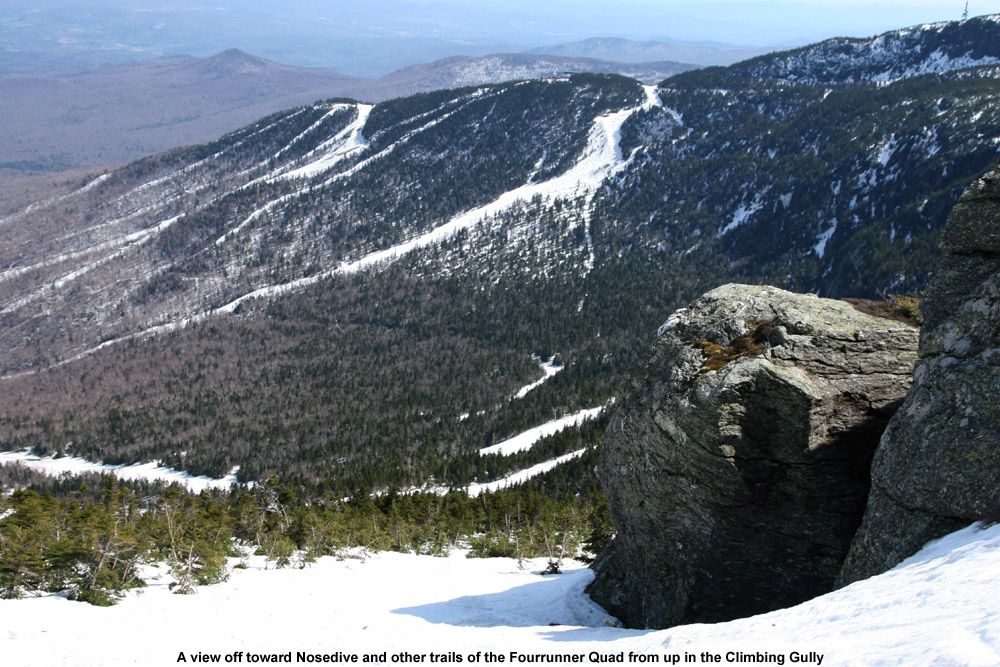
I set my skis onto my pack and hit the climbing gully. There was a bit of rotten snow in spots, and as I didn’t immediately find a boot ladder, I had visions of an inefficient, sloppy climb with lots of post-holing. I’d already post-holed a few times in the outskirts of the gully (it only took one of those to remind me to get my ski pants zipped up at least halfway) but fortunately, about 50 feet up the climbing gully I found a boot ladder made by some nice big feet. That made the going fairly smooth, and the views of the Green and White Mountains continued to improve with each step. Near the top of the gully, I ran into a guy about to descend. He had spent an overnight or two on the mountain, and said that he’d been amazed to find fresh powder on Friday morning when he’d started skiing. It sounds like along with Thursday morning, Friday morning had also been good in the higher elevations with regard to fresh snow. The downside of the fresh snow was that conditions in the alpine were still a bit sloppy. The new snow had not yet cycled to corn in the highest elevations, so it just wasn’t going to provide an optimal surface. By the time I departed from my conversation in the gully, I was moments from the Mansfield ridge line. Up on the ridge I enjoyed the new westerly views of the Champlain Valley and Adirondacks, and decided to stop in at the top of The Chin (4,395’) since I was so close. There was a small group of college students enjoying the popular leeward side of the summit, and there was a pleasant breeze of probably 15 MPH or so. The high temperature for the day at the Mt. Mansfield Stake came in at 67 F, so I suspect that the summit maximum temperature was probably close to that. Getting an April day like that at the top of The Chin is certainly a treat.
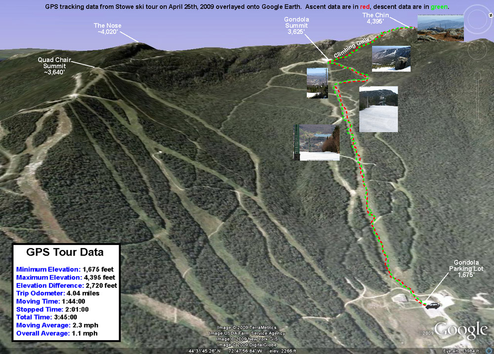
For my descent, I wasn’t able to ski right in the summit or the West Chin area due to lack of snow, but I was able to ski down the gully where the Long Trail drops away from The Chin as it heads south. It was quite a perspective to see the snow create a flat surface through the gully, when in the off season it’s a 10-foot deep chasm containing the hiking trail. I had to remove my skis to descend the very top of the climbing gully, but below that point one could keep them on continuously. As expected, the new snow up high that hadn’t fully cycled to corn wasn’t as nice as the corn snow on the bottom 2,000’, but I actually had some fun turns in the climbing gully, and it let me work on Telemark turns in steeper, tighter confines. I still had to make some alpine turns and throw in some side slipping up there since some areas were just so tight, but overall the gully allowed a good mix of styles. The crème de la crème of snow surfaces for the day was probably the top half of the Gondolier descent. There must have been very little traffic up there because most of the snow surface was just a smooth layer of ripe corn. The lower half of Gondolier still had nice corn snow, but the surface wasn’t as smooth as the top half of trail. Perhaps the lower elevations had experienced more melting that started forming aberrations in the surface. Based on my GPS data, it looks like my descent was 2,720’, not quite what you can get for vertical in the winter when you head all the way back down to Route 108, but still a decent run. There were still about 7 feet of snow at the stake on Saturday, and even though that level has dropped some with the recent warmth we’ve had, skiing should available on Mt. Mansfield for a while.
A Google Earth/GPS map of today’s ski tour up to the Chin of Mt. Mansfield – Click the image for a full size map
Jay enjoying some powder during today’s ski tour on Gilpin Mountain after Jay Peak recently received 2 1/2 feet of new snow
For years I’ve driven along Route 242 to get to Jay Peak, often remarking about the intriguing ski terrain that dropped to the road from both sides. This was always on the way to ski the resort of course, and thoughts of exploring those backcountry goodies had to wait. Since Jay Peak had received 2 ½ feet of new snow in the past few days (much more than anyone else locally for us), and it was a holiday weekend, I decided it was time to explore the goods off Route 242. This realization came to me on Friday morning when I awoke, and I soon sent out a secret message to a local band of agents informing them of a Mission Impossible. This mission, which James, Erica, and Dave chose to accept, wasn’t really all that impossible, it was more just unknown. Mission Impossible sounded fun though.
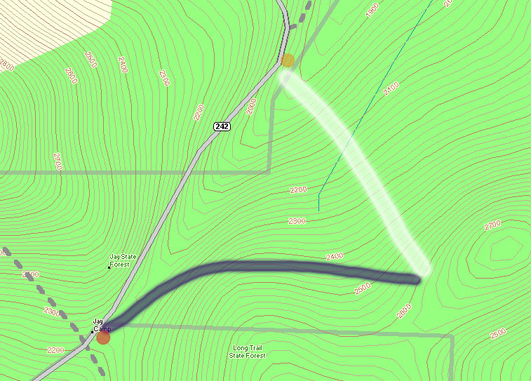
A topographic map of the Gilpin Mountain area showing Route 242 (gray) and the approximate ascent (thick blue line) and descent (thick white line) routes used during today’s ski tour
At the crest of Route 242 (elevation ~2,250′), The Long Trail crosses the road, and along with the trailhead there’s a parking area (see the red dot at the lower left corner of the topographic map provided with this report), so this appeared to be a good place to start a hike. My initial plan was to head south along The Long Trail (note on the map where the gray-dashed Long Trail heads south from the red dot) toward Domeys Dome (elevation 2,913’ – not visible on map) and ski down from there to Route 242 where we would have a second car waiting (elevation ~1,500′ – off the map to the south). This would provide a roughly 1,400′ vertical run, with a calculated pitch of around 23 degrees.
When we actually arrived to surveil the area though, we discovered that what looked good on paper didn’t look as enticing in real life. The parking at the bottom was quite far away, and the slope leveled out too quickly to a very low angle. In 10 degree temperatures and brisk winds, we gathered together in one of our cars at the top of Route 242 and consulted the maps for new guidance.
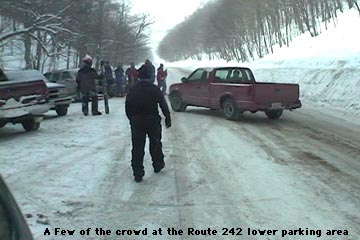
We decided to drive the car along Route 242 to the northeast (in the direction of the Jay Peak base area) as the road descended toward the resort, while we looked for potential ski lines. There were plenty of lines off to our right, as well as a second parking area for cars (yellow dot on the map) at the next low point of Route 242 (elevation ~1,950′). This setup seemed almost too perfect. I say “almost”, because unfortunately The Long Trail doesn’t go in that direction at all, and we assumed we’d have to blaze our own path through deep powder to get to where we wanted to go. We had seen what appeared to be a trail heading off in the direction we wanted, very wide (10 feet or so on average), but we were still unsure if it would work for us. As we got closer, we could see that someone already had a skin track heading that way; we’d found our hiking route.
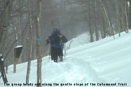
From the top of Route 242, we got our gear together, threw on our snowshoes, and headed out along the trail (our ascent route is roughly marked by the thick blue line on the map). The image of the group heading out shows the general look of the terrain at the start of the trail. I soon noticed from the blazes that this was The Catamount Trail (the HUGE cross-country ski trail that travels the whole length of the state). The upward slope of the trail was very slight, but as we continued on our ascent, Route 242 quickly fell away to our left and we could watch the vertical drop for our potential ski run grow rapidly. At an elevation of around 2,400′, we broke uphill of The Catamount Trail (following the switchbacks of another skin track) to gain some additional vertical. It turned out that other folks had been in the area today, as shown by the skin tracks, ski tracks, and the people themselves. We continued to hike up to around the 2,600′ mark, and then as the slope started to mellow out, we decided to boot up and test out the terrain. A group of about five Telemark skiers passed by on their way up, one of them deciding to cash in at that point and start his descent as well.
Dave slices his way through some branches as he encounters a brushy area on one of our ski runs.
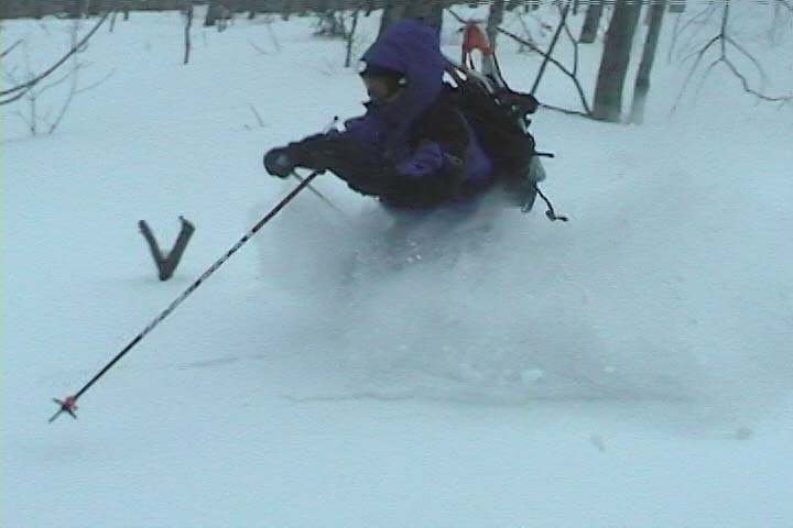
It’s amazing to think that last weekend had been a situation of rain, warm temperatures, and a refreeze that turned the entire snowpack into a solid, crusty mess. From where we were standing, it was basically bottomless powder, a situation in which removal of snowshoes or skis meant trouble standing. The pitch of our descent started off mellow, with various areas of hardwood glades and some underbrush at times. The snow was nice and light; I’d estimate its density at somewhere in the 5-7% H2O range. The slope gradually got steeper as we picked lines along the way that looked good and headed in the general direction of our lower shuttle vehicle. Our general descent route is marked by the thick white line on the map. Even with the deep snow, some areas had enough underbrush that they made picking lines difficult. Some areas we quite clear, but a bit of scouting was needed to find them. James picked direction with his usual finesse, and guided us right down to the parking area and our waiting vehicle (Dave’s pickup truck).
A scene from the lower parking area on Route 242 where many people finished off their ski runs, with skiers of all types constantly coming and going
Our total vertical skied was approximately 700 feet, which was a nice run for only about 400 vertical feet of very easy hiking. At the parking area it felt like the local version of Grand Central Station for backcountry skiing. There were numerous cars, lots of people hanging out, and skiers pouring down off of both sides of the road enjoying the powder. James said it felt like a local backcountry Mecca (in reference to the number of people). Although a few of the people were from our side of the road, most came down from the Jay Peak side, riding the lifts and then catching a beautiful long run all the way down to Route 242. Some people had cars waiting for them, some hitched rides, and some looked like they had no idea where they were. It was an awesome scene to see though, with all those folks out there enjoying the snow. I’m thankful we weren’t skiing the other side of the road though (the Jay Peak side), as the number of skiers on those slopes had even that vast amount of terrain tracked up quite well. I had always thought of heading that way when skiing Jay Peak, and had no idea how many people did it. There was a continuous flux of people coming through that area all day long, with cars pulling in, parking, leaving, people looking for rides, giving rides, looking for people that they had lost, etc. etc. etc.
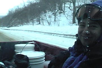
Catching a ride back up to the top of the pass in the back of Dave’s pickup truck
Using our vehicles, we shuttled our crew up to the top of the pass, and started for another run from the upper parking area. Unlike the lower parking area, there were only a few cars there, and no people. The wind was blowing and the temperature had stayed around 10 degrees the whole day, but the sun had come out for a while during our first trek, and it had made that a great hike. We had a snack in the car, and headed off along The Catamount Trail for round two. Our first run had tuned us into the lay of the land its terrain nuances even better, and now James had plans for some even sweeter lines. We hiked the same general route (much easier at this point with the presences of our tracks and those of numerous others who had been up). We cut upward off The Catamount Trail a bit earlier, and topped off near the same elevation as before. This time we found some lines that were even more open, although we did still had to pass through some brushy sections.
James helping out with some footage for our crash reel!
I’m not sure how good the ski touring in this area would be with low snowpack, since even with four feet of base, there was still brush in some areas, but it was certainly good skiing with our usual midwinter base depths. Some of the most fun we had was due to spectacular falls, with all four of us getting in on the act by diving into the powder. We shot about 30 minutes of video, hopefully enough to have a segment in this year’s ski movie. We’ll have to see, but either way, we got some of our best falls for this season’s crash reel! 🙂
My route on Mt. Mansfield today took me up toward the Sunrise trail to enjoy some early October powder.
Today I went up to Mt. Mansfield to get some turns in the snow before it started to disappear. A nice cold snap has dropped over a foot of new snow on some of the mountains, with snowfall reaching even down to Burlington. Traveling on I-89, I first saw snow on the Robbins Mountain Power Line, up around 2,000′. It was very patchy and hardly noticeable, so I was worried about how the lower elevations would be on Mt. Mansfield. Things looked up as I entered Waterbury (~520′) and found traces of snow on the ground. At the base of Mt. Mansfield (~1,600′) there was an inch or two of snow on the grassy surfaces. I hiked up in the region of the triple, looking for slopes that had nicely mowed grass for the trip down – a map of my route is pictured along with this text. At around 2,500′, the snow was over 6 inches deep so I threw on my snowshoes to make the going easier. I stopped my hike at around 2,920′ (see map) since it was time to head to work, but the snow depth had increased to about 8-10 inches. The snow was fairly heavy (~11% H2O or so), but light enough to make powder turns. I’m sure it was even better up at 4,000′ and above. The first half of the run had the best snow, with much stickier stuff lower down, but I was still able to ski right back to the base of the triple and make a quick departure for Burlington.


