More Vermont snow on northwest flow

A weather radar image showing upslope snow coming into the Green Mountain of Vermont from the northwest in an October snow event
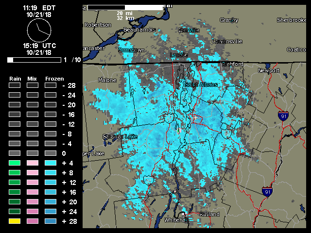
A weather radar image from midday on Sunday showing the continuous push of moisture from the northwest hitting the Northern Green Mountains and giving us continuous light snowfall.

After a simply gorgeous fall day on Saturday, Sunday kicked off cold and blustery, and once the snow showers got started in the morning, they literally kept going all day with that classic upslope flow from the northwest.  There were still a few flakes coming down, even around midnight last night.

We had numerous rounds of transient snow accumulations during the day, and it stuck around better after dark when the temperatures had dropped a bit, but there was still nothing around as of this morning.  I recorded one of the early 0.1” accumulations, and then a 0.2” accumulation later in the day after one of the heavier bouts of snowfall, but what I found in the rain gauge this morning was a bit under 0.01” so liquid goes down as a trace.

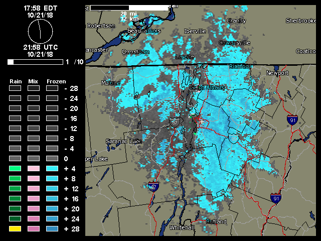
“…once the snow showers got started in the morning, they literally kept going all day with that classic upslope flow from the northwest..”

This event was the second accumulating one at our house this month, and the fourth one for the mountains.  Looking ahead, there seems to be some potential for snow in the midweek timeframe, and then again out toward the weekend.

Additional rounds of snow for Vermont

Since mid-month, our weather pattern has shifted to a more seasonable, and even below average one with respect to temperatures here in Vermont.  After our first mountain snows of the season over the weekend, there was a touch of snow Tuesday night in the upper elevations to put down the second coating of the season.

This season’s most notable snowfall so far affected the area from Wednesday into Thursday.  Colleagues of mine at UVM reported seeing frozen precipitation for a time around midday Wednesday, and as the afternoon wore on, snow levels began to drop more consistently.  Snow levels were approaching the bottoms of the mountain valleys as evening approached, and by 7:00 P.M. we were starting to get accumulation at our house.  By Thursday morning we’d picked up 1.2 inches of snow to mark the first accumulation of the season at our house.

Killington opened for skiing today, and there are still additional chances for snow in the forecast over the next week, so we’ll be on the lookout for whatever wintry weather Mother Nature might bring our way next.


Average date of first snowfall for Mt. Mansfield in Vermont

Having recently picked up our first snowfall of the season here in Vermont, reports and discussion in the New England Regional Forum at American Weather had people wondering where this event sat with respect to the average date of occurrence for the first snowfall on Mt. Mansfield.  I’d been curious about that date as well, so I used the data from the Mt. Mansfield co-op weather observations site, which comes from the ridgeline of the mountain up near the 4,000-foot elevation.  It’s a fairly substantial data set that goes all the way back to 1954, and Wesley Wright set it up to be available through the SkiVT-L site at UVM.

“The data suggest that our first snow of the 2018-2019 winter season from this past Saturday (October 13th) is a few days on the late side of the mean for first accumulating snow (October 10th), but overall quite typical.”

There are a couple of seasons that I couldn’t include in the statistical analysis because of gaps in the data collection early in the co-op site’s history, but there were still 62 seasons in the data set that provided useful information.  The data suggest that our first snow of the 2018-2019 winter season from this past Saturday (October 13th) is a few days on the late side of the mean for first accumulating snow (October 10th), but overall quite typical.  The full results from the statistical analysis are below, so have a look and think snow!

Date of 1st Accumulating Snow at Mt. Mansfield, VT Co-Op Station:

Mean:  10/10
Median:  10/8
Mode:  10/17
S.D.:  15 days
n:  62
Earliest:  8/28/1986
Latest:  11/17/1985

First snows of the 2018-2019 winter season in the Green Mountains of Vermont

An image showing Camel's Hump in Vermont with the first snows of the 2018-2019 winter season in the Green Mountains
Camel’s Hump showing signs of the first snow of the season for the Green Mountain of Vermont

While the first half of October was fairly warm, the weather models have been suggesting a shift to more seasonal temperatures as we hit mid-month.  The potential for some mountain snow was in the forecast last night, and indeed as of yesterday afternoon snow was already being reported at Whiteface Mountain across the lake with video of the flakes.  Here on our side of the lake, we heard from Powderfreak early this morning that snow had been sighted in the mountains around Stowe, and he was heading up for some investigation.  An hour or two later, he had send along pictures, and indicated that accumulations on Mt. Mansfield were about a half inch and started at an elevation of roughly 2,300 feet.

“…it looks like we’ll have more opportunities for snow this week with accumulations potentially even down to the mountain valleys.”

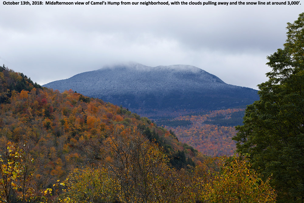
Here at our house, I did a morning check to find that the cloud ceiling was still only about 2,000 feet and there were no obvious signs of snow below that level.  I gave the clouds some time to think about clearing a bit, and then headed out in the neighborhood during the mid-afternoon period to see what snow might be visible.  Indeed the cloud ceiling had risen by about another 2,000’ and I was able to catch Camel’s Hump as the clouds had just about broken away.  The snow line at that point looked to be around 3,000’.

The first snows of the 2018-2019 winter season are in the books here in the Greens, and the National Weather Service Office in Burlington says it looks like we’ll have more opportunities for snow this week with accumulations potentially even down to the mountain valleys.  We’ll see what transpires as even colder air moves in, so stayed tuned for more October snow updates!

One last bout of snow for October

A radar image showing snow falling in the Adirondacks and in the Green Mountains of Vermont on Halloween
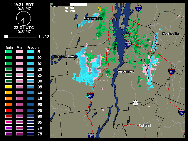
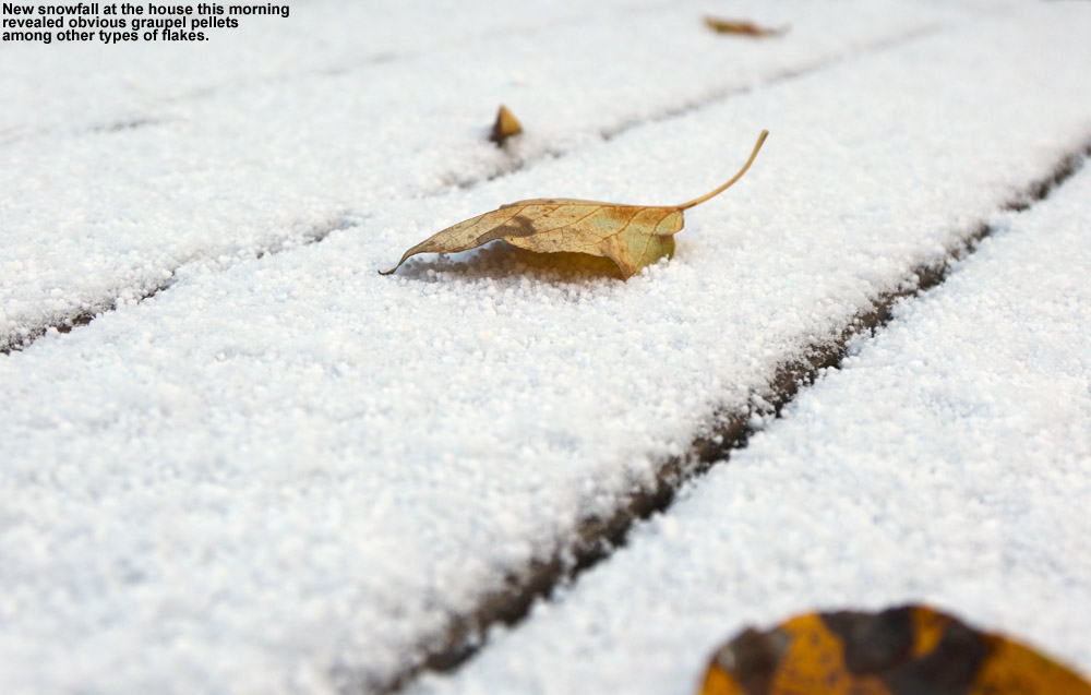
Radar image on Halloween night snowing snow in the Adirondacks and along the spine of the Green Mountains that prompted me to check on the type of precipitation we were receiving at the house.

After our big autumn storm that brought substantial wind and power outages to Vermont (including our house), cold air came into the area today and brought one last snowfall for the month on Halloween.  Powderfreak is out of town, but his colleagues at Stowe kept him apprised of what was going on at the mountain with pictures of the fresh snow.

As is typical for this type of weather setup with a flow from the Great Lakes, the areas around the mountains often get the most vigorous precipitation, which can lower snow levels down to the valleys.  I wasn’t home during the day to see if anything frozen fell at our house, but I wouldn’t be surprised if we got something.

There was additional precipitation while we were out in town for Trick-or Treating with the boys, with fairly heavy rain at times, and when we got home I saw that the moisture was still pushing into the mountains.  With the temperatures dropping into the 30s F I went out to check the precipitation during one of the heavier bursts, and sure enough, there were some partially frozen aggregates coming down, which confirms a trace of snow for today’s records. 

It’s interesting to note that if we hadn’t picked up any frozen today that would have been the first time in the 12 years we’ve been at this location that we didn’t get any frozen precipitation in October.  So that streak continues for now, but it’s still 12 days later than the mean, and of course it’s the latest “first frozen precipitation” we’ve seen here.  I guess with as warm as this October was, it’s nice to even get anything frozen, and at least the snowfall season is officially underway here.

Now it’s on to November, with more substantial chances for snow growing by the day.

Next October snow as we approach Halloween

An image of Mt. Mansfield in Vermont with some October snow as viewed from the University of Vermont in Burlington
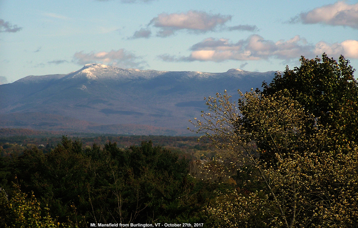
Mt. Mansfield and its latest coating of snow seen from Burlington

We’ve had plenty of pleasantly benign weather days this month, but yesterday was one of those raw October days that really speak to the seasonal progression.  Temperatures in the valleys even stayed well down in the 40s F, and a storm passing through the area brought bouts of heavy rain that made walking around outside a rather rough experience.  I wasn’t sure if this storm was actually cold enough to bring in some snow to the area, but sure enough, Powderfreak was already posting snowy images from Mansfield this morning and letting us know that the snow level was down to 3,000 feet.  Once the clouds began to break away from the mountains in the afternoon I was able to snap an image from my office of the new white near the peak of Mansfield behind some of the colorful foliage still hanging on in the Champlain Valley.  We’ve got a potent storm coming into the area Sunday that is expected to bring a lot of wind and rain, and next week there’s the chance for a bit more snow in the area as we get some cooler temperature and a flow that could bring moisture over from the Great Lakes.

First October snow for the Green Mountains of Vermont

An image of Mt. Mansfield in Vermont with a bit of October snow atop the Chin
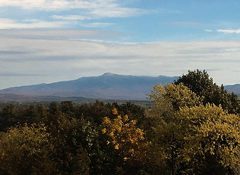
Today you can still see a bit of snow atop Mt. Mansfield above 3,500′ or so.

It hasn’t been an especially cool fall thus far in Vermont, and in fact we had some rather warm days with temperatures up to 90 degrees F for the Champlain Valley last month.  It’s hard to think of potential snow with temperatures like that!  Due to the heat, we actually delayed our September apple picking trip to Boyer’s Orchard with the Bennetts and the Burseys for one week to wait for a more autumnal feel.  The temperatures and generally fair weather have certainly made for some fantastic outdoor activities, but the warmth may have altered the timeline for the development of the fall foliage color.  In any event, by the beginning of last week I could already see that we were past peak color in the Winooski Valley.  Bare trees were numerous throughout the hillsides, leaving at least small gaps in the colorful views.

It’s funny, but despite the warm weather in recent weeks, we actually had some September snowfall on Mt. Mansfield and other peaks in the region.  We don’t get September snow every year, so it’s quite interesting that things came together to put some white on the peaks so early during a warm period.

With the fall foliage around and especially with the colors now beginning to wind down, more snow usually isn’t far behind, and indeed today’s dramatic drop in temperatures from the 70s F we had just yesterday evening made it really feel like we were transitioning further into fall.  We never got out of the 40s F in the valleys, so there was definitely a bit of a bite out there with wind on top of those temperatures.  While heading to a class today here on the UVM campus, it absolutely felt like one of those days where it could easily be snowing along the spine.  And, lo and behold, when I later checked in on the Northern New England fall thread on the American Weather Forums, Powderfreak was already reporting accumulating snow down to 2,700’ on Mt. Mansfield.  He posted some additional pictures later, showing how the snow had a hard time accumulating on the warm ground in most areas and was typically found on the trees.  He did report snowfall down as low as 1,500’ in elevation though, probably via help from the orographics of the Green Mountain Spine.  The Bolton Valley Facebook page also posted an image of flakes getting down to the Village, and I’m sure many of the local mountains saw flakes as well.

I hear Killington also took advantage of the cooler temperatures to test the snow guns, so we’re certainly on our way.  The longer range forecasts suggest a possible stretch of colder weather near the end of the month into November, so we’ll see what potential that brings with regard to manmade or natural snow.

Bolton Valley, VT 28OCT2016

An image of October snowfall in the Bolton Valley Village in Vermont
An image of ski tracks in powder snow on the Lower Turnpike trail at Bolton Valley Resort in Vermont
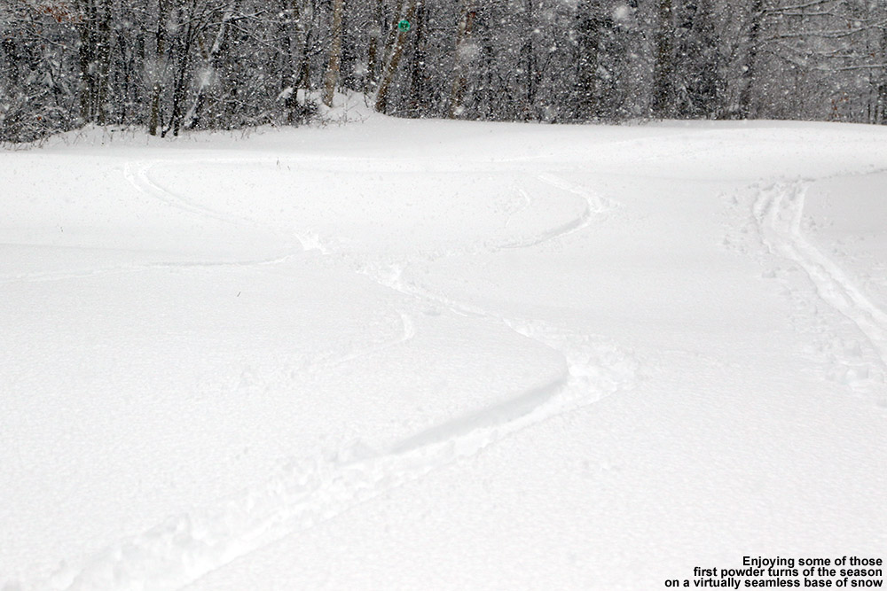
Taking advantage of our recent plentiful snows to get in my first turns of the season

We’ve had an impressive run of October snow over the past week in Vermont’s Green Mountains.  It started off with the big synoptic storm last weekend that dropped a foot or so of dense snow in the in the higher elevations.  After the system passed, we sat in the leftover cyclonic flow centered off toward the Canadian Maritimes for a few days, and that brought additional rounds of accumulating upslope snow.  And most recently, we had another large storm that started up yesterday.  It hit hard overnight and continued into today, delivering another 6 to 8 inches of hefty snow.  For local ski areas that have been keeping track of the accumulations, here’s what I’ve seen reported for totals this past week:

Stowe: 20”
Bolton Valley: 19”
Sugarbush: 19”
Killington: 17.5”

The snow that’s fallen is by no means just fluff – it’s really hefty stuff with a lot of water in it.  Thus there hasn’t been a lot of settling, and the snow has really put down quite a base.  Indeed, the ski resorts know what a substantial contribution this snow can represent to the start of their base building – Killington opened up for lift-served skiing starting on Tuesday, and even Stowe has started making snow, which they would never do in October if they didn’t think they’d be able to hold onto a good amount of it heading into November.

“…I was really psyched with how the turns felt – they were actually some of the easiest first turns of the season that I can recall in a long time, so I guess my legs are ready.”

I wasn’t able to get out for the last big storm on Sunday, but I had a bit of time this morning and had a chance to head up to Bolton Valley to check out what had transpired in the higher elevations and catch a few turns.  The bulk of the snow fell last night while it was dark, so I really only knew what was going on at our place down at 500’ in the Winooski Valley.  It was snowing for much of the evening, although it only accumulated to 0.2” due to the marginal temperatures in the 34 to 35 F range.  When I checked on the weather this morning, it appeared as though the snow level had crept upward a bit because our precipitation at the house was a mix of mostly rain with just a bit of snow.  That had me a little concerned about just how high the snow level had climbed, but so much liquid had fallen by that point (0.79” in our gauge) that there had to be a lot of snow up high.

An image showing heavy October snowfall at Bolton Valley Ski Resort in Vermont
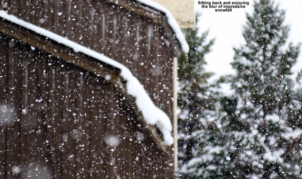
Arriving in the Village to heavy snowfall

I assembled my ski gear for a tour, paying special attention to not miss any of those items that one can often forget on that first outing of the season, and headed up to Bolton.  On the way up the Bolton Valley Access Road I saw the first signs of what I think was vestigial snow from last night’s lower snow levels at around 1,000’.  Snow quickly began to appear more frequently above that point, and it was around 1,400’ when the precipitation changed over to all snow.  Up in the Village lots at 2,000’ it was dumping big, fat flakes up to 2” in diameter.  It was hard to get a handle on how much snow fell from this most recent event since it was on top of previous rounds of snow, but depending on when the last plowing happened, I was finding 4” new in the 2,000’ elevation lot.  The mountain was reporting 6-8”, which didn’t surprise me at all for the higher elevations.

“It was a great ascent, temperatures were right around the freezing mark, there was no wind, and those huge flakes just kept pouring down.”

I headed up the usual Lower Turnpike ascent route, and was happy to find that there was a skin track in place from a couple of earlier skiers.  It was a great ascent, temperatures were right around the freezing mark, there was no wind, and those huge flakes just kept pouring down.  I only had enough time to make it up to the intersection with the Wilderness Lift Line at ~2,500’, but I’d pressed a quick pace and got a decent workout nonetheless.  When I began my descent I was really psyched with how the turns felt – they were actually some of the easiest first turns of the season that I can recall in a long time, so I guess my legs are ready.  And, as I noted earlier, this snow is most certainly not fluff – it’s dense with lots of liquid in it.  There was no concern about hitting the ground on turns, and there’s actually hardly any brush even showing on the trails.  The skiing was great; they certainly weren’t the highest “quality” October turns I’ve had with respect to snow consistency, but the snow certainly wasn’t sopping wet. I was happy to be on my115 mm fats to keep myself from getting bogged down in that dense stuff though.  I’d recommend going fairly fat for anyone that is heading up for some turns in this snow.  The snow though dense, actually delivered some nice powder turns.

An image snowing the total snow depth on October 28th at an elevation of 2,500' at Bolton Valley Ski Resort in Vermont
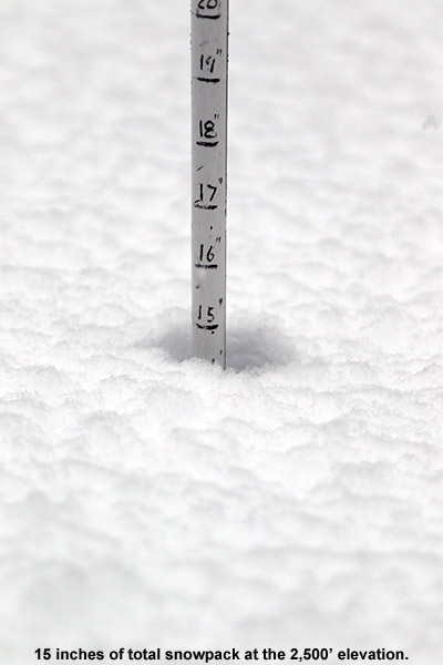
During my tour I checked total snow depth frequently, and I’d say it was something in the range of 8-12” at 2,000’, and a solid 15” at 2,500’.  I’m not sure how much more it increased above that point, but 15” at 2,500’ is obviously great for October.  All I can say is “wow” with regard to the coverage on those trails though.  It’s been an impressive series of storms up high, and I can’t wait until we can get into some more winter storm cycles, which at this point appears like it will be a week or two away in November.  Whatever the case, it would be nice to get at least a bit of a break from storms to take care of the lawn and everything else around the house that needs to be prepped for winter.

First storm of the winter season in the Greens

An image from the Burlington National Weather Service showing projected snow accumulations for our first October snowstorm of the season
The projected accumulations of roughly a foot of snow in the higher elevations of the Green Mountains came to fruition today.

We’ve had several days to watch the forecasts building up to a potential first snowfall of the 2016-2017 winter season for the Green Mountains of Vermont.  The storm was projected to move along the coast and up into the Canadian Maritimes, which, as usual, would put it at the point where cold, moist air could wrap around and hit the spine of the Greens from the northwest.  Yesterday afternoon the snow levels began to drop toward the summits, and as daylight began to fade we were able to see that snow was starting to accumulate up near 4,000’ via the new Lincoln Peak Snow Cam.  At around 10:30 P.M. I looked outside and saw that snow had made it all the way down to our house at just 500’ in the Winooski Valley, which meant that the mountains were well into the snow.  We’d accumulated a couple of tenths of an inch of snow at the house before I headed off to bed.

As of this morning we’d picked up about a half inch of snow down at the house, and accumulations reports began to come in from around the area.  One of the more surprising results the storm was just how much snow had accumulated at relatively low elevations on the western slopes of the GreensThere were reports of up to 6 inches of dense snow in areas that still had substantial leaves on their trees, and combined with some aggressive winds that meant downed trees, travel difficulties, and some power outages.

In the higher elevations, Powderfreak reported finding 5.5 inches at 1,500’ the base of Stowe Mountain Resort, a foot at 2,000’ – 2,500’, and accumulations seemed to generally top out in that range up and down the Central and Northern Green MountainsBolton Valley reporting 9 inches, 11 inches were found at the Mount Mansfield Stake, and there were images of waist-deep drifts at Jay Peak.  I didn’t get a chance to get out on the slopes because we were down at a New England Revolution match at Gillette Stadium, but it looked like the dense snow did a decent job of covering up surfaces to enable some fun October turns.  The weather looks relatively cool this week, so the snow shouldn’t be going anywhere immediately, and I heard Killington even plans to open on Tuesday to start the lift-served ski season.

First Waterbury snow of the season

An image of snow and leaves from an October snowfall in Waterbury, Vermont
Some of today’s snow at the house in Waterbury, with a little foliage thrown in

While the Green Mountains had already been whitened at the very beginning of the month, this weekend has featured the first skiers hitting the slopes, and the first notable snow accumulations in the valleys. Here at our house in Waterbury we’ve picked up nearly two inches of snow between the various rounds of flakes over the past couple of days, and with intermittent clouds and sun at times, people have been out getting some great pictures of snow and foliage. Here’s to what is hopefully the first of many great snowfalls to come this season!