It’s that time of year again when we start to think more about the colder weather, and for the past few days our NWS point forecast for Waterbury has shown sub-freezing low temperatures at the end of the week. Talk about the first snowfall of the upcoming season, has already begun – over in the New England forum at Americanwx.com, Dryslot pointed out the potential snow showers and frost in the forecast from the National Weather Service office in Portland, Maine. This morning I saw that there is a cold weather update at the Famous Internet Skiers website, and on SkiVT-L, there was a visit from Roger Hill, who threw out the potential for a little snow accumulation at Jay Peak. Although it doesn’t seem to be the case this time, I’m certainly reminded of a couple of seasons ago when some September snowfall actually produced enough snow to get in some skiing. The past couple of days have been pleasantly summery, even up here in Northern Vermont, but it sounds like the crisp feel of autumn is on our doorstep.
2010-2011 Ski Season Summary
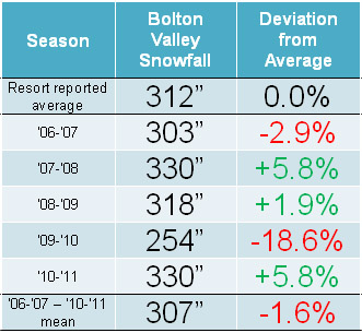
Having now compiled all our ski trip and winter storm summary reports for the ’10-’11 ski season, I’ve put together this season summary as a view of how things transpired from a Northern Vermont local perspective. It’s interesting to note that for Burlington, winter ’10-‘11 was well above average for snowfall (128.4”, 175%), while out in the mountains at our house the deviation was much less (197”, 114%), and indeed in the higher elevations of the Northern Greens like Bolton it was even closer to average (330”, 106%), so ski resort snowfall around here was essentially average. I actually made a chart for a post at Americanwx.com concerning the ’07-’08 season, which used Bolton’s snowfall from the past several seasons as a general indicator of how the snowfall has been in Northern Vermont:
One can see from the chart that ’10-‘11 was basically average for snowfall, and that the amount of snow (330”) was identical to ’07-’08. I would add that the general impression was that consistency of winter temperatures was a bit better than average in ’10-‘11 due to fewer warm events, so the quality of snow surfaces was higher. I’m not sure how much better than average it was though, since it seems that during midwinter, the norm in the higher elevations of the Northern Greens is to have about one warm episode per month. Also, since we were essentially out of the main track of synoptic storms until February, there wasn’t much in the way of moderate-density snowfall to resurface the slopes. I try to address the consistency of temperatures/quality of the snow surfaces in the text below though, at least in the context of weekends; I should note that it’s possible there could have been some midweek weather issues that simply flew under the radar for me. For the quality assessment I simply focused on whether or not we were skiing powder, because unless there is some sort of notable rise in temperatures, there is always powder available.
A monthly breakdown of snowfall and my perspective on the season follows below – you can click on each month (except November) and it should bring up that month’s posts in the J&E Productions Web Log. I only have the monthly snowfall for my house and not the ski areas, but the percentages relative to average often parallel the mountains reasonably well, especially for Bolton which is right up above us:
October: Pretty typical in that we got at least some snow for skiing; we had 1.0” of snow at the house. October snowfall in the lower valleys is often minimal enough that the percentages aren’t all that relevant, but that number is 111% vs. the five year average since we’ve been at our house, so indeed that’s rather “normal”.
November: Very poor; we got just 2.4” of snow at the house (29% of average) and I don’t really remember it, nor do I have any entries for that month in my ski log, so that says plenty right there. I do have a vague recollection of storm after storm tracking to our north and west giving us mostly rain though, so that would explain the low snowfall total. The lack of snowfall wasn’t necessarily a huge concern at the time since it was “only November”, but without good November snowfall, getting to appropriate base depths and excellent skiing in December can be that much harder.
December: Quite normal, 46.0” of snow at the house (right about average at 102%). Fortunately, even with minimal November snow we were skiing natural snow terrain by December 10th up at Bolton; the holiday period featured some decent skiing, with 7 outings for me during that stretch, indicating that the snow was obviously OK. Bolton had picked up 4 feet of snow from the storm at the beginning of the month, however, a lot of that snow, as well as what fell later in the month, was upslope fluff. So, even if one assumes a fairly average amount of snowfall for the mountains like we saw in the valley, the very dry nature of the snow meant that there was less liquid than usual, resulting in base depths that really didn’t build quickly. The Boxing Day Storm was unfortunately the start of a pattern that would last the next five to six weeks, with the big synoptic storms staying well south of the region and pounding Southern New England, while northern areas remained on the fringe and essentially survived on fluff. Temperature consistency/snow surface quality: Skiing was done on all 4 weekends of the month, and out of the 12 outings in my records, the only outing without powder skiing was Friday, Dec 31st, so that suggests pretty consistent temperatures.
January: We got 55.5” of snow at the house, which is above average (137%) in what can sometimes be a dry, midwinter month. However, January was essentially a month-long continuation of the trend that started on Boxing Day, and we were living on mostly Northern Vermont Champlain Powder™ fluff. We had a couple of good upslope storms in the early to mid part of the month (January 7th and January 12th) that made for some fine skiing, but obviously since so much of it was pixie dust, the base depths just could not build the way that they would with some synoptic storms. Temperature consistency/snow surface quality: Skiing was done on all 5 weekends of the month, and out of 11 outings in my records, the only outing without powder skiing was Saturday, Jan 1st due to the warmth at the end of December. So I think one could argue that weekend ski surface consistency through Dec/Jan was better than average with only one (instead of two) weekend-affecting warm up(s) for the two months.
February: This is when the storm track finally shifted north and we got some notable synoptic storms; the first one was right on the 1st, and then we had a second storm on the 5th. That first storm brought just over a foot of snow for us down in the valley, and was by far the largest for the month. Thus there weren’t really any mega dumps based on my records from the house, but there was plenty of the usual good skiing at Bolton and even good skiing at Stowe. Snowfall was 48.1”, which is roughly average at 108%. Temperature consistency/snow surface quality: Out of the 10 outings in my records, all 10 of them had powder skiing, so February was perfect in that regard. However, while skiing was done on all 4 weekends of the month, we had to wait until Monday of the long weekend to ski because there had been some sort of warm-up. So I’d say the month was pretty typical with at least that one warm-up.
March: We continued to stay in the storm track for most of March, with our biggest valley snowfall of the season (25.0”) coming from the March 5th storm. We did wind up with notably above average snowfall in the valley for the month (39.6”; 155%), essentially due to that one big storm and aided by the fact that what I’ve got for a March average could be a bit low due to very poor Marches in ’09 (12.6”) and ’10 (2.1”). Temperature consistency/snow surface quality: Skiing was done on all 4 weekends of the month, and powder skiing was done on all those weekends, however, there was also notable infiltration of non-powder skiing days into the weekends. Relative to the previous three months, only 9 of our 12 outings for March featured powder skiing, so while still a pretty good ratio, it was certainly a decrease. Indeed there were multiple warm ups in the month because those three non-powder days were actually on three different weekends (the 1st, 3rd, and 4th weekends). Fortunately, those weekends were somewhat redeemed by powder on the other day. By March, especially toward the end, things may start to fall off a bit from the typical rate of one warm episode per month, but I would expect that with at least 3 individual warm ups in March, it was nothing great or even above average in terms of consistency.
April: This was again quite a poor month in terms of snowfall and powder skiing; although snowfall correlation between our location down at the house and the mountains can really start to wane as one moves through April and snowfall becomes more and more elevation dependent. Snowfall at the house was well below average for the month (4.4”; 61%). We did at least start out the month with a snowstorm on the 1st and another one on the 4th; these events produced some good weekend powder skiing at Bolton and helped the mountain snowpack to surpass 100 inches at the Mt. Mansfield Stake. However, the snowfall really fell off after that. Temperature consistency/snow surface quality: Skiing was done on all 5 weekends of the month, but only 3 out of 9 days had powder and only 2 of the weekends had powder skiing. People were excited because we had a relatively deep snowpack during the month and coverage stayed longer than normal, but after that first week the storm track had shifted to the north/west and it was just storm after storm that featured warmth and little to no snow, even for the mountains. I commented on that trend in a post at Americanwx.com, since there can easily be feet of snow in the higher elevations in April, and instead of just some corn days or spring crud, we could have been skiing some great powder.
May: The May skiing was good due to the healthy snowpack, and I did get out in the powder on the 6th for top to bottom skiing on Mansfield. We didn’t get any snowfall at the house during the month, but May’s average snowfall numbers down at our elevation are pretty minimal like October, and with the high sun angle and warming as we approach the solstice I suspect even more removed from correlation with what the mountains see. Temperature consistency/snow surface quality: I wouldn’t say May powder is consistent enough to worry about. I only got out for two days during the month, but at least one was a powder day; the other day was a corn snow day at Bolton so that was also good even if there wasn’t fresh snow.
June: Our only day in June was outside VT on the East Snowfields on Mt. Washington, and the snowfield was probably smaller than usual for that time of year due to the below average Mt. Washington snowfall for the season. There actually had been some frozen precipitation in the northern mountains leading up to that day, but we were skiing corn snow.
So in terms of overall snowfall, the two above average months of January and March were basically counteracted by the two below average months of November and April, and with the rest of the months being about average, the snowfall for the season ends up… about average. Some plusses were better than average snowpack in April and May, but that’s somewhat counteracted by the lower than average snowpack in November, December, and January. It looks like there was an uptick in consistency in the December-January period due to just that one notable warm-up, but with February and March coming in probably about average in that category, and while November is not especially consistent in terms of temperatures, even in the higher elevations, it must have been below average to get so little snow for the month. So taking the trends of consistency as an aggregate from November through April, I wouldn’t say that there was a massive improvement in temperature consistency/snow quality for this area. Something that I have noticed around here is that having a few more storms with mixed precipitation is not necessarily a huge detractor in terms of snow quality. The ’07-’08 season was a good example of this. We were right in the storm track, so if we did receive some mixed precipitation, there was often another storm on its heels so quickly, that old snow surfaces were covered up. It felt like we were right in the storm track for most of that winter, except that we had a relatively poor April with little snowfall (we picked up just 1.6” of snow at the house, even less than this past April). It is interesting to note that winter ’07-’08 (consistently stormy from November through March) and winter ’10-’11 (biggest synoptic storms focused on just February and March) provide quite disparate examples of how to get to very similar seasonal snowfall totals (203.2” and 197.0” respectively at the house, and 330” and 330” respectively up on the mountain).
Tree skiing: While working on some web page material, I came across the post I made about the average date for the start of Northern Vermont tree skiing, so I decided to add in the ’10-’11 data and see how the season compared. In my initial analysis through the ’09-’10 season, the average start date for tree skiing was December 9th ± 13 days with an average of 28.2 ± 6.8 inches of snowpack at the Mt. Mansfield Stake. In terms of my personal log of outings from last season, I’ve got a start date of December 18th, 2010 for tree skiing, and the addition of these data alters the averages very slightly, bringing the date one day later to December 10th ± 13 days, and the average snowpack down a tenth of an inch to 28.1 ± 6.5 inches. So in terms of the ’10-’11 season, the start to tree skiing was slightly late in that it started about a week later than the mean date I’ve calculated. With the horrible November in terms of snowfall, and much of the December snowfall being dry fluff, the late start is not too surprising. However, the date is well within one standard deviation, so in that sense the start to tree skiing was another parameter of the season that was basically “average”.
On that temperature consistency/snow quality note, I was curious about the powder skiing we did throughout the season, so I checked my reports. For the list of outings below, I placed a P whenever we were skiing powder, and put a red X if we weren’t, so it shows the pattern of when we did have powder, and when we did not. Links to the text and pictures for all the individual reports are available below if people want more details about the depth/consistency of the snow, or one can also step through the J&E Productions web log, which has an entry for each outing. It’s interesting to note that starting at the beginning of the season in October and continuing through to March 26th, there were only four days (December 31st at Bolton Valley, January 1st on the Bolton Valley Nordic/Backcountry Network, March 5th at Cochran’s, and March 20th at Stowe) where we weren’t skiing powder. Strangely enough, I’ve never looked at a season in that way before, but it did give me an even greater appreciation for just how much powder there is to ski around here. After March 26th, the powder skiing really trickled off this season, although there were still at least a few days in there. I’m not sure how this season compares to others since I’ve never looked at one like this before, but I suspect most other “average” seasons would look similar for the way we ski, and with our pattern of skiing there might be similar patterns even in seasons that deviate more from average snowfall.
P Stowe, VT, Saturday 16OCT10
P Stowe, VT, Sunday 05DEC10
P Bolton Valley, VT, Friday 10DEC10
P Bolton Valley, VT, Saturday 11DEC10
P Stowe, VT, Sunday 12DEC10
P Bolton Valley, VT, Saturday 18DEC10
P Bolton Valley, VT, Sunday 19DEC10
P Bolton Valley, VT, Thursday 23DEC10
P Bolton Valley, VT, Friday 24DEC10
P Bolton Valley, VT, Monday 27DEC10
P Bolton Valley, VT, Tuesday 28DEC10
P Bolton Valley, VT, Thursday 30DEC10
X Bolton Valley, VT, Friday 31DEC10
X Bolton Valley Nordic & Backcountry, VT, Saturday 01JAN11
P Bolton Valley, VT, Saturday 08JAN11
P Bolton Valley Nordic & Backcountry, VT, Saturday 08JAN11
P Stowe, VT, Sunday 09JAN11
P Bolton Valley, VT, Thursday 13JAN11
P Bolton Valley, VT, Saturday 15JAN11
P Bolton Valley, VT, Sunday 16JAN11
P Bolton Valley Nordic & Backcountry, VT, Monday 17JAN11
P Bolton Valley Nordic & Backcountry, VT, Saturday 22JAN11
P Bolton Valley, VT, Saturday 29JAN11
P Stowe, VT, Sunday 30JAN11
P Bolton Valley, VT, Thursday 03FEB11
P Bolton Valley, VT, Saturday 05FEB11
P Stowe, VT, Sunday 06FEB11
P Bolton Valley, VT, Saturday 12FEB11
P Stowe, VT, Sunday 13FEB11
P Bolton Valley Nordic & Backcountry, VT, Monday 21FEB11
P Bolton Valley, VT, Friday 25FEB11
P Bolton Valley (Timberline), VT, Saturday 26FEB11
P Bolton Valley, VT, Saturday 26FEB11
P Stowe, VT, Sunday 27FEB11
X Cochran’s, VT, Saturday 05MAR11
P Bolton Valley, VT, Sunday 06MAR11
P Bolton Valley, VT, Monday 07MAR11
P Stowe, VT, Tuesday 08MAR11
P Bolton Valley, VT, Saturday 12MAR11
P Stowe, VT, Sunday 13MAR11
P Monroe’s Sugarin’, Barton, VT, Saturday 19MAR11
X Stowe, VT, Sunday 20MAR11
P Bolton Valley, VT, Wednesday 23MAR11
P Bolton Valley, VT, Friday 25MAR11
P Bolton Valley, VT, Saturday 26MAR11
X Stowe, VT, Sunday 27MAR11
P Bolton Valley, VT, Saturday 02APR11
X Stowe, VT, Sunday 03APR11
P Bolton Valley, VT, Thursday 07APR11
X Bolton Valley, VT, Saturday 09APR11
X Stowe, VT, Sunday 10APR11
X Bolton Valley, VT, Sunday 17APR11
X Stowe, VT, Tuesday 19APR11
X Sugarbush, VT, Friday 22APR11
P Bolton Valley, VT, Saturday 23APR11
X Bolton Valley, VT, Sunday 01MAY11
P Stowe, VT, Friday 06MAY11
X Mount Washington, NH, Saturday 04JUN11
So yeah, long story short, pretty average season in my book. On that note, since we’ve been back from Montana, the only season we’ve had with substantial snowfall deviation from average for Northern Vermont was a negative one in ’09-’10 as I show in that table of Bolton Valley snowfall near the top of the post. There definitely hasn’t been anything like what many parts of the Western U.S. saw last season, but as I look at the list of outings above there’s still been plenty of great skiing.
June upslope rain, with some snow for the mountains
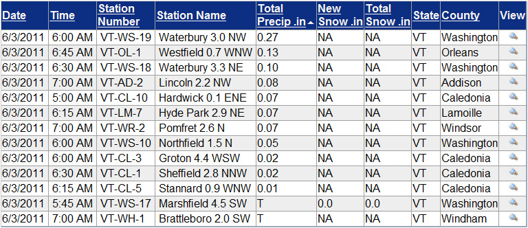
After drying out to amazing low humidity on Wednesday, temperatures got really cool on Thursday and we got into a classic Northern Vermont upslope flow. There was actually some snow falling in the highest elevations of the Greens, and certainly over in the Whites. There were just a few spits of rain in Burlington when I left yesterday afternoon, but of course I got to the house and it was a steady light rain with a tenth or two of an inch already in the gauge. This morning the gauge contained 0.27” of liquid in it and I thought, heck, that’s a half foot of upslope snow right there when the temperatures are appropriate. I was looking at the radar image posted by Powderfreak at Americanwx.com and could see how at one point it exploded with 35 db and even a few 40 db echoes over our area at the junction of I-89 and the Chittenden/Washington county line, and then dissipated on the east side of the mountains once it dropped its payload:
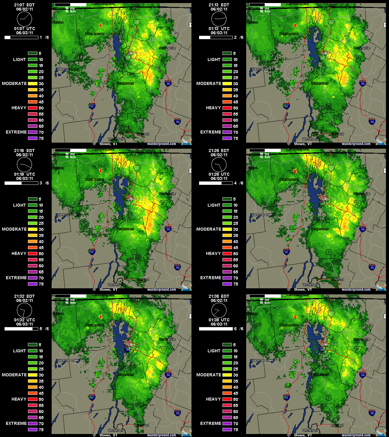
When I submitted my report to CoCoRaHS this morning, I took a quick look at what some of the other stations had reported. I sorted the list below from around 7:00 A.M. by total precipitation, but even without that, it was pretty easy to see the locations that got the liquid:
I haven’t been able to check out the local peaks to see if they have any white on them because they’ve been socked in, but Mt. Washington got some new snow and they must have been whitened. It’s 26 F up there now with freezing fog and 50+ MPH winds. With such a good-looking forecast for tomorrow, we may head over for some turns, but these past couple of days certainly should have been good for snow preservation.
Thunderstorms and some heavy rains overnight
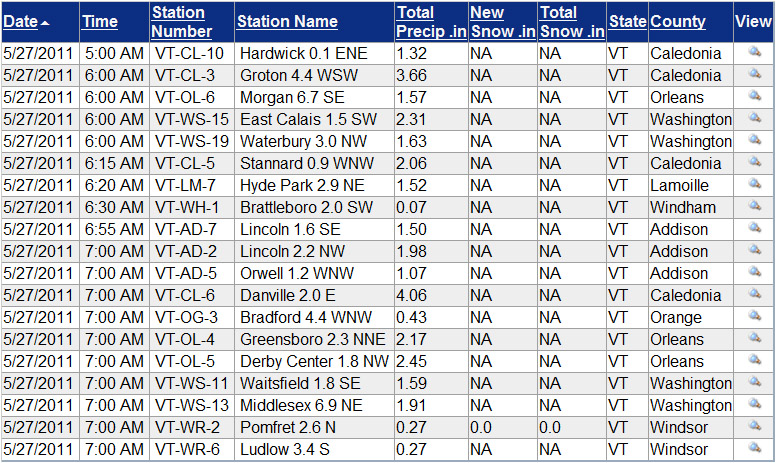
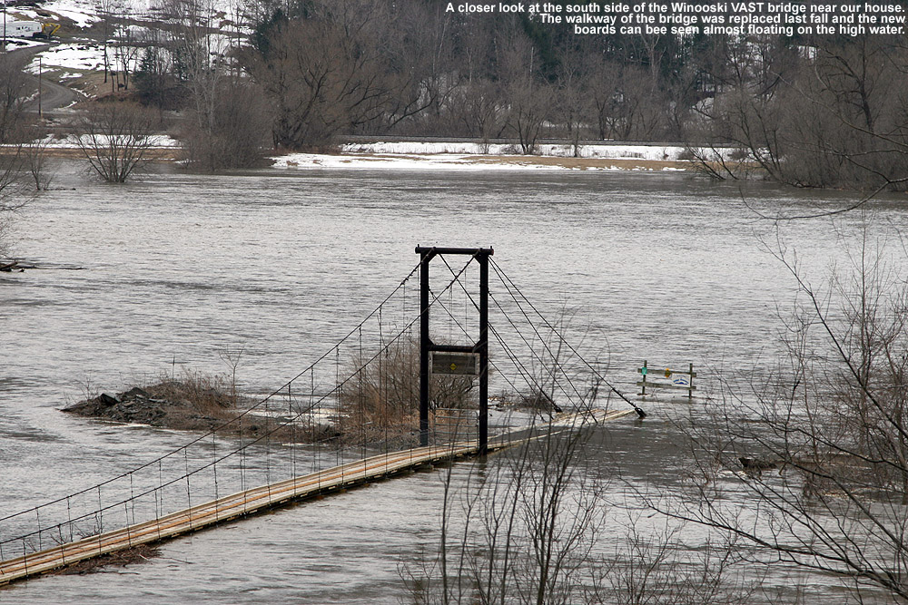
It didn’t seem like it rained a lot last night, but I found 1.63” in the gauge this morning, so it obviously added up. We had some losses of power similar to what Powderfreak noted – a couple short ones in the evening, and then it went back out again around 8:00 P.M. and it was gone for the night. It came back on early this morning at some point. I didn’t stay awake for it, but apparently we had thunder and lightning pretty continuously through about 2:00 A.M. This morning I was surprised to see the Winooski way back up to a level even with our local V.A.S.T. bridge and hogging almost the entire valley in our area, just like back in mid April when the snowpack was starting to melt. I think it may have even been a bit higher this time, as the typically flooded residences and farmland west of the Cider House seemed quite inundated with water. The water was probably the closest I’ve seen it to washing over Route 2 in that area – I think another foot of depth and there would have been water on the road. I was surprised it got so high relative to the amount of water I recorded in the gauge, but then I checked the CoCoRaHS maps and saw that one observer over in Caledonia County reported 3.66” of water with this event. I don’t think they are actually in our drainage, but clearly someone out to our east got a load of water from these storms overnight. Our bus was late this morning due to road closures in the Montpelier area, so things have certainly been disrupted by the water. I added an image of the VT CoCoRaHS table of Daily Precipitations Reports as of ~7:30 A.M. this morning, and it indicates that someone over in Danville got over 4 inches of liquid from these storms, so there are reports of some large amounts of liquid coming in from Caledonia County.
Snow line around 1,500′ this morning
It was ~41 F at the house this morning, so I suspected that the snow level was still a bit high for new powder in the easily accessible elevations, but I checked in at Bolton on the way in to Burlington this morning to get a handle on where things were at in terms of base and new snow. I could tell that it wasn’t yet a huge hit below 2,500’ yet because the cars coming down the road didn’t have snow on them, but the precipitation certainly looked like snow up high. Here’s the vertical temperature profile I observed on the Bolton Valley access road around 7:00 A.M. with comments on the precipitation/accumulation; hopefully it will be useful for other mountain recreationalists:
340’: 41F (light rain)
950’: 40F (light/moderate rain)
1,100’: 39F (moderate rain)
1,500’: 38F (moderate rain/snow)
1,800’: 37F (moderate snow)
2,000’: 36F (moderate snow)
2,100’: 35F (moderate snow, accumulating)
As you can see from the above list, snow wasn’t accumulating until I reached the village at 2,100’, but it seemed to be accumulating on most surfaces other than the pavement, and there was probably ¼ inch down when I was there. Skier’s left of Beech Seal showed a couple of breaks in coverage, as I suspected it would based on my Sunday observations, but it was still pretty close to continuous.
Even back down in the valley, there were some bouts of moderate precipitation, so hopefully that continues to hit the mountains. Roger Hill was thinking that the snow level would rise a bit during the day today, so that may have to be factored in as well.
Heavy rainfall and more high water today
I haven’t seen any snow with this system, but last night’s precipitation seems worthy of note because we had 2.30 inches of liquid and the Winooski is back up even with our local VAST bridge as it was on the 11th, despite the fact that most of the snow has already melted in the lower elevations. Some area schools are closed due to road access issues with this event. I just summed my CoCoRaHS numbers for April and with this latest event the total liquid is right at 8.00 inches for the month thus far. While I had that open I grabbed a few additional liquid numbers. For the 2011 calendar year up to this point at my reporting location the liquid precipitation is at 20.46 inches, for the 2010 calendar year the total was 54.17 inches, and for the ’10-’11 snowfall season as it currently stands (October 15th, 2010 – April 16th, 2011), the total was 28.09 inches.
The snow in the yard has melted
The last of the snow in the yard melted today, so I can finish off that portion of my seasonal snowfall numbers. The data for the last of the snow melting out in the yard (as of this season the mean date is April 15th ± 10 days) is actually something I’ve recorded all the way back since our first winter here (2006-2007) and April 24th is one day later than the previous record I had down (April 23rd, 2007). This puts the continuous snowpack season in the yard at 141 days, which is exactly the same number recorded for ’06-’07. Both of those seasons had slow starts with poor November snowfall, and snowpack that did not become established until early December, so they are well behind the highest value of 152 days recorded for the 2007-2008 season. The next benchmark I’ll monitor will be when the last of the snow melts out in our neighborhood, which tends to be about a week beyond when the snow melts out at the house.
As I was skiing at Bolton yesterday I was reminded of some outings in April ’07, and realized that while the snowpack is in excellent shape this spring, the skiing this month has really paled in comparison to the equivalent period back in ’07. Even down at this elevation we had almost two feet of snowfall in April ’07, and this season we’ve had just 4.4 inches. I’m not sure what the mountains have had this April, but in ’07 it was measured in feet; I skied one day mid month on the mountain where I found up to 19 inches of new snow, and that was for just one of the storms. The reading from the Mansfield stake on Friday was certainly respectable at 82 inches, but for the same date in ’07 it was actually at 84 inches. It’s really been just an issue of the storm track this April; the moisture has been there, but the track has been too far to the north/west to get into the appropriate combination of precipitation and temperature. With a good track over the past few weeks we probably would have had another April 2007 on our hands. I think that the past couple of springs have been so poor in the snowfall department that some perspective has been lost on April’s potential, this one is good in terms of base/snowpack, but I’d say subpar for snowfall (we’re still below average by a few inches at the house).
Snowpack has reached zero at the back yard stake
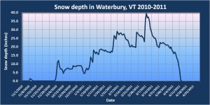
As of this morning, the depth of snow at our back yard stake has reached zero, so I’ve updated my Waterbury snowpack plot and included it in this post. This means that the last day with snow at the stake was 4/12, and the average I have for that value is 3/27 ± 14 days, so this season is a couple of weeks later than that average. The next benchmark I’ll monitor will be when the final snow in the yard is gone, and based on data I have from ’07-’10, that average date is 4/12 ± 10 days, so roughly a couple of weeks later than when the snow has melted out at the stake. As of today, the yard snowpack has been around for 130 days, but that is actually still below average (138 ± 14 days) because of the late start to the season; the start of continuous snowpack this season was on the later side at 12/5 vs. an average of 11/27 ± 9 days. Unless the rest of the snow in the yard melts unusually fast however, the end result of the snowpack season will probably be somewhere around that average value.
I’d say that winter temperatures were more consistent than usual this season, so it’s a little easier to see the steady climb in snowpack from a value of 0″ on 12/4 through the value of 39.5″ on 3/8. The average rate of increase during the period was 0.42″/day. This was a decent snowpack season, with snow depth days from my stake coming in at 2,227 depth-days vs. the average of 1,812 ± 741 depth-days. However, the combination of the rather late start and long stagnation through mid January (visible on the plot) while the storms were going south, meant that it certainly wasn’t up where the ’07-’08 season was at over 2,500 depth-days.
High water on the Winooski at the VAST snowmobile bridge
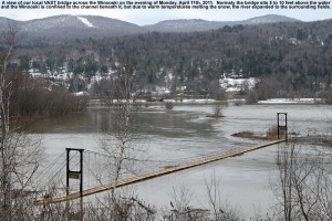
With the recent warm temperatures melting some of the snowpack, the Winooski was quite high today, so I’ve added a couple of pictures of our local VAST snowmobile bridge. The bridge was refurbished in the fall, and from the pictures one can see that the boards are still pretty light in color. Normally the bridge is 5 to 10 feet above the river, so that provides a sense of the rise of the water level due to the melting snow, and with the fields off to the south taken over by water (visible in the background) the Winooski was several times its normal width.
100 Inches
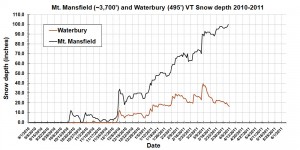
- The snowpack at the Mt. Mansfield stake hit 100 inches after yesterday’s snowfall – click for the full size plot
