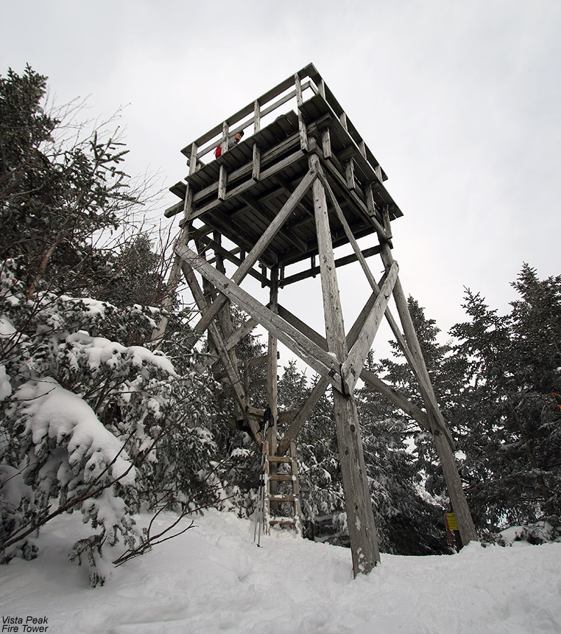
Visiting the Vista Peak fire tower to take in some of the views on today’s tour at Bolton Valley and the Woodward Mountain Trail
The snowpack is currently in great shape here in Green Mountains of Northern Vermont, with the Mt. Mansfield Stake up near 4,000’ recently hitting 100 inches. Solid depths are evident at all elevations though, even down to the lowest mountain valleys. At our house, which sits at an elevation of roughly 500’ near the bottom of the Winooski Valley, the snowpack has been in the 2½ to 3-foot range since the end of January. Snow conditions are also great right now, with Bolton Valley Resort reporting 25 inches of snow in the past few days.
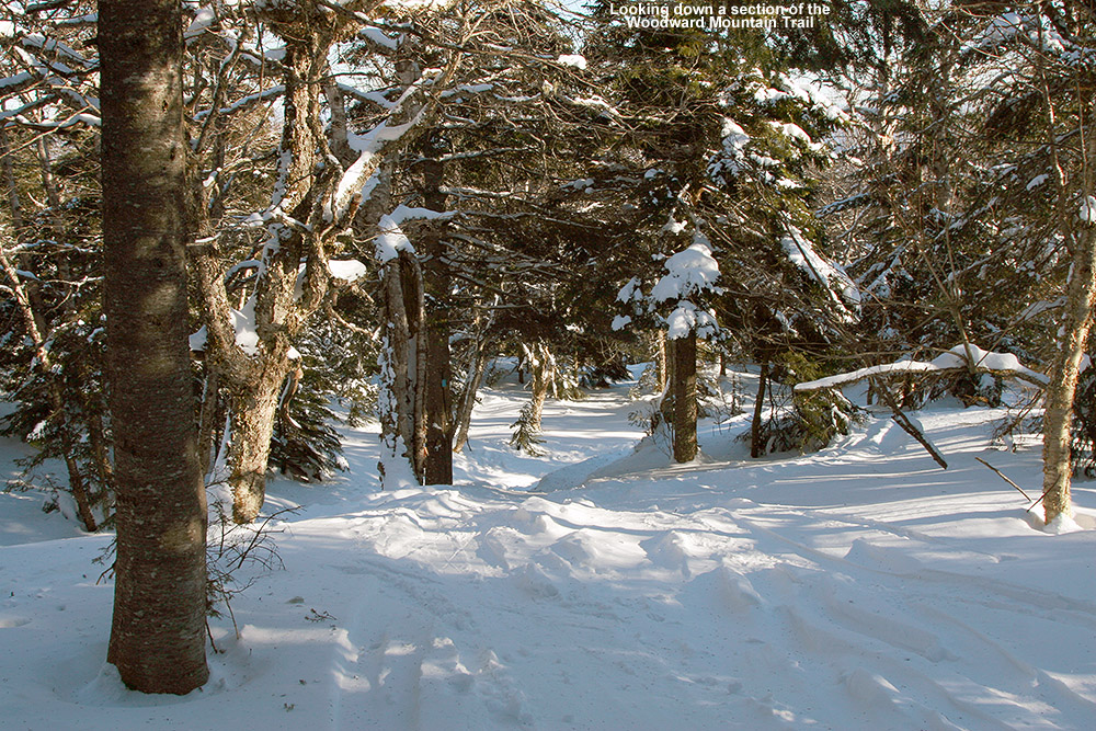
When snow conditions are good, and the snowpack is like this from top to bottom, it’s a great time to consider some of those longer backcountry descents that really make use of all the vertical around here. The trip that came to mind today was the Woodward Mountain Trail. E was feeling a bit under the weather, but I figured I could take the boys on the tour, and E said she could still help out with the car shuttling. We didn’t have a full day to spend, so I wasn’t going to initiate the tour unless we could get it done fairly expeditiously. I’d scoped out the bottom of the trail and found the most efficient exit on a tour last March, but my touring in the Goose Pond area had only gotten me mildly familiar with the start of the trail up on the ridge line. I decided to check my copy of David Goodman’s classing backcountry guidebook “Backcountry Skiing Adventures: Vermont and New York” to get a better feel for the ridgeline part of the trail. After the initial descent from the Vista Peak Fire Tower the guidebook mentions that the trail “climbs gently, but steadily up a ridge”. That was enough to convince me that I needed to do a bit more reconnaissance before bringing the boys, so I set my sights for today on an exploratory tour along the ridge line.
“The snow there was spectacular bottomless powder with no tracks.”
Arriving at Bolton Valley, my tour kicked off with a ride on the Vista Quad, which whisked me right up to the Vista Summit. I stopped in to check on the views from the Vista Peak Fire Tower, and then continued on the Woodward Mountain Trail. The first few minutes were on terrain that I’d been on before – the descent from Vista Peak down to the col that separates it from Woodward Mountain. As advertised, the trail rose gradually after that point. I opted to go without skins for a few minutes, but eventually decided that putting on my skins would be the way to go. I’d say that was the right choice, because there was at least another 10 minutes of climbing before the trail began to level off. I followed the trail out to the point where it began to descend through some of the route’s open glades, then turned around and headed back up to the Woodward Mountain summit area.
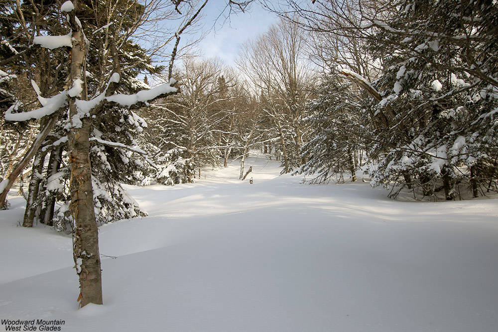
Some of the open glades on the west side of Woodward Mountain
I still had a bit of time to explore, so I decided to check out some of the glades on the west side of Woodward Mountain as well. I followed a prominent spur trail the headed west off the Woodward Mountain Trail, and it eventually led down to some nice open glades dropping into the prominent valley that drains Goose Pond and is surrounded by Bone Mountain, Woodward Mountain, Vista Peak, and the Timberline Summit. The snow there was spectacular bottomless powder with no tracks. It was hard to pull myself away, but with the time I had available I had to skin back up to the Woodward Mountain Trail after only a partial descent of the glades. An excellent tour option would be to continue skiing on down the valley and hook back up with the resort by connecting to the Timberline Base the way we did on our Bone Mountain tour. That potential tour will have to wait for some time in the future though, so I’ll just have to add it to the ever growing list along with the Woodward Mountain Trail.
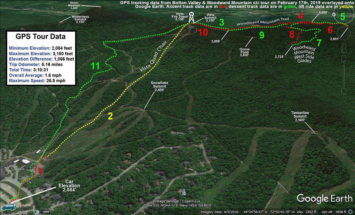
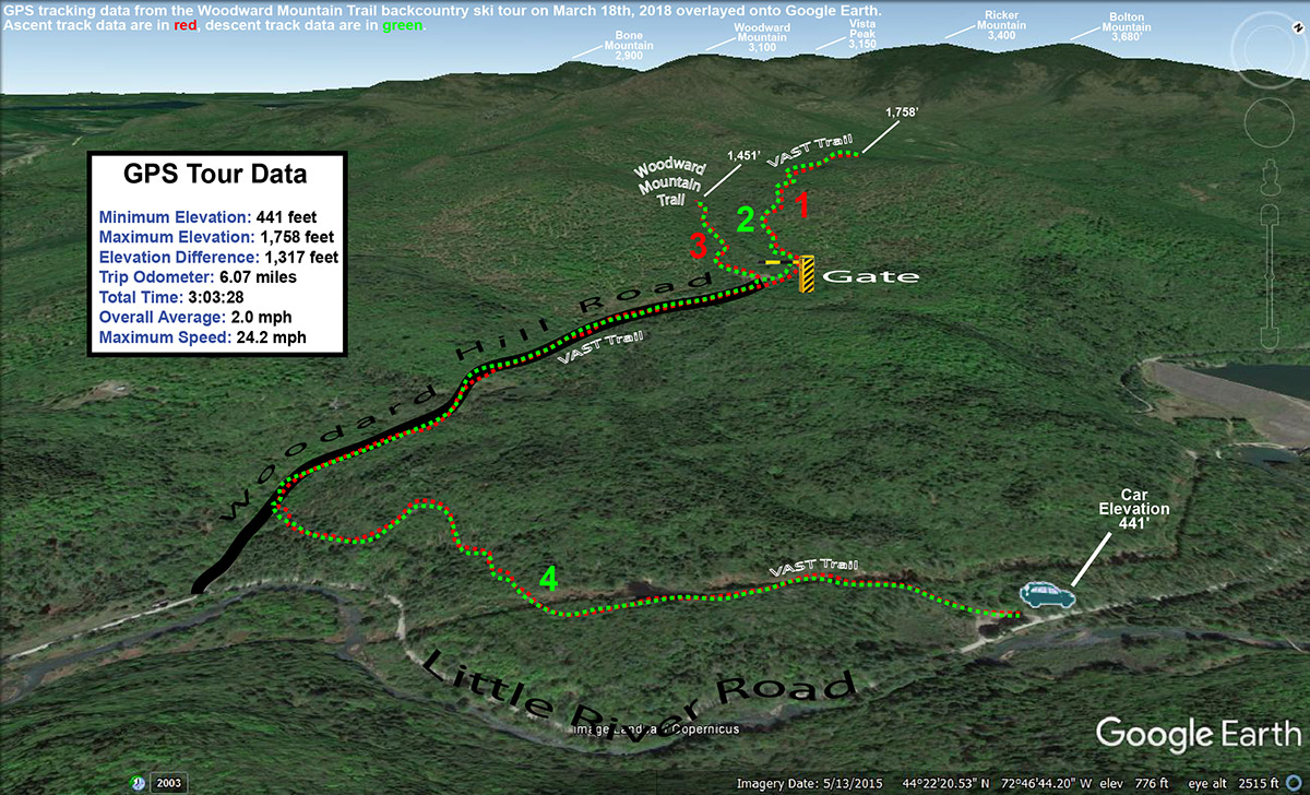
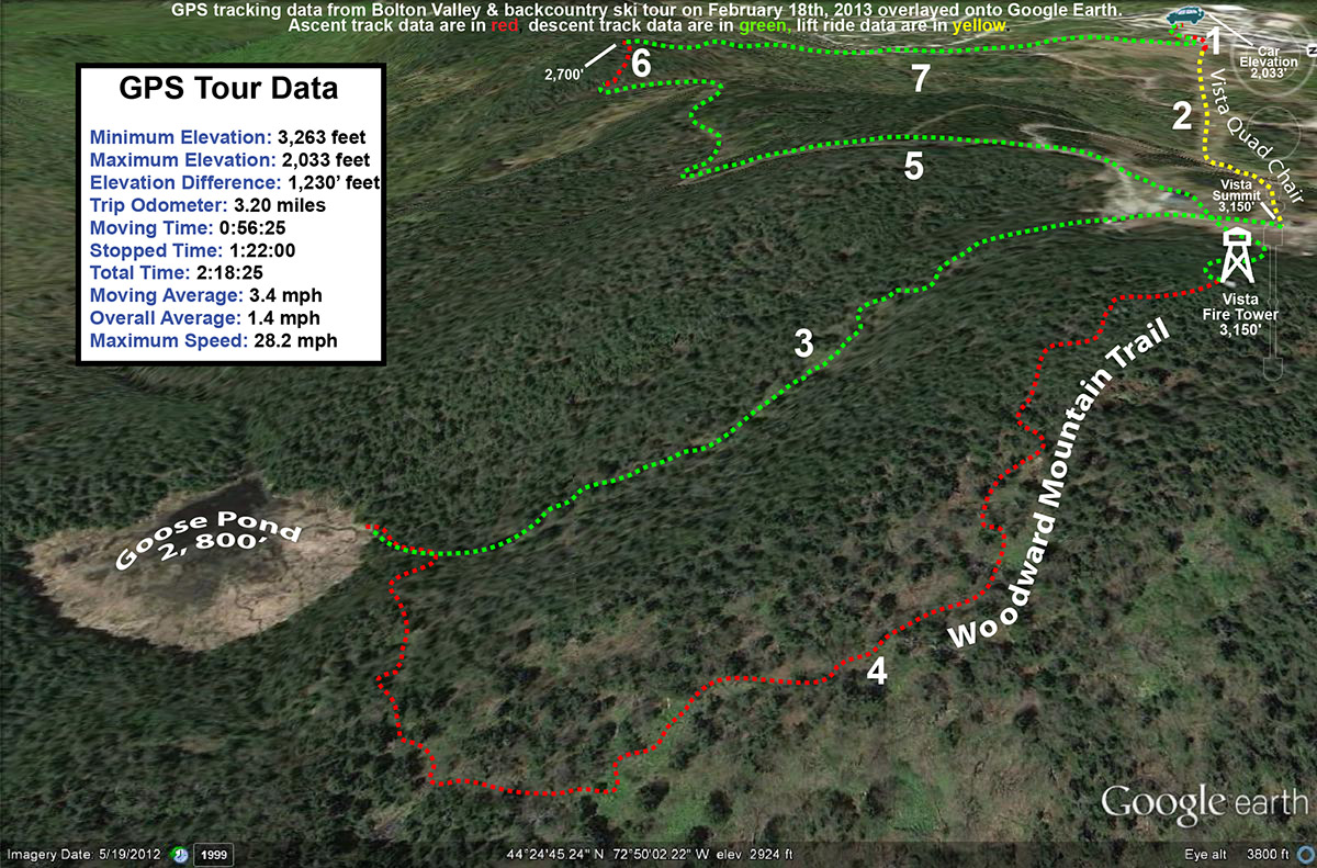
A map with GPS Tracking data from today’s ski tour at Bolton Valley and the Woodward Mountain Trail overlayed onto Google Earth
Powder turns today during explorations in the lower elevations of the Woodward Mountain Trail
Wind chills were forecast to approach -30 F today on the upper elevations of Mt. Mansfield at Stowe Mountain Resort, so E did a “soft cancel” of our BJAMS ski program. The program was still on, and families could go if they wanted to, but no coaches were required to go, and students wouldn’t have to deal with those potentially frigid temperatures.
Although I was glad to not have to battle the nasty wind chills up in the higher elevations, it was still a gorgeous late-winter day out there, so I thought about heading out for a ski tour on something local, relatively low elevation, and sheltered from the wind. Eventually, an exploration of the lower elevations of the Woodward Mountain Trail came to mind. The base of the trail is just a couple miles from our house in Waterbury, and with the healthy snowpack that extends all the way to the bottom of the local mountain valleys, the ski conditions there should be outstanding.
The Woodward Mountain Trail is quite a route, running six miles and dropping over 2,500 vertical feet in elevation. The traditional way to ski the trail is to spot a car at the VAST parking area (450’) at the bottom on Little River Road near the Waterbury Reservoir, then drive up to Bolton Valley Resort and use the Vista Quad to get to the top of Vista Peak (3,150’). From there, you ski southward along the ridge between Vista Peak and Woodward Mountain, before descending eastward off the flanks of Woodward Mountain itself down to Little River Road in the Waterbury Reservoir and Little River State Park area. I’ve skied the upper elevations of the trail before, but I’ve heard route finding for the ending (and middle for that matter) portions of the trail can get a bit tricky. At some point it would be great to get family and friends together for a full run of the trail, so my goal with today’s outing was to orient myself to the twists and turns at the bottom of the trail to hopefully make that experience a bit more efficient. And with the great snowpack and plenty of powder out there, I hoped to get in some good turns in the process.
“…my goal with today’s outing was to orient myself to the twists and turns at the bottom of the trail to hopefully make that experience a bit more efficient.”
I used my copy of David Goodman’s classing backcountry guidebook “Backcountry Skiing Adventures: Vermont and New York” to get myself oriented with respect to the lower regions of the route. His book has a nice description of where to park, as well as a topographic map with the route outlined. The guide is excellent, with just one problem in my case – the guide is built for following the trail down, so it’s not perfect for guiding you up from the base of the trail if you want to try that approach. In any event, with the map from the guidebook and my GPS in hand, I knew I’d be able to orient myself reasonably well to what the bottom of the trail held in store, and I’d always be able to come back again if necessary on a future trip with my own first experience in hand.
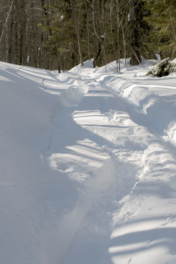
Temperatures were probably around 20 F when I parked at the VAST lot on the west side of Little River Road. There were a few cars there, most with snowmobile trailers of course, although one car looked like it might be backcountry skiers waiting to pick someone up. Starting from the parking lot, you’re immediately on the VAST trail, and it climbs a steep pitch before leveling out and going through some fields along the power line leading up to the dam. It was easy to see from the map in the guidebook that this part of the trail is a bit circuitous – you’re doing a big loop that doesn’t immediately bring you toward the rest of the Woodward Mountain Trail. This is due to the layout of the VAST trails, but with the topography of the ridges, valleys and streams down there, you’d probably just waste a ton of time trying to break trail through the snow if you wanted to follow more direct route from the parking area anyway. It’s hard to put a price on having a packed, well-marked trail to get you through the backcountry, even if the route is a bit indirect. The energy-saving and route-finding efficiency of having an established packed trail are simply huge. I was a bit dismayed to find that there was one fairly substantial downhill section (which of course means uphill on the way out) on the route in. I’m talking about a substantial enough slope that you’re likely going to have to take off your skis and walk, or put your skins on to deal with it.
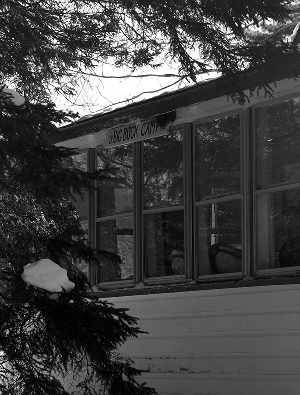
After 0.9 miles on the well-packed VAST trail, I came to a T junction. The trail I was intersecting was part of the VAST system, but it was also a road, Woodard Hill Road. It had actually been groomed (and apparently even plowed) down in that area, so the snow cover was a bit thin in spots. I headed upward and to the right on Woodard Hill Road, which was the obvious route to take based on the guidebook map. I passed a couple of hunting camps on the left, and eventually at 1.75 miles into the route I came to a gate that seems to be the one indicated on David Goodman’s route. This is where the utility of the map in his guidebook broke down a bit for the ascent. His route appears to be shown passing through the gate, but it’s also shown staying to the south of the main drainage in that area. If you go through that gate, you’re crossing a bridge to the northerly side of that drainage, so those two pieces of information don’t line up. On the south side of the drainage there is a clearing that had seen some snowmobile activity, but I didn’t see any obvious ski tracks coming down from there to suggest it was near the Woodward Mountain Trail.
One of the hunting camps seen during my ski tour along Woodard Hill Road
I decided to play it safe on my first look and simply follow the VAST trail through the gate to see if any obvious trails branched off from it. The “safe” aspect of this choice was that I could continue to follow a well-packed, well-marked trail for a while, wherever it was going to take me. At 2.65 miles and an elevation of ~1,750’, I hit the local peak of that VAST trail and hadn’t seen any obvious trails converging on it, so it was time to see what potential the clearing on the other side of the drainage held. I de-skinned and switched to descent mode, and actually had some fun turns in the terrain off the sides of the VAST trail.
“At the very start of my tour down around 450’, the powder was generally 8 to 12 inches deep, but up in the 1,500’ to 2,000’ range where I topped out it was in excess of 20 inches deep. So there were a lot of good turns today at all elevations.”
Coming back down to the gate and bridge area, I headed up into the clearing and could see what had to be the outlet of the Woodward Mountain Trail. The clearing was full of powder, and the reason I hadn’t seen any ski tracks coming out among the snowmobile tracks was simply due to the fact that the last person to use the trail had done so before our recent bout of snowfall had stopped. Once I looked up the trail, I could see that there was an obvious ski/skin track. I put my skins back on and started up the trail. Fortunately, only about 6 to 7 inches of light fluffy snow had accumulated since the last person’s track, so breaking trail wasn’t really too much of a chore. I ascended for a bit within what my schedule allowed, and then had a nice ski back down that section of the trail with some smooth powder turns.
Back at the VAST trails, I descended until I hit the VAST stop sign at the junction of the final leg back to the parking lot. I was reading Ski Maven’s report of her trip on the Woodward Mountain Trail, and it sounds like her group went right through this junction, which left them at the base of Woodard Hill Road about a mile from the parking lot where they had spotted their car. This meant that they had to walk that distance back on Little River Road to get to where they’d parked. Froom that VAST trail junction though, it’s really a short downhill jaunt (just a couple tenths of a mile) to get to the base of Woodard Hill Road. This would actually be a much better place to park a car for finishing the Woodward Mountain Trail. Unfortunately, there’s not the expansive VAST parking area that you get following the other route, but I’ve seen cars parked down at the base of Woodard Hill Road, and I’m sure that’s why. I can tell you, having returned the 0.9 miles to the main parking lot on my tour today via the standard route in the guidebook, with its one substantial uphill and extensive flat sections, that continuing down on Woodard Hill Road would be tremendously more fun and efficient. It shortens the travel at the end of the route by almost a mile, and it’s all downhill. Even if parking isn’t available at the bottom of Woodard Hill Road, and you had to park at the VAST lot, you could still have everyone in your party continue that way and have one strong member follow the regular route and pick the rest of the party up at the road. It would honestly give people a much more enjoyable finish to their tour.
A Google Earth map with GPS tracking data showing today’s tour on the Woodward Mountain Trail
At the very start of my tour down around 450’, the powder was generally 8 to 12 inches deep, but up in the 1,500’ to 2,000’ range where I topped out it was in excess of 20 inches deep. So there were a lot of good turns today at all elevations. At some point I’d like to get to the middle portions of the Woodward Mountain Trail, but I’ve now learned a lot about the layout of the upper and lower sections, and would definitely feel comfortable guiding people in those areas. The middle portion of the route is supposed to have a lot of fun glades though, so I can’t wait to check those out.
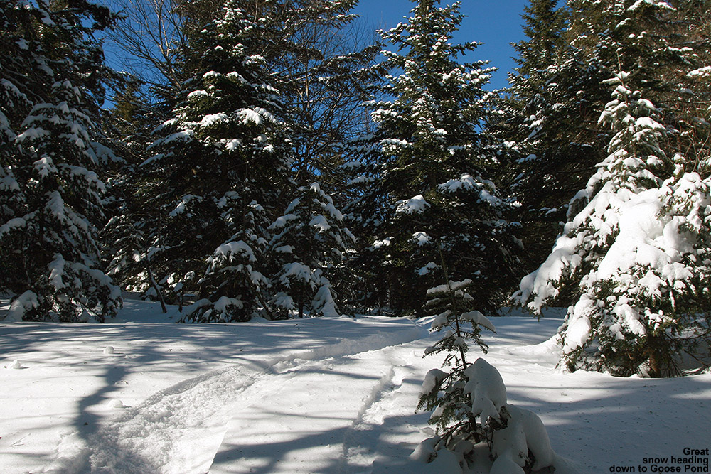
Getting in some nice turns on the way down to Goose Pond today
The weather was quite nice on Saturday, so we had a good family backcountry outing at Bolton Valley, but the weather yesterday was simply nasty. I contemplated heading up for a quick tour, but when I saw that the Bolton Valley Village temperature was at 3 F around midday, I wasn’t all that inspired. When I checked again in the afternoon, I saw that it had actually dropped a degree to 2 F. As if the cold temperatures weren’t enough, there was a hefty wind for good measure, and it was strong enough that the Vista Quad seemed to be closed for much of the day. With that going on outside, it was extremely nice spending much of the day getting things done inside instead.
“…the powder was very much like what we found on Saturday – a general 8 to 12 inches, and there was no internal melt layer
up at that elevation.”
Today’s temperatures were definitely expected to improve though, so after I took care of some work in the morning, I planned on a short tour up at Bolton Valley in the afternoon when the day’s warmth would be at its peak. Under a cloudless sky, temperatures were up into the mid 20s F in the valleys, and close to 20 F even up at 2,000’ when I arrived in the Village in the early afternoon. There was still plenty of wind though, so Mother Nature didn’t seem to want to let that go for some reason. Fortunately, the winds weren’t strong enough to shut down the Vista Quad (yet), and that let me proceed with my planned tour.
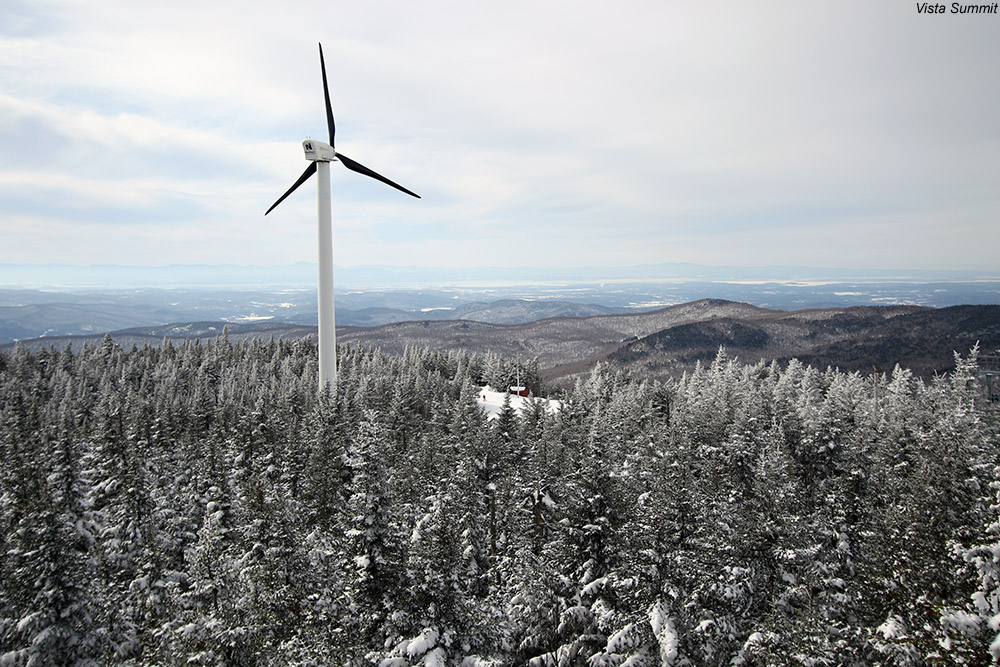
For today, my goal was to explore the drainage that dropped off behind the Bolton Valley Wind Turbine and led down to Goose Pond. From the pond, I planned to hook up with the Woodward Mountain Trail, connect back to the Vista Summit, and make a front side run back to the Village. The wind was a little brisk as I prepared my gear at the car, so I went with my thicker fleece layer in anticipation of what might be going on up above 3,000’. The resort was definitely winding down in activity from the holiday weekend, and there were only a few people around as I boarded the Vista Quad. It was my first time on the Vista Quad this weekend, and the lift ride was certainly enlightening, albeit somewhat discouraging. The combination of holiday traffic, but probably even more so the strong westerly winds, left the snow surfaces pounded flat, flat, flat. Everything looked packed out; even the trees along the Vista Quad Lift Line seemed to have lost a good part of their fluffy disposition. The resort had that look of an “old snow” scene, with the trails stripped of loose snow, the tree branches devoid of fluff, and even slick patches visible here and there. I was thankful that I was heading to the leeward side of the mountain, but the snow seemed so beaten down it seemed hard to imagine that I’d find fluff even there. The lift slowed down and even stopped a few times on my trip up, presumably because of the wind, and I was thankful that I was only planning one ride because I wondered how long they’d be able to keep it turning.
Once at the Vista Summit I headed over to the wind turbine, then passed underneath it into one of the openings in the forest. Above the noise of the wind itself, the turbine was cranking away with its own sound of spinning blades. It was really moving in winds that had to be 25 to 30 MPH, and I was happy to see it free of rime and actually doing its job. The noise of the turbine blades in the wind was substantial enough that it actually took a while to fade as I dropped into the drainage and began my descent, but after a few minutes of navigating downward the noise diminished to just the wind itself. Finding a route through the gully was actually quite easy, as there were obvious open areas that could be connected. I can’t say that I found one continuous line for skiing, but there were enough open areas to make it enjoyable. A little trimming to connect those areas would make for an even better descent. At first I was concerned about the scoured and wind-packed snow that presented itself on the initial drop from the turbine, but that dissipated and only reappeared in a few exposed spots lower down. Other than that, the powder was very much like what we found on Saturday – a general 8 to 12 inches, and there was no internal melt layer up at that elevation. The forest I encountered was a mixture of evergreens with a few hardwoods and a touch of brush here and there, and as I approached the pond down at around 2,800’ it became one of those dark spruce groves that permit little understory growth.
Checking out the Woodward Mountain trail as I continue my ascent
Down in the open area of the pond, I found myself exposed to the wind, and it was really ripping. What I observed was a rather austere, winter scene, but not quite the peaceful place it might have been without the incessant wind. I stayed just long enough for a couple of pictures before I retreated into the shelter of the spruce forest. I put on my skins for the ascent, and found an easy route through the spruce; the trees were tall and the only hindrance was the occasional presence of dead lower limbs that hadn’t yet fallen off. With the help of my GPS, I hit the Woodward Mountain Trail in about 10 minutes, and my pace accelerated at that point because I found that there was a skin track that others had used for ascent. There were a few ski tracks on the trail itself as well, but it hadn’t been used too heavily. It was easy to see that the trail was designed well though, because it was often just on the leeward side of the ridge and held a lot of powder. The trail is rather wide in spots, up to 50 feet or more, so I’m sure the turns through there are a great way to start off a tour of the entire trail down to Waterbury Reservoir.
Just before finishing my ascent and emerging back out at the Vista Summit, I hit the fire tower and headed up to take in the view. The wind was intense up top, probably 40-50 MPH, but I was able to get a few photos of the great views in every direction. I quickly got down, took my skins off my skis for the front side descent, and to my surprise (although I guess with those winds not too surprising) when I emerged at the Vista Summit I saw that the Vista Quad was entirely shut down. It was almost spooky how deserted the summit looked for that time of day, but I basically had the whole upper mountain to myself at that point. I headed over toward Cobrass for my descent, and I’m not sure how long the lift had been closed, but the trails had already received a resurfacing due to snow sifting in on the wind. The surface of Cobrass was actually quite nice; it was very easy to dig with my edges, even on my fat skis, and I enjoyed my solo descent.
I headed into the Villager Trees and up “The Crack” to the top of “The Knob” to get in some additional powder turns on my way back to the Village. Folks have been busy in that area in the off season, because I could see some new lines in there that looked like fun. I stuck to a line that I knew, and nobody had been in that area yet so the tracks were fresh. The powder was generally good, although there were some spots where the wind had gotten to it, and I could really feel the assistance I got from the rocker and width of my AMPerages in handling that crust. Down in the lower sections of the trees there had been a lot more traffic, and combined with the wind I had to do a little more work to find the best untracked snow. Those lower sections seemed to fly by though, as I found myself going fast through areas with packed snow and less powder.
GPS track of today’s ski tour mapped onto Google Earth – click for full size image
I finished off my run, stopped in the main base lodge briefly, and then headed to the car. I was surprised to find that the wind had virtually disappeared down at the Village level, despite the way it was cranking along up high. The lower mountain lifts were running, but many folks seemed to be winding down their day as it was getting toward that 4:00 P.M hour. It was in the low to mid 20s F at the base – warmer than it had been when I arrived, and it felt very nice without the wind. It had definitely been cold up high though – my cheeks could still feel that bite that comes along with cold winter air. In terms of upcoming weather, we’ve still got a good chance for some upslope snow during the midweek period. That’s good, because the lift-served slopes could really use a freshening based on what I saw today.


