Stowe, VT 27OCT2018

An image of snow sliding off a roof in front of the Mansfield Base Lodge at Stowe Mountain Resort in Vermont as an October nor'easter affects New England
An image the Crossover trail and mountains in the background at Stowe Mountain Resort during an October snowstorm
Views on my ascent of the Crossover trail with the mountains in the background obscured by snowfall

It’s been quite a while since I last used my “rock skis”.  Although I’ve certainly gotten out for many early- and late-season turns over the past several seasons, I just haven’t had to worry much about conditions that were going to damage my skis.  Late-season snow is dense, for the most part covering rocks where it’s present, and our early-season storms of late have generally been substantial enough that I wasn’t concerned about rocks on the terrain I was skiing.  This year has been a bit different here in the Northern Greens though, and rock skis turned out to be just the right choice for today’s outing.  We’ve had numerous rounds of snow in the mountains over the past couple of weeks, but none of the storms have been the type that really put down a big dump of 6 to 12 inches or more at once.  New Hampshire did get a big shot of snow from the last storm that hit, but over here in the Greens we’ve just been adding an inch or two here and there.  Those smaller bouts of snow have added up over the past couple of weeks though, and with the nor’easter affecting the area today, it finally seemed like it would reach that threshold of base depths to lure me out to the slopes.

“Up by the Mountain Chapel, the 3 to 4 inches of dense snow on the smooth surface of the Toll Road really produced some excellent floaty turns.”

There wasn’t a lot of cold air around ahead of this nor’easter, so the forecasts called for at best a few inches of snow in the higher elevations.  Based on Powderfreak’s Stowe reports however, there were 3 to 5 inches of snow already on the slopes at Stowe, and even a couple more would be enough to get me interested in checking out the potential for some turns.

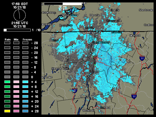
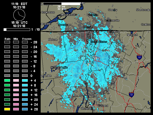
As the nor’easter approached, snowfall at our house in Waterbury began mid-morning, and then in the midafternoon Mother Nature really turned on the spigot and we got into a period of heavy snowfall composed of big wet flakes up to 2 inches in diameter.  With the heavy snow falling it seemed like as good a time as any with respect to catching any new accumulations on the slopes before any potential mixed precipitation.  I was planning to take an initial look at Bolton Valley to see how the snow was up there, but the Bolton Valley Access Road still hadn’t been plowed as I started up, so I didn’t go very high before I decided it was best to turn around.  There was no way I wanted to try heading all the way up to the Village above 2,000’ on an unplowed road.

An image of the Mansfield Base Lodge at Stowe Mountain Resort in Vermont with snowfall during an October storm
Mansfield Base Lodge

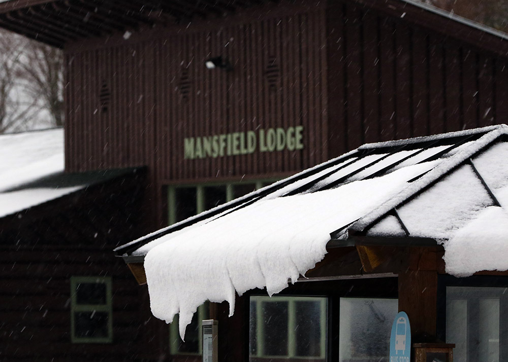
In line with my plans, I next headed off to Stowe for some skiing, and I was fairly confident that the driving would be fine with the route at mostly low elevation.  Indeed the driving was fine, and unlike Waterbury, the town of Stowe really hadn’t picked up any snow, so that made the drive very easy. Rain through the valley switched to mixed precipitation as I approached the base elevations of the resort at 1,500’, and I found a solid covering of 1 to 2 inches of snow on the ground at the Mansfield Base Lodge where I parked.  I’d brought two pairs of skis and skins, and after surveilling the area I decided that the rock skis were the way to go for a more enjoyable descent because I wouldn’t have to work too hard trying to avoid any rocks.

An image of a small evergreen with snow on its boughs during an October snowstorm at Stowe Mountain Resort in Vermont
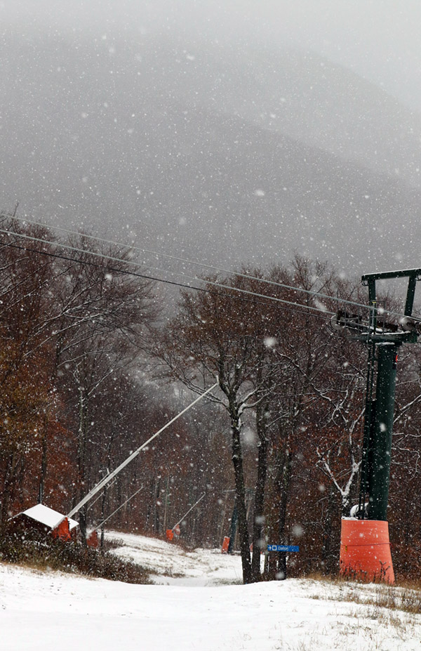
I wanted some mellow, grassy slopes for my tour, so I headed up in the area of the Mountain Triple Chair toward the Stowe Mountain Chapel.  The mixed precipitation that I’d found when I first arrived changed over to all snow as I began my ascent, and I really needed the hood of my coat at times due to the intensity of the precipitation.  I quickly found 3 to 4 inches of snow on the grassy slopes, which is about where the depth stayed up to the Mountain Chapel at ~2,300’.  Although I could have used my skins, I never really needed them because once I got up to the Crossover road I was able to simply walk in my Tele boots easily.

An image of the Mountain Chapel in an October snowstorm at Stowe Mountain Resort in Vermont
Stowe Mountain Chapel along the Toll Road

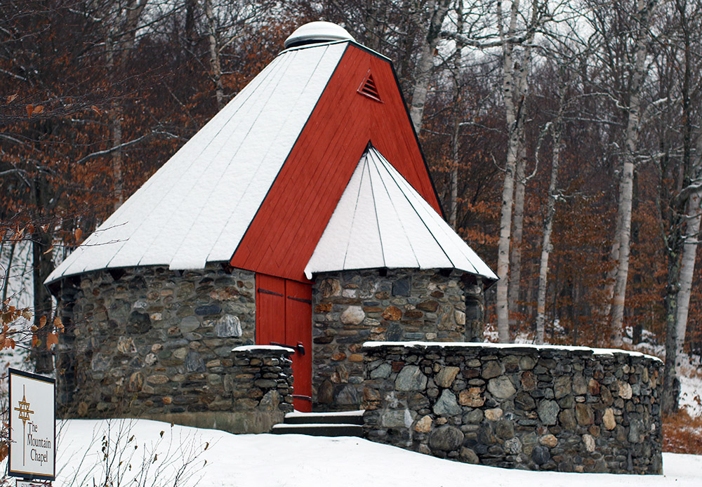
I really thought that the grassy slopes would offer the best skiing, but it turned out that the service roads were the best.  Up by the Mountain Chapel, the 3 to 4 inches of dense snow on the smooth surface of the Toll Road really produced some excellent floaty turns.  The Crossover Road isn’t nearly as smooth, and the snow depths did drop a bit on the descent, so nothing compared to the turns up on the Toll Road.  On the grassy slopes, the depth of the cut grass relative to the few inches of snow, combined with my fairly skinny rock Tele skis, made turns much more challenging.  I was low enough down in the grass that there was substantial resistance to making any short-radius turns.

An image of a plow spraying some very slushy snow at Stowe Mountain Resort in Vermont after an October nor'easter snowstorm
Plowing some snow so slushy it looked like water in the Stowe parking lot

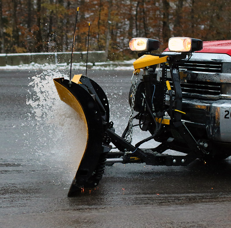
The snowfall had let up for the most part by the time I’d descended back to the base, but the weather show wasn’t quite over.  I got to see some plowing of the parking lot, and the slushy snow was so wet that it was almost as if the plow was simply plowing water!  This was the 4th storm with accumulating snow at our house this October, and based on my count, it was the 6th storm with snow for the mountains, so we’ve really had quite a run.  It might not be the last of our October snow though; we may get a couple of chances through midweek before we get into a slightly warmer pattern heading into November.

Potent October snowstorm hits parts of Northern New England

On Tuesday, a fairly compact low pressure system formed off the New England coast and spread snowfall back into parts of Northern New England.  During the afternoon, mixed precipitation was falling at roughly the 1,500’ elevation near the bases of local resorts like Sugarbush and Stowe, with the accumulating snow line around 2,000’.  At the end of the day, Powderfreak sent in a nice picture to the NNE thread at the American Weather Forum showing the snow line at Stowe’s Gondola area.

The most impressive accumulations came on Tuesday night, with Wednesday morning revealing 5.1 inches in Derby Center, VT, 7 inches at Pinkham Notch, 11 inches of new snow in Randolph, NH, 17 to 18 inches in Tuckerman Ravine, and 18 inches atop Mt. Washington at the observatoryWildcat ski area picked up roughly a foot of snow and plans to open on Saturday with top-to-bottom skiing.  Back here in along the spine of the Northern Greens, Powderfreak was reporting 3 to 4 inches of snow for the upper elevations of Mt. Mansfield by Wednesday evening.

As of this evening, we picked up a bit of accumulation at our house in Waterbury, and Powderfreak was reporting a general 3 to 5 inches of total snow accumulation on Spruce Peak at Stowe.

There’s apparently a Nor’easter brewing for this weekend, although there’s not a ton of cold air around for the system to use, so the current forecast suggest snow will only be up near the summit elevations and fairly limited in amount.

More Vermont snow on northwest flow

A weather radar image showing upslope snow coming into the Green Mountain of Vermont from the northwest in an October snow event
A weather radar image from midday on Sunday showing the continuous push of moisture from the northwest hitting the Northern Green Mountains and giving us continuous light snowfall.

After a simply gorgeous fall day on Saturday, Sunday kicked off cold and blustery, and once the snow showers got started in the morning, they literally kept going all day with that classic upslope flow from the northwest.  There were still a few flakes coming down, even around midnight last night.

We had numerous rounds of transient snow accumulations during the day, and it stuck around better after dark when the temperatures had dropped a bit, but there was still nothing around as of this morning.  I recorded one of the early 0.1” accumulations, and then a 0.2” accumulation later in the day after one of the heavier bouts of snowfall, but what I found in the rain gauge this morning was a bit under 0.01” so liquid goes down as a trace.

“…once the snow showers got started in the morning, they literally kept going all day with that classic upslope flow from the northwest..”

This event was the second accumulating one at our house this month, and the fourth one for the mountains.  Looking ahead, there seems to be some potential for snow in the midweek timeframe, and then again out toward the weekend.

Additional rounds of snow for Vermont

Since mid-month, our weather pattern has shifted to a more seasonable, and even below average one with respect to temperatures here in Vermont.  After our first mountain snows of the season over the weekend, there was a touch of snow Tuesday night in the upper elevations to put down the second coating of the season.

This season’s most notable snowfall so far affected the area from Wednesday into Thursday.  Colleagues of mine at UVM reported seeing frozen precipitation for a time around midday Wednesday, and as the afternoon wore on, snow levels began to drop more consistently.  Snow levels were approaching the bottoms of the mountain valleys as evening approached, and by 7:00 P.M. we were starting to get accumulation at our house.  By Thursday morning we’d picked up 1.2 inches of snow to mark the first accumulation of the season at our house.

Killington opened for skiing today, and there are still additional chances for snow in the forecast over the next week, so we’ll be on the lookout for whatever wintry weather Mother Nature might bring our way next.


Average date of first snowfall for Mt. Mansfield in Vermont

Having recently picked up our first snowfall of the season here in Vermont, reports and discussion in the New England Regional Forum at American Weather had people wondering where this event sat with respect to the average date of occurrence for the first snowfall on Mt. Mansfield.  I’d been curious about that date as well, so I used the data from the Mt. Mansfield co-op weather observations site, which comes from the ridgeline of the mountain up near the 4,000-foot elevation.  It’s a fairly substantial data set that goes all the way back to 1954, and Wesley Wright set it up to be available through the SkiVT-L site at UVM.

“The data suggest that our first snow of the 2018-2019 winter season from this past Saturday (October 13th) is a few days on the late side of the mean for first accumulating snow (October 10th), but overall quite typical.”

There are a couple of seasons that I couldn’t include in the statistical analysis because of gaps in the data collection early in the co-op site’s history, but there were still 62 seasons in the data set that provided useful information.  The data suggest that our first snow of the 2018-2019 winter season from this past Saturday (October 13th) is a few days on the late side of the mean for first accumulating snow (October 10th), but overall quite typical.  The full results from the statistical analysis are below, so have a look and think snow!

Date of 1st Accumulating Snow at Mt. Mansfield, VT Co-Op Station:

Mean:  10/10
Median:  10/8
Mode:  10/17
S.D.:  15 days
n:  62
Earliest:  8/28/1986
Latest:  11/17/1985

First snows of the 2018-2019 winter season in the Green Mountains of Vermont

An image showing Camel's Hump in Vermont with the first snows of the 2018-2019 winter season in the Green Mountains
Camel’s Hump showing signs of the first snow of the season for the Green Mountain of Vermont

While the first half of October was fairly warm, the weather models have been suggesting a shift to more seasonal temperatures as we hit mid-month.  The potential for some mountain snow was in the forecast last night, and indeed as of yesterday afternoon snow was already being reported at Whiteface Mountain across the lake with video of the flakes.  Here on our side of the lake, we heard from Powderfreak early this morning that snow had been sighted in the mountains around Stowe, and he was heading up for some investigation.  An hour or two later, he had send along pictures, and indicated that accumulations on Mt. Mansfield were about a half inch and started at an elevation of roughly 2,300 feet.

“…it looks like we’ll have more opportunities for snow this week with accumulations potentially even down to the mountain valleys.”

Here at our house, I did a morning check to find that the cloud ceiling was still only about 2,000 feet and there were no obvious signs of snow below that level.  I gave the clouds some time to think about clearing a bit, and then headed out in the neighborhood during the mid-afternoon period to see what snow might be visible.  Indeed the cloud ceiling had risen by about another 2,000’ and I was able to catch Camel’s Hump as the clouds had just about broken away.  The snow line at that point looked to be around 3,000’.

The first snows of the 2018-2019 winter season are in the books here in the Greens, and the National Weather Service Office in Burlington says it looks like we’ll have more opportunities for snow this week with accumulations potentially even down to the mountain valleys.  We’ll see what transpires as even colder air moves in, so stayed tuned for more October snow updates!