
Over in the NNE thread at Americanwx.com, Powderfreak just mentioned the chance for up to 3 to 6 inches of snow in the next 36 hours, so we’ll be watching for that.
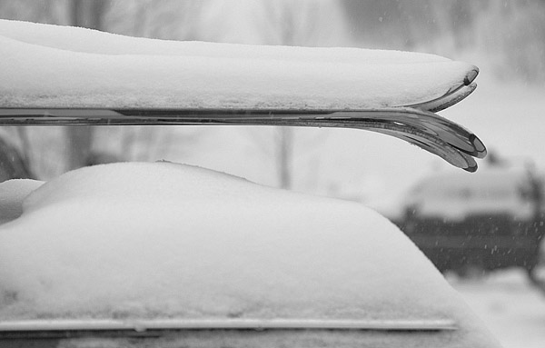
Snowing this morning
I just checked outside here and light snow is falling, but nothing that would accumulate at this point.
Stowe, VT 01OCT2009

For quite a while, the local weather gurus had been talking about the potential for local snow at the end of September/beginning of October. Yesterday, reports started coming in of white in the mountains, and from UVM I could see the tendrils of snowfall crashing out along the Green Mountain spine. It was looking like this morning would feature some real accumulations of snow, but yesterday evening the snowfall seemed to come to a halt. I started to reconsider my thoughts of taking a morning trip up to Mt. Mansfield, but sometime after dark I checked the local radar and it looked like snowfall was blooming again. I awoke this morning to see that there were still echoes on the radar, the temperature at the house was ~41 F, and our back deck was wet. I suspected there had been some additional snow on Mansfield, so I hopped in the car and decided that I’d at least go for a hike before work.
While I couldn’t see much white at all on my drive to the mountain, as I finally got close to Mt. Mansfield, I could see that there was a good covering of snow from about the middle elevations of Spruce Peak on up. I parked in the upper lot of the gondola (~1,600’) and there were a half dozen cars that looked like they could belong to other early morning folks checking out the snow. Snow was falling all around me, and while it wasn’t sticking at the base, I could see white on the ground not far above. At some point after 7:30 A.M., I strapped my skis on my pack and headed up Nosedive, hitting the snow line right around 1,800’. The depth of the snow didn’t increase too quickly, only up to maybe ½ to 1 inch in depth by the 2,000’ mark. I thought that the snow would probably be great for the junkboarders, but I wasn’t quite sure about those who were on regular skis. Not long after I had that thought though, I met three skiers coming down Nosedive, right around the intersection with National. They clearly seemed to be making due on regular skis and seemed to be enjoying it. During my ascent it snowed most of the time, and occasionally the snow came down with moderate to heavy intensity. Being starved for a bit of winter weather, I loved it.
Even by the top of Nosedive (~3,600’) the snow was only up to about 3 inches in depth, but I hiked on a bit farther to check out the Mt. Mansfield Stake. There was some vegetation in front of the stake (~3,700’) that hadn’t let the snow settle all the way to the ground, but the depth of the snow was clearly less than 6 inches. At least one vehicle had driven on the Toll Road, but I still popped on my old Telemark skis and did a little gliding in the untouched snow outside the tire tracks. That was quite pleasant, although due to the minimal snowfall, there was the occasional crunch of a piece of gravel. Not wanting to deal with the hassle of negotiating the steep terrain of Nosedive with somewhat minimal snow, I continued on the Toll Road and into the Ridge View area before deciding to take off my skis. I had even made a few Tele turns on the snowy grass, but by around the 3,000’ elevation, a combination of wanting to head back in the direction of the Gondola via steeper terrain, and not wanting to put any real damage into my skis saw me strapping them back on my pack. I’m not totally ready to commit the Hellgates to official rock ski status just yet.
Hiking up had been really enjoyable (I think it was the first time I’d hiked such a long distance in Tele boots without switching to skinning) but the vistas on the descent were spectacular. With the dramatic scenes of white surrounding me, and the brilliant colors in the valley, I stopped frequently to pull out the camera. My descent was somewhat meandering, taking me down through the Hayride and Lookout areas, before making it down to Crossover and down to the gondola lot. The snow level on Mansfield looked like it had crept up a few hundred feet since my ascent, so it was certainly warming up. Insofar as I can recall, I think today’s outing was the first time that things came together to allow me to ski on my birthday, so that made it even more of a treat that usual. To check out all the pictures from the day, head to the Stowe trip report from today.
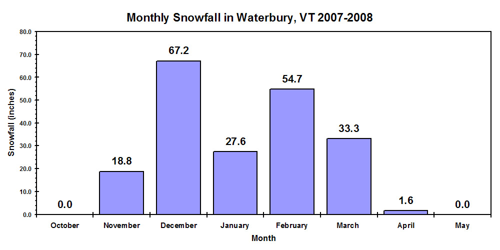
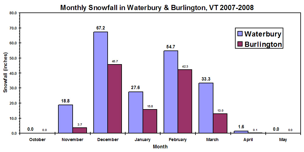
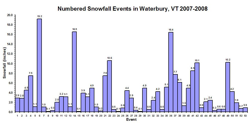
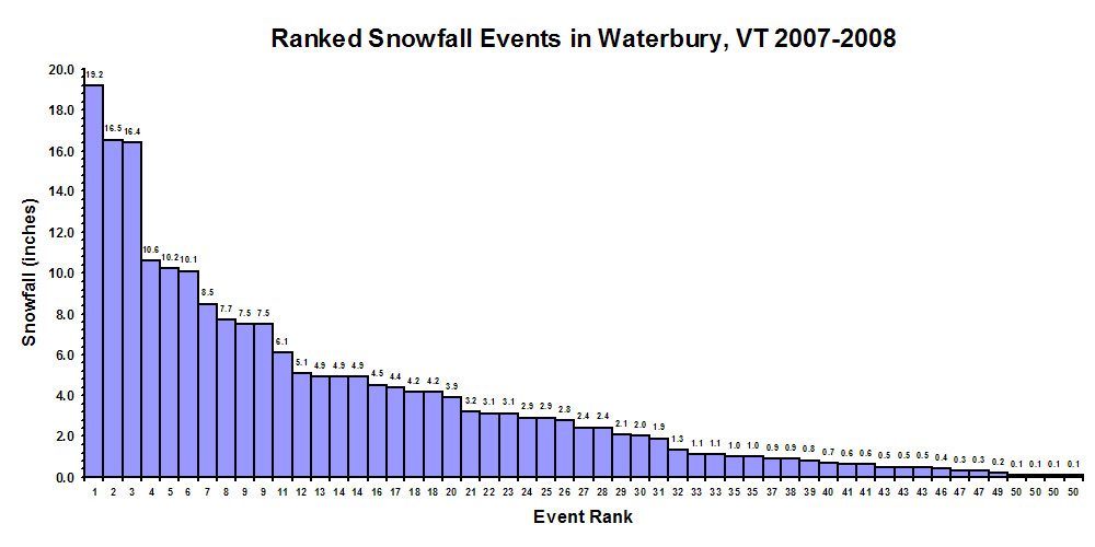
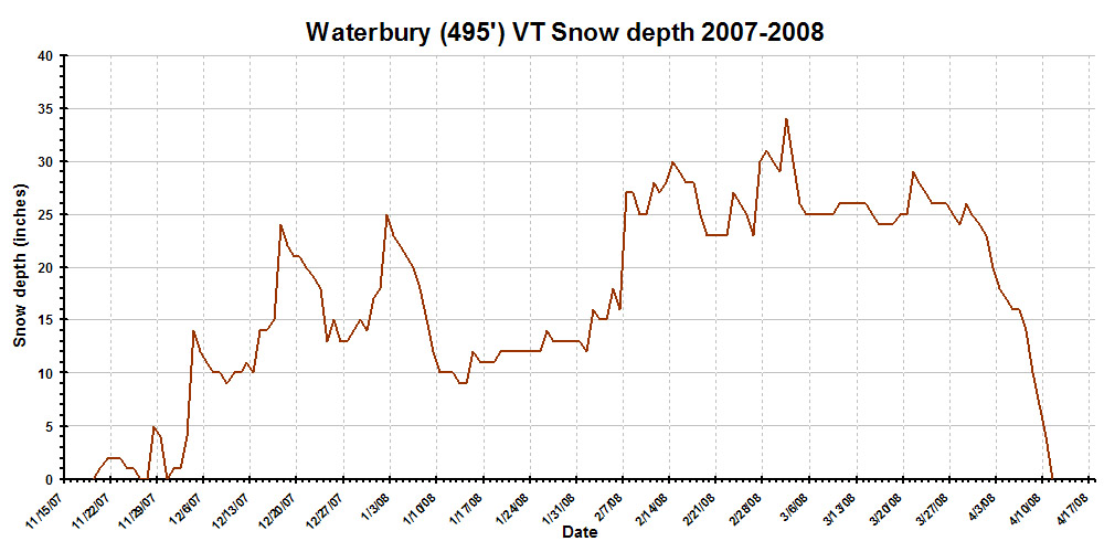
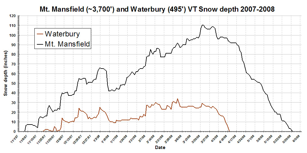
Waterbury, VT 2007-2008 winter weather and snowfall summary
Waterbury, VT 2007-2008 winter weather and snowfall summary
Elevation:
495 feet
How are the snowfall
measurements made?
|
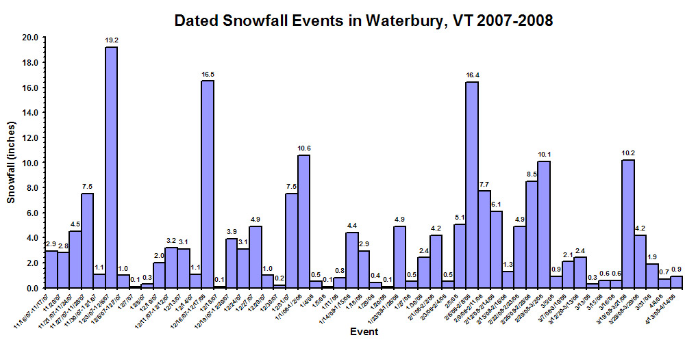
Waterbury snowfall and weather Top five snowfall events Notable low temperature readings |
|
Event |
Date(s) |
Snowfall |
Cum. |
|
1 |
2.9 |
2.9 |
|
|
2 |
2.8 |
5.7 |
|
|
3 |
4.5 |
10.2 |
|
|
4 |
7.5 |
17.7 |
|
|
5 |
1.1 |
18.8 |
|
|
6 |
19.2 |
38.0 |
|
|
7 |
1.0 |
39.0 |
|
|
8 |
0.1 |
39.1 |
|
|
9 |
0.3 |
39.4 |
|
|
10 |
2.0 |
41.4 |
|
|
11 |
3.2 |
44.6 |
|
|
12 |
3.1 |
47.7 |
|
|
13 |
1.1 |
48.8 |
|
|
14 |
16.5 |
65.3 |
|
|
15 |
0.1 |
65.4 |
|
|
16 |
3.9 |
69.3 |
|
|
17 |
3.1 |
72.4 |
|
|
18 |
4.9 |
77.3 |
|
|
19 |
1.0 |
78.3 |
|
|
20 |
0.2 |
78.5 |
|
|
21 |
7.5 |
86.0 |
|
|
22 |
10.6 |
96.6 |
|
|
23 |
0.5 |
97.1 |
|
|
24 |
0.1 |
97.2 |
|
|
25 |
0.8 |
98.0 |
|
|
26 |
4.4 |
102.4 |
|
|
27 |
2.9 |
105.3 |
|
|
28 |
0.4 |
105.7 |
|
|
29 |
0.1 |
105.8 |
|
|
30 |
4.9 |
110.7 |
|
|
31 |
0.5 |
111.2 |
|
|
32 |
2.4 |
113.6 |
|
|
33 |
4.2 |
117.8 |
|
|
34 |
0.5 |
118.3 |
|
|
35 |
5.1 |
123.4 |
|
|
36 |
16.4 |
139.8 |
|
|
37 |
7.7 |
147.5 |
|
|
38 |
6.1 |
153.6 |
|
|
39 |
1.3 |
154.9 |
|
|
40 |
4.9 |
159.8 |
|
|
41 |
8.5 |
168.3 |
|
|
42 |
10.1 |
178.4 |
|
|
43 |
0.9 |
179.3 |
|
|
44 |
2.1 |
181.4 |
|
|
45 |
2.4 |
183.8 |
|
|
46 |
0.3 |
184.1 |
|
|
47 |
0.6 |
184.7 |
|
|
48 |
0.6 |
185.3 |
|
|
49 |
10.2 |
195.5 |
|
|
50 |
4.2 |
199.7 |
|
|
51 |
1.9 |
201.6 |
|
|
52 |
0.7 |
202.3 |
|
|
53 |
0.9 |
203.2 |
|
Storm |
Storm |
Storm |
|
1 |
19.2 |
|
|
2 |
16.5 |
|
|
3 |
16.4 |
|
|
4 |
10.6 |
|
|
5 |
10.2 |
|
|
6 |
10.1 |
|
|
7 |
8.5 |
|
|
8 |
7.7 |
|
|
9 |
7.5 |
|
|
9 |
7.5 |
|
|
11 |
6.1 |
|
|
12 |
5.1 |
|
|
13 |
4.9 |
|
|
14 |
4.9 |
|
|
14 |
4.9 |
|
|
16 |
4.5 |
|
|
17 |
4.4 |
|
|
18 |
4.2 |
|
|
18 |
4.2 |
|
|
20 |
3.9 |
|
|
21 |
3.2 |
|
|
22 |
3.1 |
|
|
23 |
3.1 |
|
|
24 |
2.9 |
|
|
25 |
2.9 |
|
|
26 |
2.8 |
|
|
27 |
2.4 |
|
|
28 |
2.4 |
|
|
29 |
2.1 |
|
|
30 |
2.0 |
|
|
31 |
1.9 |
|
|
32 |
1.3 |
|
|
33 |
1.1 |
|
|
33 |
1.1 |
|
|
35 |
1.0 |
|
|
35 |
1.0 |
|
|
37 |
0.9 |
|
|
38 |
0.9 |
|
|
39 |
0.8 |
|
|
40 |
0.7 |
|
|
41 |
0.6 |
|
|
41 |
0.6 |
|
|
43 |
0.5 |
|
|
43 |
0.5 |
|
|
43 |
0.5 |
|
|
46 |
0.4 |
|
|
47 |
0.3 |
|
|
47 |
0.3 |
|
|
49 |
0.2 |
|
|
50 |
0.1 |
|
|
50 |
0.1 |
|
|
50 |
0.1 |
|
|
50 |
0.1 |
|
Date |
Waterbury |
Mt. |
|
9/1/2007 |
||
|
9/2/2007 |
||
|
9/3/2007 |
||
|
9/4/2007 |
||
|
9/5/2007 |
||
|
9/6/2007 |
||
|
9/7/2007 |
||
|
9/8/2007 |
||
|
9/9/2007 |
||
|
9/10/2007 |
||
|
9/11/2007 |
||
|
9/12/2007 |
||
|
9/13/2007 |
||
|
9/14/2007 |
||
|
9/15/2007 |
||
|
9/16/2007 |
||
|
9/17/2007 |
||
|
9/18/2007 |
||
|
9/19/2007 |
||
|
9/20/2007 |
||
|
9/21/2007 |
||
|
9/22/2007 |
||
|
9/23/2007 |
||
|
9/24/2007 |
||
|
9/25/2007 |
||
|
9/26/2007 |
||
|
9/27/2007 |
||
|
9/28/2007 |
||
|
9/29/2007 |
||
|
9/30/2007 |
||
|
10/1/2007 |
||
|
10/2/2007 |
||
|
10/3/2007 |
||
|
10/4/2007 |
||
|
10/5/2007 |
||
|
10/6/2007 |
||
|
10/7/2007 |
||
|
10/8/2007 |
||
|
10/9/2007 |
||
|
10/10/2007 |
||
|
10/11/2007 |
||
|
10/12/2007 |
||
|
10/13/2007 |
||
|
10/14/2007 |
||
|
10/15/2007 |
||
|
10/16/2007 |
||
|
10/17/2007 |
||
|
10/18/2007 |
||
|
10/19/2007 |
||
|
10/20/2007 |
||
|
10/21/2007 |
||
|
10/22/2007 |
||
|
10/23/2007 |
||
|
10/24/2007 |
||
|
10/25/2007 |
||
|
10/26/2007 |
||
|
10/27/2007 |
||
|
10/28/2007 |
||
|
10/29/2007 |
||
|
10/30/2007 |
||
|
10/31/2007 |
||
|
11/1/2007 |
||
|
11/2/2007 |
||
|
11/3/2007 |
||
|
11/4/2007 |
||
|
11/5/2007 |
0 |
|
|
11/6/2007 |
6 |
|
|
11/7/2007 |
7 |
|
|
11/8/2007 |
7 |
|
|
11/9/2007 |
7 |
|
|
11/10/2007 |
7 |
|
|
11/11/2007 |
7 |
|
|
11/12/2007 |
6 |
|
|
11/13/2007 |
6 |
|
|
11/14/2007 |
5 |
|
|
11/15/2007 |
4 |
|
|
11/16/2007 |
13 |
|
|
11/17/2007 |
15 |
|
|
11/18/2007 |
15 |
|
|
11/19/2007 |
0 |
14 |
|
11/20/2007 |
1 |
15 |
|
11/21/2007 |
2 |
16 |
|
11/22/2007 |
2 |
16 |
|
11/23/2007 |
2 |
24 |
|
11/24/2007 |
1 |
27 |
|
11/25/2007 |
1 |
24 |
|
11/26/2007 |
0 |
22 |
|
11/27/2007 |
0 |
20 |
|
11/28/2007 |
5 |
22 |
|
11/29/2007 |
4 |
22 |
|
11/30/2007 |
0 |
22 |
|
12/1/2007 |
1 |
24 |
|
12/2/2007 |
1 |
23 |
|
12/3/2007 |
4 |
36 |
|
12/4/2007 |
14 |
40 |
|
12/5/2007 |
12 |
39 |
|
12/6/2007 |
11 |
40 |
|
12/7/2007 |
10 |
40 |
|
12/8/2007 |
10 |
41 |
|
12/9/2007 |
9 |
37 |
|
12/10/2007 |
10 |
37 |
|
12/11/2007 |
10 |
37 |
|
12/12/2007 |
11 |
38 |
|
12/13/2007 |
10 |
38 |
|
12/14/2007 |
14 |
42 |
|
12/15/2007 |
14 |
42 |
|
12/16/2007 |
15 |
51 |
|
12/17/2007 |
24 |
55 |
|
12/18/2007 |
22 |
54 |
|
12/19/2007 |
21 |
54 |
|
12/20/2007 |
21 |
55 |
|
12/21/2007 |
20 |
55 |
|
12/22/2007 |
19 |
55 |
|
12/23/2007 |
18 |
49 |
|
12/24/2007 |
13 |
51 |
|
12/25/2007 |
15 |
51 |
|
12/26/2007 |
13 |
51 |
|
12/27/2007 |
13 |
51 |
|
12/28/2007 |
14 |
53 |
|
12/29/2007 |
15 |
54 |
|
12/30/2007 |
14 |
54 |
|
12/31/2007 |
17 |
61 |
|
1/1/2008 |
18 |
64 |
|
1/2/2008 |
25 |
66 |
|
1/3/2008 |
23 |
65 |
|
1/4/2008 |
22 |
65 |
|
1/5/2008 |
21 |
65 |
|
1/6/2008 |
20 |
64 |
|
1/7/2008 |
18 |
63 |
|
1/8/2008 |
15 |
48 |
|
1/9/2008 |
12 |
42 |
|
1/10/2008 |
10 |
42 |
|
1/11/2008 |
10 |
43 |
|
1/12/2008 |
10 |
43 |
|
1/13/2008 |
9 |
42 |
|
1/14/2008 |
9 |
43 |
|
1/15/2008 |
12 |
45 |
|
1/16/2008 |
11 |
44 |
|
1/17/2008 |
11 |
44 |
|
1/18/2008 |
11 |
48 |
|
1/19/2008 |
12 |
48 |
|
1/20/2008 |
12 |
49 |
|
1/21/2008 |
12 |
48 |
|
1/22/2008 |
12 |
51 |
|
1/23/2008 |
12 |
56 |
|
1/24/2008 |
12 |
57 |
|
1/25/2008 |
12 |
58 |
|
1/26/2008 |
14 |
60 |
|
1/27/2008 |
13 |
62 |
|
1/28/2008 |
13 |
60 |
|
1/29/2008 |
13 |
59 |
|
1/30/2008 |
13 |
62 |
|
1/31/2008 |
13 |
62 |
|
2/1/2008 |
12 |
64 |
|
2/2/2008 |
16 |
65 |
|
2/3/2008 |
15 |
65 |
|
2/4/2008 |
15 |
65 |
|
2/5/2008 |
18 |
67 |
|
2/6/2008 |
16 |
68 |
|
2/7/2008 |
27 |
77 |
|
2/8/2008 |
27 |
78 |
|
2/9/2008 |
25 |
78 |
|
2/10/2008 |
25 |
85 |
|
2/11/2008 |
28 |
82 |
|
2/12/2008 |
27 |
80 |
|
2/13/2008 |
28 |
83 |
|
2/14/2008 |
30 |
83 |
|
2/15/2008 |
29 |
86 |
|
2/16/2008 |
28 |
86 |
|
2/17/2008 |
28 |
85 |
|
2/18/2008 |
25 |
77 |
|
2/19/2008 |
23 |
77 |
|
2/20/2008 |
23 |
77 |
|
2/21/2008 |
23 |
77 |
|
2/22/2008 |
23 |
81 |
|
2/23/2008 |
27 |
81 |
|
2/24/2008 |
26 |
81 |
|
2/25/2008 |
25 |
81 |
|
2/26/2008 |
23 |
81 |
|
2/27/2008 |
30 |
85 |
|
2/28/2008 |
31 |
87 |
|
2/29/2008 |
30 |
87 |
|
3/1/2008 |
29 |
90 |
|
3/2/2008 |
34 |
92 |
|
3/3/2008 |
30 |
90 |
|
3/4/2008 |
26 |
87 |
|
3/5/2008 |
25 |
88 |
|
3/6/2008 |
25 |
90 |
|
3/7/2008 |
25 |
90 |
|
3/8/2008 |
25 |
90 |
|
3/9/2008 |
25 |
96 |
|
3/10/2008 |
26 |
96 |
|
3/11/2008 |
26 |
94 |
|
3/12/2008 |
26 |
95 |
|
3/13/2008 |
26 |
95 |
|
3/14/2008 |
26 |
96 |
|
3/15/2008 |
25 |
96 |
|
3/16/2008 |
24 |
97 |
|
3/17/2008 |
24 |
98 |
|
3/18/2008 |
24 |
97 |
|
3/19/2008 |
25 |
100 |
|
3/20/2008 |
25 |
107 |
|
3/21/2008 |
29 |
110 |
|
3/22/2008 |
28 |
110 |
|
3/23/2008 |
27 |
108 |
|
3/24/2008 |
26 |
107 |
|
3/25/2008 |
26 |
106 |
|
3/26/2008 |
26 |
106 |
|
3/27/2008 |
25 |
106 |
|
3/28/2008 |
24 |
108 |
|
3/29/2008 |
26 |
109 |
|
3/30/2008 |
25 |
108 |
|
3/31/2008 |
24 |
107 |
|
4/1/2008 |
23 |
99 |
|
4/2/2008 |
20 |
96 |
|
4/3/2008 |
18 |
96 |
|
4/4/2008 |
17 |
98 |
|
4/5/2008 |
16 |
98 |
|
4/6/2008 |
16 |
98 |
|
4/7/2008 |
14 |
97 |
|
4/8/2008 |
10 |
97 |
|
4/9/2008 |
7 |
97 |
|
4/10/2008 |
4 |
94 |
|
4/11/2008 |
0 |
93 |
|
4/12/2008 |
92 |
|
|
4/13/2008 |
92 |
|
|
4/14/2008 |
92 |
|
|
4/15/2008 |
92 |
|
|
4/16/2008 |
92 |
|
|
4/17/2008 |
90 |
|
|
4/18/2008 |
89 |
|
|
4/19/2008 |
84 |
|
|
4/20/2008 |
82 |
|
|
4/21/2008 |
74 |
|
|
4/22/2008 |
71 |
|
|
4/23/2008 |
66 |
|
|
4/24/2008 |
61 |
|
|
4/25/2008 |
60 |
|
|
4/26/2008 |
59 |
|
|
4/27/2008 |
57 |
|
|
4/28/2008 |
54 |
|
|
4/29/2008 |
54 |
|
|
4/30/2008 |
54 |
|
|
5/1/2008 |
53 |
|
|
5/2/2008 |
52 |
|
|
5/3/2008 |
51 |
|
|
5/4/2008 |
51 |
|
|
5/5/2008 |
50 |
|
|
5/6/2008 |
47 |
|
|
5/7/2008 |
43 |
|
|
5/8/2008 |
41 |
|
|
5/9/2008 |
39 |
|
|
5/10/2008 |
38 |
|
|
5/11/2008 |
33 |
|
|
5/12/2008 |
30 |
|
|
5/13/2008 |
27 |
|
|
5/14/2008 |
24 |
|
|
5/15/2008 |
23 |
|
|
5/16/2008 |
20 |
|
|
5/17/2008 |
20 |
|
|
5/18/2008 |
18 |
|
|
5/19/2008 |
18 |
|
|
5/20/2008 |
18 |
|
|
5/21/2008 |
12 |
|
|
5/22/2008 |
11 |
|
|
5/23/2008 |
11 |
|
|
5/24/2008 |
10 |
|
|
5/25/2008 |
8 |
|
|
5/26/2008 |
6 |
|
|
5/27/2008 |
3 |
|
|
5/28/2008 |
3 |
|
|
5/29/2008 |
1 |
|
|
5/30/2008 |
0 |
|
|
5/31/2008 |
||
|
6/1/2008 |
||
|
6/2/2008 |
||
|
6/3/2008 |
||
|
6/4/2008 |
||
|
6/5/2008 |
||
|
6/6/2008 |
||
|
6/7/2008 |
||
|
6/8/2008 |
||
|
6/9/2008 |
||
|
6/10/2008 |
||
|
6/11/2008 |
||
|
6/12/2008 |
||
|
6/13/2008 |
||
|
6/14/2008 |
||
|
6/15/2008 |
||
|
6/16/2008 |
||
|
6/17/2008 |
||
|
6/18/2008 |
||
|
6/19/2008 |
||
|
6/20/2008 |
||
|
6/21/2008 |
||
|
6/22/2008 |
||
|
6/23/2008 |
||
|
6/24/2008 |
||
|
6/25/2008 |
||
|
6/26/2008 |
||
|
6/27/2008 |
||
|
6/28/2008 |
||
|
6/29/2008 |
||
|
6/30/2008 |
||
|
7/1/2008 |
||
|
7/2/2008 |
||
|
7/3/2008 |
||
|
7/4/2008 |
||
|
7/5/2008 |
||
|
7/6/2008 |
||
|
7/7/2008 |
||
|
7/8/2008 |
||
|
7/9/2008 |
||
|
7/10/2008 |
||
|
7/11/2008 |
||
|
7/12/2008 |
||
|
7/13/2008 |
||
|
7/14/2008 |
||
|
7/15/2008 |
||
|
7/16/2008 |
||
|
7/17/2008 |
||
|
7/18/2008 |
||
|
7/19/2008 |
||
|
7/20/2008 |
||
|
7/21/2008 |
||
|
7/22/2008 |
||
|
7/23/2008 |
||
|
7/24/2008 |
||
|
7/25/2008 |
||
|
7/26/2008 |
||
|
7/27/2008 |
||
|
7/28/2008 |
||
|
7/29/2008 |
||
|
7/30/2008 |
||
|
7/31/2008 |
||
|
8/1/2008 |
||
|
8/2/2008 |
||
|
8/3/2008 |
||
|
8/4/2008 |
||
|
8/5/2008 |
||
|
8/6/2008 |
||
|
8/7/2008 |
||
|
8/8/2008 |
||
|
8/9/2008 |
||
|
8/10/2008 |
||
|
8/11/2008 |
||
|
8/12/2008 |
||
|
8/13/2008 |
||
|
8/14/2008 |
||
|
8/15/2008 |
||
|
8/16/2008 |
||
|
8/17/2008 |
||
|
8/18/2008 |
||
|
8/19/2008 |
||
|
8/20/2008 |
||
|
8/21/2008 |
||
|
8/22/2008 |
||
|
8/23/2008 |
||
|
8/24/2008 |
||
|
8/25/2008 |
||
|
8/26/2008 |
||
|
8/27/2008 |
||
|
8/28/2008 |
||
|
8/29/2008 |
||
|
8/30/2008 |
||
|
8/31/2008 |
![]()
![]()