First major snows of the season for Vermont

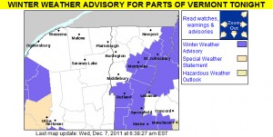
An map of the winter weather advisories in Vermont for October 27, 2011
October 27, 2011: Vermont's first winter weather advisories of the season

The National Weather Service Office in Burlington put up the first Winter Weather Advisory for the state of Vermont today, thanks to a storm that is passing to our south.  The southern and central parts of the state have been receiving the snow, with generally just clouds north of I-89.  The Killington area picked up a nice shot of snow; adk from Americanwx.com reported up to 14 inches of snow there in his post in the Northern New England thread.  You can find more about his trip at Famous Internet Skiers – they’ve got snowy skiing pictures from both October 27th, and October 28th.  The great news is that there may be another storm coming in on Saturday night to cover up all the tracks that people have been making and set us up for some great October skiing.

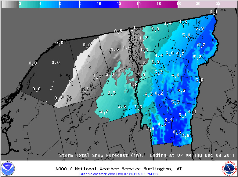
Snow accumulations map for October 27, 2011 from the National Weather Service Office in Burlington, Vermont
Snow accumulations with this storm have been in the southern and central parts of the state.

Accumulating snow today on Mt. Mansfied

An image of snow that has been accumulating at the snow measurement stake up near the top of Mt. Mansfield in Vermont
October 22, 2011: The fabled stake atop Mt. Mansfield, picking up the first accumulating snow for Vermont's Green Mountains this season

I was reading the Northern New England Thread on the New England Regional Forum at American Weather, and just got the word that Mt. Mansfield received its first accumulating snow of the season.  Thanks to Powderfreak for passing along the message, and including a picture of the snow at the Mt. Mansfield Stake, which I’ve included here.  As far as I’m aware, this is the first accumulating snow in the Green Mountains of Vermont this season due to the fairly warm October.  It does look like the weather is going to cool down this coming week, so there will likely be more chances for snow in the high country.  We’ll keep our eyes on the mountains, weather forecasts, and weather boards to see if any of the white stuff shows up in the near future, but as we approach November, the season of snow and skiing is certainly close at hand.

A touch of October snow for the Greens

With the warm weather regime we’ve been in over the past few weeks, it’s actually been a month since I’ve heard of any snow in the Green Mountains – September 16th was when we had that cold shot that produced some flakes.  We saw some frosty nights at the beginning of the month, but there was no precipitation with that cold air.  However, new reports of snow have been coming in today.  Over at the Americanwx.com New England regional forum, Powderfreak got a report of snow squalls atop Camel’s Hump, there was a report of various forms of mixed precipitation on Mt. Mansfield, and there was also a report of frozen precipitation from near the Pinkham Notch area over in New Hampshire.  Not surprisingly, Mt. Washington picked up some accumulating snow, with 1.2 inches reported for the day.

Another round of frost and freeze warnings for Vermont

The map of freeze warnings and frost advisories for October 5, 2011 from the National Weather Service Office in Burlington, Vermont
After our initial round of frosty weather back in mid September, more substantial freeze warnings and frost advisories are back for the start of October.

We’ve got another batch of cold air moving in over the next couple of days, so the National Weather Service Office in Burlington has put up freeze warnings throughout the area. Temperatures should be colder than last round with most areas in the 20s F, but since we’re into October now, that’s not all that surprising. For those areas like the Northeast Kingdom and the Adirondacks that don’t have warnings up, it’s because they aren’t needed; for those colder areas with early dates for the typical first frost, the growing season is considered to be over already. This is bad news for farmers in that area. Unfortunately, the weather cannot be changed. This will probably impact the crops of many farmers. To prevent this from happening next year, some farmers may want to take some extra precautions. Some may want to visit https://shrinkwrapcontainments.com/t-reinforcedblackout.aspx, for example, to purchase some light deprivation tarp. This is currently being used by full-time farmers in other areas who are trying to extend the growing season by creating artificial growing conditions. This tricks the crops, allowing them to continue growing for longer. Hopefully, this should help more farmers to have a successful growing season next year.

Some of the details from the National Weather Service have been added below:

434 AM EDT WED OCT 5 2011

…FREEZE WARNING IN EFFECT FROM MIDNIGHT TONIGHT TO 8 AM EDT THURSDAY…

THE NATIONAL WEATHER SERVICE IN BURLINGTON HAS ISSUED A FREEZE WARNING…WHICH IS IN EFFECT FROM MIDNIGHT TONIGHT TO 8 AM EDT THURSDAY.

* LOCATIONS…ALL OF VERMONT…EXCEPT CALEDONIA…ESSEX…GRAND ISLE AND ORLEANS COUNTIES. THE SAINT LAWRENCE VALLEY IN NORTHERN NEW YORK.

* HAZARDS…WIDESPREAD FROST AND BELOW FREEZING TEMPERATURES.

* TEMPERATURES…MAINLY IN THE MID TO UPPER 20S.

* TIMING…FROM AROUND MIDNIGHT TONIGHT THROUGH 8 AM EDT THURSDAY.

* IMPACTS…WIDESPREAD FREEZING TEMPERATURES WILL BRING AN END TO THE GROWING SEASON FOR ANY UNPROTECTED PLANTS OR VEGETATION.

A map of predicted low temperatures for October 5, 2011 for Vermont and Northern New York
Temperatures are expected to drop into the 20s F in much of the area this evening, resulting in frost and hard freezes for most locales.

First snow of the season for the mountains of Northern New England

An image of the fall season's first snow on Mt. Washington New Hampshire
As the afternoon wore on and the clouds dissipated, images from the Mt. Washington web cams began to reveal the white of fresh September rime and snow in the higher elevations

In association with our coldest weather of the season thus far, the mountains of Northern New England saw some snow today.  In Vermont, I heard about the frozen precipitation on Mt. Mansfield in a post from Powderfreak at Americanwx.com, and over in the Presidential Range of New Hampshire there were some visible accumulations above the 3,500’ to 4,000’ elevation level.  A great video from TheAutoRoad with scenes of snow falling along the Mt. Washington Auto Road was posted, and can be viewed below.  Even in the valleys the weather was quite cool today, with highs only in the 50s F, so the look and feel of fall was all around us.  Enjoy the video!

Frost and Freeze alerts posted for Vermont

The frost and freeze warnings map from the National Weather Service Office in Burlington Vermont for September 16th, 2011
Freeze Warnings and Frost Advisories have been posted for the entire state of Vermont.

The National Weather Service office in Burlington has posted a freeze warning for our area, and indeed the entire state of Vermont is under either freeze warnings or frost advisories, so cover up vegetation as necessary. This may also be a good time to look into local furnace maintenance services as you want to be sure your current furnace can meet the demands of this cold weather. Companies like CJS Heating offer such services. Why now? Well, furnaces have to work much harder when the weather is colder and so some may struggle to keep up. The last thing you’d want is for it to stop working whilst temperatures are so low. Though the first frost for valley locations in the Central and Northern Green Mountains does typically happen in September, the average date for the occurrence is toward the end of the month (September 27th for Morrisville and September 30th for Montpelier) so this is a bit on the earlier side. Yesterday in the Northern New England thread at Americanwx.com, Powderfreak posted the chart from the National Weather Service that shows the average dates and ranges for first frost at some of our Vermont climate locations – mid September is in the 10th – 25th percentile. Take a look at that post for more information about average dates of 32 F temperatures around the state.

A map of predicted low temperatures for Vermont and New York from the Natioanl Weather Service in Burlington for September 17th, 2011
Low temperatures are going to be down in the 20s F in some locations overnight as the first frosts and freezes hit the North Country of Vermont and New York.


Potential for a little September snow in the Northern Greens?

It’s that time of year again when we start to think more about the colder weather, and for the past few days our NWS point forecast for Waterbury has shown sub-freezing low temperatures at the end of the week.  Talk about the first snowfall of the upcoming season, has already begun – over in the New England forum at Americanwx.com, Dryslot pointed out the potential snow showers and frost in the forecast from the National Weather Service office in Portland, Maine.  This morning I saw that there is a cold weather update at the Famous Internet Skiers website, and on SkiVT-L, there was a visit from Roger Hill, who threw out the potential for a little snow accumulation at Jay Peak.  Although it doesn’t seem to be the case this time, I’m certainly reminded of a couple of seasons ago when some September snowfall actually produced enough snow to get in some skiing.  The past couple of days have been pleasantly summery, even up here in Northern Vermont, but it sounds like the crisp feel of autumn is on our doorstep.

2010-2011 Ski Season Summary

Having now compiled all our ski trip and winter storm summary reports for the ’10-’11 ski season, I’ve put together this season summary as a view of how things transpired from a Northern Vermont local perspective.  It’s interesting to note that for Burlington, winter ’10-‘11 was well above average for snowfall (128.4”, 175%), while out in the mountains at our house the deviation was much less (197”, 114%), and indeed in the higher elevations of the Northern Greens like Bolton it was even closer to average (330”, 106%), so ski resort snowfall around here was essentially average.  I actually made a chart for a post at Americanwx.com concerning the ’07-’08 season, which used Bolton’s snowfall from the past several seasons as a general indicator of how the snowfall has been in Northern Vermont:

A table showing the snowfall at Bolton Valley Ski Resort in Vermont from the 2006-2007 through to the 2010-2011 season

One can see from the chart that ’10-‘11 was basically average for snowfall, and that the amount of snow (330”) was identical to ’07-’08.  I would add that the general impression was that consistency of winter temperatures was a bit better than average in ’10-‘11 due to fewer warm events, so the quality of snow surfaces was higher.  I’m not sure how much better than average it was though, since it seems that during midwinter, the norm in the higher elevations of the Northern Greens is to have about one warm episode per month.  Also, since we were essentially out of the main track of synoptic storms until February, there wasn’t much in the way of moderate-density snowfall to resurface the slopes.  I try to address the consistency of temperatures/quality of the snow surfaces in the text below though, at least in the context of weekends; I should note that it’s possible there could have been some midweek weather issues that simply flew under the radar for me.  For the quality assessment I simply focused on whether or not we were skiing powder, because unless there is some sort of notable rise in temperatures, there is always powder available.

A monthly breakdown of snowfall and my perspective on the season follows below – you can click on each month (except November) and it should bring up that month’s posts in the J&E Productions Web Log.  I only have the monthly snowfall for my house and not the ski areas, but the percentages relative to average often parallel the mountains reasonably well, especially for Bolton which is right up above us:

October:  Pretty typical in that we got at least some snow for skiing; we had 1.0” of snow at the house.  October snowfall in the lower valleys is often minimal enough that the percentages aren’t all that relevant, but that number is 111% vs. the five year average since we’ve been at our house, so indeed that’s rather “normal”.

November:  Very poor; we got just 2.4” of snow at the house (29% of average) and I don’t really remember it, nor do I have any entries for that month in my ski log, so that says plenty right there.  I do have a vague recollection of storm after storm tracking to our north and west giving us mostly rain though, so that would explain the low snowfall total.  The lack of snowfall wasn’t necessarily a huge concern at the time since it was “only November”, but without good November snowfall, getting to appropriate base depths and excellent skiing in December can be that much harder.

December:  Quite normal, 46.0” of snow at the house (right about average at 102%).  Fortunately, even with minimal November snow we were skiing natural snow terrain by December 10th up at Bolton; the holiday period featured some decent skiing, with 7 outings for me during that stretch, indicating that the snow was obviously OK.  Bolton had picked up 4 feet of snow from the storm at the beginning of the month, however, a lot of that snow, as well as what fell later in the month, was upslope fluff.  So, even if one assumes a fairly average amount of snowfall for the mountains like we saw in the valley, the very dry nature of the snow meant that there was less liquid than usual, resulting in base depths that really didn’t build quickly.  The Boxing Day Storm was unfortunately the start of a pattern that would last the next five to six weeks, with the big synoptic storms staying well south of the region and pounding Southern New England, while northern areas remained on the fringe and essentially survived on fluff.  Temperature consistency/snow surface quality:  Skiing was done on all 4 weekends of the month, and out of the 12 outings in my records, the only outing without powder skiing was Friday, Dec 31st, so that suggests pretty consistent temperatures.

January:  We got 55.5” of snow at the house, which is above average (137%) in what can sometimes be a dry, midwinter month.  However, January was essentially a month-long continuation of the trend that started on Boxing Day, and we were living on mostly Northern Vermont Champlain Powder™ fluff.  We had a couple of good upslope storms in the early to mid part of the month (January 7th and January 12th) that made for some fine skiing, but obviously since so much of it was pixie dust, the base depths just could not build the way that they would with some synoptic storms.  Temperature consistency/snow surface quality:  Skiing was done on all 5 weekends of the month, and out of 11 outings in my records, the only outing without powder skiing was Saturday, Jan 1st due to the warmth at the end of December.  So I think one could argue that weekend ski surface consistency through Dec/Jan was better than average with only one (instead of two) weekend-affecting warm up(s) for the two months.

February:  This is when the storm track finally shifted north and we got some notable synoptic storms; the first one was right on the 1st, and then we had a second storm on the 5th.  That first storm brought just over a foot of snow for us down in the valley, and was by far the largest for the month.  Thus there weren’t really any mega dumps based on my records from the house, but there was plenty of the usual good skiing at Bolton and even good skiing at Stowe.  Snowfall was 48.1”, which is roughly average at 108%.  Temperature consistency/snow surface quality:  Out of the 10 outings in my records, all 10 of them had powder skiing, so February was perfect in that regard.  However, while skiing was done on all 4 weekends of the month, we had to wait until Monday of the long weekend to ski because there had been some sort of warm-up.  So I’d say the month was pretty typical with at least that one warm-up.

March:  We continued to stay in the storm track for most of March, with our biggest valley snowfall of the season (25.0”) coming from the March 5th storm.  We did wind up with notably above average snowfall in the valley for the month (39.6”; 155%), essentially due to that one big storm and aided by the fact that what I’ve got for a March average could be a bit low due to very poor Marches in ’09 (12.6”) and ’10 (2.1”).  Temperature consistency/snow surface quality:  Skiing was done on all 4 weekends of the month, and powder skiing was done on all those weekends, however, there was also notable infiltration of non-powder skiing days into the weekends.  Relative to the previous three months, only 9 of our 12 outings for March featured powder skiing, so while still a pretty good ratio, it was certainly a decrease.  Indeed there were multiple warm ups in the month because those three non-powder days were actually on three different weekends (the 1st, 3rd, and 4th weekends).  Fortunately, those weekends were somewhat redeemed by powder on the other day.  By March, especially toward the end, things may start to fall off a bit from the typical rate of one warm episode per month, but I would expect that with at least 3 individual warm ups in March, it was nothing great or even above average in terms of consistency.

April:  This was again quite a poor month in terms of snowfall and powder skiing; although snowfall correlation between our location down at the house and the mountains can really start to wane as one moves through April and snowfall becomes more and more elevation dependent.  Snowfall at the house was well below average for the month (4.4”; 61%).  We did at least start out the month with a snowstorm on the 1st and another one on the 4th; these events produced some good weekend powder skiing at Bolton and helped the mountain snowpack to surpass 100 inches at the Mt. Mansfield Stake.  However, the snowfall really fell off after that.  Temperature consistency/snow surface quality:  Skiing was done on all 5 weekends of the month, but only 3 out of 9 days had powder and only 2 of the weekends had powder skiing.  People were excited because we had a relatively deep snowpack during the month and coverage stayed longer than normal, but after that first week the storm track had shifted to the north/west and it was just storm after storm that featured warmth and little to no snow, even for the mountains.  I commented on that trend in a post at Americanwx.com, since there can easily be feet of snow in the higher elevations in April, and instead of just some corn days or spring crud, we could have been skiing some great powder.
May:  The May skiing was good due to the healthy snowpack, and I did get out in the powder on the 6th for top to bottom skiing on Mansfield.  We didn’t get any snowfall at the house during the month, but May’s average snowfall numbers down at our elevation are pretty minimal like October, and with the high sun angle and warming as we approach the solstice I suspect even more removed from correlation with what the mountains see.  Temperature consistency/snow surface quality:  I wouldn’t say May powder is consistent enough to worry about.  I only got out for two days during the month, but at least one was a powder day; the other day was a corn snow day at Bolton so that was also good even if there wasn’t fresh snow.

June:  Our only day in June was outside VT on the East Snowfields on Mt. Washington, and the snowfield was probably smaller than usual for that time of year due to the below average Mt. Washington snowfall for the season.  There actually had been some frozen precipitation in the northern mountains leading up to that day, but we were skiing corn snow.

So in terms of overall snowfall, the two above average months of January and March were basically counteracted by the two below average months of November and April, and with the rest of the months being about average, the snowfall for the season ends up… about average.  Some plusses were better than average snowpack in April and May, but that’s somewhat counteracted by the lower than average snowpack in November, December, and January.  It looks like there was an uptick in consistency in the December-January period due to just that one notable warm-up, but with February and March coming in probably about average in that category, and while November is not especially consistent in terms of temperatures, even in the higher elevations, it must have been below average to get so little snow for the month.  So taking the trends of consistency as an aggregate from November through April, I wouldn’t say that there was a massive improvement in temperature consistency/snow quality for this area.  Something that I have noticed around here is that having a few more storms with mixed precipitation is not necessarily a huge detractor in terms of snow quality.  The ’07-’08 season was a good example of this.  We were right in the storm track, so if we did receive some mixed precipitation, there was often another storm on its heels so quickly, that old snow surfaces were covered up.  It felt like we were right in the storm track for most of that winter, except that we had a relatively poor April with little snowfall (we picked up just 1.6” of snow at the house, even less than this past April).  It is interesting to note that winter ’07-’08 (consistently stormy from November through March) and winter ’10-’11 (biggest synoptic storms focused on just February and March) provide quite disparate examples of how to get to very similar seasonal snowfall totals (203.2” and 197.0” respectively at the house, and 330” and 330” respectively up on the mountain).

Tree skiing:  While working on some web page material, I came across the post I made about the average date for the start of Northern Vermont tree skiing, so I decided to add in the ’10-’11 data and see how the season compared.  In my initial analysis through the ’09-’10 season, the average start date for tree skiing was December 9th ± 13 days with an average of 28.2 ± 6.8 inches of snowpack at the Mt. Mansfield Stake.  In terms of my personal log of outings from last season, I’ve got a start date of December 18th, 2010 for tree skiing, and the addition of these data alters the averages very slightly, bringing the date one day later to December 10th ± 13 days, and the average snowpack down a tenth of an inch to 28.1 ± 6.5 inches.  So in terms of the ’10-’11 season, the start to tree skiing was slightly late in that it started about a week later than the mean date I’ve calculated.  With the horrible November in terms of snowfall, and much of the December snowfall being dry fluff, the late start is not too surprising.  However, the date is well within one standard deviation, so in that sense the start to tree skiing was another parameter of the season that was basically “average”.

On that temperature consistency/snow quality note, I was curious about the powder skiing we did throughout the season, so I checked my reports.  For the list of outings below, I placed a P whenever we were skiing powder, and put a red X if we weren’t, so it shows the pattern of when we did have powder, and when we did not.  Links to the text and pictures for all the individual reports are available below if people want more details about the depth/consistency of the snow, or one can also step through the J&E Productions web log, which has an entry for each outing.  It’s interesting to note that starting at the beginning of the season in October and continuing through to March 26th, there were only four days (December 31st at Bolton Valley, January 1st on the Bolton Valley Nordic/Backcountry Network, March 5th at Cochran’s, and March 20th at Stowe) where we weren’t skiing powder.  Strangely enough, I’ve never looked at a season in that way before, but it did give me an even greater appreciation for just how much powder there is to ski around here.  After March 26th, the powder skiing really trickled off this season, although there were still at least a few days in there.  I’m not sure how this season compares to others since I’ve never looked at one like this before, but I suspect most other “average” seasons would look similar for the way we ski, and with our pattern of skiing there might be similar patterns even in seasons that deviate more from average snowfall.

Stowe, VT, Saturday 16OCT10
Stowe, VT, Sunday 05DEC10
Bolton Valley, VT, Friday 10DEC10
Bolton Valley, VT, Saturday 11DEC10
Stowe, VT, Sunday 12DEC10
Bolton Valley, VT, Saturday 18DEC10
Bolton Valley, VT, Sunday 19DEC10
Bolton Valley, VT, Thursday 23DEC10
Bolton Valley, VT, Friday 24DEC10
Bolton Valley, VT, Monday 27DEC10
Bolton Valley, VT, Tuesday 28DEC10
Bolton Valley, VT, Thursday 30DEC10
X  Bolton Valley, VT, Friday 31DEC10
X  Bolton Valley Nordic & Backcountry, VT, Saturday 01JAN11
Bolton Valley, VT, Saturday 08JAN11
Bolton Valley Nordic & Backcountry, VT, Saturday 08JAN11
Stowe, VT, Sunday 09JAN11
Bolton Valley, VT, Thursday 13JAN11
Bolton Valley, VT, Saturday 15JAN11
Bolton Valley, VT, Sunday 16JAN11
Bolton Valley Nordic & Backcountry, VT, Monday 17JAN11
Bolton Valley Nordic & Backcountry, VT, Saturday 22JAN11
Bolton Valley, VT, Saturday 29JAN11
Stowe, VT, Sunday 30JAN11
Bolton Valley, VT, Thursday 03FEB11
Bolton Valley, VT, Saturday 05FEB11
Stowe, VT, Sunday 06FEB11
Bolton Valley, VT, Saturday 12FEB11
Stowe, VT, Sunday 13FEB11
Bolton Valley Nordic & Backcountry, VT, Monday 21FEB11
Bolton Valley, VT, Friday 25FEB11
Bolton Valley (Timberline), VT, Saturday 26FEB11
Bolton Valley, VT, Saturday 26FEB11
Stowe, VT, Sunday 27FEB11
X  Cochran’s, VT, Saturday 05MAR11
Bolton Valley, VT, Sunday 06MAR11
Bolton Valley, VT, Monday 07MAR11
Stowe, VT, Tuesday 08MAR11
Bolton Valley, VT, Saturday 12MAR11
Stowe, VT, Sunday 13MAR11
Monroe’s Sugarin’, Barton, VT, Saturday 19MAR11
X  Stowe, VT, Sunday 20MAR11
Bolton Valley, VT, Wednesday 23MAR11
Bolton Valley, VT, Friday 25MAR11
Bolton Valley, VT, Saturday 26MAR11
X  Stowe, VT, Sunday 27MAR11
P  Bolton Valley, VT, Saturday 02APR11
X  Stowe, VT, Sunday 03APR11
Bolton Valley, VT, Thursday 07APR11
X  Bolton Valley, VT, Saturday 09APR11
X  Stowe, VT, Sunday 10APR11
X  Bolton Valley, VT, Sunday 17APR11
X  Stowe, VT, Tuesday 19APR11
X  Sugarbush, VT, Friday 22APR11
Bolton Valley, VT, Saturday 23APR11
X  Bolton Valley, VT, Sunday 01MAY11
Stowe, VT, Friday 06MAY11
X  Mount Washington, NH, Saturday 04JUN11

So yeah, long story short, pretty average season in my book.  On that note, since we’ve been back from Montana, the only season we’ve had with substantial snowfall deviation from average for Northern Vermont was a negative one in ’09-’10 as I show in that table of Bolton Valley snowfall near the top of the post.  There definitely hasn’t been anything like what many parts of the Western U.S. saw last season, but as I look at the list of outings above there’s still been plenty of great skiing.

Ty to appear in Bolton Valley ad in Kids Vermont

An image of Ty in the powder that we took back on our December 20th, 2008 ski outing at Bolton Valley will be appearing in an advertisement for the resort in an upcoming issue of the Kids Vermont newspaper.  I’ve attached a copy of the ad below; congratulations Ty!

Advertisement for Bolton Valley Resort 2011-2012
An upcoming ad for Bolton Valley Resort in Vermont to appear in Vermont Kids Newspaper

Ty also appears in one of the interior shots in this year’s brochure from Bolton Valley, promoting powder skiing & kids, so when Powderfreak commented over in the Ski Thread in the New England Regional Forum at American Weather, I added a response and posted a scanned copy of that material.  That image is below:

An image of Ty skiing deep powder at Bolton Valley Ski Resort in Vermont as part of their brochure promoting kids and powder skiing
In their brochure this season, Bolton used an image of Ty while promoting their kid-friendly atmosphere and great powder skiing.