We had our first reported snow of the season here in Vermont over a month ago when flakes were spotted atop Jay Peak, but this latest round of winter weather has now brought us the first actual accumulations of the season. Our initial images of the accumulations came out yesterday morning when Powderfreak sent out some shots from the higher elevations of Mt. Mansfield during his usual Stowe Mountain Resort duties. Later in the day he sent along a nice image of the cloud ceiling and flakes falling on Spruce Peak while he was out on an afternoon hike. The snow was down to at least the 3,100’ elevation as of the afternoon, and with more moisture pushing into the spine of the Greens according to the radar, the potential for some additional overnight accumulations was looking good. The moisture seemed to be drifting a bit south though, and I saw a comment from Powderfreak that he felt the Central and Southern Greens would have the better chances for accumulations during the overnight period.
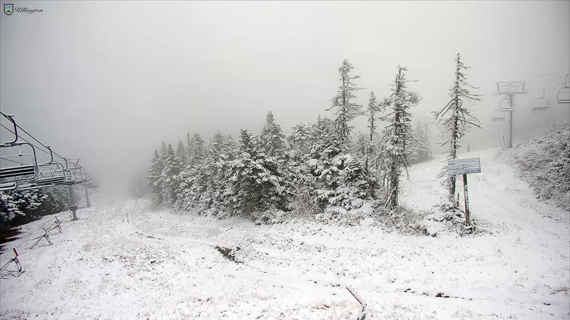
A shot from Killington’s North Ridge Webcam of today’s new snow during our period of first snow accumulations for the 2024-2025 winter season. Accumulations began in the area yesterday and the Central Green Mountain s picked up some of the best snows overnight.
AS OF 454 AM EDT THURSDAY…HIGH PRESSURE WILL CREST OVER THE REGION TONIGHT. GIVEN CLEAR SKIES AND NEALY CALM WINDS WILL ALLOW FOR IDEAL CONDITIONS FOR RADIATIONAL COOLING…WITH TEMPERATURES FALLING INTO THE 30S IN MOST LOCATIONS…WITH SOME TEMPERATURES APPROACHING NEAR RECORD LOWS FOR SEPTEMBER 6TH. EXPECTING TEMPERATURES TO FALL INTO THE UPPER 20S IN THE SHELTERED VALLEYS OF MOST OF THE ADIRONDACKS LATE TONIGHT. THUS…HAVE PUT OUT A FREEZE WARNING FOR THOSE AREAS. ELSEWHERE…HAVE PUT UP A FROST ADVISORY FOR MOST OF THE REMAINDER OF NORTHERN NEW YORK…AS WELL AS NORTH CENTRAL AND NORTHEAST VERMONT FOR PATCHY FROST. NOT EXPECTING ANY FROST OVER THE CHAMPLAIN VALLEY AS LAKE CHAMPLAIN WATER TEMPERATURES STILL IN THE LOW 70S…WHICH WILL KEEP THE VALLEY RELATIVELY WARM WITH MOST TEMPERATURES IN THE UPPER 30S IN THE CHAMPLAIN VALLEY.
“Depths of powder above whatever firmer subsurface lay below were in the 8-12″ range, with a bit of that melt layer in there in the lower elevations or on south facing terrain.”
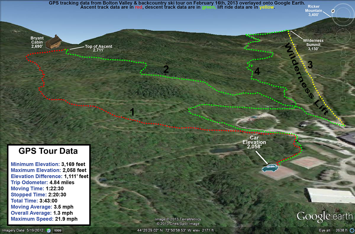
I devised a somewhat ambitious tour for today, at least with respect to what the boys might be willing to accommodate. It would be an opportunity to show E and the boys the two glades that I discovered last month on the 19th and the 27th. The plan was to skin up Bryant to the Bryant Cabin, descend through the first glade, then connect over to the alpine trail network, catch an assist from the Wilderness Lift to the Wilderness Summit, traverse out on Heavenly Highway, ski the second glade, and return to the car via the Nordic/backcountry network. If we couldn’t complete the whole tour we’d have some opportunities to truncate it as needed. The forecast called for some sun and temperatures in the 20s F today, so it looked like we wouldn’t have to worry about anyone getting cold too quickly.
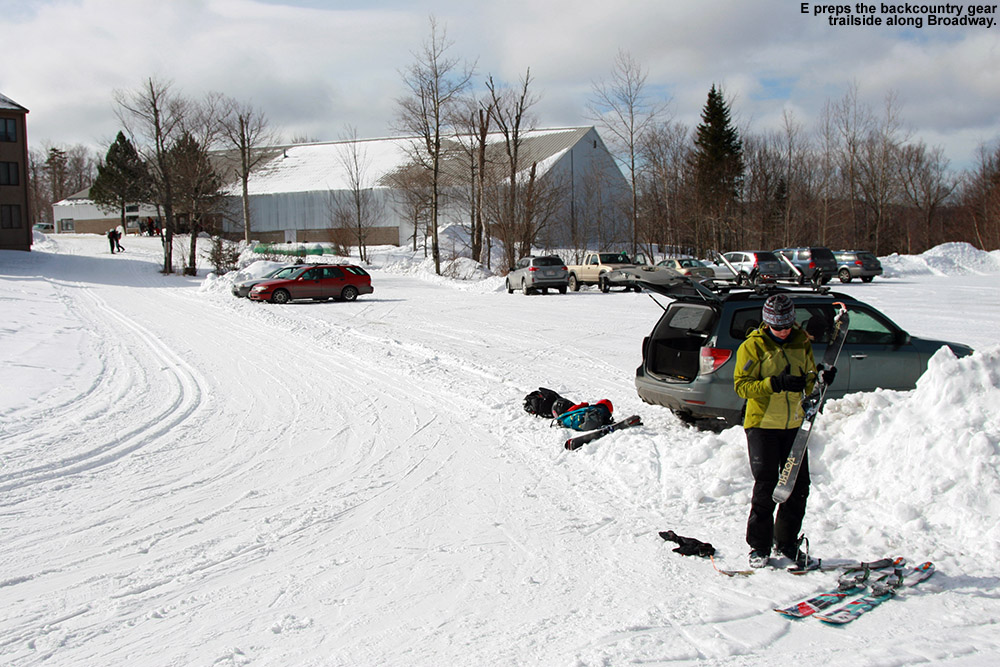
Unloading and preparing the gear along Broadway
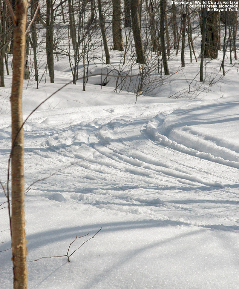
We arrived up in the Bolton Valley Village in the late morning period, and the main parking lots were getting pretty full, but we were able to get a trailside spot right on World Cup in the lower tennis court lot. There were plenty of people about as we began our ascent, including a number participating in the “Bolton to the Barns” event. We ran into Alex, one of my former students on his descent with the event group, and learned that he is now at Tufts Medical School, although he seemed very happy to be back in Vermont visiting Bolton Valley. Dylan asked for just one break on the ascent, and we pulled over into the sunshine along the top section of World Cup and had a snack.
Admiring the beautiful conditions in the World Cup Nordic trail as we pause for a snack on our way up to Bryant Cabin
Near the start of our tour when we’d passed by the Courtside 1 Condos on Broadway, we ran into a Nordic skier who was pausing there. She inquired about the substantial width of E’s fat skis, and E indicated that they were for powder skiing. The woman seemed puzzled because as far as she could tell there was no powder around. She wished us luck on finding powder, but you could tell she figured it was a lost cause. It was very interesting to hear her speak that way when just a few feet away from her off the side of the trail, you could see the powder sitting there. People certainly have some unique perspectives on snow conditions. As a Nordic skier, perhaps she’s got a totally different idea of what powder snow actually is, or she may have just been oblivious to what conditions were like off the groomed runs of the Nordic trails. Anyway, in terms of the actual snow conditions, out near the car a bit above the 2,000′ mark there were 2 to 3 inches of fluffy snow above a bit of a melt/sun crust, but I suspected that crust would disappear as we got out of exposed areas and headed up in elevation. Indeed, pretty quickly in shaded areas I found that the powder was deeper and the melt crust underneath was disappearing, and after a few hundred feet of ascent it was essentially gone. Depths of powder above whatever firmer subsurface lay below were in the 8-12″ range, with a bit of that melt layer in there in the lower elevations or on south facing terrain.
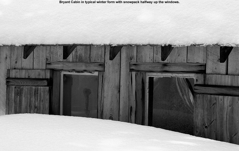
Snowy Bryant Cabin
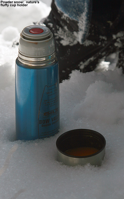
We found the Bryant Cabin in use with the woodstove pushing a fragrant plume of smoke out the chimney. When we talked to one of the guys using the cabin, he said that the resort is no longer renting it or regulating the usage; you can just use it on a first come, first serve basis. I’m guessing that also means that they aren’t supplying wood, which is why we frequently saw him browsing around for dead stuff to throw on the fire. Some people may have loved the idea of this, and have wondered if they should get a prefab log cabin of their own. For us, it was a place to rest for a bit. We sat down and had lunch off to the side of the cabin clearing, and enjoyed hot soup, cocoa, and other items we’d brought. Various groups of skiers made their way past while we were there; it was probably one of the busier days I’ve seen out there on the backcountry network, and it was nice that all the people were out supporting the use of the trail system. Hopefully the initiative to buy the land with the help of Vermont Land Trust will go through and people will be able to continue enjoying it as public land.
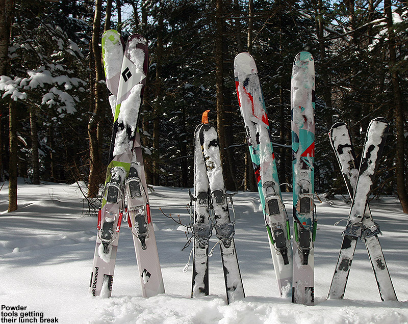
The Tele powder boards hanging out at lunch
“We found the Bryant Cabin
in use with the woodstove
pushing a fragrant plume
of smoke out the chimney.”
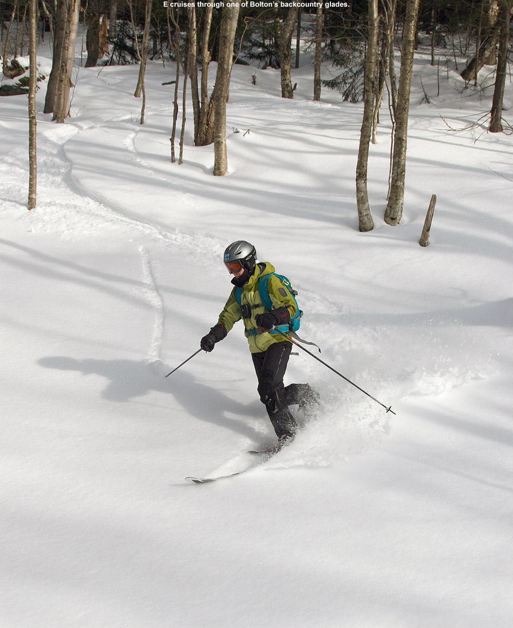
Our first descent was in the North Slope and Gardiner’s Lane areas, and the powder was very good in the upper elevations. On our first pitch dropping from North Slope, conditions were just right so that both Ty and Dylan made some nice Telemark turns. Later, Ty dropped a nice Telemark-style jump turn launching off one of the steeper pitches, and he was very proud of that. The boys threw in a good amount of alpine turns, especially when they wanted to go faster, but it was all around great practice for them. Like I’d noticed on our ascent, the last couple hundred vertical of the descent featured some of that melt crust below the powder. We were on a south-facing slope, so that certainly wasn’t surprising. I found my fat AMPerages to be really helpful in that terrain, and E had some nice turns on her Elements, but she’s still finding them hard to get up on edge in packed snow due to their width. We’re wondering if the play in her boots is just too much and it’s ruining the ability to convey the necessary pressure into the ski.
We connected over to the Wilderness Double Chair and took it to the Wilderness Summit as planned, but Ty was pretty insistent on a quick descent without additional skinning. So instead of heading across on Heavenly Highway to drop through the second glade I’d chosen for the day, we opted to descend on Peggy Dow’s to quickly get to Snow Hole. There was decent powder in Snow Hole, although it was certainly more tracked and packed than what we’d seen in the backcountry glades. I got off to the sides of the main route a good deal though and got a number of fresh lines, and at times the boys would follow me. We did make a good connection back onto the Nordic network and caught a few final turns on the Telemark Practice Slope and other lower mountain glade areas before heading back to the car. We’ll be planning another tour at some point to catch that second glade; I still want to show it to E and the boys.
A map of today’s combined alpine, Nordic, and backcountry tour at Bolton Valley – click for full-size image
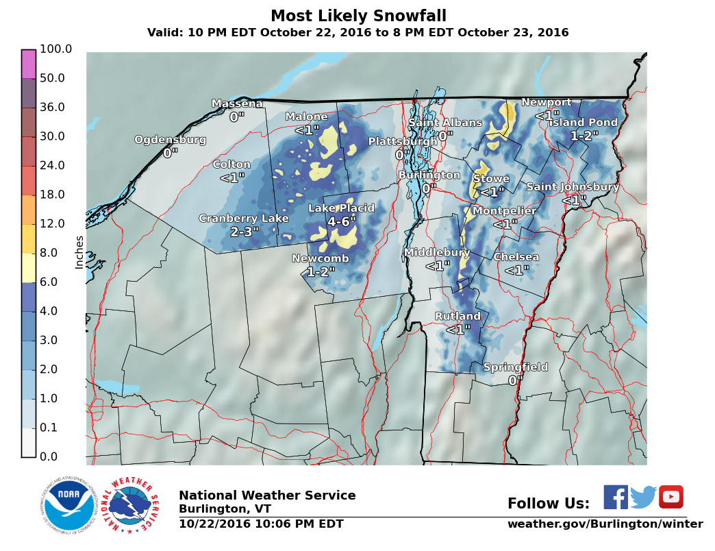
Our next shot at snow appears to be coming into the area in the Tuesday timeframe. It looks like it’s going to be a pretty standard frontal passage at face value without much fanfare in terms of snowfall, but there is definitely the potential for some upslope snow. The crew at the National Weather Service Office in Burlington has had their eyes on the potential, and Powderfreak has been watching as well. We’re hoping for that snowfall boost from the upslope snow, because there isn’t much forecast in terms of synoptic snowstorms in the immediate future.
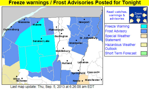
Freeze Warnings and Frost Advisories are up throughout much of the state of Vermont tonight.
Parts of the Northeast have had bouts of sub-freezing temperatures since the end of August, but tonight looks like the first widespread occurrence of the season throughout Vermont. We’ve got a frost advisory here in Washington County, but it sounds like some of the colder areas of the state up in the Northeast Kingdom could get down into the middle 20s F, and freeze warnings are in place. It’s certainly time to cover up those gardens in the usual cold spots.
Sub-freezing temperatures are forecast for much of Vermont tonight.
Freeze Warnings and Frost Advisories have been posted for the entire state of Vermont.
The National Weather Service office in Burlington has posted a freeze warning for our area, and indeed the entire state of Vermont is under either freeze warnings or frost advisories, so cover up vegetation as necessary. This may also be a good time to look into local furnace maintenance services as you want to be sure your current furnace can meet the demands of this cold weather. Companies like CJS Heating offer such services. Why now? Well, furnaces have to work much harder when the weather is colder and so some may struggle to keep up. The last thing you’d want is for it to stop working whilst temperatures are so low. Though the first frost for valley locations in the Central and Northern Green Mountains does typically happen in September, the average date for the occurrence is toward the end of the month (September 27th for Morrisville and September 30th for Montpelier) so this is a bit on the earlier side. Yesterday in the Northern New England thread at Americanwx.com, Powderfreak posted the chart from the National Weather Service that shows the average dates and ranges for first frost at some of our Vermont climate locations – mid September is in the 10th – 25th percentile. Take a look at that post for more information about average dates of 32 F temperatures around the state.
Low temperatures are going to be down in the 20s F in some locations overnight as the first frosts and freezes hit the North Country of Vermont and New York.


