Vermont Maple Open House Weekend

Don’t forget, it’s the official Vermont Maple Open House Weekend, so try to support your local sugarhouse at one of the open house events.  We’re planning to head to my cousin Steve’s operation in Barton for their open house.  When he called me earlier in the week he said to make sure everyone brought snowshoes because the snowpack is pretty hefty as usual.  I think we’re also going to bring Tele gear and do a tour as long as the snow softens up appropriately for turns.  With last year’s low snowfall, touring around had a bit of a different feel because there was only a bit of snow left and it was like a spring hike.  His snowpack is often much more substantial than ours though, so if things are typical up there the skiing could be nice.  Checking my records, it looks like our 2008 visit was at the tail end of March and yielded some very nice turns.

Next chances for snow coming in: Thursday through Sunday

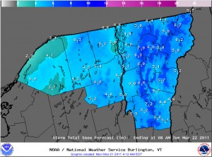
It looks like the next snow event in our area is on tap for tomorrow, with low pressure tracking into Southern New England. Checking in on the discussion from the National Weather Service office in Burlington, the snow level is expected to rise to the 1,500’ to 2,000’ range, with mixed snow and rain below that. The point forecast for our elevation in the Winooski Valley at ~500’ suggests 1 to 3 inches of snow in the Wednesday timeframe, with a bit more possible on Wednesday and Thursday nights. In his broadcast this morning, Roger Hill was suggesting the potential for a couple of inches of snow tomorrow morning affecting the commute. Point forecasts for the higher elevations to our north have 2 to 4 inches in the Wednesday timeframe, and farther to the south, 3 to 5 inches is coming up where the NWS says a good combination of the surface track placement and 500 to 700 mb lift get together. After that, the next storm is expected to come into the area Thursday, and provide precipitation chances through Sunday. It’s another warm system, but there will be chances for snow, especially in the higher elevations.

Wet snow falling in the valley this morning

Snowfall and new snow on the playset out back
When I woke up, wet snow was falling and new snow was accumulating on the playset out back.

I woke up to find wet snow falling here at the house. I’ve added an image of the new snow from out back, and the Intellicast colored radar image as well. Full details are in my morning report to the NNE thread at Americanwx.com.

Northeast Intellicast colored radar for the morning of March 13th
Snow heading into the Northern Vermont area this morning on the Intellicast colored radar

Bolton Valley, VT 12MAR2011

Tracks in the Villager Trees
There was some decent powder in the Villager Trees

I headed up to Bolton Valley today to catch some afternoon turns, and the sking was pretty nice. There were a couple of fresh inches, and conditions varied from wintry up top with the surfaces helped out by the new powder, to borderline spring-like down low with the surfaces helped out by the warmer temperatures. The powder off piste was certainly vairable, but there were nice turns depending on elevation and aspect.  More details and images are in my Bolton Valley, VT 12MAR2011 report.

Dylan in the powder on the Stowe website

Dylan skiing powder at Stowe
Dylan ripping up the powder in Stowe's Nastar Hill/Meadows area

One of the pictures from our Tuesday visit to Stowe was added to the photo gallery on their website: it’s Dylan ripping up the powder in the Nastar Hill/Meadows area. Way to go Dylan! You can click on the image here to see it full size, there’s another version available in Stowe’s Gallery, or you can find it by browsing the gallery.