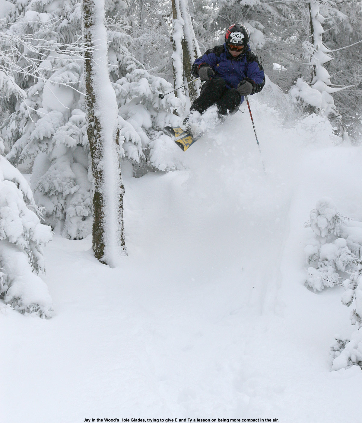
Jay enjoys some deep snow in Bolton Valley's glades today.
After Tuesday’s great outing with the boys, the whole family headed out for more turns today. The skies had been somewhat gray on yesterday, but the sun was back today and consistent with the forecast trends, the temperatures were climbing to the low 30s F.
There hadn’t been any new snow, so we didn’t find ourselves out to the slopes until midday, but the Timberline area still seemed to be following the trends I’ve seen over the week and most visitors were presumably over at the main mountain. We kicked things off on Spell Binder, and the most obvious change in on piste conditions from Tuesday was that the powder and chowder had been replaced by packed powder. I found that there was still powder to be had if I went very tight to the edge of the trail, but it had to be helmet-scraping tight.
We then headed off to the trees for a bit to get in some powder skiing – E had gone with alpine skis for the day so that we could explore some steeper lines and see how they were faring. Our first test was the steep terrain dropping into the KP glades, which revealed that tight evergreens at around the 2,000’ elevation had still not seen enough snow to support much traffic or aggressive skiing. The evergreens had not allowed enough snow to fall to the forest floor, but the mixed evergreen/hardwood glades below were in prime form and yielding great untracked turns. To check out the rest of the details and see all the pictures from today, head to the full December 30th, 2010 trip report from Bolton Valley.
A quiet scene with untracked powder at Bolton Valley's Wilderness area
The boys opened up some early Christmas presents today, so there was no way I was getting them up to the hill, but I was able to join up with Stephen and his kids for some turns. In the past we’ve had some great Bolton outings on Christmas Eve, with some nice natural snow terrain available and the mountain almost to ourselves. However, due to the sizeable amount of visitors we’d seen yesterday, we were wondering what today would bring. Would more people have the day off, or would that be counteracted by more holiday obligations? Well, the visitors were back in a big way, apparently even bigger than what we’d seen yesterday. On the way up to the main base, I stopped in for a look at Timberline, and it looked quite ready for the planned Sunday opening.
Conditions were very similar to yesterday, and a bit of wind had actually reset some of the powder to provide repeat fresh tracks. The wind also put down some wind crust, but it was pretty weak and didn’t change the snow too much. The weather and snow were both great, but with the lines and afternoon holiday obligations were all left around noontime. On the way down the road I saw that two Timberline lots were being used for additional parking, so business was certainly good. To check out all the pictures with the text, head to the complete Bolton Valley report from today.
Erica checks out the latest round of powder at Bolton Valley today.
We contemplated heading to Smuggler’s Notch today to use some free vouchers, but opted for Bolton Valley instead when they won out with snow accumulations. Bolton reported 7 inches of new snow, and based on my analyses from the house, it was in the 8-9% H2O range for density. This meant that the powder wasn’t as fluffy as what we skied over the past couple of weekends, but it definitely put down some substance in the snowpack. We picked up more than a third of an inch of liquid equivalent in our snow down at the house, so Bolton probably had twice that amount.
We joined up with Stephen, Helena, and Johannes and hit our usual favorite areas for powder. With the composition of the group we didn’t spend too much time in the trees, but occasional jaunts I’d make into the woods revealed that there was awesome tree skiing to be had. Since many places were already skiing pretty well over the weekend, the bolus of new denser snow definitely bumped it up another notch. Overall the snow was awesome as usual, and the sides of the lesser used trails were holding enough powder that heading into the trees wasn’t really necessary to get great turns. To see all the pictures and get the rest of the details, head to the full report from Bolton Valley today.
Glorious powder was found on Spell Binder up at Bolton Valley today.
We had a busy day of holiday-related activities planned today, so I headed out early to earn some powder turns up at Bolton Valley before things got going. Although I’d been hearing great things about the snow at Timberline, and I’d driven by and seen the tracks there a number of times, I decided it was finally time to check out just what all the fuss was about. Indeed, as I found out, the quality of the powder there is in fact worthy of a fuss. To see all the powdery details and images, go to the full Bolton Valley trip report from today.
Some nice powder turns were made at Bolton Valley this morning.
This morning I headed up to Bolton to catch some opening day turns and check out the four feet of new snow they’d picked up over the week. On the way up I could see that Timberline was just loaded with tracks from all the folks that had been earning turns there. We’d had our coldest temperatures of the season this morning, and although it was still somewhere in the single digits when I arrived at the mountain, the wind was calm and it turned out to be very comfortable.
They had the usual early season options going, but also some natural snow terrain such as the lower part of Wilderness. I saw that VT 200 was open at the top, but it still looked somewhat bony. I found that Wilderness and the routes over there were the places to be though, one could get some nice steeper turns in about a foot or so of powder in the junction areas of Swing, Lower Crossover, and Work Road, and then down on the Wilderness lift line it was mellow powder cruising. To check out the rest of the details and see all the pictures from the day, head to the full Bolton Valley Trip Report from today.
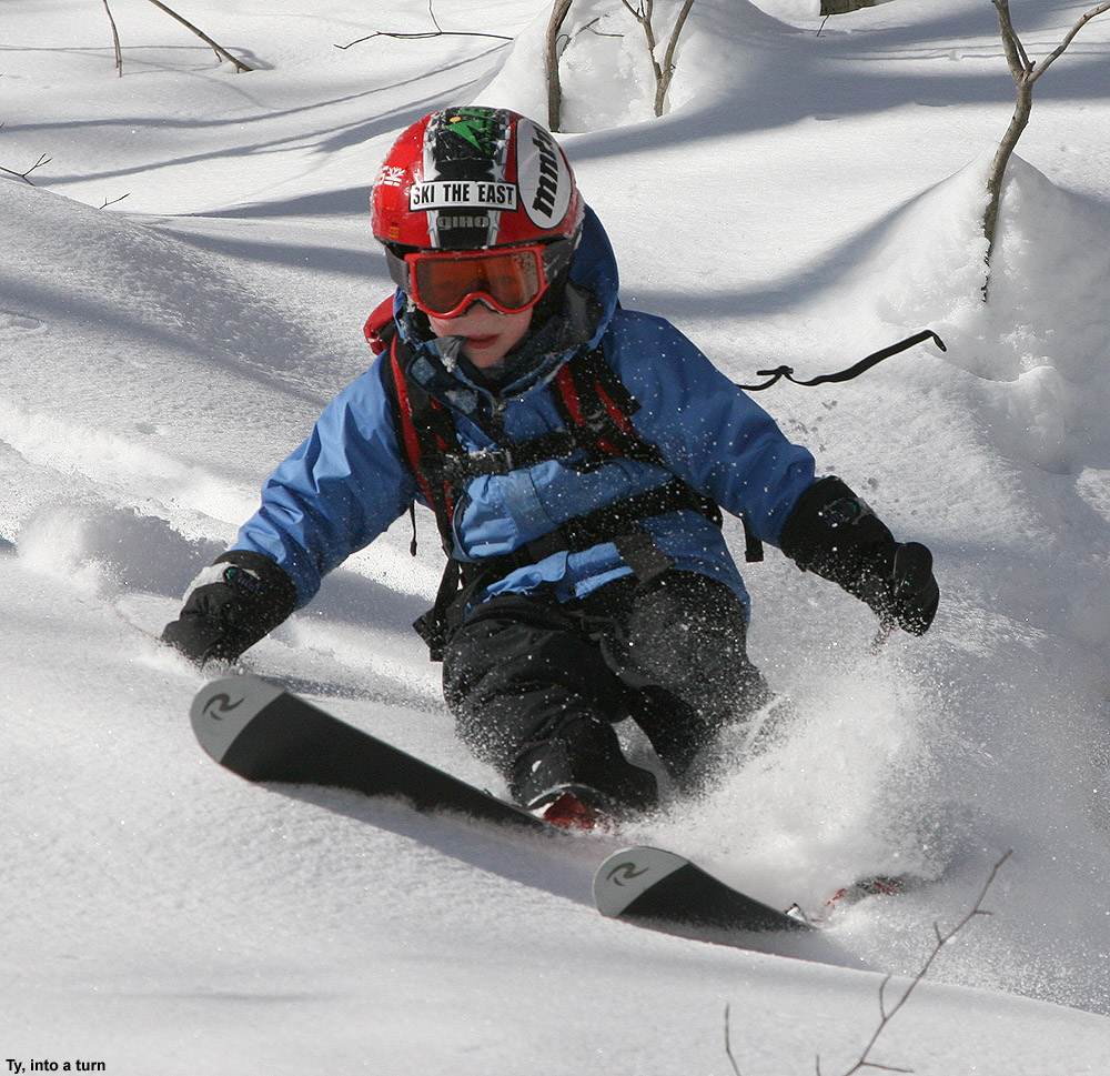
Ty out there ripping up some of the powder on Bald Hill today
Saturday was another potentially good day for some backcountry skiing in Northern/Central Vermont, since snowfall had again been rather minimal in the area during the preceding week. At the house in Waterbury, we’d picked up just 1.4 inches of snow in the Sunday/Monday range from a storm that favored parts of Maine and Southern New Hampshire with up to a foot, and then 1.6 inches of snow in the Tuesday/Wednesday timeframe from an upper level low coming out of the Great Lakes. As for the mountains, I saw accumulations topping out in the 4 to 5 inch range for the Bolton through Sugarbush stretch, with amounts tapering off to the north. The forecast on Saturday called for a cold start in the 0 F range, but brilliant sunshine and eventual temperatures in the 20s F. Weather wise, it was an excellent time to get outside.
“The combination of settling and the thin breakable crust in some spots made things tricky at times, but it was all soft and fun.”
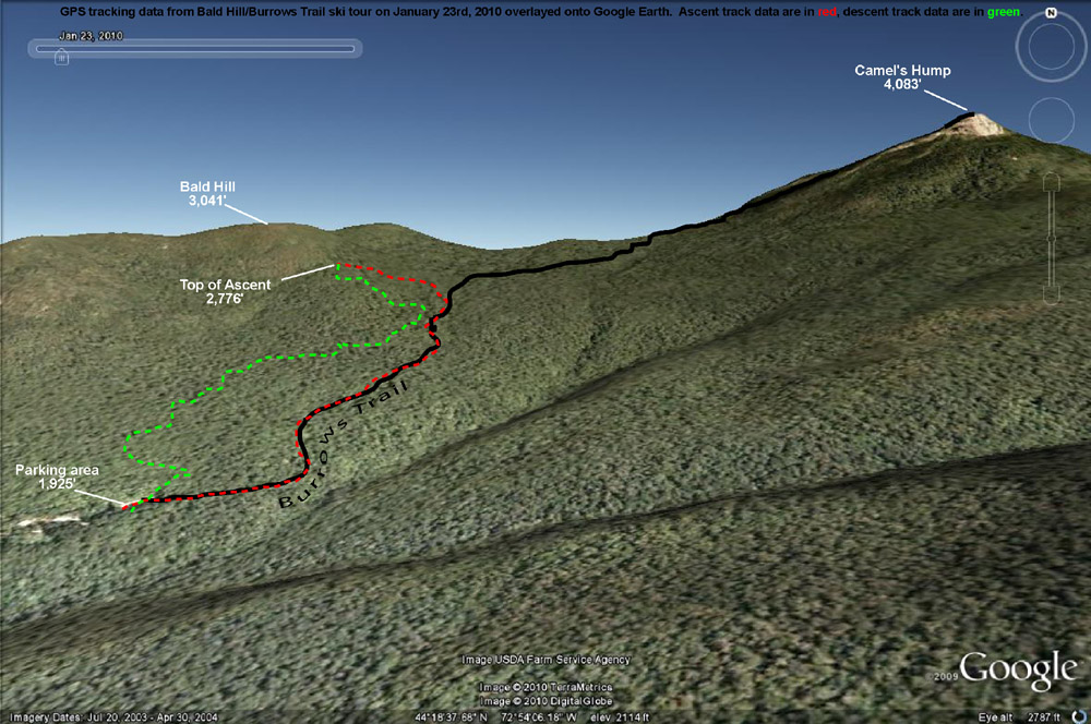
With the snowfall thoughts in mind, the plan was to do some skiing off the west side of the Camel’s Hump/Mt. Ethan Allen area. Unfortunately, on Friday we found out that Tom had tweaked his knee and ankle at soccer, so the ski group for the day was going to be just James, Ty, and myself. We met up with James in Huntington Center a bit after 9:00 A.M., and decided on an initial plan of heading up the Forest City Trail to do some skiing on the lower flanks of Mt. Ethan Allen (3,674’), the next prominent peak south of Camel’s Hump. We headed up Camel’s Hump Road, finding that the access to the Forest City trailhead was going to be difficult because the road there wasn’t plowed in the winter. There was a little room along the snowbank to potentially park a couple of cars, but a more important factor in our case was the added distance to get to the trailhead. Ty’s backcountry range is not that great yet, so we weren’t looking for a big approach. There was the option to connect over to the Forest City Trail from the Burrows Trailhead area, but we decided to just do something simple off the Burrows Trail. James had commented to me earlier that there was going to be a temperature inversion in effect, and that was indeed what we saw on our ascent of Camel’s Hump Road. From down in Huntington Center (690’) where the temperature was somewhere in the middle single digits, the temperature was up around 10-11 F at the trailhead parking area (~1,900’). The lot was about half full, and while we geared up, we could see that several parties of people were heading out for hikes on snowshoes.
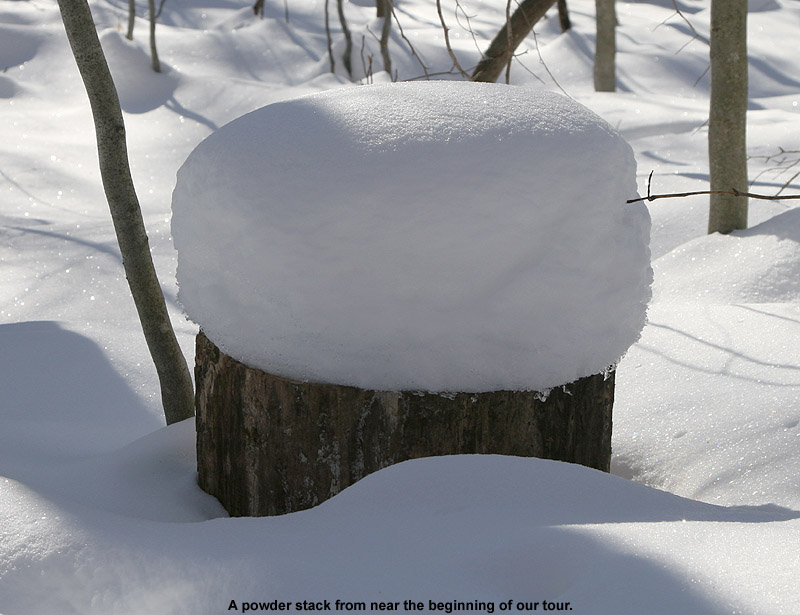
Some of the powder stacked along the Burrows Trail
Starting up on the Burrows Trail, I checked the snowpack and found a couple inches of fluff on top of a generally thin crust, atop a lot more settled powder. A few of the lower elevation stream crossings on the trail were open with small gaps, and that represented a bit of a challenge for Ty, but he managed well. We didn’t have any lofty goals in mind other than getting in a little skiing, since our ultimate destination would likely be affected by Ty’s mood and stamina. Our pace was pretty slow with Ty taking his time, but it was an easy go, and everyone’s skins were working well on the packed trail. There were lots of dogs, lots of people on snowshoes (including a bigger group that seemed to be from the UVM Outing Club), and we also saw a party of about four skiers that passed us on their way up the trail. One of the more interesting sights was a woman coming down trail at breakneck speed on a sled that looked like a booster seat. We made sure to move out of her way, but she seemed to be very conscious of the uphill traffic and stopped easily. James inquired about how her sled worked, and she demonstrated that for braking, you just lean back. I know that people like to use those Mad River Rocket-style sleds on the trail and elsewhere, but this was the first time I’d seen what this woman had.
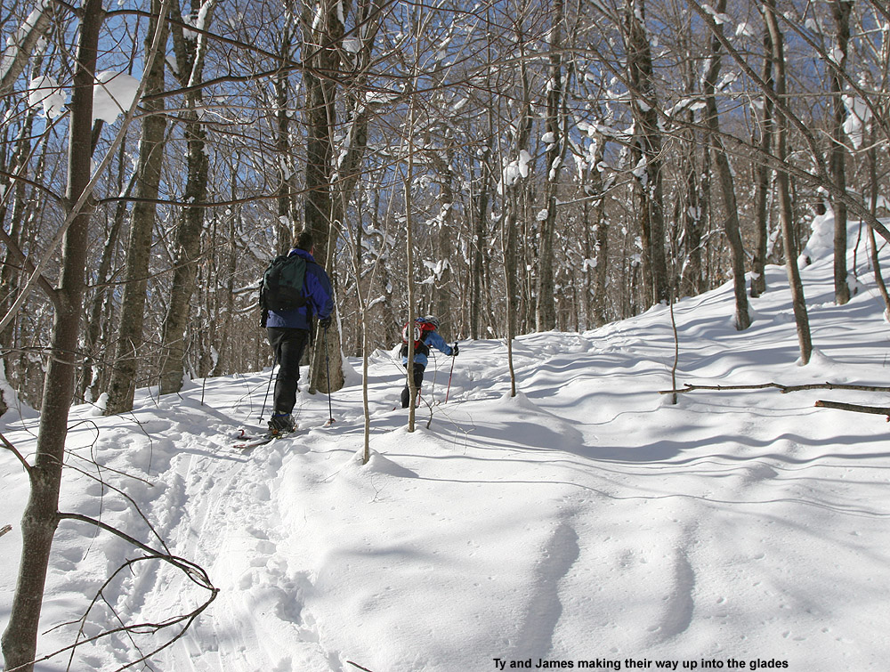
Ty and James ascend Bald Hill.
Up to about the 2,300’ elevation mark the surrounding vegetation was on the brushy side, but above that point it began to thin out and the potential for skiable lines looked a little better. Off to our right, we could see some open, moderate angle slopes across the big gully that had begun to parallel the trail, and off to the left we could see the more obvious lines that steepened on the way up to Bald Hill (3,041’). Ty had some good bursts of skinning speed when we kept him motivated, but as inquiries about how far we were going and when we would get to ski became more frequent, we decided it was time to think about our descent route. Heading off to the left for the lower slopes of Bald Hill was going to make things easiest for getting back to the trailhead for Ty, so a bit above 2,500’ when we hit one of the skin tracks breaking off the Burrows Trail and going in that direction, we took it. The change of scene was enough to keep Ty motivated for a little bit longer, since we were able to tell him that we’d be able to descend soon.
We headed up into the glades a little farther, reaching an elevation of about 2,700’ before Ty seemed to be getting just a bit too antsy. There were plenty of good lines available with untracked snow, but we could see that taking them would mean dropping right back down to the Burrows Trail almost immediately. So, we continued to contour westward to get something that might drop a little more directly to the trailhead. We could only traverse so far though, since Ty knew we were close to skiing and his inquiries started up again. When we finally called it on the traverse, James and I skinned up a little farther to catch a nice looking line, while Ty waited just below us.
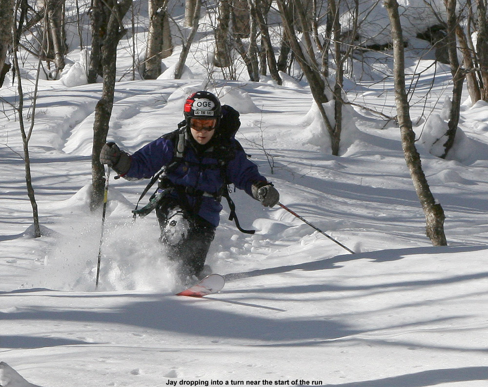
Jay enjoys some turns in the beautiful powder out there on Bald Hill.
The skiing was good, and definitely worth the hike, but certainly not perfect or quite up to what I’d found off the Monroe Trail the previous weekend. The combination of settling and the thin breakable crust in some spots made things tricky at times, but it was all soft and fun. Ty stuck with just alpine turns, but had a lot of fun catching air and working on his jumping technique. Our extra traversing had bought us a little longer descent, but we still dropped back to the Burrows Trail pretty quickly. Instead of trying to ski on and near the trail, we took a traverse out to the west with the aim of eventually dropping back down to the parking lot to finish our run. I used the GPS for route finding, and as is often the case, James went by his natural sense of direction. The biggest issue with the traverse was that like on the Burrows Trail itself, a few streams were still open from the previous warm weather. They weren’t too hard to cross since there were still snow bridges around, but Ty’s smaller skis definitely set him at a disadvantage for spanning some gaps. We helped him across when needed. Even with the aid of the GPS, I overshot the parking area by about 100 feet or so and had to swing back during my final descent, while James nailed it right on.
The GPS tracking data from today’s ski tour plotted on Google Earth
Views of the glades along the Monroe Trail on Camel’s Hump
From what I’d been hearing, ski conditions were generally decent around the area this week, but new snowfall was sparse. Subsequent to the 9 inches of snow that Bolton picked up last weekend, they’d only reported 2 to 3 inches of additional accumulation. Down at the house in Waterbury (495’), we picked up 4.8 inches of snow from that weekend event, and then smaller events on Monday and Wednesday dropped 1.2 inches each. It was enough to keep things fresh, but it was rather dry snow that probably didn’t add too much new substance to the snowpack.
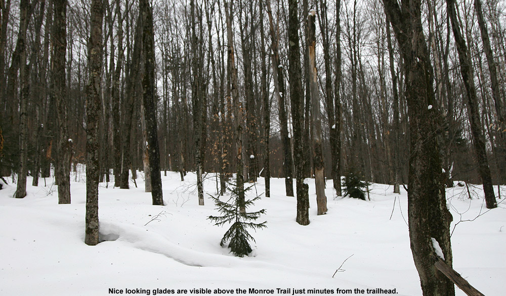
The end of the week also saw an increase in temperatures, with our location in the valley getting up to around 40 F at times. It was a little hard to get a sense of what had gone on with the weather in the mountains, since I heard talk of a crust in the Mt. Mansfield area, but Paul Terwilliger’s report from Central Vermont suggested that the powder was great down there. Unsure of whether I was going to encounter, powder, crust, mush, or who knows what, I chose to keep it simple and earn some turns close to home. I decided to check out some terrain right across the Winooski in North Duxbury below Camel’s Hump. From the Winooski Valley, at an elevation of about 400’ or so, the Camel’s Hump Road heads southward up into the mountains for several miles to an elevation of about 1,500’ where there is access to Camel’s Hump State Park and various hiking trails. My friend Weston used to live right up near the top of the road, and told me that there were plenty of glades up above him along the route to Camel’s Hump. I took a peek at my copy of David Goodman’s backcountry skiing book for Vermont, and he also speaks of the various glade skiing options along the Monroe Trail.
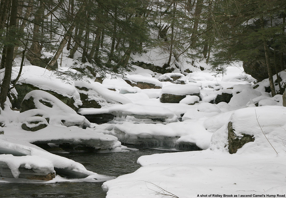
This was actually my first time driving up Camel’s Hump Road in the winter, so it was neat to get the perspective with the snow. The drive offered great views of Ridley Brook, which flows near the road throughout the drive. I always get a kick out of some of the funky houses along the road: some that seem to be accessed by unique bridges, and others with their own quirks, like one that seems to be some sort of partially underground structure with a flat roof. At this time of the year, the very top part of the road is closed, so I had to park in the winter parking area at ~1,200’. From a temperature of ~38-39 F down at the house, the temperature dropped to ~36 F at the parking area, and in terms of snow conditions, I hoped that the temperature would continue to drop as I ascended.
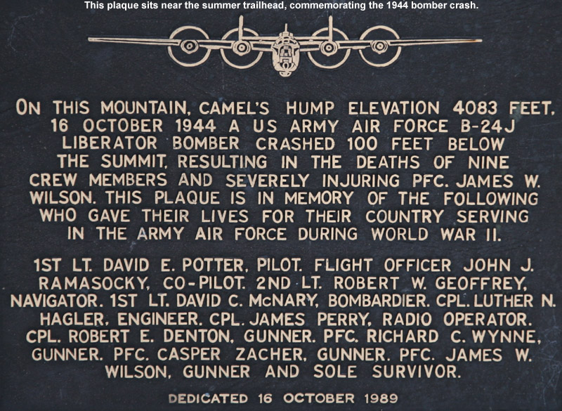
With skins on, I quickly made it up the rest of the snow-covered road to the main parking area and trailhead at around 1,500’. I checked out the plaque near the trailhead commemorating the 1944 bomber crash on the mountain, and then I was on my way up the trail. I began checking the consistency of the snow, and it seemed like the powder was dense, but not really wet, and there was no detectable crust. Within a few minutes of being on the Monroe Trail, I began to see obvious glades up above me as Weston had suggested. The Monroe Trail didn’t really attack the fall line, instead it seemed to gradually contour up and to the left in a southwesterly direction. I figured that one approach to skiing the glades would be to see if I could gain some elevation on the Monroe Trail and eventually traverse back in a northeasterly direction for a fall-line style descent back to the trail, but I wanted to see where the Monroe Trail would take me on its own before I started breaking snow on a new route. The trail was well packed, and plenty wide as David Goodman suggests in his book, so it’s really easy to cruise along with skins. I was happy to have full-width skins in a few spots where the trail gets steep, but one could certainly make due with less as long as the snow consistency supported good grip. There were a few ski tracks where skiers had come out of some of the glades, and tracks suggested that a few more folks seemed to have skied on and around the trail, but I didn’t see any skiers during my tour. I did see a lot of people on snowshoes: one group of 6 to 8 people, a few couples, and a couple of other groups.
The trail continued it’s mostly gradual, southwesterly ascent, and at around 1,800’ I noticed that the trees seemed to have more brush in them than I’d seen in the earlier part of the climb. At 2,300’ in elevation, I reached the junction of the Monroe and Dean Trails, and direction-wise, continuing on the Monroe Trail was the obvious choice for what I wanted to ski. The Monroe Trail had been starting to wrap around toward a more northwesterly direction, getting more in line with my efforts to eventually head to the northeast, while the Dean Trail headed southwest. Not far above the junction, the forest began to turn into a beautiful combination of birches and evergreens, and I could see some nice ski lines for folks that opted for the skiing in the trail area. Then, a little above the 2,500’ elevation mark, I hit the frost line and everything began to turn white, changing the look of things again. Ascending farther, the forest transformed back into more hardwoods again with some decent open ski lines paralleling the trail, and I could see that a few people had used them. Finally, as I approached the 2,800’ level, the trail was actually starting to almost make a north/northeasterly jog and far above I could see huge cliffs on the eastern face of Camel’s Hump directly ahead of me. The forest quickly transformed yet again into an area of almost exclusively evergreens.
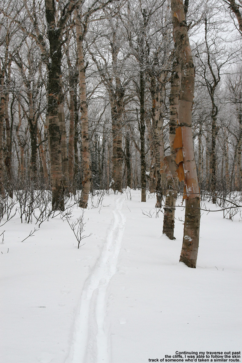
Traversing through the higher elevations of Camel’s Hump
It was after 3:00 P.M. by that point, and as I didn’t want to push the available daylight, I began to look for the best route to traverse northeastward for my descent. I followed the Monroe Trail for as far as it seemed to jive with my plan, and when it really seemed to head southward I had to begin my traverse. I traversed north/northeastward among the evergreens, and down below the cliffs the trees were often quite open. If the snow was elevation-dependent, or if one wanted to simply stick in this terrain, I could easily see this area being used for some great laps of skiing. Indeed, I saw various tracks of previous skiers scattered around, suggest that folks had had some fun. As I made my traverse through the evergreen forest, I came across various tracks of people that had either been descending or ascending, but I eventually picked up a skin track that seemed to be very much in line with my plan. I followed the track through the evergreens until it broke back out into a lot of birches, crossing what looked like an interesting trail marked with blue flagging tape. That blue-flagged route looked intriguing, but it ran literally perpendicular to where I wanted to go, so I had to pass it by and chock it up to future exploration. I checked several times with my GPS compass to ensure that the track I was following was legitimate, and not something left over by somebody that had simply been lost, but it stayed on course.
After another couple of minutes of traveling through some flat, very open terrain, I noticed that the skier/rider before me had started to make a couple of turns, so I decided it was time to take of my skins and focus on the descent. I was excited about the skiing prospects, even if only due to the snow depths and consistency I’d see on the ascent. I had little idea about what I might find for slope continuity or vegetation below. In terms of snow quality, there had been no sign of a crust aside from a couple of isolated spots that had a thin coating that must have been from the sun. And, throughout the trip I’d been checking on snow depths, finding anywhere from 14 to 26 inches of settled powder atop the base snow.
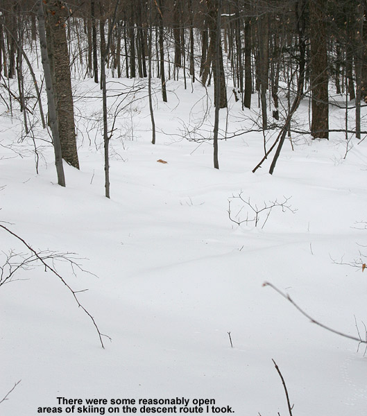
Some of the ski terrain out there on the tour today
You don’t always know quite how snow is going to ski until you actually get on it, but as soon as I dropped that first knee into a turn all questions were answered. The powder was dense as expected, and I was only sinking in about 4 to 5 inches, but the density made the turns really smooth. I continued on with turns, checking my GPS every couple hundred vertical or so to ensure that I was on track to hit the glades near the start of the Monroe Trail. There were some steeper options off to my left (north) but with the tree spacing they would be best for deeper/lighter powder. I found the conditions perfect for the moderate and low angle slopes that I encountered. Ultimately, my descent was not as fall line as I was initially hoping for, and I really had to keep pulling left throughout the descent to stay on target, but I was pretty happy with it for a first shot. I occasionally saw a couple of other tracks in the area as our paths crisscrossed, so obviously some others (presumably at least that track I’d followed) had done something similar. As far as tree spacing went, it wasn’t a brush-fest, and there were a few more open areas, but nothing extraordinary relative to what I’ve seen around here for what appears to be nature taking its typical course. If one didn’t have to check on or correct their route, most competent tree skiers could enjoy a fairly continuous ride without having to constantly hit the brakes for brush. A couple more feet of base would help a little on the bush front, but not too much from what I could see, and it’s certainly not needed in terms of coverage. With the base snow plus all the settled powder, coverage was absolutely bomber on everything I found on my ascent. I was able to pop off small boulders etc. and never heard a thing from my skis. The most consistently open glades on my descent were the terrain I’d seen down near the Monroe Trail, and I actually still came up just shy of one of the shots I’d been aiming for. Looking at my GPS/Google Earth plot, I can see that a longer traverse up high would be needed for a more direct fall line descent, but that’s something to strive for in a future trip. It does remind me of a quote from David Goodman’s chapter on the Monroe Trail, where he says “The quest for the perfect glade run will keep you coming back to Camel’s Hump time and again…”
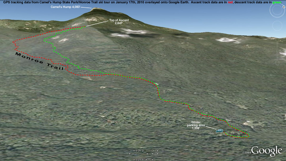
The GPS track of today’s tour on Camel’s Hump in the Monroe Trail area plotted on Google Earth
So, both the base and ski conditions in the Monroe Trail section of Camel’s Hump State Park were great as of yesterday at all elevations I skied off piste (1,500’ – 2,800’). We picked up 1.4 inches of snow from last night’s activity, so that area should have picked up something in the 1 to 3 inch range as well, and I can’t imagine that would be anything but a positive on top of the conditions I experienced.
Looking down Stowe's Hayride ski trail at the fresh October snow and brilliant fall foliage
For quite a while, the local weather gurus had been talking about the potential for local snow at the end of September/beginning of October. Yesterday, reports started coming in of white in the mountains, and from UVM I could see the tendrils of snowfall crashing out along the Green Mountain spine. It was looking like this morning would feature some real accumulations of snow, but yesterday evening the snowfall seemed to come to a halt. I started to reconsider my thoughts of taking a morning trip up to Mt. Mansfield, but sometime after dark I checked the local radar and it looked like snowfall was blooming again. I awoke this morning to see that there were still echoes on the radar, the temperature at the house was ~41 F, and our back deck was wet. I suspected there had been some additional snow on Mansfield, so I hopped in the car and decided that I’d at least go for a hike before work.
While I couldn’t see much white at all on my drive to the mountain, as I finally got close to Mt. Mansfield, I could see that there was a good covering of snow from about the middle elevations of Spruce Peak on up. I parked in the upper lot of the gondola (~1,600’) and there were a half dozen cars that looked like they could belong to other early morning folks checking out the snow. Snow was falling all around me, and while it wasn’t sticking at the base, I could see white on the ground not far above. At some point after 7:30 A.M., I strapped my skis on my pack and headed up Nosedive, hitting the snow line right around 1,800’. The depth of the snow didn’t increase too quickly, only up to maybe ½ to 1 inch in depth by the 2,000’ mark. I thought that the snow would probably be great for the junkboarders, but I wasn’t quite sure about those who were on regular skis. Not long after I had that thought though, I met three skiers coming down Nosedive, right around the intersection with National. They clearly seemed to be making due on regular skis and seemed to be enjoying it. During my ascent it snowed most of the time, and occasionally the snow came down with moderate to heavy intensity. Being starved for a bit of winter weather, I loved it.
Even by the top of Nosedive (~3,600’) the snow was only up to about 3 inches in depth, but I hiked on a bit farther to check out the Mt. Mansfield Stake. There was some vegetation in front of the stake (~3,700’) that hadn’t let the snow settle all the way to the ground, but the depth of the snow was clearly less than 6 inches. At least one vehicle had driven on the Toll Road, but I still popped on my old Telemark skis and did a little gliding in the untouched snow outside the tire tracks. That was quite pleasant, although due to the minimal snowfall, there was the occasional crunch of a piece of gravel. Not wanting to deal with the hassle of negotiating the steep terrain of Nosedive with somewhat minimal snow, I continued on the Toll Road and into the Ridge View area before deciding to take off my skis. I had even made a few Tele turns on the snowy grass, but by around the 3,000’ elevation, a combination of wanting to head back in the direction of the Gondola via steeper terrain, and not wanting to put any real damage into my skis saw me strapping them back on my pack. I’m not totally ready to commit the Hellgates to official rock ski status just yet.
Hiking up had been really enjoyable (I think it was the first time I’d hiked such a long distance in Tele boots without switching to skinning) but the vistas on the descent were spectacular. With the dramatic scenes of white surrounding me, and the brilliant colors in the valley, I stopped frequently to pull out the camera. My descent was somewhat meandering, taking me down through the Hayride and Lookout areas, before making it down to Crossover and down to the gondola lot. The snow level on Mansfield looked like it had crept up a few hundred feet since my ascent, so it was certainly warming up. Insofar as I can recall, I think today’s outing was the first time that things came together to allow me to ski on my birthday, so that made it even more of a treat that usual. To check out all the pictures from the day, head to the Stowe trip report from today.
Today you just aired it out wherever you wanted… it didn’t matter.
E and the boys are off from school this week, so I joined them for a day up on the mountain yesterday. Heading up to ski was pretty much a no brainer – it looked to be almost a carbon copy of Saturday, with another foot or so of upslope Champlain Powder™ overnight to finish off another three-foot storm cycle, and the clouds pulling away to leave blue skies and perfect temperatures. Bolton Valley had just finished off a run featuring six feet of snow in six days, which doesn’t happen all that often… anywhere.
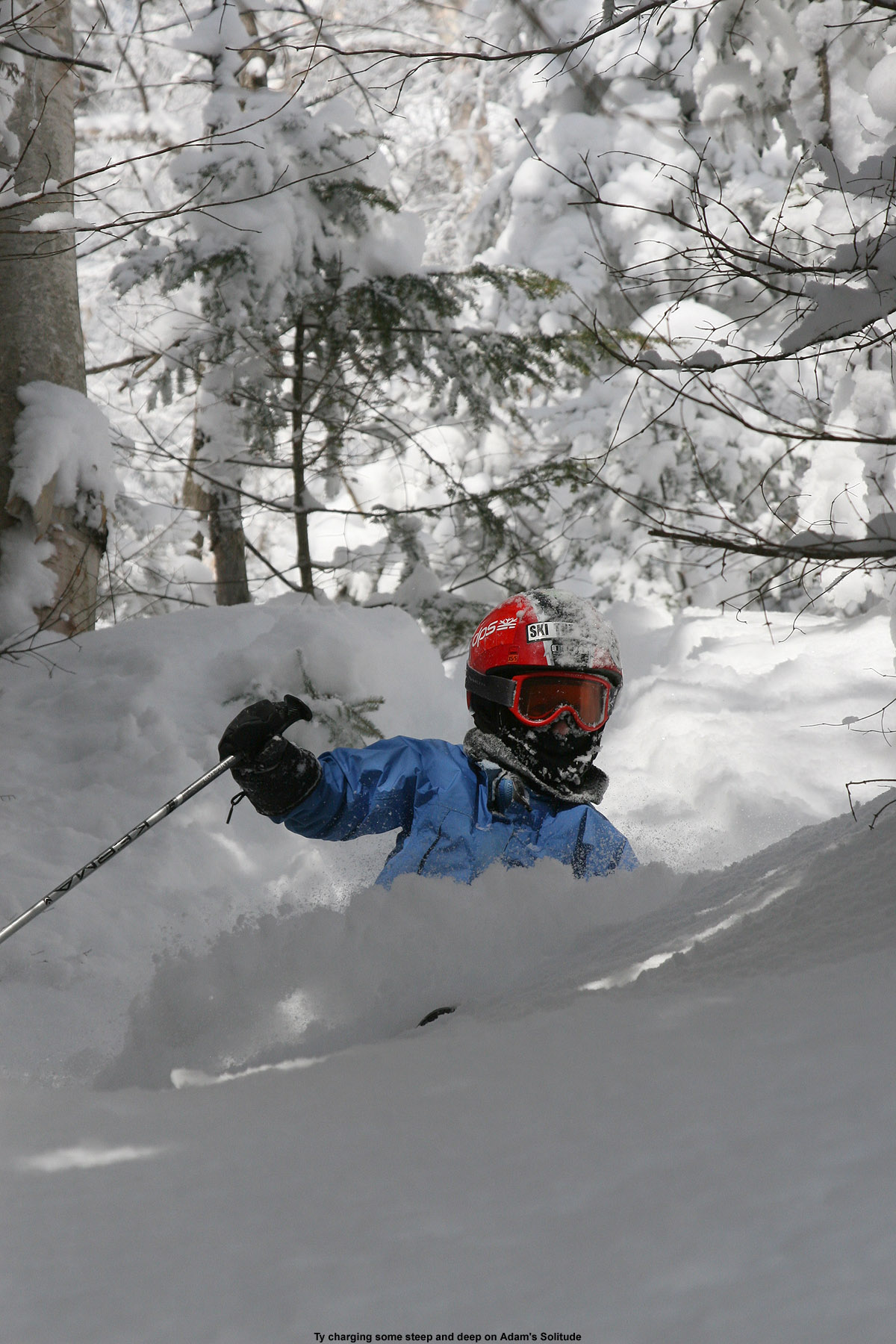
We hit up many of our usual haunts in the Timberline area, but also got in a few runs in the Adam’s Solitude/Wild Woods out of bounds areas, which we’d yet to visit this season. I don’t visit those areas all that often, but I was absolutely floored by how protected the accumulated snow was over there. Amazingly delicate accumulations of Northern Vermont’s famed upslope snow had settled on everything, apparently defying gravity by even accumulating laterally and growing off the sides of trees. All it seemed to take was the slightest imperfection on a surface to catch a few crystals, and then they would apparently grab hands and just go nuts. I’m not sure if the area is always protected like that, but I’ll sure be on the lookout with future storms. My final overnight accumulation of snow down at the house for that event had come in at 2.4% H2O, which is not all that uncommon for upslope snow in our sheltered valley location, but there really were areas up near the top of Adam’s Solitude where the snow was like air. I’d be skiing along through the usual bottomless powder and I’d hit pockets where it would feel like the bottom had literally dropped out because the snow became so airy. It almost felt like I was hitting small tree wells, but it was just the settling pattern of the powder. Anyway, it was quite an experience. I’ve skied a lot of cold smoke snow between Vermont and our years out in Montana, and yesterday snow now sets the standard. I can remember a day at Smugg’s several years back that featured snow as airy as yesterday’s, but it was only about 6 to 12 inches deep and not bottomless, so the experience wasn’t quite the same.
Ty out there on Adam’s Solitude getting a taste of that Champlain Powder today
I wanted to bring E and the boys over to explore some areas on the main mountain, but the day at Timberline was so packed full of runs that we just never had the chance to get over there. We did manage to meet up with Stephen and his kids for a final run down Adam’s Solitude. It was a first time out there for them, so it was quite an introduction to that terrain. I worked a bit with Ty and E on getting their body positioning more compact when they are in the air. They’ve still got some work to do, but it was one of those days where you didn’t mind having to try, try again on those kinds of tasks. The rest of the images from yesterday can be found below in the gallery, and full size versions are also available in our report to SkiVT-L.
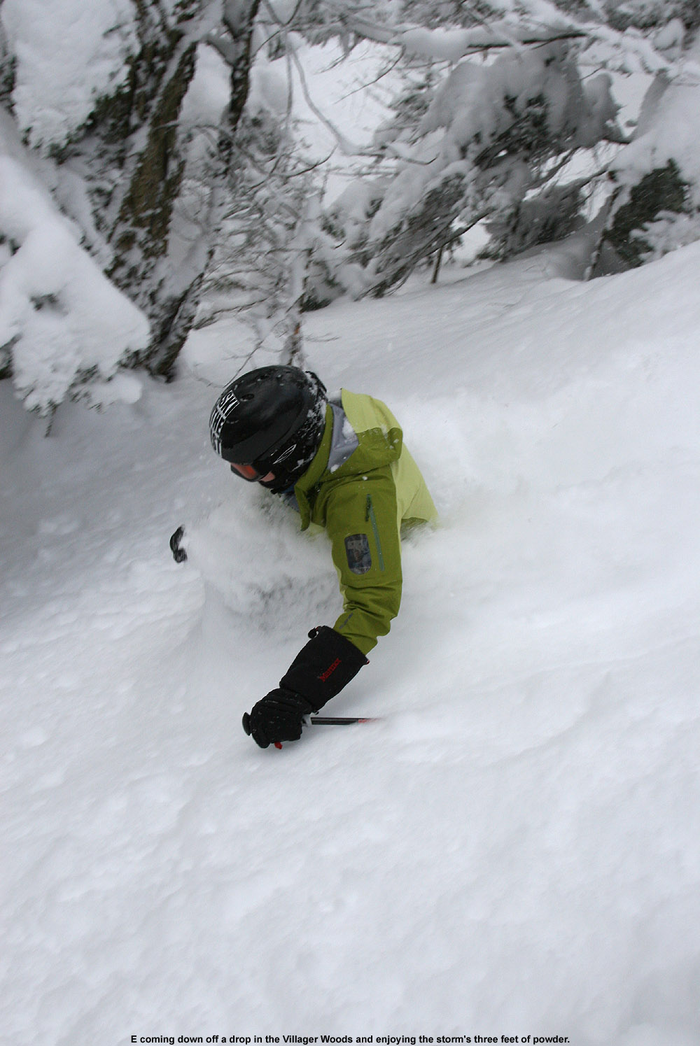
As E demonstrates, today was one of those day when you could go neck deep… if you’re into that sort of thing.
The numbers are in, and they indicate that Bolton Valley picked up a solid three feet of snow from our latest storm cycle, with the final 12 inches of upslope fluff coming in overnight to set the table for a fantastic Saturday. The day started off a little cloudy and breezy, but by midday we were left with warm sunshine to make for one of the best ski days of the season. We arrived up at the Timberline Quad for the 8:30 A.M. opening, and in classic Bolton Valley style the powder day lineup was comprised of a whopping three chairs worth of people. The first hour or two of the morning were pretty quiet in the Timberline area, at least in terms of numbers of visitors, although generally not in the voices of those of us that were there. By 10:00 or 11:00 A.M. more visitors started to arrive.
“The deep powder also let Ty engage in his own personal huck fest ’09.”
While the trails only contained about a foot of powder in areas that had seen skier traffic over the past couple of days, many off piste locations that hadn’t seen visitors on Thursday or Friday held the entirety of the storm in and undisturbed stack. Before heading up to the mountain this morning we joked about losing Dylan in the deep snow, but fortunately that didn’t happen. The good thing about the snow was that it was quite dry (my analysis on the overnight accumulation at the house was 3.7% H2O); even the boys could get down in it and really have a fun time experiencing the depth. We met up with Dave and his friend Jo at 10:00 A.M., and my colleague Stephen and his son Johannes early in the afternoon, and all eight of us managed to do a couple of great runs on Twice as Nice together.
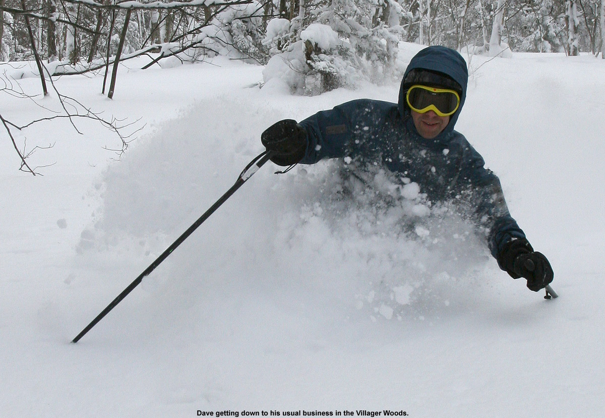
Dave stopped in today for some of his usual Bolton Valley activities
For Ty it was a day of notable improvements in his skiing. With the fantastic depths of powder in the off piste, he was able to start charging steep slopes more aggressively than I’ve seen up to this point. E and I had indicated to both boys that they would want to ski steeper terrain than usual today because the deep powder would be slowing them down. They weren’t very receptive to this idea at first. However, by the end of the day Ty had really changed his tune and was actually seeking out some of the steepest lines so he could tackle them. Dylan had quickly picked up on the idea as well.
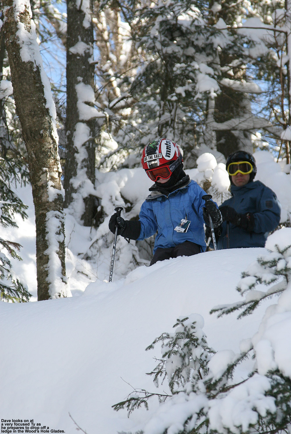
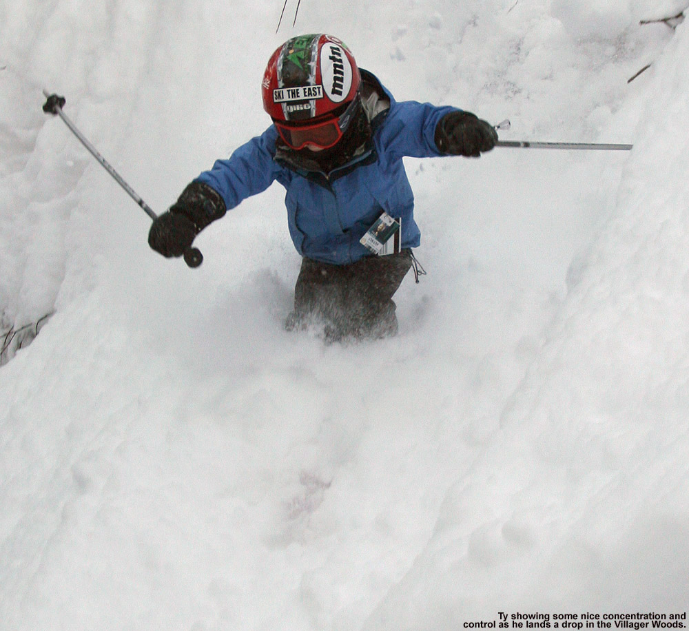
Peering over the steep edge of a drop… decisions, decisions.
The deep powder also let Ty engage in his own personal huck fest ’09. I’d been saving up a nice 5 to 10 foot drop with a sloped landing that Dave and I had discovered in the Villager Trees a couple weeks back, and with feet of new powder it was ready to be plundered again. Ty likes to do jumps on his skis, but this type of a drop was in a league he’d never really tackled before, so I was curious to see his reaction. When we arrived at the top of the drop, he was certainly intimidated by the height and confirmed that he didn’t want to hit it. We didn’t want to force him, but we had Mom drop it and demonstrate how easy it was with such deep powder. After seeing that, he didn’t immediately change his tune, but we could see that the wheels were turning. Later in the day we were in the Wood’s Hole Glades and Ty somehow found himself atop a rather big rock. He dropped a pretty rugged looking line, and with that his confidence was building. I asked him if he’d be interested in joining Dave and I in dropping another small cliff on the next run and he said yes. We gave him first shot at the drop in the freshest powder, while E shot pictures from below. He wasn’t willing to carry a lot speed going into it, but he dropped right off and did an awesome job. At the end of the day when we were in the lodge, he indicated that he wanted to go out for one more run. He insisted that we hit the first drop that we’d shown him earlier in the day, the one that Mom had done. He said he was now ready for it. He had no trepidation this time around, and dropped it as soon as I was in position with the camera and gave him the go ahead. When we got back to the lodge he even told E that he’d done a better job on it than she had.
Those landings from the drops started to get smoother and smoother today for Ty
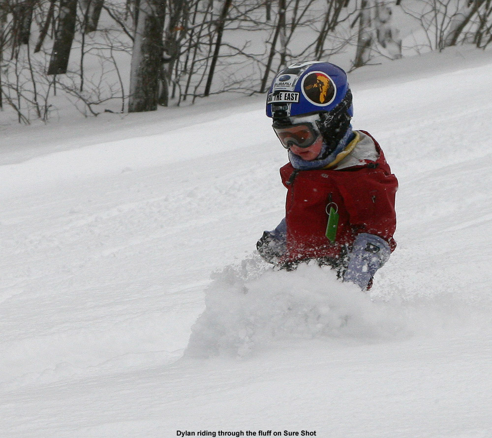
Dylan also had quite a day, blasting lots of powder lines with the most consistency that I’ve seen from him all year. He plowed through every mellow or steep nook and cranny that we dragged him into, and his powder skiing is now becoming reliable enough that we don’t have to worry much about bringing him into any of the typical areas that we’d ski as a family. It appears as though a mounting topic with Dylan is the use of ski poles. Ty didn’t start using poles until his 4/5-year old season (last year), but it looks like Dylan is about ready. After I broke a wayward stick off of a tree today in the Wood’s Hole Glades, Dylan proceeded to bring it with him for the rest of the run and use as a pole. Back on the trail, E told Dylan how he should be using the stick in terms of planting, and he easily coordinated the timing of planting and turning. We may have to start phasing in poles for him the way we did with Ty. Dylan also skied what was perhaps his biggest day to date, racking up over 8,000’ of vertical. He was clearly on his last legs when we came down through the Twice as Nice Glades near the end of the day though; he just couldn’t handle the steepest pitches anymore and I had to help him down the final one.
Little Dylan making his own advances in figuring out the powder today
When I finally downloaded the images from my camera this evening, I discovered that I’d taken 479 shots throughout the day, but I managed to whittle it down to 21 that made the final cut. In some cases, the culling process involved skipping over some really nice waist-deep powder shots in favor of some even better chest and neck-deep ones, but sometimes that the way it goes! Images from the day are in the gallery below, and full size versions are also available in our report to SkiVT-L.


