First major winter storm of the season for Northern Vermont

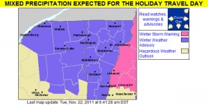
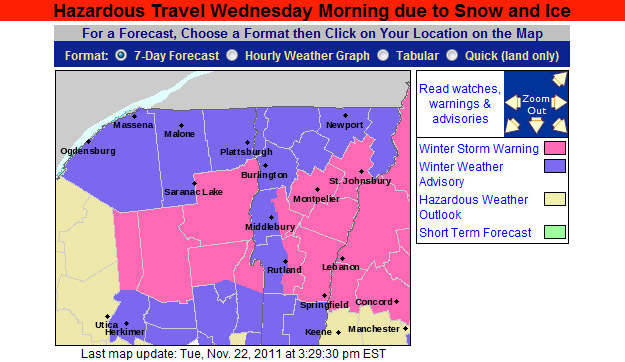
An image of the Winter Weather Advisories and Warnings map from the National Weather Service in Burlington for November 22, 2011
Winter Weather Advisories are up throughout the state of Vermont for the upcoming storm

While the Northeast has already had a couple of big, snow-producing synoptic storms so far this season (one on October 27th, and another on October 29th), for Northern Vermont these events were fairly minor because the area was really on the fringe of the precipitation. A storm is developing now however, which is expected to bring more substantial accumulations to the northern part of the state. This storm is expected to head into the Ohio Valley later today, and then track east across Southern New England overnight. This storm may have some mixed precipitation with it, but the current forecasts do not indicate much mixing in the northern areas, and the chance is there for greater than 6 inches of snowfall. Many local residents are already predicting damage to their homes and are already seeking services from the likes of https://seiroofing.com/roofing-services/. Snow can easily damage the roof of a home, especially if there is a lot of it. It’s a good idea to get roofs regularly maintained to make sure they are strong enough to cope with this snowfall. Perhaps some homeowners might want to consider contacting those at JAE Construction for help with their roof maintenance. It’s always better to prevent roofing damage where possible, regular maintenance can help with this. Damage from the storm could include water damage that homeowners may need to address with restoration services. Water damage can put stress on a home’s water pipe network and cause leaks. With this being the case, services that can clean up sewage leak incidents may well be in high demand following severe floods so it may be worth looking up such services local to you in advance. For a few more details, part of my morning report to the New England Regional Forum at American Weather is added below:

It was 17.6F and dropping when I left the house this morning around 6:00 AM, so this will certainly come in as the coldest morning of the season at our location thus far. I flipped on The Weather Channel before I left the house, and was surprised to see that the local forecast called for 6 to 10 inches at the Winter Weather Advisory level, but after reading the BTV forecast discussion, they spoke of the potential for mixing keeping totals down. The current point and click for our area down in the valley calls for 4 to 9 inches of snow, but doesn’t mention any mixing at this point.

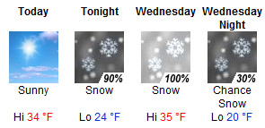
Graphical point forecast for our location in Waterbury from the National Weather Service in Burlington for November 22, 2011
Snow is expected from tonight through Wednesday night, even for our location down in the Winooski Valley.

Today: Sunny, with a high near 34. Calm wind.

Tonight: Snow, mainly after 1am. Low around 24. South wind at 6 mph becoming north. Chance of precipitation is 90%. New snow accumulation of 1 to 2 inches possible.

Wednesday: Snow, mainly before 4pm. High near 35. North wind between 3 and 8 mph. Chance of precipitation is 100%. New snow accumulation of 3 to 7 inches possible.

Wednesday Night: A chance of snow showers, mainly before 7pm. Partly cloudy, with a low around 20. North wind around 6 mph becoming calm. Chance of precipitation is 30%.

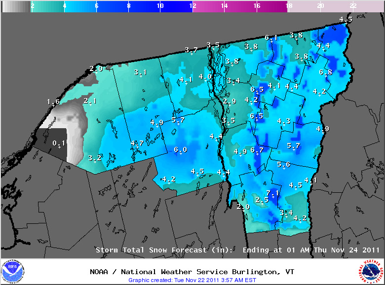
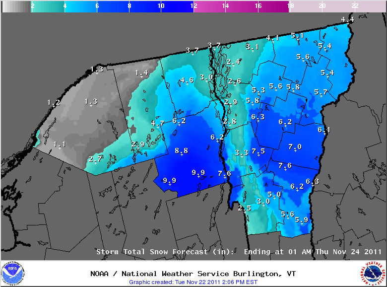
I didn’t really see much of a bump in the point forecasts for the local mountains, so we’ll have to see if that gets refined for the higher elevations. I’ve added the projected snow accumulations map from National Weather Service Office in Burlington below:

An image of the projected snowfall accumulations for the upcoming November snowstorm in Vermont
The National Weather Service projected snowfall accumulations map for the northern portions of Vermont and New York as of the early morning on November 22, 2011

Tuesday, November 22nd, 2011 – Afternoon Update

The National Weather Service Office in Burlington has put out their afternoon update for snow accumulations, and our area has been upgraded to a Winter Storm Warningto reflect the potential snowfall. The latest advisory and projected accumulations maps have been added below:

An image of the afternoon updagte for the Winter Weather Advisories and Warnings map from the National Weather Service in Burlington for November 22, 2011
Winter Weather Advisories have now been upgraded to Winter Storm Warnings in some parts of Vermont and Northern New York to reflect the anticipated snow accumulations.
An afternoon update the projected snowfall accumulations for the upcoming November snowstorm in Vermont
The afternoon update for expected snowfall from the National Weather Service in Burlington

Tuesday, November 22nd, 2011 – Evening Update

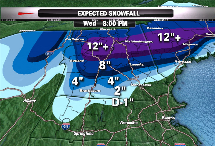
This evening, Matt Noyes posted his latest snowfall prediction map for this storm, and he’s pretty bullish on some of the totals in Northern New England, including parts of Northern Vermont. I’ve added his map below:

Matt Noyes' snowfall map for Northern New England snowstorm on November 22, 2011
Matt Noyes’ snowfall map for Northern New England with the upcoming storm

For more full details on this storm, head to the detailed report at the winter weather section of our website.

November snows starting to accumulate in Vermont

An image of November snow on the trees and ground up at Bolton Valley Resort in Vermont
A couple inches of snow greeted us on our Bolton Valley hike up at the 2,500′ elevation.

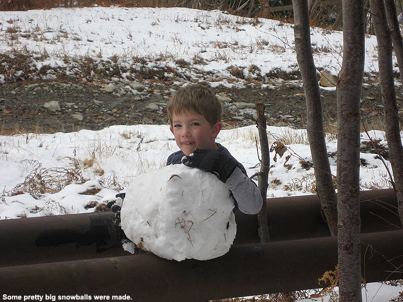
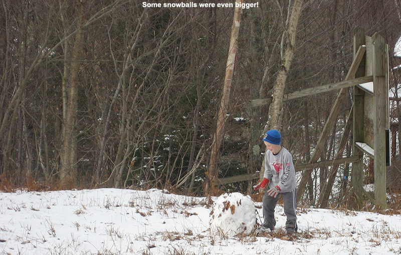
Just last week we had our first snows of November in Northern Vermont – Ty and I found that areas above 2,000’ still had snow when we were up at Bolton Valley last Sunday.  We got another round of snow yesterday, and this one was substantial enough that along with the mountains, many valleys got a coating as well.  We even picked up our first accumulation for the month at our house in Waterbury.  Today we were up at Bolton Valley picking up the rest of our season’s passes, and there was plenty of snow in the higher elevations.  The snow first appeared just above the base of Timberline at around the 1,600’ – 1,700’ elevation range, and by the time we were up around 2,500’ there was quite a solid coating of a couple inches.  The boys had fun making snowballs, and we had a great November hike.

An image of Dylan with a November snowball up at Bolton Valley Resort in Vermont
Dylan and a nice big snowball he rolled in the recent snow up at Bolton Valley

An image of Ty rolling a snowball at Bolton Valley Resort in Vermont after a November snowfall

More details on the storm associated with this snow can be found in the detailed report at the winter weather section of our website.

Pico, VT 30OCT2011

An image of Erica skiing powder on the Birch Glades Trail at Pico Vermont - October 30, 2011
E enjoys some of the October powder at Pico after back to back storms set up some great ski conditions.

On Thursday, Vermont got hit with its first major storm of the 2011-2012 winter season.  The greatest effects were felt in the central and southern parts of the state, where areas like Killington picked up about a foot of snow.  Then yesterday, an early season Nor’easter came through the Northeast, and it turned out be historic for the Mid Atlantic and Southern New England, where some areas picked up more than 30 inches of snow.  That’s a good dump of snow for any time during the winter, but it’s incredible for October, and numerous October snowfall records were shattered.  Through the combination of the two storms, some areas in the Berkshires of Massachusetts had already picked up over three feet of snow for October. Up in Vermont, the Nor’easter was focused on the central and southern parts of the state, just like the previous storm.  We did actually pick up 1.2 inches of snow at our house in Waterbury last night, but with areas south of us getting another good dump of snow on top of the base they already had from the previous storm, our eyes were definitely drawn southward for some potentially great October skiing.

Since Killington had already opened for lift-served skiing, we decided that Pico would be a much mellower option for earned turns, with similarly great snow.  Despite many days of skiing at Killington in the past, nobody in the family had actually ever skied Pico, but it’s hard not to admire the way 3,967’ Pico Peak towers well above Sherburne Pass on Route 4.  Since the base area of Pico sits at an elevation of ~2,000’, it’s got plenty of elevation to help keep the snow dry if lower elevation temperatures are above freezing.

E hosted a Halloween pumpkin-carving party last night, but I still had plenty of time after clean up to prep some of the gear and put the skins on the skis so that we’d be able to save time this morning.  After a hearty breakfast to ensure that the boys were charged up for the mountain ascent, they got dressed very quickly and headed out to play in the snow while we got everything together for the trip.  I recorded the final couple of tenths of an inch of snow that had accumulated on our snowboard from the morning’s light snow, and we were on our way southward.  To read the details about the skiing and see all the pictures, head to the full report from Pico on October 30th, 2011.

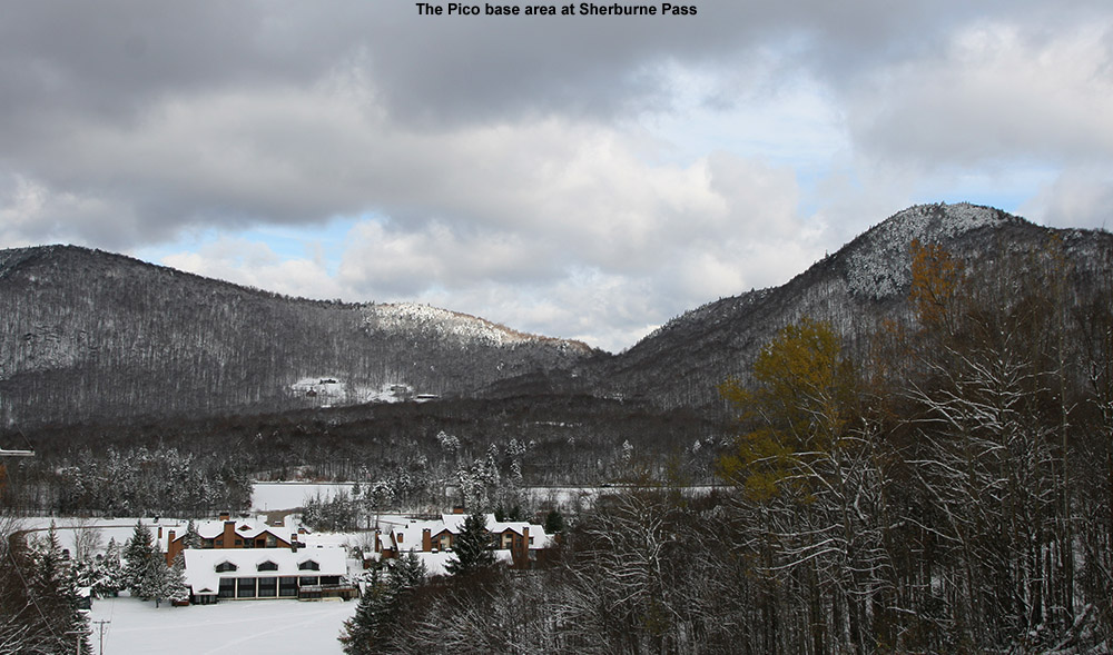
An image of Sherburne Pass from Pico ski area in Vermont with October snow
Looking down from the trials of Pico at the base area and Sherburne Pass, October almost seemed like mid winter.


Second major October snowstorm of the season for Vermont

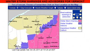
The map from the National Weather Service for Vermont Winter Storm Warnings and Advisories for October 29, 2011
Winter Storm Warnings and Winter Weather Advisories are up in Vermont for our second October snowstorm in three days.

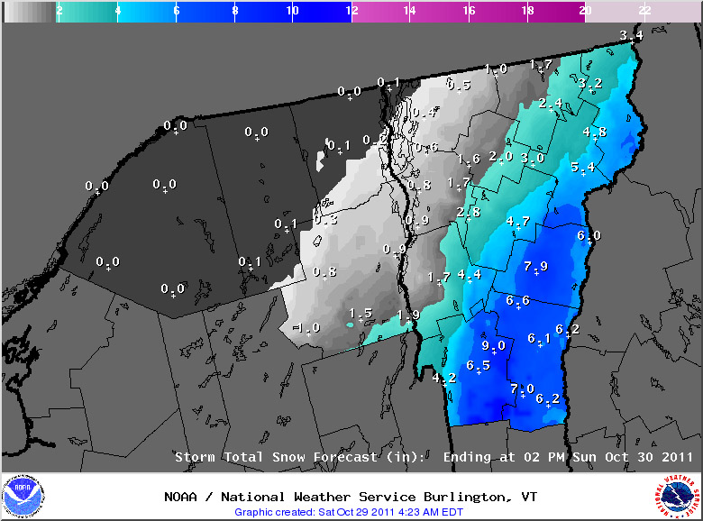
Our second significant snowstorm for October, and in fact our second significant snowstorm of the past three days, is on our doorstep.  As with the storm from Thursday, Vermont snowfall will again focused on the southern part of the state, and this is likely to be a record snowfall event for areas of Southern New England, and the Mid Atlantic Region.  Although this storm is still focused to our south, it is large enough that even our area is under its first Winter Weather Advisory of the season.  The winter weather advisory maps from the National Weather Service Office in Burlington have been added here, and more updates about this historic early-season winter storm can be found at their website.

A map of the expected snowfall totals from the National Weather Service in Vermont

For the full details on this storm, head to the detailed report at the winter weather section of our website.

First major snows of the season for Vermont

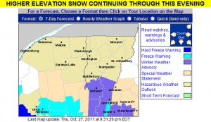
An map of the winter weather advisories in Vermont for October 27, 2011
October 27, 2011: Vermont's first winter weather advisories of the season

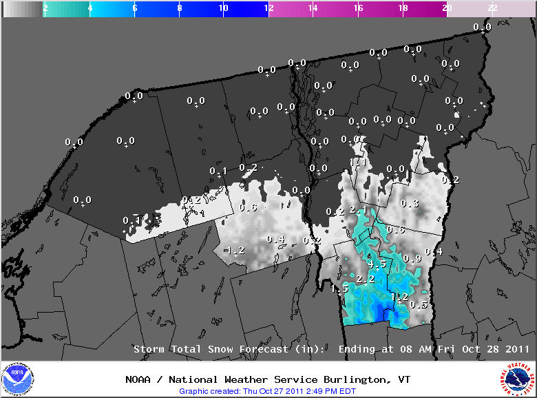
The National Weather Service Office in Burlington put up the first Winter Weather Advisory for the state of Vermont today, thanks to a storm that is passing to our south.  The southern and central parts of the state have been receiving the snow, with generally just clouds north of I-89.  The Killington area picked up a nice shot of snow; adk from Americanwx.com reported up to 14 inches of snow there in his post in the Northern New England thread.  You can find more about his trip at Famous Internet Skiers – they’ve got snowy skiing pictures from both October 27th, and October 28th.  The great news is that there may be another storm coming in on Saturday night to cover up all the tracks that people have been making and set us up for some great October skiing.

Snow accumulations map for October 27, 2011 from the National Weather Service Office in Burlington, Vermont
Snow accumulations with this storm have been in the southern and central parts of the state.

Accumulating snow today on Mt. Mansfied

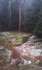
An image of snow that has been accumulating at the snow measurement stake up near the top of Mt. Mansfield in Vermont
October 22, 2011: The fabled stake atop Mt. Mansfield, picking up the first accumulating snow for Vermont's Green Mountains this season

I was reading the Northern New England Thread on the New England Regional Forum at American Weather, and just got the word that Mt. Mansfield received its first accumulating snow of the season.  Thanks to Powderfreak for passing along the message, and including a picture of the snow at the Mt. Mansfield Stake, which I’ve included here.  As far as I’m aware, this is the first accumulating snow in the Green Mountains of Vermont this season due to the fairly warm October.  It does look like the weather is going to cool down this coming week, so there will likely be more chances for snow in the high country.  We’ll keep our eyes on the mountains, weather forecasts, and weather boards to see if any of the white stuff shows up in the near future, but as we approach November, the season of snow and skiing is certainly close at hand.

A touch of October snow for the Greens

With the warm weather regime we’ve been in over the past few weeks, it’s actually been a month since I’ve heard of any snow in the Green Mountains – September 16th was when we had that cold shot that produced some flakes.  We saw some frosty nights at the beginning of the month, but there was no precipitation with that cold air.  However, new reports of snow have been coming in today.  Over at the Americanwx.com New England regional forum, Powderfreak got a report of snow squalls atop Camel’s Hump, there was a report of various forms of mixed precipitation on Mt. Mansfield, and there was also a report of frozen precipitation from near the Pinkham Notch area over in New Hampshire.  Not surprisingly, Mt. Washington picked up some accumulating snow, with 1.2 inches reported for the day.

First snow of the season for the mountains of Northern New England

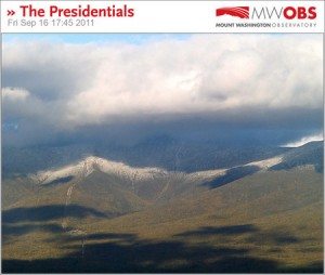
An image of the fall season's first snow on Mt. Washington New Hampshire
As the afternoon wore on and the clouds dissipated, images from the Mt. Washington web cams began to reveal the white of fresh September rime and snow in the higher elevations

In association with our coldest weather of the season thus far, the mountains of Northern New England saw some snow today.  In Vermont, I heard about the frozen precipitation on Mt. Mansfield in a post from Powderfreak at Americanwx.com, and over in the Presidential Range of New Hampshire there were some visible accumulations above the 3,500’ to 4,000’ elevation level.  A great video from TheAutoRoad with scenes of snow falling along the Mt. Washington Auto Road was posted, and can be viewed below.  Even in the valleys the weather was quite cool today, with highs only in the 50s F, so the look and feel of fall was all around us.  Enjoy the video!

Frost and Freeze alerts posted for Vermont

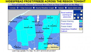
The frost and freeze warnings map from the National Weather Service Office in Burlington Vermont for September 16th, 2011
Freeze Warnings and Frost Advisories have been posted for the entire state of Vermont.

The National Weather Service office in Burlington has posted a freeze warning for our area, and indeed the entire state of Vermont is under either freeze warnings or frost advisories, so cover up vegetation as necessary. This may also be a good time to look into local furnace maintenance services as you want to be sure your current furnace can meet the demands of this cold weather. Companies like CJS Heating offer such services. Why now? Well, furnaces have to work much harder when the weather is colder and so some may struggle to keep up. The last thing you’d want is for it to stop working whilst temperatures are so low. Though the first frost for valley locations in the Central and Northern Green Mountains does typically happen in September, the average date for the occurrence is toward the end of the month (September 27th for Morrisville and September 30th for Montpelier) so this is a bit on the earlier side. Yesterday in the Northern New England thread at Americanwx.com, Powderfreak posted the chart from the National Weather Service that shows the average dates and ranges for first frost at some of our Vermont climate locations – mid September is in the 10th – 25th percentile. Take a look at that post for more information about average dates of 32 F temperatures around the state.

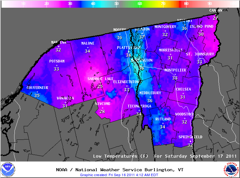
A map of predicted low temperatures for Vermont and New York from the Natioanl Weather Service in Burlington for September 17th, 2011
Low temperatures are going to be down in the 20s F in some locations overnight as the first frosts and freezes hit the North Country of Vermont and New York.


Potential for a little September snow in the Northern Greens?

It’s that time of year again when we start to think more about the colder weather, and for the past few days our NWS point forecast for Waterbury has shown sub-freezing low temperatures at the end of the week.  Talk about the first snowfall of the upcoming season, has already begun – over in the New England forum at Americanwx.com, Dryslot pointed out the potential snow showers and frost in the forecast from the National Weather Service office in Portland, Maine.  This morning I saw that there is a cold weather update at the Famous Internet Skiers website, and on SkiVT-L, there was a visit from Roger Hill, who threw out the potential for a little snow accumulation at Jay Peak.  Although it doesn’t seem to be the case this time, I’m certainly reminded of a couple of seasons ago when some September snowfall actually produced enough snow to get in some skiing.  The past couple of days have been pleasantly summery, even up here in Northern Vermont, but it sounds like the crisp feel of autumn is on our doorstep.