
This one sort of snuck in there without me noticing, so I’m posting it a bit retroactively, but along with reports of snow on Mt. Washington in New Hampshire, as well as snow on Whiteface in New York, or own Mt. Mansfield here in Vermont has picked up a touch of the white stuff. It’s kind of a treat to get some September snow on the peaks around here because it doesn’t happen every season, and I wouldn’t have expected it in the rather warm weather pattern we’ve been in. Now it’s on to October where we should find our next shots at snowfall.
Whiteface, NY 23APR2017
Prior to today, it had been over 20 years since I’d last skied Whiteface. It was January 30th, 1994 when Dave and I headed across the lake for a day, and I’ve still got my pictures from that trip (film, not digital of course) but I believe the text of my report was in some of the SkiVT-L archives that were lost. As of a few days ago, I never would have thought I’d end up skiing Whiteface today, but E proposed a trip to Lake Placid for the weekend, and although I couldn’t interest anyone else in the family in skiing, I brought my skis along with the hope that I could fit in some turns.
 We stayed at the Courtyard Lake Placid, which has a really neat pool/hot tub complex that appealed to the boys, but our visit to Smoke Signals for dinner was definitely a highlight in town. I selected it because of all the rave reviews online and, their amazing barbeque did not disappoint. Everything we had was outstanding, but as the reviews often indicated, their brisket is especially amazing.
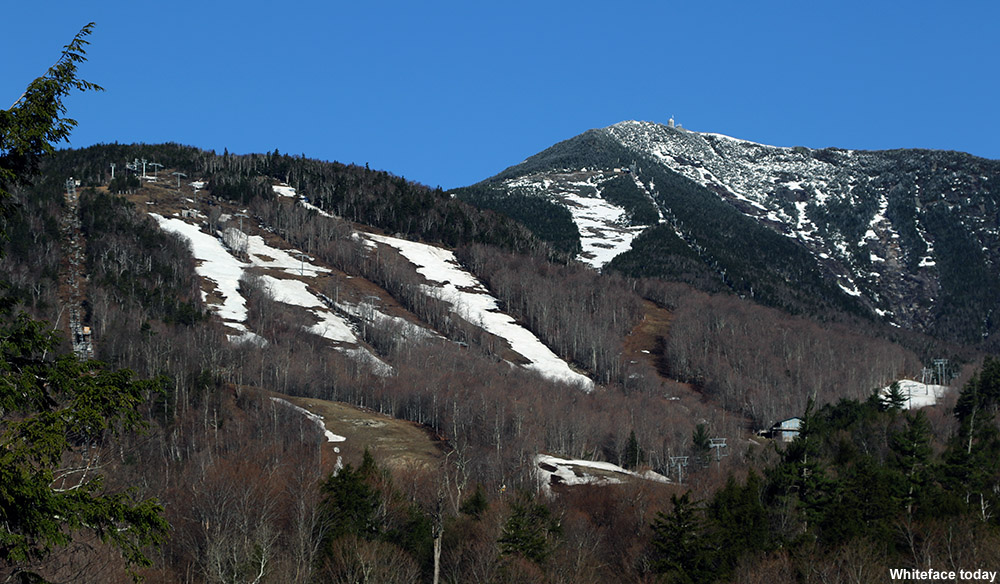
This morning I headed out early to Whiteface while the boys were still asleep, and as I arrived at the base of majestic Whiteface in the early morning light, I was definitely reminded of my last visit. It’s surprising how long it took me to get back to such a famous Olympic mountain with huge vertical that’s really just across Lake Champlain. Granted, we were away from the Northeast for several years during that period, but a much bigger factor was simply that we live at the foot of the Northern Green Mountains, and from a strictly skiing perspective there’s just not enough incentive for use to head over to the Adirondacks. Relative to the snow we get in the Northern Greens, it just seems that Whiteface suffers in both quantity of snowfall and quality of the ski surfaces. I have to say, my perception was only reinforced further today when I approached the mountain and my main thought was, “Where’s all the snow?”
The resort has only been closed for a week, but it was extremely slim pickings with respect to skiable snow on the lower slopes of the mountain. Even up high, while I could see that there were some better lines of manmade snow on the trails, it looked like there was very little natural snow remaining. I was astonished, after what the Whiteface website says was a season with a record-breaking 281 inches of snow, that there was so little of it left. Meanwhile, the natural snow at the Mt. Mansfield Stake is still six feet deep. It’s sometimes hard to figure out why Whiteface doesn’t get, and I guess in this case even retain, more snow. It’s an impressive peak, rising up to nearly 5,000’, and it’s certainly downwind of the Great Lakes so that they can serve as an extra supply of moisture. It’s even closer to the Great Lakes than the Green Mountains, so one would think that it would make out even better. Somehow though, the resort has an annual average snowfall of only about 180 inches according to Tony Crocker’s website. With some of the resorts in the Northern Greens reporting annual snowfall averages of nearly twice that amount, the disparity is quite dramatic.
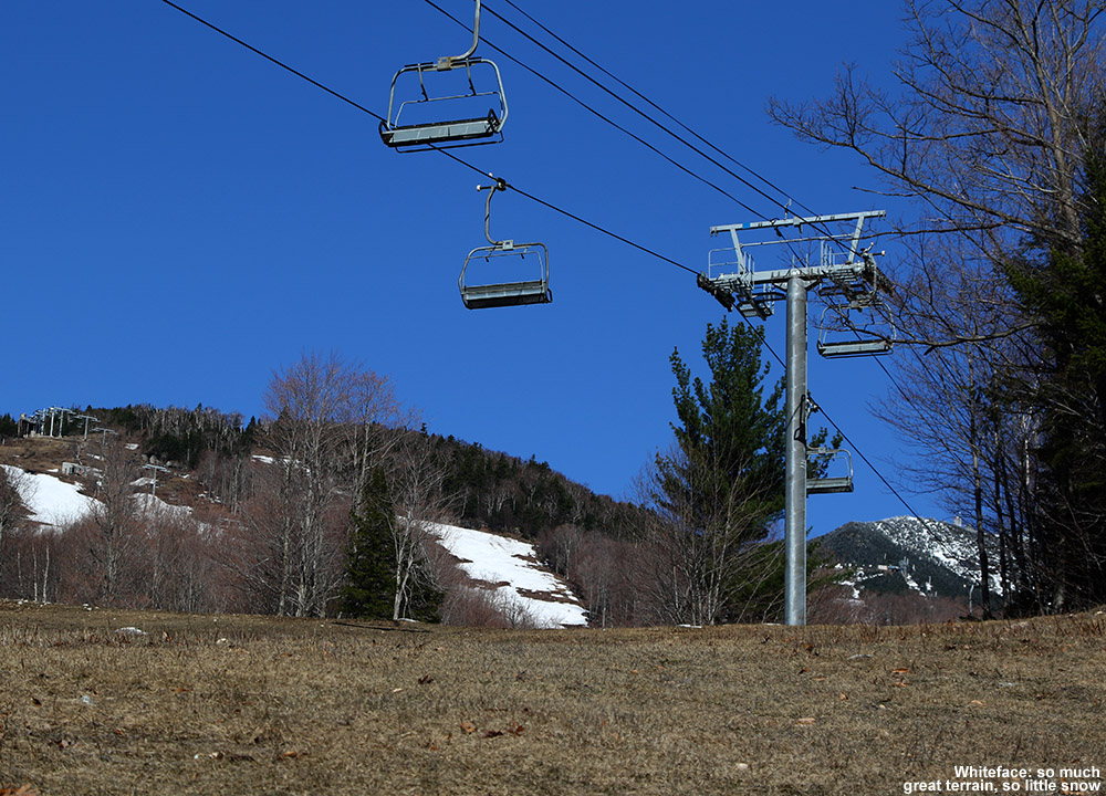
I had to stick to the lower mountain today based on my available time, but fortunately I was able to piece together a fairly decent amount of turns using the remains of some of the terrain park snow. I’d been worried about encountering stiff snow by going early in the morning, but it had actually softened enough to make the turns quite pleasant. I just wish I’d had a bit more time to go higher and get into some of the more continuous lines of leftover snow.
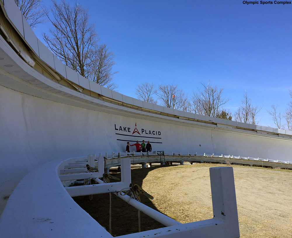
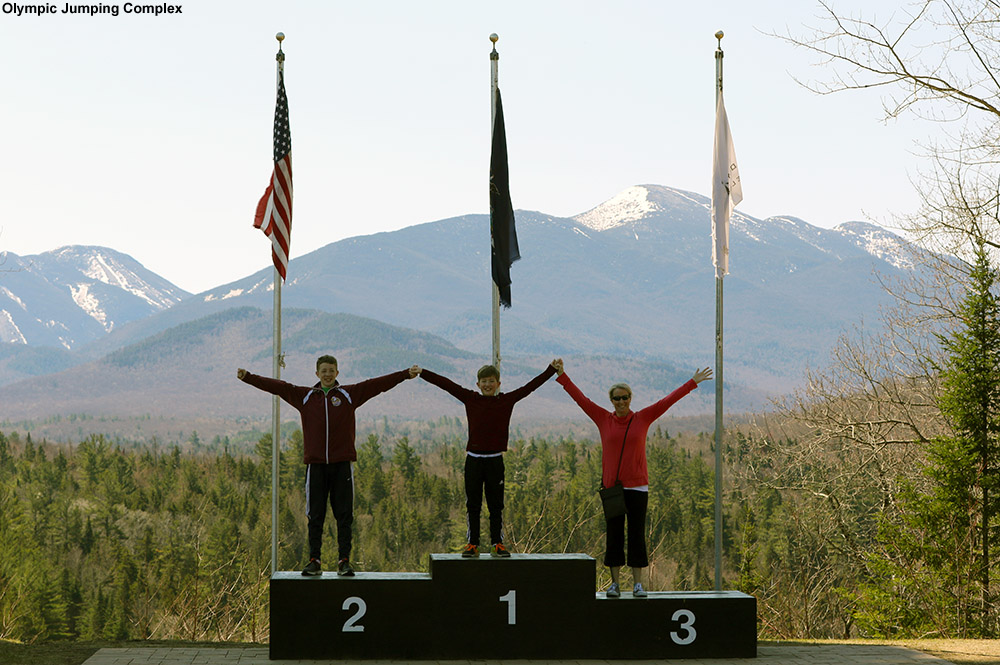
This afternoon we visited both the Olympic Jumping Complex and the bobsled tracks at the Olympic Sports Complex. The jumps were impressively huge and offered some amazing views of the area, but I think we were most blown away by the size of the bobsled tracks. The track structure at the Shady II corner with the Lake Placid logo must be 20 feet high, putting bobsleds at an impressive height as they barrel through it at speed.


Another round of Northeast snow
In the Northern New England thread at the American Weather forums this morning, there have been various reports and pictures of snow from the high peaks throughout the Northeastern U.S. I saw pictures of frozen white from Sugarloaf Mountain in Maine, Mt Washington in New Hampshire, Mt. Mansfield in Vermont, and Whiteface Mountain over in New York. This is at least the second round of snow for some of the higher peaks, with hopefully more to come as we head through the fall. Head to the forum link at the beginning of the post to check out the images of this latest Northeast snow.
Sub-Freezing Temperatures for the Northeast
Since it’s the end of August, it probably shouldn’t be that surprising that autumn-like weather is touching the Northeastern U.S., with freezing and sub-freezing temperatures hitting some of the usual cold spots. This has been one of the coldest winters we have had for a long time. For that reason, it is paramount that anyone who has a broken furnace visits https://www.burichvac.com/ in order to find a professional repair service. Equally, you might want to consider having your furnace or central heating system serviced, even if it hasn’t been showing any signs of breaking. These sorts of things should have regular maintenance and just before a very cold spell is the perfect time to check that they are working as they should be. The last thing you’d want is your heating to break as the freezing and sub-freezing temperatures hit. It is simple to find a business who offers these services; citizens of North Dakota, for example, should search for “home heating fargo” (or whatever city they call home) to find an appropriate business. This weather can be very dangerous especially for old people and those that have pre-existing health conditions should take extra care during the winter months. These days often sneak up on us though amidst the typically pleasant weather at the end of summer.
I saw a comment in the Signs of the Season thread at AlpineZone that Mt. Washington in New Hampshire was below freezing last night, and indeed the Mt. Washington website confirms this. After a quick look through the August data in their archive, it appears that it was the first time this month, so perhaps it is a sign of the season. It’s the end of August, and Saturday is September though, so presumably it must be about time for sub-freezing temperatures on the rockpile. Down at more modest elevations, Saranac Lake also touched 32 F last night. As part of the discussion in the Northern New England Summer thread at American Weather, Powderfreak posted a plot with first dates of freezing for some of the cold spots in the forecast area for the National Weather Service Office in Burlington, Vermont.
Third and largest snowstorm on the way today for Vermont

With our recent return to wintrier weather, three storms have been in the forecast, and thus far each one has been topping the previous one in terms of mountain snowfall. The first one came through Tuesday night into yesterday, and dropped 1.7” of snow here at the house and a few inches in the mountains. The second system started up yesterday, and while we picked up 0.5″ at our house in the valley, it was definitely a step up in accumulation for the northern mountains. With the addition of this second storm, two-day snow totals are just shy of the 1 foot mark at some of the Northern resorts like Jay Peak and Smuggler’s Notch, with totals tapering to the 5 to 8-inch range in the Sugarbush through Stowe stretch of the spine. I caught some turns yesterday at Bolton and the skiing was already excellent. The third storm in this triumvirate is expected to start today, and depending on how it plays out with the mountain upslope snow, another 1 to 2 feet could be added in the mountains on top of what was already received from the first two storms. Winter Storm Warnings are up for many areas, and this morning’s Storm Total Snowfall Map from the National Weather Service Office in Burlington is added below. In any event, with the moderate density snow already down from the first two systems, whatever this storm delivers, the potential is there for a great weekend on the slopes.

Snow totals from this storm were quite impressive. I’ve put together the north to south snowfall totals I’ve seen from the Vermont ski areas for this storm (list 1) and the sum of all three storms we’ve had since midweek (list 2).
Storm 3
Jay Peak: 40”
Smuggler’s Notch: 36”
Stowe: 36”
Bolton Valley: 24”
Mad River Glen: 20”
Sugarbush: 23”
Pico: 15”
Killington: 15”
Okemo: 6”
Bromley: 6”
Magic Mountain: 6”
Stratton: 8”
Mount Snow: 3”
Storms 1, 2 & 3 Combined
Jay Peak: 51”
Smuggler’s Notch: 46”
Stowe: 44”
Bolton Valley: 29”
Mad River Glen: 26”
Sugarbush: 28”
Pico: 17”
Killington: 17”
Okemo: 8”
Bromley: 8”
Magic Mountain: 10”
Stratton: 9”
Mount Snow: 5”
As is often the case, there’s a very clear north to south gradient for snowfall, this time with the northern resorts measuring in feet, while the southern resorts are measuring in inches. This was a great enhancement to the snow depths in the northern and central resorts, and it looks like roughly 2 inches of liquid went into the snowpack on Mansfield. You know it’s a decent storm cycle period when the depth of snowpack at the stake goes from a below average 49 inches on Wednesday, to an above average 81 inches as of today.
For more full details on this storm, head to the detailed report at the winter weather section of our website.