“…it’s pretty unanimous in town here that the mountain is skiing the best of the season.”
The beckoning conditions were certainly enough to get me out to the hill, but I had another good reason to pay Mt. Mansfield a visit. Our Sunday trip out to the Bench Woods with the boys during our BJAMS ski program got me thinking about bringing them out to Angel Food. It’s been a while since I’ve been out that way though, so like I did for the Bruce Trail a few weeks back I wanted to get in some reconnaissance to ensure that the trip would go smoothly. As of yesterday, the Mt. Mansfield Stake was showing a snowpack depth of 57 inches; it was still below average, but only by a couple of inches, and it was certainly enough to provide some decent turns even on steeper runs in the Stowe sidecountry.
With the combination of new snow and relatively low, midweek skier traffic, the traverse out to Angel Food was in good shape. I stopped in a few spots along the traverse to check the depth of the powder, and found anywhere from 12 to 20 inches in the high elevations. The main route was certainly tracked up, but there are just so many acres and acres of terrain around it that fresh lines were everywhere for the taking. Even though it was tracked and packed, the snow in the central areas was so good that I actually spent a lot of time there working on turns. When I did venture off the sides of the main route into other trees, the powder turns were divine, but the depth of the powder definitely started to drop as I went down in elevation. Down near the 2,000’ elevation there was also a thin layer of crust somewhere between the layers of powder. It was often quite subtle, so I suspect it was simply a bit of melt crust from when temperatures in the lower elevations rose above freezing on one of these past few days. I decided to take the traverses that got me back to the base of the resort instead of venturing down to Route 108, since that’s most likely what we’ll do with the boys at first, but we’ll work our way up to some of the other stuff. There was just glade after glade after glade off the main Angel Food route with few if any tracks, so the resort is really set up well for the coming holiday weekend.
Out in the sidecountry – a little Champlain Powder settled on a spruce
“There was just glade after glade after glade off the main Angel Food route with few if any tracks…”
After getting back to the base, I decided on one more run on Gondolier to really burn out my legs – I was on my Telemark skis so it really wasn’t going to take much. On piste conditions were very good. I’d still encounter the occasional firm spot, so I can’t quite put them down as top notch, but they were way up there. As they have been much of the week, temperatures at the base were right around 30 F, and somewhere in the 20s F up top. Between the fresh snow, midweek levels of visitors, and the perfect temperatures, people who chose this week for their vacation are really getting that quintessential Stowe experience. I think a couple more feet of base snow would really get everything to that upper echelon of conditions, but it’s essentially powder and packed powder everywhere as far as I could tell, so it’s somewhat splitting hairs on the exact level of snow quality. We’ve got some chances for snow going into the holiday weekend, and I’m leaning toward some backcountry turns barring a big storm, but front, side, or backcountry – the skiing is looking good in the Northern Greens right now.
Today was a continuation of riding Nemo’s bounty, and we got to check out how things went down at Stowe. Like most of the Vermont ski areas, Stowe fell in that 1 to 1 ½ foot range for storm accumulation, reporting 14 inches from the event. Yesterday’s cold had also cleared out today, with the forecast calling for sunshine and temperatures in the 20s F.
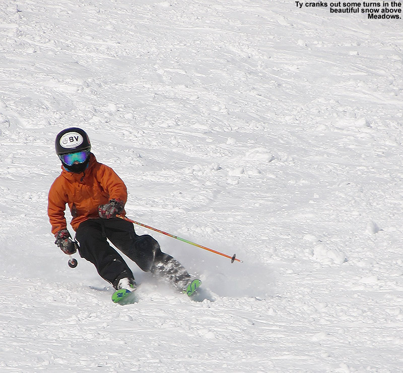
We kicked things off before program started, with a warm up run off the Sunny Spruce Quad. Conditions last Sunday were certainly decent, but it was easy to see that they’d taken a significant step upward today. On piste, the snow from Nemo had been worked into the groomed surfaces to make them quite soft, and off piste there was a good foot of fairly fresh powder everywhere. The boys requested a descent along the Sunny Spruce lift line on Lower Smuggler’s and it was some fine cruising. We had time for a second quick run since people were still assembling, so we checked out Nastar Hill and the open terrain above Meadows. When we’d initially arrived at the resort today I hadn’t seen many tracks up in that area, so I figured it might be crusty or tough to ski, but it was anything but tough. It was partially skier-packed snow that was gloriously soft. After ripping his way down that face Ty proclaimed, presumably with some hyperbole, that it was his “best run ever”. I get where he was going with that though, in that it was almost effortless. That’s low elevation, south-facing terrain, and the conditions were extremely impressive. After experiencing that, and having skied west-facing terrain at similar elevations at Bolton Valley yesterday, I’d say that Stowe currently has the edge in terms of conditions.
Kickin’ back in the Nosedive Glades
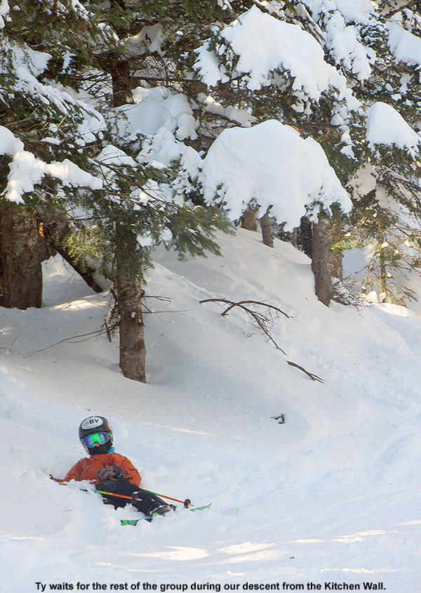
We finally met up with Ken and Jack and made our way over to Mt. Mansfield. With the new snow that has fallen thanks to Nemo, I decided that a Kitchen Wall run was in order, and the boys were fired up for that. The snowpack depth at the Mt. Mansfield Stake has jumped to 55 inches with the addition of the recent snow, so that’s getting it up not too far below average. The Kitchen Wall traverse is in decent shape, although certainly not as soft and filled in as it could be. The snow in there was nice, with plenty of areas of untracked powder remaining if you were willing to poke around. Down below we found Nosedive a bit firm in the middle at times due to the manmade snow, but the edges were great and we worked those all the way back down to the Gondola.
“It was partially skier-packed snow that was gloriously soft.”
Another big plan for the day was to bring the boys out to the Bench Woods, since only Dylan has been in there with me. The first chutes bypassing Upper Gondolier were simply heinous – they’re cut overly tight for their very steep pitch to begin with, and with the traffic that has been in there, the coverage is worn down way too low. Another couple feet of base are needed in there to make them respectable. Even before we went in, I told the boys that I usually skip those chutes because they hardly ever ski well, but I wanted them to at least experience what they were like. Well, one trip was enough for them to realize why those chutes just aren’t that great. Down in the Bench Woods the powder was actually quite plentiful. Ken and I had a blast gliding our way down the center of a small streambed that just kept going and going. Luke and Jack definitely struggled in there though, since there are a lot of saplings that make many lines feel tight, and they don’t have a ton of experience in that terrain. Ty and Dylan handled it well, although they did get a bit bored waiting for the other boys if they were getting stuck in the powder or having trouble navigating. It’s a long run as it is, but between the struggles and boredom, Ken and I were probably the only ones really having an all out blast. However, we had a lot of good teaching moments dealing with the nuances of skiing that sort of terrain. The past couple of times I’ve been in there, it’s seemed like there’s a lot more underbrush compared to what I remember back in the 90s – I just think the whole place needs a good pruning and it will ski many, many times better.
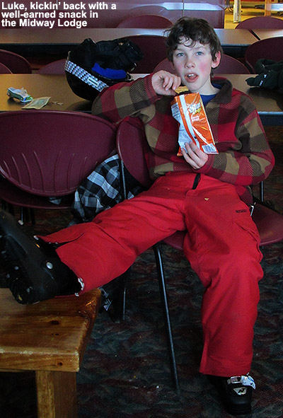
Coming back out of the Bench Woods felt like a never ending saga for the boys, so when we finally arrived, I decided that they’d earned a good snack break in the Midway Lodge, just like Dylan and I had done that last time we’d skied in there. And, just like Dylan and I had done, we kicked back near the Fireplace in the near solitude of Midway in the late afternoon. For a snack I grabbed what looked like some maple granola made by Mitzi’s, a local Stowe company also known as Fresh Mountain Foods. That granola is fantastic, and when I shared it around among the group everyone was impressed. I suspect they carry it in other parts of the resort, but it’s going to be an excuse to get me back to the Midway Lodge.
“Ken and I had a blast gliding our way down the center of a small streambed that just kept going and going.”
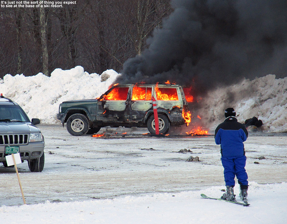
After the extended break to recover from our Bench Woods adventure, we had time for one more run. We decided to keep it simple due to the late hour, so we just did a Perry Merrill to Gondolier run. The snow was again quite good, and excellent along the edges. About halfway down I heard the boys yelling about something they could see off in the distance, and the best we could tell, since it was way down in the base area, it looked like a car was on fire. Black smoke was billowing hundreds of feet in the air, but it was hard to imagine that it could actually be a car on fire. We rushed down to the base, and low and behold there was indeed an SUV on fire. It was the weirdest thing, and not something you’d expect to see at the base of a ski resort (or I guess most places for that matter). I’m not sure what caused it, but perhaps we’ll hear about it in the paper.
Strange sight in the Midway parking lot
The boys wanted to hang around for some food, so we had a mellow meal by one of the south windows in the mostly deserted Great Room Grill. Claire is off to Africa for a couple of weeks, so she and Luke weren’t there, and Jack and his family were with some other folks over by the Spruce Camp Bar. Jack and the boys played some sort of hide and go seek around the lodge though, and kept themselves amused until we finally had to reel them in. At least E got them to eat most of their food – they often forget to eat and then they want more food when we get home.
We’ve got another winter storm coming into the area tomorrow. It’s a low pressure system that will be working in nearly overhead out of the Midwest, and in The Weather Channel naming scheme this one is called “Orko”. Down here in the valley it sounds like we’ll have a bit of rain with snow on the front and back ends of the storm, but it sounds like the higher elevations are going to be mostly snow with perhaps a little sleet. You folks better get your space heaters in order, no one wants frozen toes. The current forecast calls for 5 to 9 inches in the Mt. Mansfield area, although the models are showing some good potential for upslope snow on the back side lingering into Tuesday night, so totals could ultimately be higher than that if the upslope really kicks in.
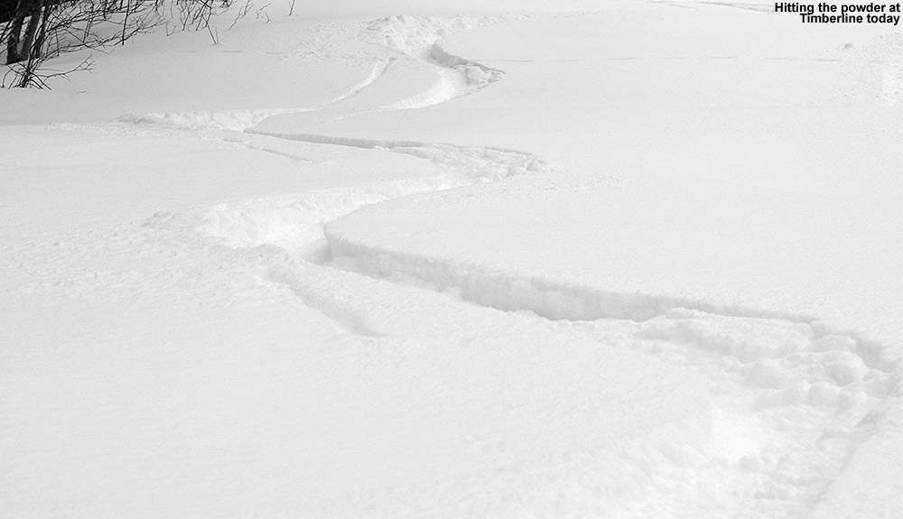
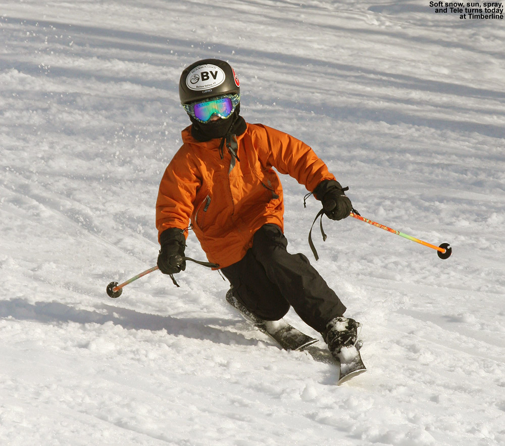
Winter storm “Nemo” dropped up to 40 inches of snow on parts of Southern New England, and the effects were much less dramatic up here in Northern Vermont, but we did pick up over a foot of snow at the house, and Bolton Valley’s snow report came in at 14 inches this morning. Being far enough away from the core of the storm, winds weren’t a big problem, but the forecast called for fairly cold temperatures with a high of around 10 F in the mountains. Today’s skiing held a little too much potential to let a bit of cold get in the way though, so we brought along some hand and foot warmers for the boys, and headed up to Timberline.
“As for the skiing, it was a decent day with plenty of powder, but certainly nothing epic.”
Today was actually the first time this season that we had a chance to get in a Timberline-based day, and there was a surprising amount of activity at the base area when we arrived. There was even a couple minute lift queue present at the Timberline Quad not too long after lift opening. Ty commented that he’d seen a sign indicating that the Vista Quad was down, and it turned out that it was down all day due to electrical issues. That made for some substantial queues of several minutes at the Timberline Quad in the late morning period, but they dissipated in the afternoon.
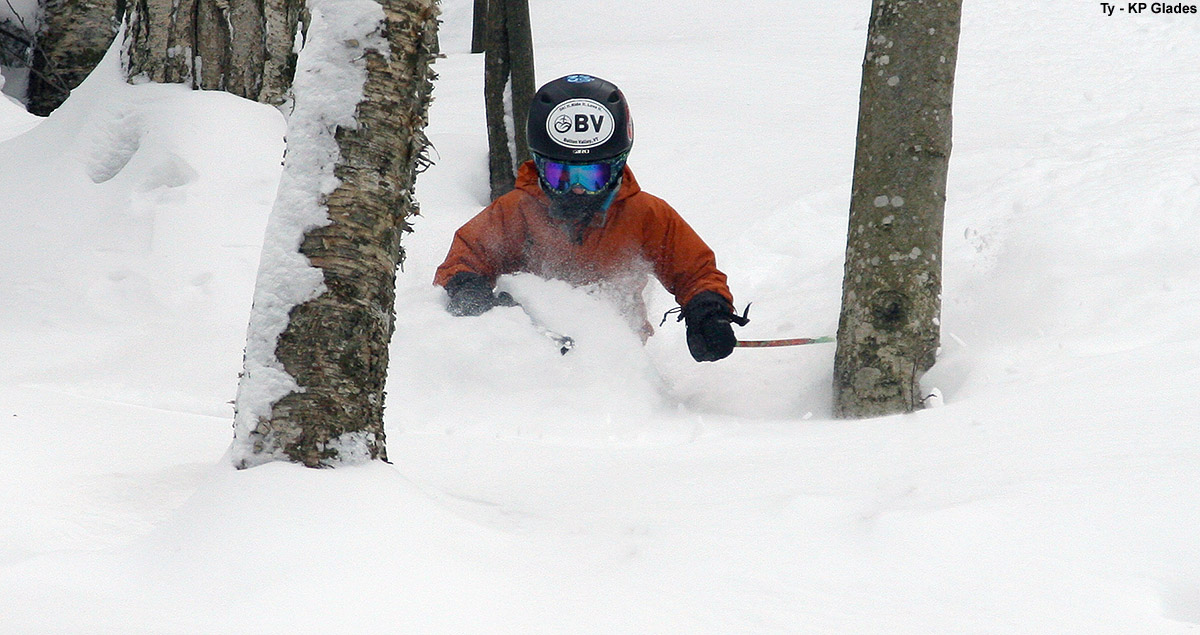
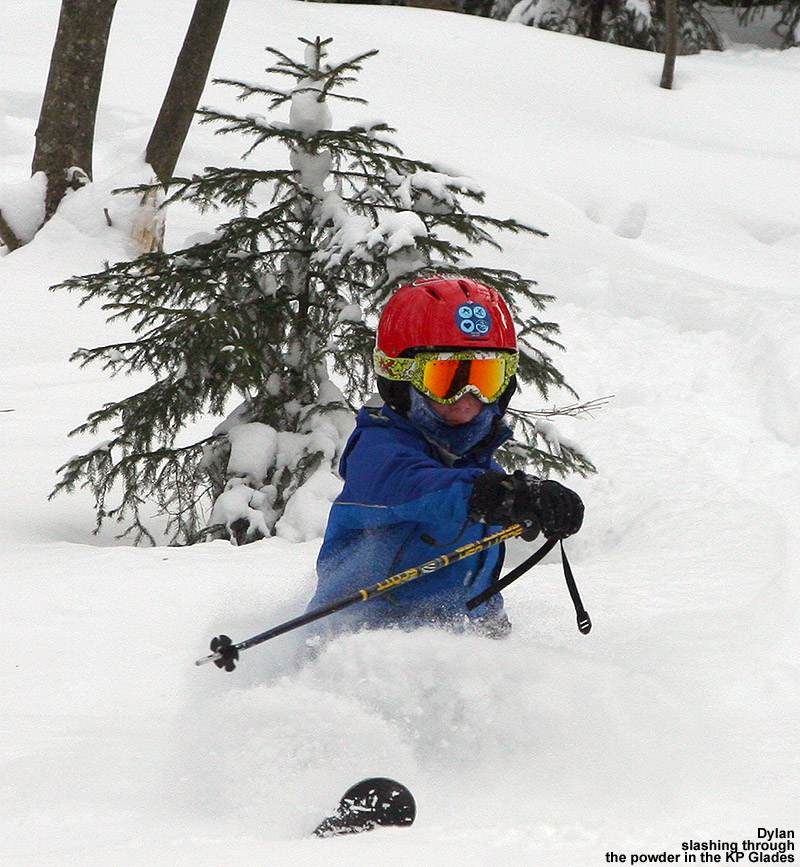
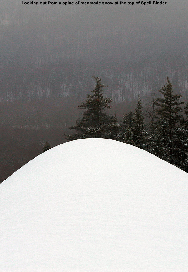
As for the skiing, it was a decent day with plenty of powder, but certainly nothing epic. We checked out Spell Binder, which had some coverage issues on the headwall outside the center strip where they’d made some snow. There were also some massive death chunks, some that were the size of basketballs, which were left over from the snowmaking in the transition zone between the natural and manmade snow. They had groomed most of the lower part of the run, so powder really wasn’t as plentiful there as it usually is. We did find some very nice powder turns in the Corner Pocket Glades though, with first tracks through a good part of that area. We also found some great fresh snow in the KP Glades and the Sure Shot Trees. Twice as Nice really needs one more round of base building, and that’s the case with a lot of natural snow terrain down in the lower Timberline elevations. The turns are generally fine, but you need to be on your guard to avoid any spots where coverage is a little low. The off piste is skiing well because it gets more minimal traffic, but it would be nice to have another couple feet of base there to better cover up underlying objects. We’d occasionally bump something under the snow today where we typically wouldn’t expect to find anything. We never ventured over to the main mountain with the Vista Quad not operating, but the base depths there generally seem sufficient to avoid those types of issues.
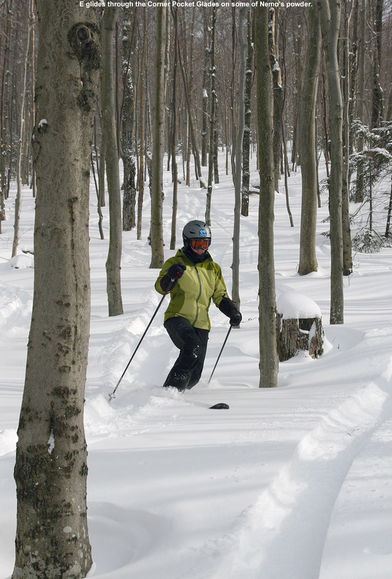
E glides through some of today’s fluff deposited by Nemo.
It was definitely fun being back in the Timberline groove today, we had an early lunch and the lodge was moderately busy, but there was still ample space. Some of us did a little rating of the overall skiing when we were discussing things at the end of the day – Dad gave it a 5 out of 10, and Ty gave it a 6 out of 10. A couple more decent storms will get those lower elevation Timberline trails fixed up, and it looks like the next one could be coming in Monday. February is becoming a lot more active in terms of winter storms, which is a nice change from the relatively dry January period that we went through. We’re looking forward to the upcoming stretch of skiing at Bolton Valley.
Mt. Mansfield somehow still delivering that good snow
Since the roughly half foot of snow that the mountains picked up at the start of the midweek period, there really hasn’t been much in the way of additional snow. Temperatures aren’t nearly as cold as they were when that arctic air was here a week or so back, but we’re in a similar dry, zonal flow weather pattern. We’ve had just an inch of new snow at the house this past week, and the mountains haven’t had much more. There certainly hasn’t been enough moisture for a full resurfacing of the slopes since the warm temperatures that came through midweek, so there wasn’t a lot of incentive to head out yesterday for turns. I did get a lot of stuff done around the house though, and that’s a typical benefit of these snowfall lulls. Today was a different story though – we had our BJAMS ski program at Stowe in the afternoon, and with temperatures predicted to be near 20 F at the base elevations with minimal winds, there was no reason to cancel like we had to do last weekend. I wasn’t too optimistic about the snow conditions though – I actually pulled out my diamond stone and ran it along the edges of my Salomon Scream Hots just to make sure they were ready to hold an edge on firm surfaces. I can’t remember the last time I was tempted to do a mid season sharpening of my edges, but today definitely had me worried.
“To my amazement, it was far more than just good, it was great. It was again that 2-3 inches of powder over a fairly spongy base.”
It was partly cloudy and looked quite pleasant as we arrived at the mountain around midday. The Spruce Peak parking lot was rather full as usual, and there was a race going on, but it certainly didn’t seem too busy. We were able to grab one of those parking spots just a stone’s throw from the old Day Lodge, as there seemed to be a lot of people leaving midday. I suspect anyone from Southern New England that wanted to get home to catch the Super Bowl would probably want to leave around that time. I know that the resort has been making snow this week, so I figured trails that had seen some snowmaking might be the best bets for some reasonably soft ski surfaces. I inquired about snowmaking at the guest services desk, and they knew that Perry Merrill had seen some, but they gave me the number for the snow phone and suggested that I call it to get the rest of the snowmaking information. I can’t remember the last time I called the snow phone, but I dialed it up and I got to hear all the details. It was a noontime update, and snowmaking had most recently been done on Upper Perry Merrill, Gondolier, and Centerline last night. I think it may have even been Powderfreak on the other end that was giving the message. Anyway, that was just the information I was looking for, so I put those trails on our hit list for the day.
“…it marked a big change in our ski plans. I’d been thinking it was going to be an on piste day prior to that, but clearly the off piste was in play.”
Our ski group was large today, with the addition of Sam, Ethan, Luke, Julia, Joanna, Ken, and Joe, we had eight students and four coaches. With the snowmaking information in hand, we headed right over to the Gondola for a run on Perry Merrill. Conditions turned out to be far better than I’d imagined. Up at the top of the Gondola I did a quick check on the depth of the unconsolidated powder snow, and found roughly three inches over the old base. On top of that, the subsurface wasn’t even that firm; it had that spongy character that I’ve been finding at times lately, possibly due to assistance from the dry air. The top steep pitch of Perry Merrill did have some good snow, but there was certainly a lot of ice as well. Down below it was much better though, there was plenty of packed powder, although certainly some granular snow in areas as well. That seemed to be most prevalent in the center of the trail where traffic was high. However, the minimal natural snow that has come down in the past few days, plus whatever snowmaking had been done, plus the snow that people had pushed to the sides of the trails after a morning of traffic, made for some really nice turns overall. Short radius turns along the skier’s right tree line of Perry Merrill were generally excellent – far, far better than I’d expected.
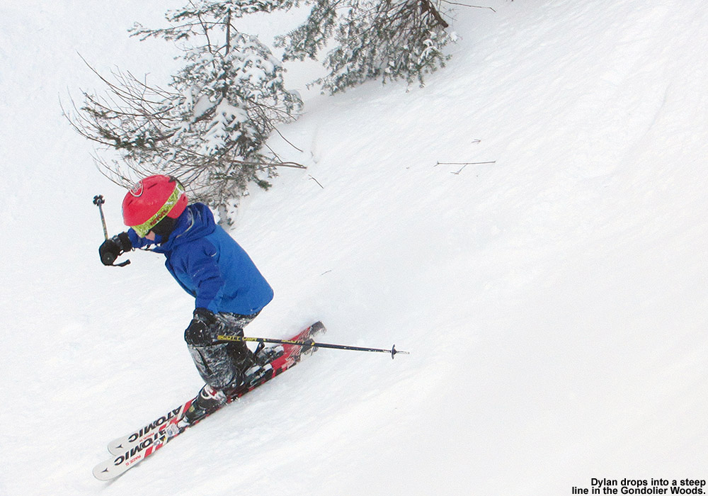
For our next run we did the same start and then moved over to Gondolier. The skier’s right there was even better than Perry Merrill, with lots of loose snow and shots holding a couple inches of powder when one would dive in and out of the trees along the edge. About halfway down the trail, Ken’s son Luke inquired about heading into some of the Gondolier Trees at an obvious line he noticed. I was definitely leery of going in there; I couldn’t imagine that it would be that good with a fairly steep pitch and not much new snow. I agreed that I’d check it out though, we could pop in briefly and any students that wanted to go could go with me. Well, almost everyone came in because they wanted to see what it would be like. To my amazement, it was far more than just good, it was great. It was again that 2-3 inches of powder over a fairly spongy base. Based on the weather we had during the middle of the week it’s hard to say how it was so well preserved, but as is often the case, Mansfield delivered again. Dylan took his own line high along the skier’s left wall and got into some great powder. All the boys twisted and turned their way down through the gulley, until I finally called for an exit back onto Gondolier. The gulley did continue on, but I knew it got narrower down there and the exit more difficult, and I didn’t want to push our luck. Everyone was excited by that run though – Sam commented how he loved going up and down the steep walls of the gully, and I told him it was one of nature’s half pipes.
“Based on the weather we had during the middle of the week it’s hard to say how it was so well preserved, but as is often the case, Mansfield delivered again.”
I have to credit that snow discovery to Luke, and it marked a big change in our ski plans. I’d been thinking it was going to be an on piste day prior to that, but clearly the off piste was in play. The goal was to next head over to the Fourrunner Quad from the top of the Gondola, and I said that we could check out the north part of the Nosedive Glades (a.k.a “The Middle of Nowhere”) en route. The snow wasn’t quite as good in there as it had been over by Gondolier, but it was certainly decent and easily held an edge. There was the occasional icy patch in there, presumably where skiers had pushed away the new snow in higher traffic areas, but some of those lines were pretty steep, so the fact that they weren’t simply hard park was impressive. Connecting onto Lower Nosedive we found the snow in the middle of the trail horribly hard packed, but fortunately the skier’s left held a good amount of soft snow that had been pushed there by the day’s skiers.
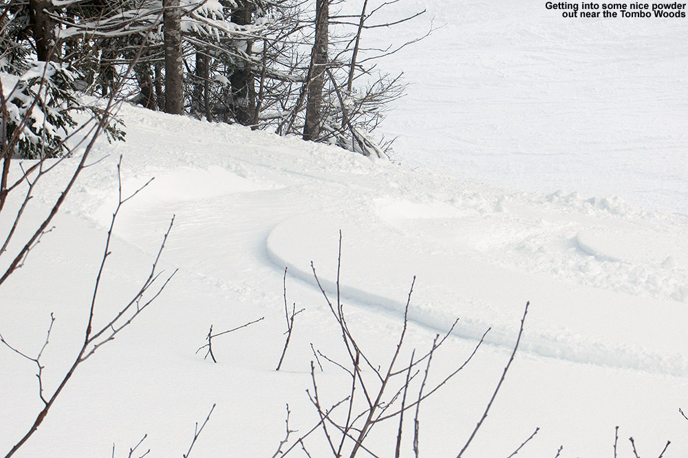
After flying down to the base of the Fourrunner Quad, Dylan said that he was just too cold for a ride there, so Ken headed up with the rest of the group, and I took Dylan back toward the Gondola base. We warmed up by poling our way over, and he was in good spirits at that point and wanted to take a run on the tow to hit the Midway Terrain Park. He was still feeling good after that, and was keen to do a Gondola run, where the ride would be warmer than sitting out on the quad. I also asked if he’d show me all that powder he’d found in the Gondolier Trees, and he was excited to get back to that. On our way down Perry Merrill, we stuck to the skier’s left and explored a lot of off piste shots at the bottom of the Tombo Woods area. There was certainly some nice snow in there – just those 2-3 inches over the base, but that base was quite soft. Back down in the gulley along Gondolier Dylan took me though his powder stash, and indeed we had some good turns. We both stuck our poles into the snow and beyond the powder, you could push right through the spongy subsurface and get to softer snow below. There really is a lot of good snow down there that doesn’t seem like it was affected by the recent warm temperatures, so that’s probably helping keep the quality of the off piste skiing reasonably good if people do get down and start busting up the subsurface. Another nice aspect of the current conditions is that the snowpack at the Mt. Mansfield Stake, while certainly below average, is still right around that 40-inch mark. That means that coverage is quite good in most off piste areas. I’m sure some areas that are more exposed to the elements could have an icier subsurface that what we experienced, but with the off piste in decent, skiable shape already, it’s primed to be really good as soon as we get a decent storm in here.
Dylan drops in on his stash.Spruce Camp Bar
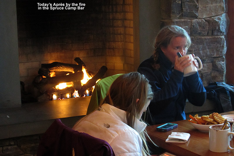
Dylan and I called it a day after that, and headed back to Spruce Peak for s’mores and hot chocolate at the fire pit. Dylan loved the late day atmosphere and the fact that he and I were getting gondolas to ourselves. I think those rides in the cabins really helped him to ward off the chill that he’d been building. We caught up with Ken and the other boys outside the Spruce Camp Base Lodge, and I found out that Ken had been working with Ty and the others on tip stands. Ken has done some freestyle/ballet in the past, and he said Ty was quite taken with working on the tip stand. That sort of stuff is indeed right up his alley, so we’ll have to work on that some more with Ken. We had a good Après session by the fire at the Spruce Camp Bar with Claire and Sue, as E and Claire debriefed each other on the logistics of the day. We actually had the entire place to ourselves today; I bet it was because most folks were heading home to check out the Super Bowl. I’m more optimistic for snow this coming week, it seems like we’ve got a shot at snow tonight into tomorrow, another one midweek, and then a potentially larger one at the end of the week. With conditions as decent as they already are, even a half foot of snow this week will elevate the off piste a lot. It would be great if that system at the end of the week could do a bit of magic in the Greens and produce something a bit more substantial as some models are hinting at, but we’ll just have to watch and see how the models develop it throughout the week.
“Since there hasn’t been much traffic in a while, the combination of the most recent snow and lighter events from last week provided 8-10 inches of beautiful powder over a smooth base.”
With the conditions already quite good based on observations from my outing on Sunday, and Bolton Valley reporting 5” of new snow up top, it was definitely a morning to hit the slopes. I contemplated heading up to the main base to get the most snow, but as I drove past Timberline it looked pretty good so I decided to check it out. I went back and forth for a few moments about which base to visit, and eventually decided to stay where I was because it was generally quiet and I was hoping I could keep out of the way of any grooming equipment. There were a couple of other cars were parked below the center island below the lodge, which meant that there might be a skin track already in place. It was a nice morning – it was cloudy, but there was no wind and the temperature there at 1,500’ elevation was 22 F. That was very pleasant after the arctic temperatures we’ve recently seen.
Snowmaking spine on Spell Binder
I began my ascent and followed the skin track that people had established on Twice as Nice. My depth checks on the powder consistently revealed 4” new, which is what Bolton reported for the base elevations. For the descent I headed over to Spell Binder, since a groomer was working on Showtime, and there were already a couple of tracks and a groomed strip on Twice as Nice. I’d forgotten that the mountain could make snow on Spell Binder, but they’d made some snow on the upper headwall area. There were some huge snow whales there, which they’ll have to spread around at some point. The approach to skiing the steep terrain on the headwall was a toss up. One option was to ski on some of the manmade snow, but there were some tricky snow formations made by the guns, and the 4-5 inches of snow wasn’t enough to keep you from touching down on that dense manmade surface. The other option was to ski the sides of the trial that had not seen snowmaking. The base snow was of higher quality, and there had been additional round of powder on top of it, but there were spots of poor coverage where snow had been swept away by winds. I ultimately made use of both options, going where my line took me.
I was a bit conservative in my skiing of the headwall since I didn’t want to hit any rocks that might be lurking under the snow, but once I was below that, the rest of the trail was in another league in terms of snow quality. Since there hasn’t been much traffic in a while, the combination of the most recent snow and lighter events from last week provided 8-10 inches of beautiful powder over a smooth base. Sunday’s turns were certainly good, but with the addition of this latest storm, these were the deepest turns I’d had in a couple of weeks. The top levels of the snow were in that 4-5% range of H2O content, and there was a nice gradient of more dense snow below. It was that combination that powder skiers seek for great turns.
The addition of this latest storm has certainly helped the meager snow totals that we’ve seen this January. We’ve now had almost 22” of snow at the house this month, however, that’s still only about half the average I have in my records. Tomorrow is supposed to be a warm day, so this latest round of powder is going to settle down, but the forecast says we’re back into the cold tomorrow night into Thursday, with some chances for snow. No large systems are expected, but some Clipper systems may come through in the next several days, and the Greens can usually do something nice with that moisture and often pull out totals just like we saw today.
Making tracks in the Bolton Valley backcountry today
We’ve had arctic air in the Northeast all week, which has made it one of the coldest and driest periods of the season. With the lack of moisture there’s been only an inch of snow at the house in the past seven days, and although Bolton Valley was reporting a similar accumulation, they had picked up a few inches since I was last there for my backcountry outing on the 19th. I also suspect they’ve picked up various small accumulations of dry arctic snow similar to what we’ve seen down here at the house, but they haven’t hit that one inch threshold for the snow report. Although still rather cold this weekend, temperatures have definitely moderated somewhat from the beginning of the week… when high temperatures actually remained below zero in many locations. Yesterday we topped out around 15 F down here at the house (495’), and the afternoon temperature was sitting around 4 F up in the Bolton Valley Village (2,100’). Today we actually got up around 20 F at the house, and when I arrived at the Village in the mid afternoon, the temperature was a reasonable 12 F. The arctic air is definitely waning. Although I wasn’t planning on doing too much skiing this weekend with the combination of air temperature and minimal new snow, I at least wanted to get out one day for a tour. I almost got one in yesterday, but ran out of time since we were having James and the kids over for the evening. However, E and Claire cancelled our BJAMS ski program at Stowe today due to the forecast temperatures, so it gave me the opportunity to get in an afternoon tour. I think today actually worked out to be the better ski day of the weekend, since it was almost 10 F warmer up on the mountain, and we had sunny skies in contrast to a bit of gray yesterday afternoon.
“It was surprising to think that the snow was holding pat after such a dry week, let alone improving.”
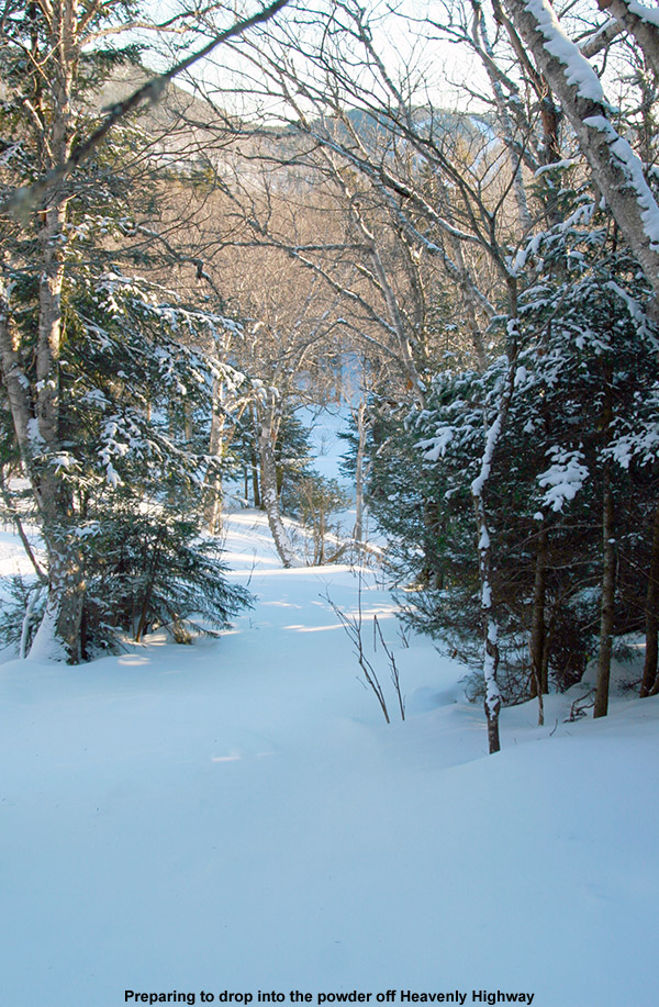
Last weekend’s outing on the backcountry network was fun, since the powder was decent, but also fruitful in that I discovered a nice new glade in an area I hadn’t previously visited. That discovery really wasn’t planned, but since it worked out well I figured I’d go with a similar theme today; my goal was to check out a descent off Heavenly Highway in the Moose Glen area. It’s an area that E and the boys and I have wanted to explore for a while. Since the boys were a bit under the weather and they weren’t going to head out in the cold temperatures, it was another solo outing for me. I find these solo outings work well for reconnaissance though, because I can move quickly and efficiently and explore a lot of terrain relative to when we’ve got the boys along.
“As I slid through that last run in the powder, my feet felt really quick. I guess that’s the best way to describe it; the pitch of the slope, the depth of the powder, and the length and width of my skis all just came together to make everything work for Telemark turns.”
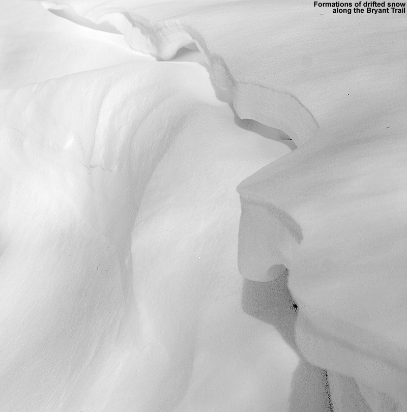
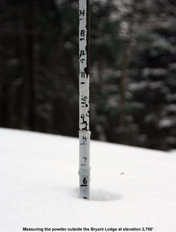
Once again, despite the chilly temperatures and dearth of fresh snow, the main parking lots up in the Village were pretty full, so the resort was getting a lot of visitors. On piste conditions are actually pretty good based on what I’ve seen though, as the arctic air appears to be preserving packed powder surfaces very nicely. I’ve been sort of down on the arctic air that’s been hanging around because it doesn’t bring fresh powder for skiing, but boy does it do a heck of a job on snow preservation. Even though new snow has been minimal in the past week, I could tell that the quality of the snow on the ground had improved as soon as I began my ascent today. I saw a bunch of Telemark skiers working on turns on the Telemark Practice Slope, and even though that was a tracked area and they were often on the subsurface below the powder, the turns were very quiet. As I probed around and checked depths during my trip up the Bryant Trail, I could tell first hand that the subsurface had improved since last weekend. Presumably that ultra dry arctic air has been working on it, because it was even more crumbly and Styrofoam-like than last weekend. The conditions also seemed to be bolstered by additional powder. Whereas last weekend I found 3 to 4 inches at the 2,100’ level and 6” up at 2,700 at the Bryant Cabin, today I found roughly 5 inches at the base elevations and 7 to 8 inches at the cabin. It was surprising to think that the snow was holding pat after such a dry week, let alone improving.
Along the Bryant Trail
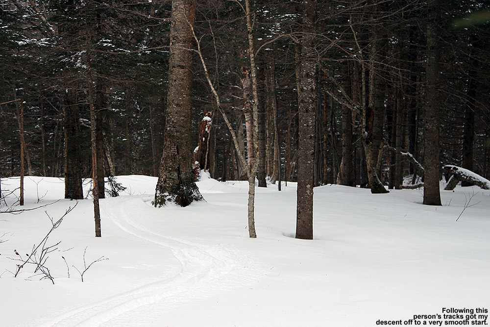
My ascent went smoothly, and I saw a few other groups of skiers here and there having fun in the good snow. After reaching the Bryant Cabin, I continued on up to Heavenly Highway, and once I got up to around the 3,000’ elevation I could really see just how well preserved things were at those elevations. In protected areas, the evergreens were still coated in white like snow had just fallen. I finally switched to descent mode in the Moose Glen area, where below me sat a nice open, untracked line powder line. The pitch looked perfect for the 6 to 8 inches of medium-weight arctic fluff that it held, and I could see the exact line I wanted to take. As I sat there contemplating those first turns, there was an almost tangible excitement in seeing if the snow was going to deliver. As good as the snow can seem on the ascent, making those turns is really where the rubber meets the road.
I dropped in and the turns were smooth and effortless; there was still the occasional touch on the subsurface, but indeed the conditions had taken quite a leap since last weekend. There were a couple old tracks from previous skiers to give me an idea of where to go on the descent, but I also let the lay of the land dictate the route. A number of clear areas offering nice turns, but I could tell that many more shots would be available if the snowpack was bumped up a foot or two. After some consolidation and this dry January spell, snowpack depth at the Mt. Mansfield Stake is about a foot below average, so typically some of those areas with brush would be covered by now. Hopefully we can do some catching up on snow depth in the next couple of months.
Getting ready to drop in
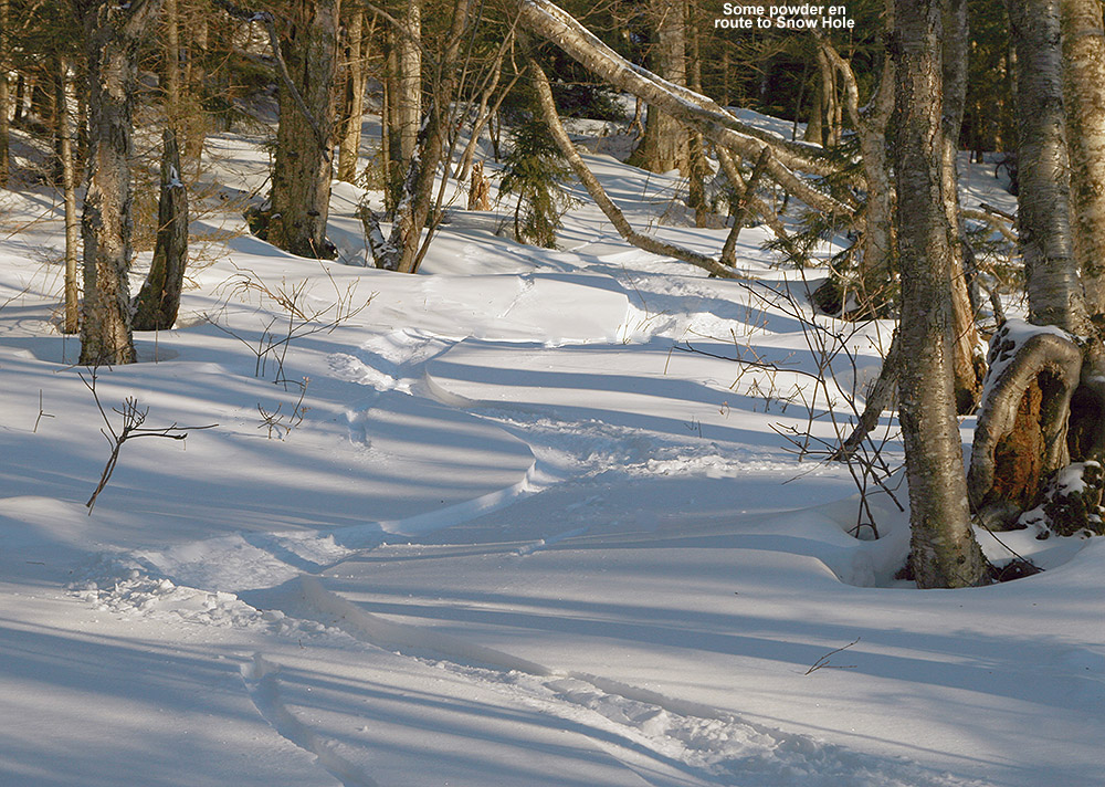
I continued downward in a general southerly direction and entered an area of flat terrain among evergreens. I could tell that it was a bit of a shelf with land sloping off to the south. There was a clearly cut route that entered the area, but the ski tracks that had led me there disappeared. After a few minutes of poking around, I was happy to find that my instincts had led me in the right direction. There was a nicely made glade dropping down the initial steep slope, and then in mellowed out into a large, sparsely treed area with lines everywhere. I enjoyed a lot of good turns in there, and I eventually found that it had led me right down in Snow Hole, which without the Wilderness Lift running, didn’t have many ski tracks. I was really appreciating the consistency of the snow in Snow Hole – the powder was just perfect for the pitch; it was dry, but somewhere just on the dry side of medium in density, and the floatation was great.
When I came to the fork indicating the route over to the Wilderness Lift, I opted to check out the right option instead, and quickly found myself on Gardiner’s Lane. I was really liking the overall setup of this descent, gaining that extra elevation above the Bryant Cabin had already given it that extra boost of vertical, and I knew I still had some good turns to go. On World Cup I headed past the glades adjacent to the Telemark Practice Slope, since I could see that they had seen a number of skiers, and continued on until I got to some additional untracked lines. The woods are pretty open there, so there was no need for a specific glade to get some really nice turns.
As I slid through that last run in the powder, my feet felt really quick. I guess that’s the best way to describe it; the pitch of the slope, the depth of the powder, and the length and width of my skis all just came together to make everything work for Telemark turns. I’d say that was really just the pinnacle in terms of that feeling, but all day today I felt good on the AMPerages. After the way they’d felt slow at times last weekend when I hit the Bruce Trail, I was tempted to switch to my narrower-waisted RT-86s today for a faster feel with a potentially firmer base. In the end I decided that I wanted the float of the AMPerages, and I’m glad I went that route. Whether it was that improvement in the powder, the subsurface, the snow density, or just the lines I hit today, they were the tool of choice.
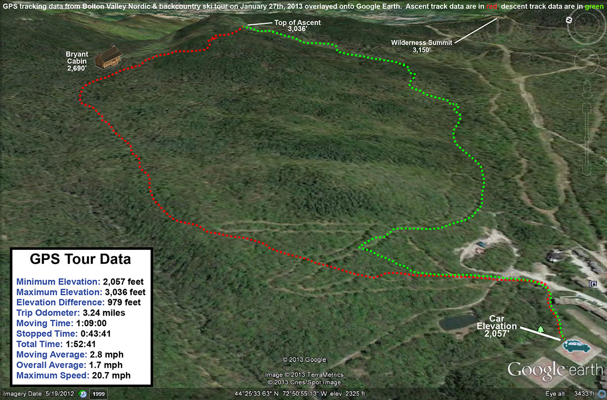
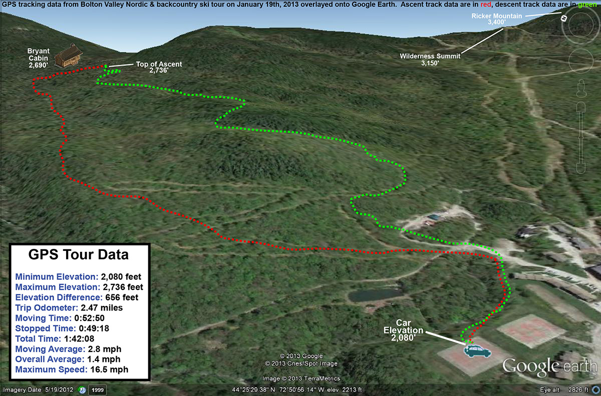
GPS tracking data for today’s Bolton Valley Nordic/backcountry tour – click for full size map
It was getting close to 5:00 P.M. before I was done with my tour, and now that we’re over a month past the solstice, I’m definitely noticing (and thankful for) that longer light. We’ve also got some warmer temperatures coming in the next few days, with a dramatic change in the weather pattern this week. A storm is coming in tomorrow that is forecast to deliver a modest 2-4” type of snowfall, but that is going to feel like a lot after only arctic dustings over the past week or so. We’re also expected to go above freezing with the next round of the storm as it cuts to the west, but hopefully we’ll get some additional snow on the back side. We could be into a more active pattern going into next weekend, which would be nice to build the snowpack after these January doldrums. With that said, I’ve certainly got a new found respect for what these arctic weather conditions can do for the snowpack, so if we do get another round of that weather, the skiing could be good as long as we can get at least some snow to go with it.
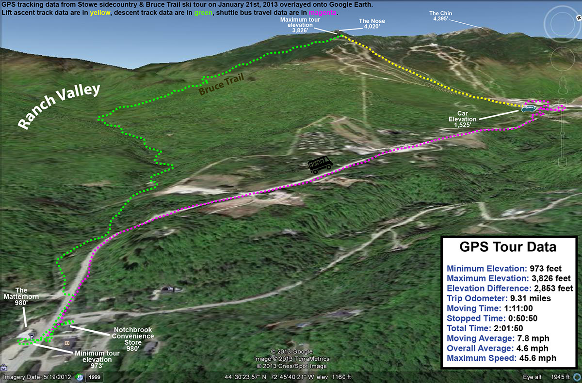
Some of the Northern Vermont ski areas have picked up close to (or in the case of Jay Peak, substantially more than) a foot of snow in the past seven days, and while that’s actually a fairly modest pace for snow accrual in the mountains this time of year, it’s helped to get surfaces back to packed powder since they hardened up last week. The snow has generally been dry and fluffy, so even with all that accumulation it hasn’t been a thorough resurfacing for all slopes. However, my explorations Saturday on the Bolton Valley Backcountry Network revealed that the powder is building and there are some nice turns to be had. Temperatures were expected to be in the single digits in the highest elevations today, so it seemed like a good opportunity for some sidecountry exploration instead of riding lifts. And, since Claire and I have been talking about bringing our Stowe ski group for a trip on the Bruce Trail one of these days, this seemed like an excellent opportunity for some reconnaissance. There’s no doubt that everyone in the group is ready for the skiing on the Bruce, but I still wanted to familiarize myself with the route to ensure that the trip would go smoothly with all the boys in tow.
“In general, I found 6 to 7 inches of powder down to the 2,000’ elevation, and at some point below there it dropped down more toward the 5-inch range.”
Temperatures hovered right around 10 F all the way to the base of the resort, and there was sun and no wind, so it wasn’t feeling too frigid at the point. The resort had snow guns going on various trails, no doubt taking advantage of the temperatures to bolster base depths that were probably brought down a bit by the warmth earlier in the month. I rode the Fourrunner Quad with a guy who had already been out for some runs, and he said the conditions were quite good. Listening to the turns of the skiers below us, it did sound pretty quiet. I could see the occasional icy spot, but the surface seemed to be mostly packed powder just as the snow report had indicated. The snow over the past week has definitely been having an effect in terms of softening up surfaces.
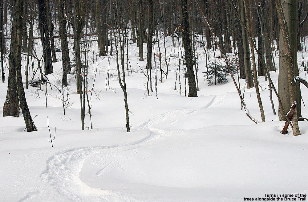
“While I’m sure the steeper top sections of the Bruce are great with a good dump of snow, the skiing today was far superior once I got down out of the evergreens and into the hardwood forest.”
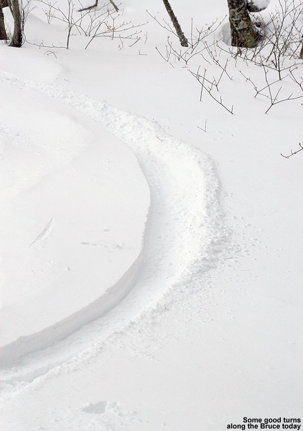
From the quad summit I headed over to the top of the Bruce Trail – a few tracks indicated that some skiers had already skied it today, but I dropped in via an alternate entrance to get an untracked line. The line was pretty steep and I was definitely touching down on the subsurface, but I could tell that I’d be able to get in some good powder turns on some lower angle terrain. The top part of the Bruce wasn’t really all that inspiring today – it’s pretty steep, a lot of pitches face southward, and it’s narrower than I’d thought it would be. I’d say it’s only 10 to 12 feet wide on average in the upper sections, which means that in reality it’s going to be tracked out and packed down after just a few skiers hit it. With its somewhat southern aspect making for spots of poor coverage here and there, it skied even narrower today. The snow was generally skier packed, so my fat Telemark skis were indeed feeling slow edge to edge, and I had to throw in a good number of alpine turns to fit in some of those small spaces dictated by the trail width and coverage.
Catching turns down in the lower elevations among the hardwoods
While I’m sure the steeper top sections of the Bruce are great with a good dump of snow, the skiing today was far superior once I got down out of the evergreens and into the hardwood forest. The trail is notably wider in that area, and there are a lot more glade options for venturing off the sides of the main route. In general, I found 6 to 7 inches of powder down to the 2,000’ elevation, and at some point below there it dropped down more toward the 5-inch range. All those depths were definitely enough for some nice powder turns on moderate angle terrain though. With the narrow nature of the Bruce Trail in the top sections, it’s really not a trail that’s going to offer up much in terms of fresh powder, so those looking for a sidecountry experience with real untracked snow would probably be best served by using the Bruce as a jumping off point for explorations of the Ranch Valley. The snowpack isn’t even especially deep right now (right around the 40” mark), but I could see a multitude of ski options all around during my descent. I noted a couple of potential areas for exploration up in the evergreen areas, but choices really exploded once down in the hardwoods. It would be easy to make a day of it out there, or, ski the resort in the morning and then tour out in the Ranch Valley in the afternoon and finish off the day by skiing out to Route 108.
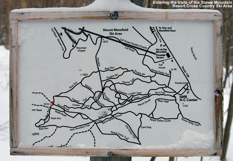
Stowe XC Map – Click for full size image
At around the 1,500’ elevation, I entered the trails of the Stowe Mountain Resort Cross Country Ski Center. This is the part I’d been concerned about in terms of making the correct choices to get out to Route 108 and the Matterhorn. It turns out that it’s much easier than I’d thought; you simply stay on the Bruce, and Burt Trails, following the signs that say “Ski Lift”. Even though you may not be planning to head back to the Toll House Lift, those “Ski Lift” signs are the way to go. Eventually you’ll get to a junction where following the “Ski Lift” route is a very obvious (and somewhat arduous looking) uphill, so you won’t want to go that way. By that point there are signs that indicate “Route 108”, and those will get you right out to the Matterhorn area. At every intersection you essentially go straight through, so in a worst case scenario, go with that. The trek through Stowe’s Nordic trails, and a small portion of the trails that belong to the Trapp Family Lodge Cross Country Ski Center, is slightly downhill, but there’s plenty of poling and skating to be done. I was happy to have my Telemark gear, even if I looked funny with my skis being three times the width of the other Nordic skiers ambling around on the trails. I generally took it slow and enjoyed the scenery, which included some marvelous views of the Ranch Brook. The brook had that winter look with some flowing water, but also lots of ice, and snow pillows covering the rocks.
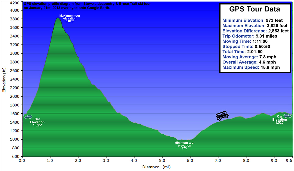
Elevation profile of today’s tour – click for full size image
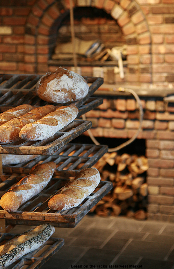
The final leg of the descent on Ranch Brook Road brings your right out on the “Ski Inn” driveway, next door to the Matterhorn, and across the street from The Notchbrook Convenience Store. I had time before the next uphill Mountain Road Shuttle arrived, so I stopped into the Matterhorn to get some sushi… only to discover that they don’t have sushi on Mondays. Clearly I’m going to have to hit the Bruce again with the boys on a different day so that we can finish that part of the adventure. So instead, I popped across the street to the store and got a snack before catching the shuttle back up to my car in the Mt. Mansfield lot. One thing I should note about the shuttle – the ski slots on the outside are still fairly old school, so if you’ve got fat and/or twin tip skis, you might have to bring them on the bus with you. Apparently that happens a lot, because the driver immediately knew what my issue was when I inquired. Missing out on the sushi, I did stop off at Harvest Market for a couple of samosas on the way home, and that definitely filled the void. So, today’s outing offered up some good turns in the powder, and was certainly a successful reconnaissance. The route down to the Matterhorn is easy, and I can tell that the biggest hurdle is going to be getting the boys through the flatter terrain at the end of the run. If that’s the toughest part we have to deal with though, it should be a lot of fun.
Harvest Market
Weather-wise, the day turned out much warmer than the forecast seemed to suggest – it was 20 F once I was back down in the valley, and before I’d realized that, I couldn’t figure out why it felt so comfortable. The sunny skies from earlier in the day had clouded over ahead of another small snowfall event that’s supposed to hit us tonight into tomorrow – these are the sorts of storms we’ve got for now until something bigger comes along, but at least we’re getting something.
Today’s Tour viewed in Google Earth – Click for full size image
Heading off into the powder below North Slope today
It was a lot of fun skiing in the soft snow and warm temperatures last weekend, but winter is definitely back now. Temperatures dropped down closer to seasonable levels at the beginning of the week, and then the bottom fell out toward the end of the week as we dropped below zero F Thursday night with an arctic frontal passage. Fortunately, we’ve also had some modest shots of snow to start freshening the snowpack, and temperatures were back up to around 30 F in the mountains today, so it did seem like a good opportunity to get out for some turns and exercise. Stowe is reporting 8” of snow since Wednesday, and the skiing looks great based on the pictures that Powderfreak posted in the ski thread and the Northern New England thread at the American Weather Forum today. Bolton Valley is also reporting 5” of new snow during the period. Although I’m thinking of waiting until we hit roughly the one foot mark before checking out the lift served terrain, it did seem like we’d seen enough new snow in the past few days to provide some decent backcountry turns.
“…I found 3 to 4 inches of fluff down at the Village level, and that gradually increased to the 4 to 6 inch range by the time I got up to the Bryant Cabin at around 2,700’.”
With all that in mind, I decided to hit the mountain for a quick tour up to the Bryant Cabin and back through whatever terrain seemed fitting for the conditions. We’d reached the mid 30s F down at the house (495’) when I headed out around 2:00 P.M., but up in the Village at 2,100’ it was just 31 F. There certainly hasn’t been enough snowfall yet to really resurface the slopes and get the on piste conditions back to normal, so I couldn’t believe how the Village parking lots were virtually full. I wasn’t even able to get a parking spot in the upper tennis court lot like I usually do because it was full, but the lower tennis court lot had a decent number of spaces, and I was still able to park trailside along Broadway. The resort was hopping though, so I guess the holiday weekend and the comfortable weather are enough to make people really want to get out there. Overall that’s great for the resort of course.
“Indeed the turns in the powder were silky, especially when aided by the width of my AMPerages, and it was nice to feel that float again.”
In terms of unconsolidated snow above the old base, I found 3 to 4 inches of fluff down at the Village level, and that gradually increased to the 4 to 6 inch range by the time I got up to the Bryant Cabin at around 2,700’. Coverage on the Bryant Trail was generally fine, although a couple of the stream crossings had only recently filled back in after presumably being blown out a bit with running water during the warm spell. Traffic out in the Bryant area was pretty light once I was up above the Nordic trails – I saw a couple of skiers descending and a couple groups coming down on snowshoes. The air was generally calm, although you could occasionally hear some gentle gusts of wind up in the peaks. We’ve got another system and arctic frontal boundary coming through tomorrow, so there was that feeling of being between systems.
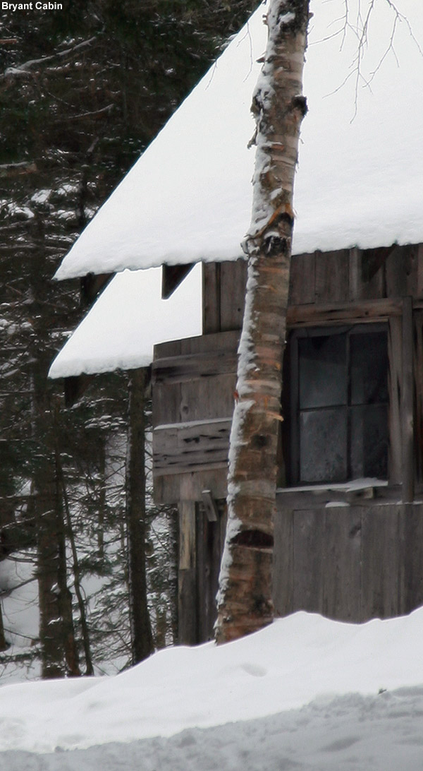
Bryant Cabin
There was nobody in the Bryant Cabin area when I arrived there, and it was very quiet as I made my way past and stopped at the top of Gardiner’s Lane. I could see some of the glades above me, and the look of the powder up there was very appealing, but I could tell by the tracks of a couple of other skiers up there that the new snow wasn’t quite deep enough to really make the turns bottomless. As I was stripping off my skins, I heard a little noise coming from above me in the Birch Loop direction, and soon another backcountry skier passed by and headed down Gardiner’s Lane. I’m not sure what he’d been skiing up above, but he probably had a similar plan to mine for the terrain below – there are a lot of nice mellow options off Gardiner’s Lane that would work really well with the conditions.
The powder is building.
Conditions on Gardiner’s Lane were packed, and a little bumpy in spots. At the junction with North Slope, I headed up a bit to catch a nice mellow line that I knew, and I’m glad that I did. I could see that another skier had taken in before me, and the tracks left behind suggested some nice turns. Indeed the turns in the powder were silky, especially when aided by the width of my AMPerages, and it was nice to feel that float again. Back on Gardiner’s Lane, I had a feeling that I was in the zone of another glade I knew, and figuring that Gardiner’s Lane itself would have seen a fair share of traffic, I decided to head on that lesser used route. Only one other skier had passed through there, and the snow was good, but the pitch was too steep to avoid contacting the base snow. Below there I followed a set of tracks to an area I’d never been, and found a nice long glade that brought me all the way back down to World Cup. It’s got to be one of the longest glades I’ve seen out there. I’m not sure how new it is in the grand scheme of the backcountry network, but it’s new to me; I can’t wait to show it to E and the boys – especially with deeper powder. Someone did some nice work in there. The glade starts off with some mellow terrain that was great for today’s conditions, and then it steepens out to more of an intermediate pitch. I was even able to finish off with a run on the Telemark Practice Slope, which did have some irregularities in the subsurface snow due to previous skier traffic, but still delivered some nice turns – even a few in which I was able to stay floating in the powder.
GPS Track of today’s tour on Google Earth
Overall I’d say that that part of the run in the new glade was a good description of the general conditions out there – you can get some bottomless turns (especially with the help of fat powder boards) on the mellower green-style terrain, but on intermediate pitches and above you’re going to be touching bottom a lot. It was definitely worth a tour out there today though, and if we get a few more inches as the next system passes through tomorrow, it’s going to be even better.
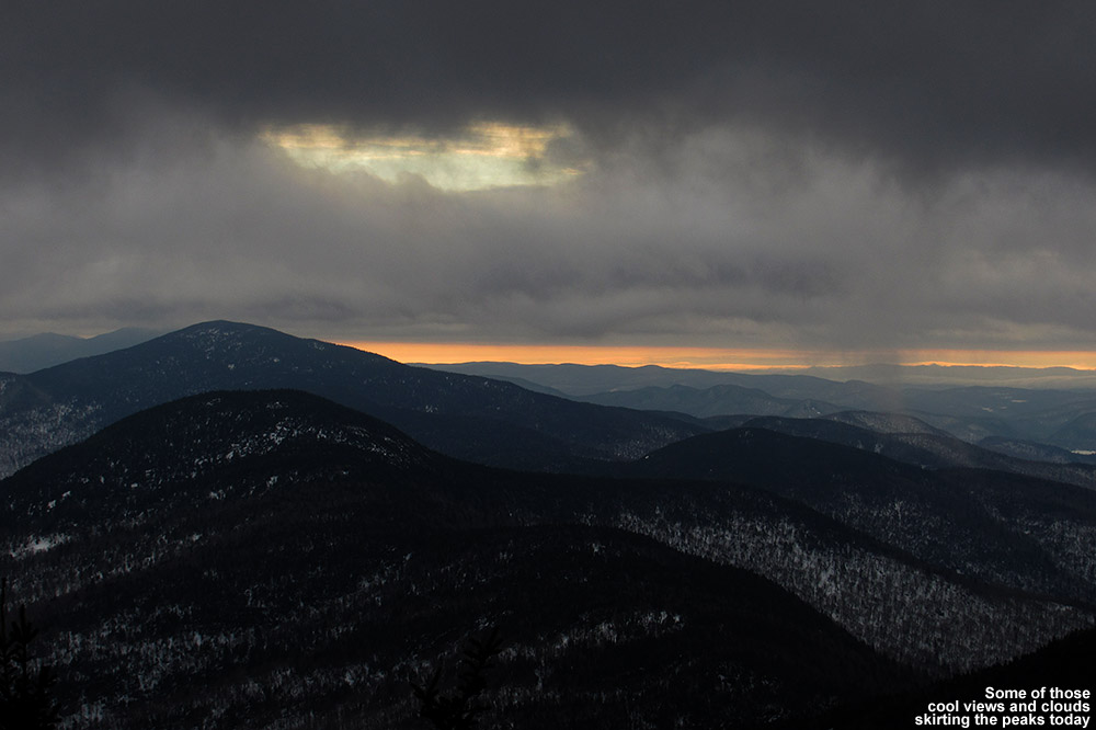
The clouds put on quite a show today throughout the mountains.
With a generally cloudy forecast, I wasn’t sure if today’s skiing at Stowe was going to match up to the quality we experienced yesterday at Bolton, but boy did Mt. Mansfield deliver. Temperatures did get down to the freezing point overnight, but the morning clouds in the valley were an undercast that meant sunny skies in the mountains. Any snow that might have cooled down and tightened up was certainly soft by the time we arrived around midday. There was some exciting weather out there as well. Higher clouds had built in from the south, and screaming winds in the higher elevations of the atmosphere had them cruising along at impressive speeds not to far above the summits. Temperatures were schizophrenic too, with hot and cold pockets all over the place. On my first run of the day on the Sunny Spruce Quad, after we’d risen about 1,000’ vertical or so, we suddenly got to a warm layer of the atmosphere – the temperature felt like it changed 10 F instantaneously.
“You could attack anything, as steep as you wanted, and that snow would just peel away beautifully and let you hold those turns.”
We kicked off the day on Spruce Peak, and Luke had a little trouble with the RFID on his season’s pass that required the lift operator to call in some technical help. That gave us time to meet up with Claire though, once she’d taken care of her duties and gotten the program coordinators their passes. Conditions on Spruce Peak were generally nice, but there were certainly some bare spots opening up on natural snow terrain since it’s generally south-facing. Everything was soft, with the best surfaces being those that had seen various combinations grooming, skier traffic, or manmade snow. Natural snow terrain that hadn’t seen any packing was skiable, but typically mushy or sticky. I found turns down West Slope this afternoon particularly invigorating, as you could lay your skis over as far as you wanted on that steep pitch and have that snow just peel away as you carved it up.
“Hanky style”
After a few runs on Spruce, we took a quick pit stop at Spruce Camp where Claire and Luke gabbed some bagels that they hadn’t had a chance to eat earlier, folks got drinks if they needed them, and then we shifted over to Mt. Mansfield. With back to back gondola rides to get up to the Cliff House, there was plenty of time to take in snacks, but since not everyone had food, we decided that we’d also go for some food at the Octagon. From the top of the Gondola we headed down toward the Fourrunner Quad via Cliff Trail, and with all natural snow, there were some sticky spots, especially where traffic was lowest. You could really feel the difference in the snow surfaces when we arrived at Nosedive though, since it has a good amount of manmade snow and sees a lot more traffic; there were no issues with sticky snow there. At the Octagon we got some food, hung out for while, and everyone had a good recharge. As it turned out, we were all going to need that recharge, because we were going to work ourselves hard for the rest of the afternoon.
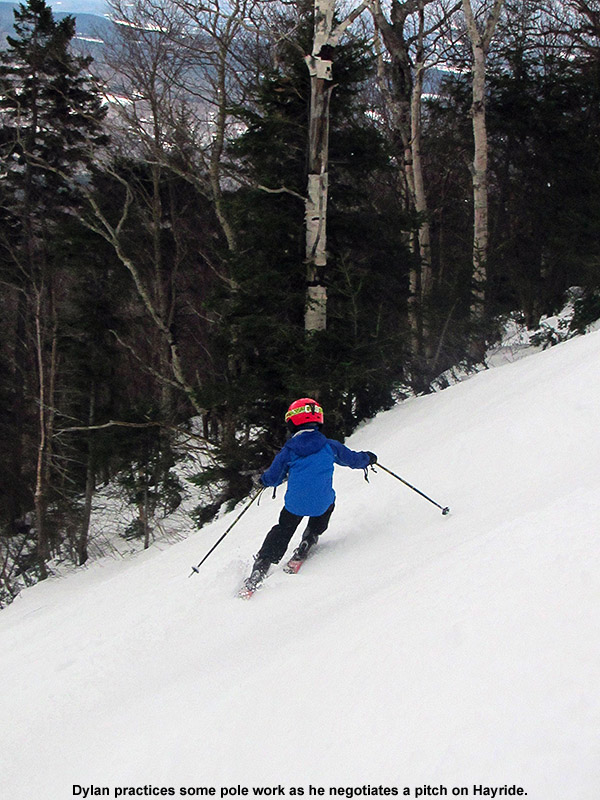
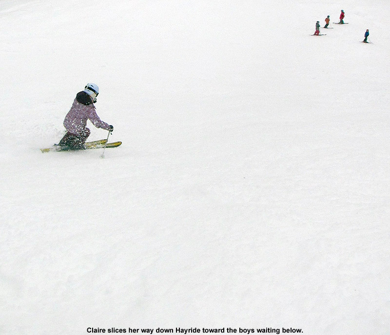
Working on those poles today on Hayride
Luke had originally requested a trip to Nosedive Bypass, since it’s one of the mountain’s areas that he’d yet to ski, but we were unsure of how much traffic it had seen, and how easy the skiing would be. Instead, Claire and I decided that it would be a perfect time for the boys to work on their bump skiing. The snow was just so good on that type of terrain that we didn’t want to pass up the chance, so we headed to the top of Hayride and Centerline. We could see that both were loaded with tons of soft, fantastic looking bump lines, so it was a difficult decision, but we ultimately went with Hayride. It turned out to be a good choice because there were also those extra steep pitches that let the boys work on steep skiing technique. The bumps were excellent, and the snow quality was fantastic even on the steepest pitches. You could attack anything, as steep as you wanted, and that snow would just peel away beautifully and let you hold those turns.
Although the boys were all ripping up the terrain, and it was hard to nitpick on instruction, I could see that they needed some pole work. The combination of bumps and steeps was perfect ground for demonstrating how proper pole technique can really bring you to that next level of skiing in that terrain. Reaching for those pole plants on steep terrain can really keep that upper body facing downhill, so we kept pushing that upper/lower body disconnect because I could see that some of the boys couldn’t manage turns in the tighter lines like they’d want to. It’s really difficult to make rapid transitions back and forth and perform those especially tight turns if you upper body is constantly turning out of the fall line. I’d say Ty has got that down the smoothest of all the boys, and for some reason it’s just something he picked up when he was very young, but as a group I think it’s a process that will really reap rewards for the boys this season. They’ve all definitely reached a level of skiing where they can handle whatever terrain you throw at them, and it’s time to work on the finer points of body positioning.
Claire showing the boys how it’s done
After a couple of trips on Hayride, we finally mixed it up and visited Centerline, which of course yielded more fantastic bump lines. That let us head south to pick up the rail park, since Dylan was really looking to get into some park terrain. They had some long rails and boxes in there, and the funniest moment by far was when Dylan was skiing along a double box, and near the end of the second one, which was probably a couple feet wide, he ended up with a ski on the ground on each side. He continued to ride it, in classic “crotch grind” fashion, and held on right through. It was as impressive as it was funny, and the “crotch grind” definitely hung with us for the rest of the day. We met up with Connor’s group right at the end of the park, and we had a good collective run down Tyro. We didn’t want to do it, but the boys convinced us to drop below the Crossover back to the Gondola to catch a trip through the Half Pipe. It was a heck of a lot of fun though, and those massive vertical walls felt bigger than ever, so it was worth the extra work to get back to the Over Easy. We had really cooked ourselves pretty good with all those bumps, and I know that most everyone was enjoying that well earned tiredness at the end of the day.
South winds were screaming along at the top of the Fourrunner Quad at the end of the day, and we’re rapidly approaching the end of the warm weather as a cold front nears the area. Snow is expected by overnight tonight in the higher elevations, and by midday tomorrow in the valleys. The biggest question going forward is about how much snow Mother Nature will put down by the upcoming MLK weekend. It doesn’t look like there’s a big enough storm coming this week to put down a real resurfacing to support lift-served skiing, so it may be time to hit the sidecountry/backcountry. But, there are a number of snow chances in the upcoming pattern, and you never know when the Northern Greens will pull 6 to 12 inches out of small passing systems. I was talking with E on the ride home about how, even though we had tons of good powder skiing days in the previous couple of weeks, it’s hard to think back to it when you’re out there on spring snow. It was a good break, but it will be nice to get the fat skis back out soon.
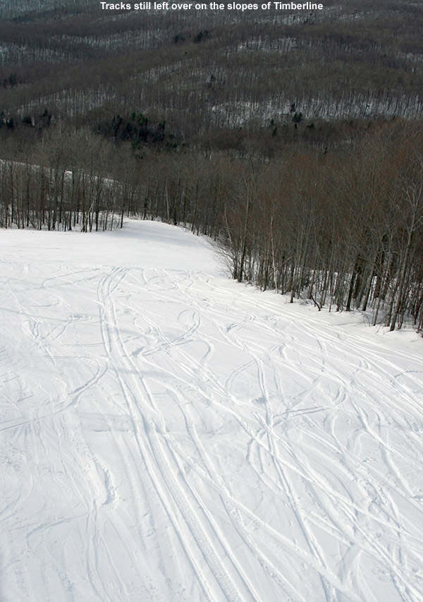
Repairs on the Timberline Quad at Bolton Valley are complete, and although I heard that it actually started running yesterday, today was our first chance to check out the Timberline area and make some turns. Forecast temperatures in the 40s F are more like March or April than January this weekend, and with no need to head out early for powder, we opted for a warm, afternoon session. When we headed up to the mountain around 1:30 P.M. or so, temperatures both at the house (495’) and up at the Timberline Base (1,500’) were in the low 40s F, and although I thought we’d have generally cloudy conditions, it was actually mostly sunny. It’s great to have Timberline and that Timberline vibe back though, we pulled in and found probably a couple dozen cars present, and I was able to drop off E and the boys and park right below the lodge. With the sun shining and mild temperatures, it was easy to think it was one of those spring Timberline outings.
Leftover tracks at Timberline
The Timberline trails were looking really sweet in the sunshine, and you could see that areas that hadn’t been groomed hadn’t even been tracked out. There were a couple of spots here and there where snow coverage was low, but they were pretty minor (aside from where a snow cat seemed to dig some holes on Showtime). I think the resort has got to be pretty happy that even the low elevation areas of Timberline are looking good with mostly natural snow. I know some snow was blown on parts of Timberline Run, but I’m sure that money has been saved on snowmaking for some runs like Showtime. I guess they could make snow in some areas going forward if they want to beef up the base for the spring. In the snow report they mentioned that there were a couple of trails closed for various reasons, but with Timberline in operation, the mountain is running at just shy of 100% open.
As they’ve often done in the spring, the boys went with their Telemark skis today to get in some practice, and the soft conditions were perfect for working on their turns. We did a couple laps on the Villager/Timberline Run route, with Sure Shot thrown in as well. Both boys went without the cables on their bindings, and while it worked well for Ty, perhaps because his new Telemark boots are stiff and supportive enough, it seemed a little sloppy for Dylan. I think his boots are worn in enough that he might need that extra tension from the cables. We ran into Luke and Claire and we were able get in some fun turns with them – Claire was definitely enjoying the ease of the Timberline logistics today as well. Everyone made plenty of soft carves in the snow today, and it looks like we’ll continue with these conditions tomorrow until things start to cool down at some point Monday. After that we’ll be looking for new snow to hopefully get back to powder conditions; it’s going to be fun to get back into some powder with Timberline in operation.

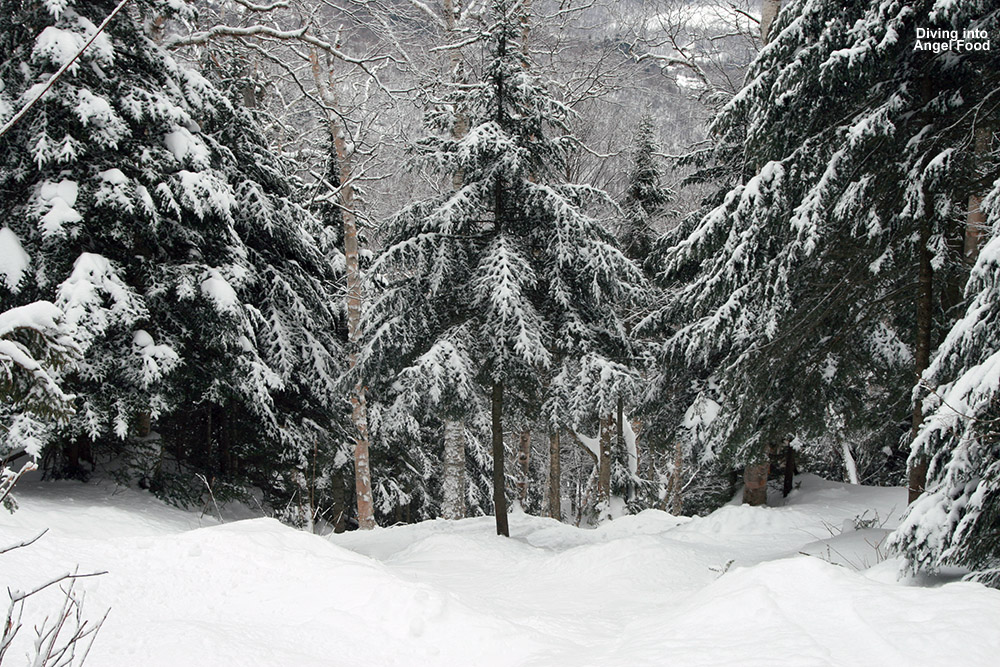
 With the combination of new snow and relatively low, midweek skier traffic, the traverse out to Angel Food was in good shape. I stopped in a few spots along the traverse to check the depth of the powder, and found anywhere from 12 to 20 inches in the high elevations. The main route was certainly tracked up, but there are just so many acres and acres of terrain around it that fresh lines were everywhere for the taking. Even though it was tracked and packed, the snow in the central areas was so good that I actually spent a lot of time there working on turns. When I did venture off the sides of the main route into other trees, the powder turns were divine, but the depth of the powder definitely started to drop as I went down in elevation. Down near the 2,000’ elevation there was also a thin layer of crust somewhere between the layers of powder. It was often quite subtle, so I suspect it was simply a bit of melt crust from when temperatures in the lower elevations rose above freezing on one of these past few days. I decided to take the traverses that got me back to the base of the resort instead of venturing down to Route 108, since that’s most likely what we’ll do with the boys at first, but we’ll work our way up to some of the other stuff. There was just glade after glade after glade off the main Angel Food route with few if any tracks, so the resort is really set up well for the coming holiday weekend.
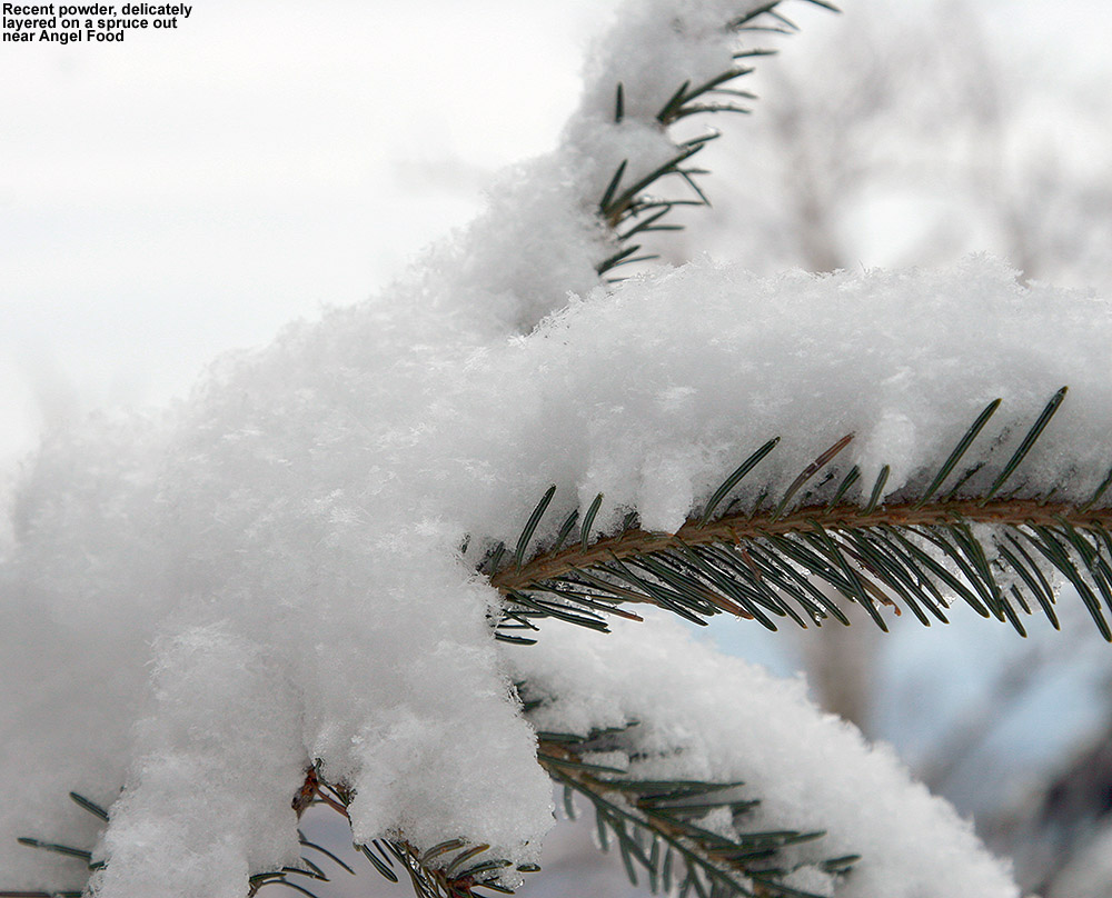


