Bolton is starting off this storm cycle with about a foot of powder to greet midweek visitors.
By the time I’d left the house (495’) at 7:30 A.M. this morning, we’d picked up 0.6 additional inches of snow since the 6:00 A.M. snowboard clearing, bringing the event total to 4.1 inches. It had been snowing lightly at the house when I left, but when I arrived up at the Bolton Valley Village area (2,100’) it was snowing moderately and still accumulating. The mountain had reported 7 inches of new snow as of their 6:45 A.M. update, but I suspected I’d find a bit more based on the way it was coming down. The lifts weren’t going to start loading until 9:00 A.M., so I kicked off the morning off by skinning for some turns, taking the route straight up Beech Seal. I first checked the consistency of the snow near the base area; I couldn’t quite make a snowball out of it in my hand, so I guess I’d describe it as medium weight powder. Beech Seal had been groomed at some point earlier, but I found about 2 to 4 inches of additional new snow on top of the groomed base.
“…today Spillway offered up some gorgeous steep powder.”
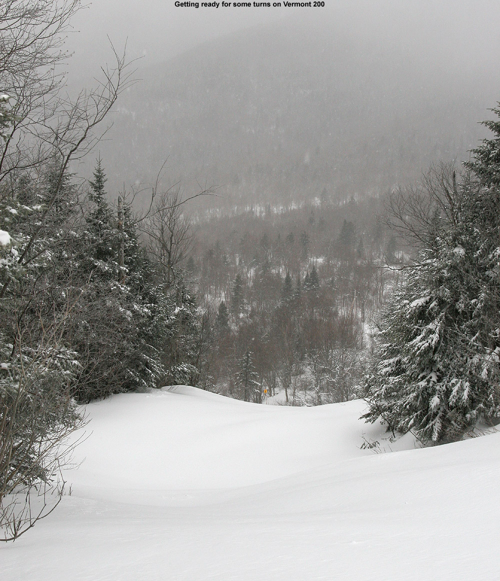
When I reached mid mountain (2,500’) I checked the depth of the powder in an undisturbed location and it came in right at 12 inches. That should represent the combination of powder from last week’s midweek system (~6 inches) as well as whatever had come down up to that point with this new event, so that seemed reasonable. Wind doesn’t appear to have been much a factor with this system, so getting measurements was easy. I was thinking of skinning up in the Cobrass area, but there was enough powder to keep me following one of the snowmobile tracks for my ascent. At about 9:00 A.M. I’d reached the top of Vermont 200 (~3,000’), and when I checked the depth of the new snow there I found that it was at 9 inches.
“It was really nice to see all the visitors getting rewarded with such a splendid day on the slopes.”
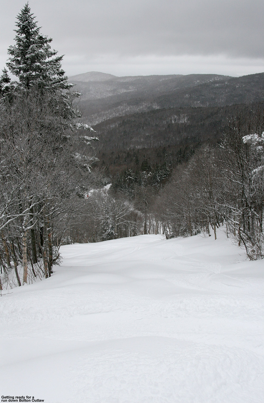
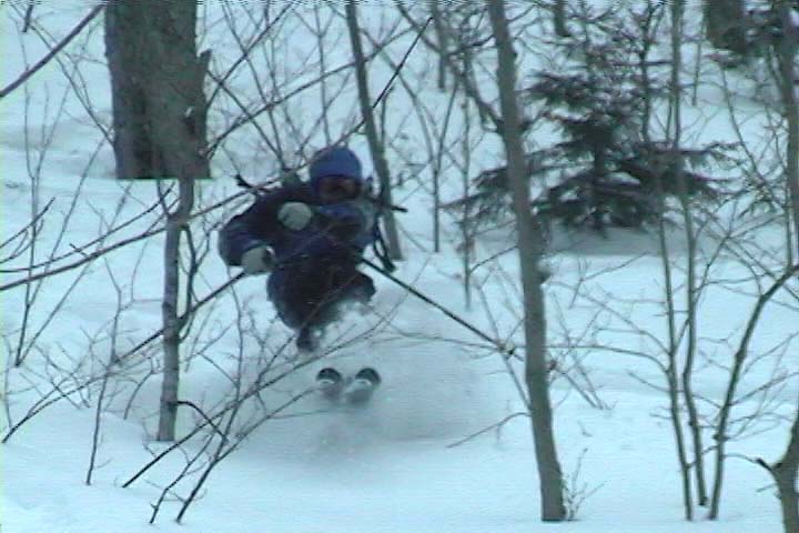
I enjoyed first tracks down Vermont 200, and this new round of snow had settled in nicely. The medium-density powder was just what the doctor had ordered in terms of getting the windswept steeps back into shape. I was on my Telemark skis, and found that the consistency of the snow made for really easy turns. After my initial descent I stayed around for some rides on the lift, and unquestionably the trail pick of the day for me was Spillway. Usually I avoid it like the plague between its man-made snow, exposure to the wind, and traffic, but today Spillway offered up some gorgeous steep powder. The fact that it has seen grooming in the past made the subsurface the most consistent and provided lots of nice bottomless turns, and since there didn’t appear to be much wind with this event, there were no issues on that front. I had to hit it twice because it was so good, and I’d say it was better than even Hard Luck or Vermont 200. The Wilderness Lift opened right around 10:00 A.M., and I was fortunate to catch one of the first few chairs. The way the steeper trails had been skiing so nicely, I opted for Bolton Outlaw from the Wilderness Summit, and it was in great shape. After that descent I traversed back toward the main mountain. I followed a random set of tracks off New Sherman’s Pass and found a nice region of glades that I’d never explored before.
Things were looking great on Bolton Outlaw today
The mountain definitely had more than its usual midweek handful of people this morning. A lot of the extra folks I saw were children, and I think some of the schools in the Northeast have vacation right now because I heard what sounded like a Boston-style accent on a couple of occasions. It was really nice to see all the visitors getting rewarded with such a splendid day on the slopes.
The moderate snowfall had gradually tapered off through the morning, and when I left the mountain around 10:40 A.M. there was just light snow and the temperature at my car (~2,100’) was 34 F. The temperature stayed fairly stable through most of the descent down the Bolton Valley Access Road, but at the bottom (340’) it was up to 35 F. The precipitation was light snow as I drove westward through the Winooski Valley to the center of Richmond. The temperature there was up to 36 F however, and I was surprised to see that Richmond appeared to have picked up little if any snow from this event. When I’d reached the I-89 rest area in Williston, the temperature was up to 37 F and the precipitation was over to rain, which was coming down at moderate intensity for a while. In the South Burlington area the temperature was up to 38 F, and when I finally arrived at the UVM campus it had hit 39 F.
Bolton Valley was officially reporting 8 inches from this event as of their 10:05 A.M. update, so I don’t think we’ll have any trouble getting into Scott’s 10-20” inch prediction range with some upslope. It sounds like this is one of the best upslope setups we’ve seen this season, so it should be fun to see how it plays out for the mountains and even the mountain valleys over the next couple of days. It’s expected to start up tonight so I’ll certainly report on whatever makes it down to our elevation in Waterbury. Images from today can be found in the gallery below, and full size versions are also available in the report to SkiVT-L from today.
Dylan exploring the powdery terrain in the Wood's Hole Glades
Although it was a holiday today, E and Ty had to go to school, leaving Dylan and I home alone. After a couple of sunny days, the weather was mostly cloudy with flurries throughout the day at the house (495’), and it was a little tougher to get inspired to head up to the hill. I got a lot of stuff done at home during the day, and when I asked Dylan if he wanted to head up to the mountain for a couple of runs, he was very excited… click through to read the full trip report and see all the images from the day.
Ty squiggling some tracks into the powder on Five Corners
As we approach the Christmas holiday, snowstorms are really stacked up for the Northeast. Storm #1 came through on Wednesday and Thursday (December 17th & 18th), dropping 7.1 inches at our location in Waterbury (495’), and before storm #2 had even arrived, we picked up another 1.6 inches from a frontal passage on Thursday evening. Storms #2 and #3, were expected to pass through over the weekend (Fri/Sat and Sun/Mon respectively), and looked to be even bigger, although storm #2 was initially expected to be more of a Central/Southern New England Event.
Ty and I headed up to the mountain today to cash in on the new snow. We arrived in the Bolton Valley village (2,100’) to a temperature of 5 F, but it eventually warmed up to around 20 F, the sun came out, and we were rewarded with an awesome powder day. A great part of the day was having lunch in the James Moore Tavern while we watched people ski the powder in the terrain park. An even better part of the day was finishing up lunch and then hitting those powder lines ourselves! Ty got to ski a lot of untracked snow today and I could see that his powder technique continues to improve. Check out all the pictures and details in the full report from today.
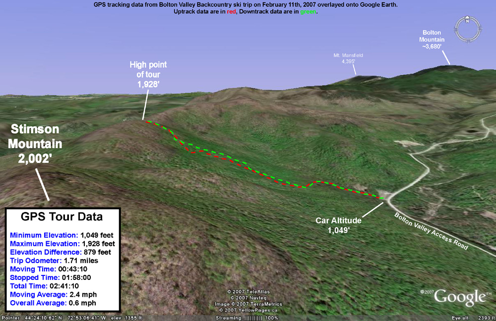
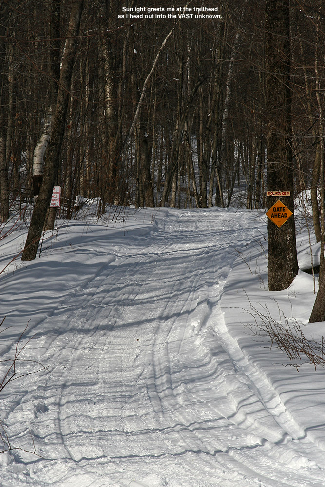
Today I headed out for some backcountry exploration in the Bolton area. I was sure that James would still be resting his ankle, so once again I made it a solo outing. After exploring part of the Cotton Brook drainage the previous week, I decided to switch it up and check out something on the other side of the valley. A convenient starting area for reaching the terrain on the western side of the valley is one of the VAST (Vermont Association of Snow Travelers) access points. The ample parking lot sits at an elevation of roughly 1,000 feet on the Bolton Valley Access Road. My plan was to start out on the VAST trail that heads west from the parking area, and make my way up to the ridge line that extends north from Stimson Mountain. The summit of Stimson Mountain is at 2,002 feet, and the ridge maintains roughly that elevation for several miles as it heads northward toward the Bolton Mountain area. If I was able to find a suitable route to the ridge, and the terrain was appropriate, the tour would provide about 1,000 vertical feet of skiing.
I arrived at the trailhead in late morning to sunny skies and a temperature of 19 degrees F. There was only one snowmobile trailer in the lot at that time, so the lot looked pretty deserted. I started skinning westward on the nicely maintained VAST trail, which at first had a fairly gradual slope. Then, I crossed a large bridge, and the trail steepened. After maybe 50-100 vertical feet, the trail flattened out and turned to the south. At that point I decided to break away from the VAST trail and head westward up the ridge. The going would be slower once I had to get off the trail and break my own way through the powder, but as far as I could tell without a VAST map, the VAST trail headed more southward and was not going to get me up the ridge where I wanted to be. I finally broke off the VAST trail at the intersection with an old logging road. There was a sign indicating that the logging road was not open for VAST travel.
Despite breaking my own trail, the going was pretty smooth. I’d checked the depth of the powder just after I started my hike, and found it to be 9 inches over whatever thicker layer was below it. At the bottom of the logging road, the snow was still in the 9-12-inch range, so I wasn’t bogged down by too much depth. I continued upward, following a network of logging roads and taking the route that seemed to best direct me toward my destination on the ridge. I spied plenty of great ski lines along the way, and I marked a few of the more attractive ones on my GPS. The logging road seemed to have been maintained and it made for quick travel; at least it appeared that way with the snowpack at the time. If there was a forest of saplings growing on the road, they were long buried under the snowpack. There was only one obstacle that forced me to detour from the logging roads, a huge tree that lay across the trail near the middle of the hike. It took a few extra minutes to work my way around that one. Currently, with the additional 3 to 4 feet of new snow from Wednesday’s storm, that tree is probably not even an issue.
My route took me generally westward up the ridge, with a bit of northward movement toward the end. About 2/3 of the way through the hike, I came across a large flat area, and above it was some of the steepest terrain I’d seen on the day. The terrain there actually looked a bit too steep and rocky for skiing, so the slight northward trend worked well to keep me in more skiable terrain. Near the top of the hike I attained nice views of the Timberline area across the valley. I could even hear the announcer for the ski race that was taking place over there. The race was presumably a continuation of the event that Ty and I had seen the previous day. High clouds had been building in throughout my trip, so at that point the sunshine was no longer as brilliant as it had been when I started the hike.
After several minutes of additional climbing, I finally hit the ridge. While the powder just below the ridge had built up to a depth of around 15 inches, on the ridge itself, the snow was heavily compacted and drifted. In some places, the snow had been scoured down to just a few inches in depth. Small trees all across the ridgeline had been bent over and snapped by the strong prevailing winds that raked the area. To the west below me was Bolton Notch, and I could see what looked like some skiable lines dropping eastward toward the Bolton Notch Road. I actually thought I heard the voices of a couple of people below me in the notch, but it was very faint and I couldn’t get a fix on their location. I hiked around the summit ridge for a bit while I had a snack and a drink, then removed my skins and started down.
To ensure that I’d be able to get right back to the car without having to do any hiking along the access road, I followed a downhill route in the same general area as my skin track. Sometimes I traversed out above my skin track and skied back down to it, but for much of the run I was able to stay off to the skier’s left of my skin track and follow the natural contour of the terrain. Even with the snowpack below average (as gauged by the snow depth at the stake on Mt. Mansfield being at only ~54 inches), one could pretty much ski anywhere in the area I explored. There were always some lines that seemed to be the pick of the crop, but there were few areas where the vegetation was too thick for turns. There was plenty of powder for bottomless turns throughout the descent, and the depth of the base let me tackle the lines with a fair degree of confidence. With the potential for 3 to 4 feet of snow from the storm this coming Wednesday, I suspect there will be even more wide open lines. A storm of the size expected would likely bring the snow depth at the Mt. Mansfield stake close to 80 inches, which would actually be above average for this time of year.
For the final pitch down to the VAST trail, I actually skied the last part of the logging road I’d ascended. It was steep enough that it made for some pretty nice turns. The Avocet recorded 920 vertical feet of descent and the Suunto recorded 958 vertical feet of descent, a difference of 4.0%. The high clouds had continued to build in throughout the tour, so the temperature at the end of my run was pretty much the same as it had been when I started skinning. It was a fun and easy trip with great access.
Well, our 7th valley snowfall of the season delivered nicely, at both the low and high elevations. When I did my first snow measurement this morning at around 9:00 A.M., we already had 2.6 inches of new snow at our place in Waterbury (elevation 495 feet), and the snowfall showed no signs of letting up. We headed up to Bolton Valley for some skiing and they already had 4 inches of fresh powder to start the day. It continued to snow all day up at Bolton and they’re now reporting 7-10 inches of new snow. It was a full on powder day, and the ski patrol was opening natural snow trails all over the place. We only got a chance to ski one of the natural snow trails (the “Glades” trail off the Mid-Mountain Lift) since we were with the boys, but it was more than ready to be opened. There was easily a foot of powder on top of denser base-layer snow below, so you didn’t really have to worry much about rocks. I’m sure most trails could be opened at this point if the mountain wanted to do it. The Northern Vermont resorts seem to be reporting new snowfall totals in the 6 to 12-inch range from this event so far, so I’m sure more natural snow trails will be opening soon. We arrived home to 4 more inches of snow at the house and it was still snowing. I’m estimating the water content of the snow in the 6-8% H2O range here at our place. With this event (6.6 inches so far), we’re up to 21.6 inches of snowfall on the season here. There were also 8 new inches of snow at the Mt. Mansfield Stake, and the snow depth there is now up to 22 inches. Tomorrow is supposed to be sunny, and with all this fresh powder the backcountry/sidecountry is certainly open for business. I’m definitely planning to earn some turns and get some photos.
Trip report
It’s interesting that all the new snow didn’t really come from a very official “storm”, but the local meteorologists gave us a good heads up so we were able to plan our day accordingly. We knew we were heading up to Bolton for some turns, but we wanted to pick the time of day to go with the boys and make the best use of the new snow. Initially, we thought it might be best to let the snow accumulate and head up to the slopes in the afternoon, but when we woke up to almost three inches at the house in the morning, we decided to get skiing as soon as possible.
The drive was a little sketchy with the continued heavy snowfall, and we even had to stop a couple of times on the way up the Bolton Valley Access Road. The first occasion was to let a rafter of wild turkeys cross the road. E counted at least 18 of them, but said some had already disappeared into the trees before she had a chance to count them. The second stop was for a car that was slipping its way up the last steep section of the road. Perhaps they hadn’t put on their snow tires yet, but they eventually gained enough traction and let everyone make it up to the Village. Once again, there was a huge crew of Bolton Valley associates ready to help us with our ski gear in the Village unloading area. We were doing well in our unloading process and didn’t want to take them away from helping other guests, but we thanked them anyway. I’m not sure if this is just something they do over the holidays, or if is standard customer service now, but it’s a nice touch. It’s as if they’ve infused a touch of Deer Valley into Bolton Valley. I had a chance to chat with the Bolton Valley associates and they commented on how great it was to have all this snowfall with virtually no wind. I guess that’s what you can get from a “non storm” type of snowstorm. They were also hyping the fact that Sunday was supposed to be a beautiful sunny day. In the back of my mind, I appreciated the fact that such a day would make for fantastic skiing in all the new powder, and even better photography, but at the moment I was more concerned with the fact that it was dumping in the here and now.
With four new inches of snow in the Village already, we wasted no time suiting up and getting right on the Snowflake Lift. The snow surface was cut up powder in the center of the trails with plenty of untracked along the edges. We skied with Dylan between our legs again, and boy was it a lot tougher in chowder and powder than on a nicely manicured slope. His skis would submarine in the powder and pull him down, so I basically had to hold him high and keep him floating on top of the snow in the more powdery areas. It was even more work than usual, but he seemed to be pretty happy with the whole experience so it was worth it. Dylan was even keeping his mittens on, which was nice to see on such a snowy day. On one of our early runs, Ty and I showed Mom the terrain in the Sprig O’ Pine/Deer Run area where we like to scout for powder, but this terrain was just too mellow for the accumulating snow. The slow progress in this area did give us a chance to get a picture of Dylan standing in the powder and all suited up in a combination of his new gear and some of Ty’s old stuff.
We did a couple of runs in our usual haunts off the Snowflake and Mid-Mountain lifts, and got to show Mom our little powder stash under the Vista Quad. Then, circumstances arose that led us to try something new. While riding the Mid-Mountain lift, I began noticing skiers filtering out of the trails to the skier’s right of the lift (terrain over in the “Glades” area). I initially thought these folks might be poaching, but there were just a few too many of them for that to be the case. The patrol must have actually opened some of these trails. I’ve skied the terrain in that area before, and some of it rather steep and contoured. So, I was really skeptical that it could be opened on the snow we had at this point. In a somewhat half serious way, I pointed the area out to Ty and asked if he wanted to try something new. I thought he would be a bit tentative about trying something new, since he liked his usual trails and jumps so much, but by the time we’d neared the top of the lift he had convinced me that we should head that way. I was still somewhat unsure if we’d be limping our way down a rock filled minefield of early season conditions, but I was willing to give it a go since Ty was so enthusiastic. The terrain was actually open, and the patrol had simply stuck an “Experts Only” sign at the entrance to keep people aware of what the terrain was potentially like. E was a little worried by the sign, but I assured her that the hardest parts of the trail were basically in the range of a single black run with some scattered trees on it, and that Ty could certainly manage. The tougher part would be skiing with Dylan, but I knew I could always carry him in my arms on the couple of steepest pitches.
So, with a level of uncertainty still remaining, the family shuffled past the “Experts Only” sign and ventured into the unknown of the “Glades” trail. What we found was far better than I could have imagined. There was no minefield rocks and roots, just a steep powdery playground full of terrain features. After the first pitch, the extent of the coverage and new snow was obvious. You really had to seek out rocks or other underlying debris if you were actually going to hit something with your skis. You could actually ski the trail without concern, and you didn’t need “rock skis” at all. I was flabbergasted that natural coverage could be this good down at this low an elevation. Obviously the ski patrol knew how good the conditions were. Any concern we had for Ty dissolved away as he charged down through the powder on the first steep pitch. The conditions were just too fluffy to care about anything.
I spied an especially deep untouched line on the skier’s right of the trail, that required ducking under some thin branches, and decided to go for it with Dylan. However, I overestimated the height of the branches and how low I would have to bend. Dylan ended up having to go through the branches with me. I felt really bad about what I’d gotten us into, but once it was too late and I realized where we were heading, I kept him as low as possible without causing us to crash (which would have probably been a worse result because Dylan would have gotten all snowy and mad). In the end, we did wind up tumbling over into the powder, but we were well clear of the branches and Dylan was none the worse for wear. E, who agreed to take a picture of us skiing the line, said that she never thought I would take the line I did. To her, it looked like I used Dylan as a battering ram for the tree branches. That was totally not the case of course. In any event, Dylan is almost two years old now and should probably get used to toppling into the powder like his brother.
Knowing that I was planning to head out for a backcountry day on Sunday, I offered to take Dylan inside for a break so Mom and Ty could hang out together and enjoy the powder. For some reason however, Ty wanted to ski with me instead of Mom, so E conceded and headed in with Dylan for lunch, while I “reluctantly” hung for another run with Ty. Well, Ty must have had fun on our first powdery romp through the Glades trail because all he could talk about was going back to ski the “new one” again. I actually got to have even more fun on our second run through the Glades, because I wasn’t skiing with Dylan and could really shred some powder. I also had free hands to take pictures of Ty as well. Come to think of it, I now realize that E and I did all our powder skiing that day without poles (we typically don’t use our ski poles on days with the boys due to loading them on the lift, carrying them, and whatever else has to be done). I must be getting used to it because I didn’t even think of it until I wrote this. I do like the way that having no poles leaves my hands free for taking pictures; that’s a definite added bonus. Without Dylan, I was also free to explore the terrain a bit more, and I realized that there were no ropes up anywhere in the area. I spied a connection into a more thickly gladed/wooded trail to the skier’s right (this may have been part of the “Upper Glades” trail), and it seemed devoid of any recent tracks. It was very tempting to dive in there and catch a fresh line, but Ty had already started down the run we were on and I didn’t want to lose him. I’m hopeful others got the chance to expand the skiing into that area and ski all the fresh lines. I was still blown away that all that terrain was open with such great coverage.
Ty and I skied more great untracked snow down the skier’s right of Glades, and Ty even took the same line under the branches that I had skied with Dylan. I think Ty wanted to try it because he saw us do it, and he ended up as a heap in the powder, just like us. Actually, Ty followed me through some pretty steep and deep lines. Even though we were only in about a foot of powder, that’s fairly deep for a guy his size and he handled it well. He really ripped it up in some sections and he seems to be getting the powder bug. I guess there are worse diseases or addictions to have. We were both pretty giddy after that run and couldn’t wait to tell Mom about our turns. Ty was getting a little goofy as we glided through the flats back to the lodge, and he wound up laying down on the trail watching the snowflakes fall on his goggles. He asked me to join him and I did just that. It had been a while since I’d simply lain down and watched the snow fall on top of me, and it was as fun as ever. As much as Ty can really be annoying when he dilly dallies and we need to get something done, sometimes he has exactly the right idea. We headed in for lunch and told E all about our run.
After lunch we all headed back out and took a run off the Snowflake Lift. Dylan dropped a glove near the start of the lift, and I hiked up to get it on the next run. I carried my skis up with me so I could ski down, but they had been making snow in the Village/Terrain Park area so my ride was a little crunchy. By the next run, Dylan had fallen asleep just like on Wednesday, so Mom took him into the lodge for a nap. I tried to convince Ty that we should take a run on the Vista Quad to find more powder. I could see that people were skiing down trails like Spillway etc., and figured the patrol had opened a bunch of terrain up there. But, Ty was not enthusiastic about riding the quad, since he remembered there were snow guns up there on his last trip, so we stuck to the Snowflake Lift. Ty continued hitting his favorite jumps on Sprig O’ Pine (although not with as much air as usual because the powder was slowing him down), while I worked the untracked snow on the skier’s left of the trail. After a few more runs, we called it a day and headed into the lodge.
It had continued to snow all day, although the snowfall began to slow down a bit in the afternoon. When I went to get the car, there were probably 2-3 new inches on it. For a “storm” day, it had been pretty nice with temperatures in the 20s F, and little if any wind. Despite the holiday/weekend crowds, there weren’t really any lift lines to wait in and all the extra terrain they had opened meant that you could find plenty of solitude if you wanted it. The Avocet recorded 9 runs for 2,865 feet of vertical, and the Suunto recorded 9 runs for 2,730 feet of vertical, a difference of 4.8%
I thought Ty would pass out in the car on the way home, or certainly need a nap at the house, but once we actually got out of the car, the sight of all the new snow got him way to excited to sleep. I asked him if he wanted to go snowshoeing, and of course he did, so we took a tour around the property and made the afternoon’s measurement on the snowboard. Ty just wouldn’t quit, so after snowshoeing, he helped me shovel some snow from the driveway to make a launching pad and jump for sledding. After sledding for a while, he actually put his alpine skis back on and started doing laps in the yard! The snow was a little deeper than he was used to skiing in the yard, so he would actually use his previous tracks to pick up speed, and then venture off into the fresh snow to make some powder turns. It was sort of nice to see him figure out a technique that I know many of us have used before on low angle terrain with deeper snow. Ty kept going even after he was done skiing, and played around in the snow with Dylan while E and I finished up shoveling the driveway. He’d really had quite a multisport day and I can’t believe how long he kept going. Ahh, the power of fresh snow is pretty awesome. E headed off in the evening to get some work done at school, and I had it real easy since both boys were pooped. I put Dylan to bed around 7:00 P.M., and Ty had already passed out on the floor while trying to watch T.V. It was an easy end to a great family powder day.
E and Ty enjoying their first chance to ride Bolton Valley's Vista Quad Chairlift
Today we took Ty up to Bolton Valley for a few afternoon ski runs. I hadn’t initially thought of taking him up to Bolton, but Grandma mentioned it and it sounded like a good idea. With holiday visitors at the house, and another family gathering later that evening, time was a little tight. So, Bolton was especially appropriate being only about 30 minutes away. E hadn’t been out to ski with Ty in the past couple of weeks, so this would be an opportunity for her to ski with him using the leash, and see the progress he’d made first hand.
The weather had been warming since yesterday, and had risen above freezing in the valley. When we left my parent’s house in Shelburne (elevation ~180’), the car thermometer was reading 39 degrees F. At the bottom of the Bolton Valley Access Road (elevation ~340’) it was at 37 F, and by the time we reached Bolton’s main base (elevation ~2,100’) it was down to 34 F. There was a notable difference in the look of the snow on the mountain when compared to the valley. Down in the valley, the snow was getting spring-like, and had melted off the trees. Up on the mountain, even at the base area, there was a coating of white on the trees, and the snow still looked pretty dry and wintry. Bolton was reporting 2 inches of new snow, which we hoped would make for some pleasant skiing.
Jay enjoying some powder during today’s ski tour on Gilpin Mountain after Jay Peak recently received 2 1/2 feet of new snow
For years I’ve driven along Route 242 to get to Jay Peak, often remarking about the intriguing ski terrain that dropped to the road from both sides. This was always on the way to ski the resort of course, and thoughts of exploring those backcountry goodies had to wait. Since Jay Peak had received 2 ½ feet of new snow in the past few days (much more than anyone else locally for us), and it was a holiday weekend, I decided it was time to explore the goods off Route 242. This realization came to me on Friday morning when I awoke, and I soon sent out a secret message to a local band of agents informing them of a Mission Impossible. This mission, which James, Erica, and Dave chose to accept, wasn’t really all that impossible, it was more just unknown. Mission Impossible sounded fun though.
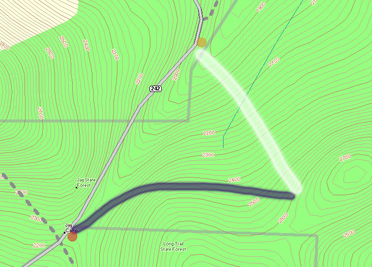
A topographic map of the Gilpin Mountain area showing Route 242 (gray) and the approximate ascent (thick blue line) and descent (thick white line) routes used during today’s ski tour
At the crest of Route 242 (elevation ~2,250′), The Long Trail crosses the road, and along with the trailhead there’s a parking area (see the red dot at the lower left corner of the topographic map provided with this report), so this appeared to be a good place to start a hike. My initial plan was to head south along The Long Trail (note on the map where the gray-dashed Long Trail heads south from the red dot) toward Domeys Dome (elevation 2,913’ – not visible on map) and ski down from there to Route 242 where we would have a second car waiting (elevation ~1,500′ – off the map to the south). This would provide a roughly 1,400′ vertical run, with a calculated pitch of around 23 degrees.
When we actually arrived to surveil the area though, we discovered that what looked good on paper didn’t look as enticing in real life. The parking at the bottom was quite far away, and the slope leveled out too quickly to a very low angle. In 10 degree temperatures and brisk winds, we gathered together in one of our cars at the top of Route 242 and consulted the maps for new guidance.
We decided to drive the car along Route 242 to the northeast (in the direction of the Jay Peak base area) as the road descended toward the resort, while we looked for potential ski lines. There were plenty of lines off to our right, as well as a second parking area for cars (yellow dot on the map) at the next low point of Route 242 (elevation ~1,950′). This setup seemed almost too perfect. I say “almost”, because unfortunately The Long Trail doesn’t go in that direction at all, and we assumed we’d have to blaze our own path through deep powder to get to where we wanted to go. We had seen what appeared to be a trail heading off in the direction we wanted, very wide (10 feet or so on average), but we were still unsure if it would work for us. As we got closer, we could see that someone already had a skin track heading that way; we’d found our hiking route.
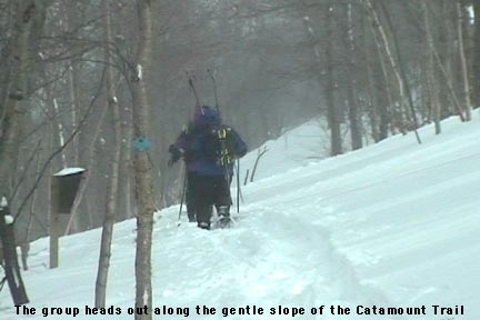
From the top of Route 242, we got our gear together, threw on our snowshoes, and headed out along the trail (our ascent route is roughly marked by the thick blue line on the map). The image of the group heading out shows the general look of the terrain at the start of the trail. I soon noticed from the blazes that this was The Catamount Trail (the HUGE cross-country ski trail that travels the whole length of the state). The upward slope of the trail was very slight, but as we continued on our ascent, Route 242 quickly fell away to our left and we could watch the vertical drop for our potential ski run grow rapidly. At an elevation of around 2,400′, we broke uphill of The Catamount Trail (following the switchbacks of another skin track) to gain some additional vertical. It turned out that other folks had been in the area today, as shown by the skin tracks, ski tracks, and the people themselves. We continued to hike up to around the 2,600′ mark, and then as the slope started to mellow out, we decided to boot up and test out the terrain. A group of about five Telemark skiers passed by on their way up, one of them deciding to cash in at that point and start his descent as well.
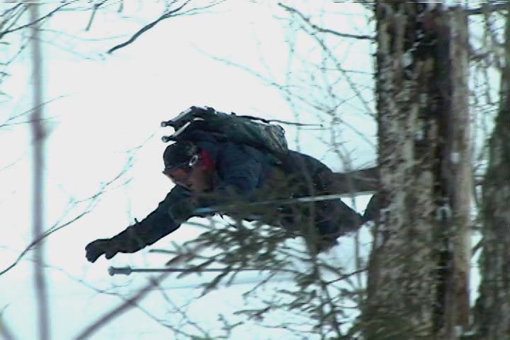
Dave slices his way through some branches as he encounters a brushy area on one of our ski runs.
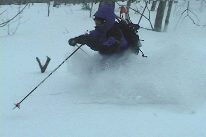
It’s amazing to think that last weekend had been a situation of rain, warm temperatures, and a refreeze that turned the entire snowpack into a solid, crusty mess. From where we were standing, it was basically bottomless powder, a situation in which removal of snowshoes or skis meant trouble standing. The pitch of our descent started off mellow, with various areas of hardwood glades and some underbrush at times. The snow was nice and light; I’d estimate its density at somewhere in the 5-7% H2O range. The slope gradually got steeper as we picked lines along the way that looked good and headed in the general direction of our lower shuttle vehicle. Our general descent route is marked by the thick white line on the map. Even with the deep snow, some areas had enough underbrush that they made picking lines difficult. Some areas we quite clear, but a bit of scouting was needed to find them. James picked direction with his usual finesse, and guided us right down to the parking area and our waiting vehicle (Dave’s pickup truck).
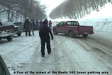
A scene from the lower parking area on Route 242 where many people finished off their ski runs, with skiers of all types constantly coming and going
Our total vertical skied was approximately 700 feet, which was a nice run for only about 400 vertical feet of very easy hiking. At the parking area it felt like the local version of Grand Central Station for backcountry skiing. There were numerous cars, lots of people hanging out, and skiers pouring down off of both sides of the road enjoying the powder. James said it felt like a local backcountry Mecca (in reference to the number of people). Although a few of the people were from our side of the road, most came down from the Jay Peak side, riding the lifts and then catching a beautiful long run all the way down to Route 242. Some people had cars waiting for them, some hitched rides, and some looked like they had no idea where they were. It was an awesome scene to see though, with all those folks out there enjoying the snow. I’m thankful we weren’t skiing the other side of the road though (the Jay Peak side), as the number of skiers on those slopes had even that vast amount of terrain tracked up quite well. I had always thought of heading that way when skiing Jay Peak, and had no idea how many people did it. There was a continuous flux of people coming through that area all day long, with cars pulling in, parking, leaving, people looking for rides, giving rides, looking for people that they had lost, etc. etc. etc.
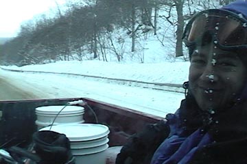
Catching a ride back up to the top of the pass in the back of Dave’s pickup truck
Using our vehicles, we shuttled our crew up to the top of the pass, and started for another run from the upper parking area. Unlike the lower parking area, there were only a few cars there, and no people. The wind was blowing and the temperature had stayed around 10 degrees the whole day, but the sun had come out for a while during our first trek, and it had made that a great hike. We had a snack in the car, and headed off along The Catamount Trail for round two. Our first run had tuned us into the lay of the land its terrain nuances even better, and now James had plans for some even sweeter lines. We hiked the same general route (much easier at this point with the presences of our tracks and those of numerous others who had been up). We cut upward off The Catamount Trail a bit earlier, and topped off near the same elevation as before. This time we found some lines that were even more open, although we did still had to pass through some brushy sections.
James helping out with some footage for our crash reel!
I’m not sure how good the ski touring in this area would be with low snowpack, since even with four feet of base, there was still brush in some areas, but it was certainly good skiing with our usual midwinter base depths. Some of the most fun we had was due to spectacular falls, with all four of us getting in on the act by diving into the powder. We shot about 30 minutes of video, hopefully enough to have a segment in this year’s ski movie. We’ll have to see, but either way, we got some of our best falls for this season’s crash reel! 🙂
Jay skiing some deep New Year's Eve powder on Middle Earth at Castlerock
Sometime around Monday or Tuesday of last week, I began hearing about a proposed nor’easter for the New Year’s weekend. The weather gurus on the ne.weather newsgroup were going nuts, as this could be the first big storm for the coastal cities in a number of years. A clipper type low along the northern tier of the U.S. might merge with a storm coming out of the south, and Boom!, bomb out as a nor’easter off the coast. Although the southern storm pretty much went off the coast down south, the situation was set so that the northern low transferred its energy and made a low off the coast anyway. Two friends, Dave and Chris, came up from southern New England, and as Saturday progressed, we watched the storm dump plentiful snows across New Jersey, Philly, New York City and many points down south of us. Some areas of New Jersey were in the bull’s eye with over two feet of snow. The latest report I saw for Mountain Creek ski area in NJ was 29 inches. The Catskills also got some heavy bands of snow, I saw Hunter Mountain reporting 30 inches. Overnight Saturday, the storm worked its way up into northern New England, and by early Sunday morning, Sugarbush was reporting 10 inches. This number would swell to 16 inches by the end of the day, and 24 inches by Monday. Click through to see the full Sugarbush report with images.
My route on Mt. Mansfield today took me up toward the Sunrise trail to enjoy some early October powder.
Today I went up to Mt. Mansfield to get some turns in the snow before it started to disappear. A nice cold snap has dropped over a foot of new snow on some of the mountains, with snowfall reaching even down to Burlington. Traveling on I-89, I first saw snow on the Robbins Mountain Power Line, up around 2,000′. It was very patchy and hardly noticeable, so I was worried about how the lower elevations would be on Mt. Mansfield. Things looked up as I entered Waterbury (~520′) and found traces of snow on the ground. At the base of Mt. Mansfield (~1,600′) there was an inch or two of snow on the grassy surfaces. I hiked up in the region of the triple, looking for slopes that had nicely mowed grass for the trip down – a map of my route is pictured along with this text. At around 2,500′, the snow was over 6 inches deep so I threw on my snowshoes to make the going easier. I stopped my hike at around 2,920′ (see map) since it was time to head to work, but the snow depth had increased to about 8-10 inches. The snow was fairly heavy (~11% H2O or so), but light enough to make powder turns. I’m sure it was even better up at 4,000′ and above. The first half of the run had the best snow, with much stickier stuff lower down, but I was still able to ski right back to the base of the triple and make a quick departure for Burlington.
With the unknown element of mixed precipitation, we decided to head for Jay Peak on Saturday. Along with Bennett, we even pulled Mr. Mango Madness out for his first day of the season. In anticipation of bad roads, we loaded ourselves into Bennett’s big rig and headed north. Burlington had accumulated about 4 inches at this point, and although it was temporarily coming down only lightly, it picked up as we headed toward Jay Peak.
We were proud of ourselves for arriving on time (not easy), and took a run on the double before the tram opened. We headed down Green Mountain Boys (I think) and found about 4-6″ blown around by the wind; best on the sides. The powder was not super light, but not bad (and it was still snowing’ like crazy). By the time we got down, the tram was ready and we hopped aboard. We headed out on Vermonter, finding about 12″ of chowder, a tough ski, especially with the humidity and our goggles going crazy from the moist tram ride. I think I heard the term “skiing by Braille”, or some such out of somebody in the group. On a personal note, of course my goggles fogged up right in the middle, but if I turned my head sideways, I could look out the edge and see, really messed with the balance, but oh what fun.
After another run on the tram, we headed over to the triple, and headed for Timbuktu (one of our favorites). We hung to the right to catch fresh snow, but found plenty of ice storm damage in that area, and with the snow that had fallen so far, only very short lines were available, and even then it wasn’t a secure feeling with the fallen trees around. As we headed back left, we found that clearing had been much better, but this area was already getting pretty tracked.
We boarded the quad and found our best run of the day by far. North Glade must have just recently been opened because there were few tracks, and 8+ inches of powder; we left there wanting more (and trying to figure out where we were and how we got there.) We finished off the day with a couple of tram rides (amazingly, you could always get right on the tram with no line) and hit some areas that may not have been officially open, but didn’t exactly have ropes either. Oh well, there were three of us, and sometimes ignorance is bliss; in the form of untracked snow.
One of the highlight’s of the day was Mango simply exploding on a very flat section of Deer Run. It looked like a snow snake just jumped out and bit him; and the look of “what the…!” as he went down into a crumbled heap of man and equipment, was priceless. During one of our traverses that I was leading, I got ridiculed for my choice of line, something about “What rabbit made this!” as Bennett found himself stuck between a tree and a hard place.
During one of our tram rides, the ticket checker said that it was raining just about everywhere south of Jay. I was initially skeptical, then happy that we were at Jay Peak of course, then worried about what would happen at places like Sugarbush. Stay tuned for our Sunday installment in which the truth will be revealed!


