Bolton Notch, VT 01FEB2015

An image of Jay hiking with skis his pack on Bolton Notch Road in Vermont to return to his car
An image of ski tracks in backcountry powder in the Bolton Notch are of Vermont
The western slopes of the Northern Greens are chock full of powder right now.

Relative to yesterday, today’s forecast called for temperatures to be a couple of degrees warmer, but the reality was that the cold arctic air would still be in place, and temperatures would likely be in the single digits F in the mountains. Add some breezes, and the wind chills would be well below zero, so it was an easy call for E and Claire to once again cancel our BJAMS ski program at Stowe. E and the boys were happy to stay inside out of the cold, but I figured I’d take the opportunity to get out for a workout and make some turns. It’s still weather that’s better suited for self-powered ascents vs. riding lifts as far as I’m concerned, so I made plans for another backcountry ski tour.

“…it was easier than breaking trail through the powder, which was already in the 12-15″ range.”

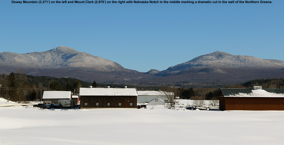
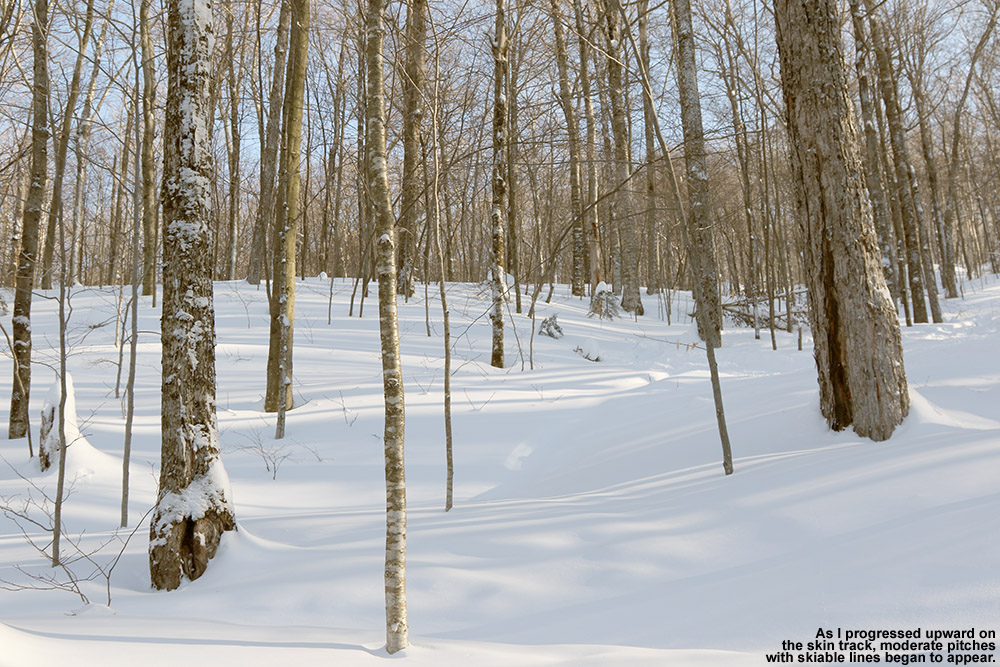
I figured I’d go with a fairly quick tour today, something a bit closer to home and with modest vertical. I was impressed with the snow I found yesterday on my Dewey Mountain ski tour, so I figured I could stick with some west side skiing, and the Bolton Notch area came to mind. I know there’s plenty of skiing on the eastern slopes of Bolton Notch, as I’ve heard about if from friends and colleagues that live there. Many people who live on the east side of Bolton Notch Road simply hike up from their back yards and ski back down. The ridgeline up above stretches from the Oxbow Ridge area and Bolton Notch Peak in the north, to Stimson Mountain in the south, and just as it marks the eastern wall of Bolton Notch, it represents the western wall of the Bolton Valley area. I’ve skied down from the ridge on the Bolton Valley side, and when I’ve been up there on the ridge, I’ve even heard people just down below me on the Bolton Notch side. I suspected the people I heard were backcountry skiers, and figured that at some point I’d pick a day to check out that side of the ridge.

An image of the sign at the parking area for the Preston Pond Trails in Bolton Vermont
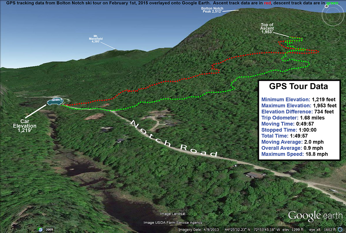
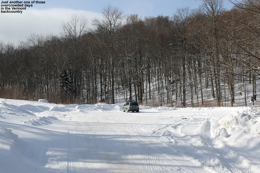
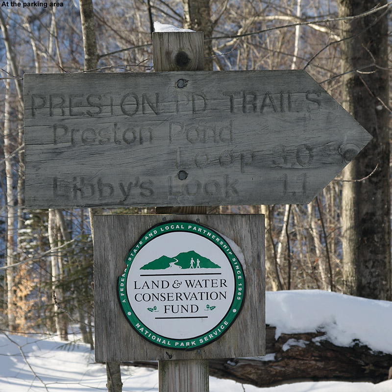
Although my preference was to explore the skiing options down below the ridge at the point where I’d heard people in the past, for my first exploration of the notch I planned to start a tour from wherever I found convenient parking. That turned out to be a couple miles north of where I was initially thinking, at the parking area for the Preston Pond Trails. The lot is at an elevation of ~1,200′ on the west side of the road, and although it’s fairly small and already had another car in it, there was plenty of room for another. So I’d found decent parking, but in reality, I wasn’t all that optimistic about the potential for skiing in that area. The terrain directly to my east featured the huge cliffs of Bolton Notch Peak looming over everything, and they were cliffs that were essentially sheer and unskiable. And as if that wasn’t enough, the terrain below the cliffs was fairly steep and littered with car to house size boulders, presumably large chunks of rock that had fallen from the cliffs above. The prospects for skiing looked much better about a quarter mile to the south, where the terrain was a bit mellower and not so full of boulders. For my first visit to the area though, my plan was to just look for a skin track and see where it led me.

“The depth of the surface powder snow was actually getting pretty close to yesterday’s depths at times, up into the range of 18″ or more, but these elevations just didn’t have as substantial a base.”

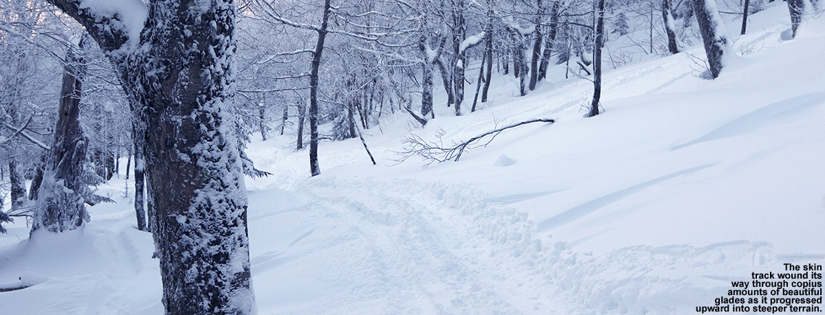
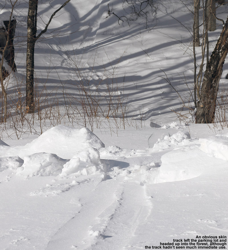
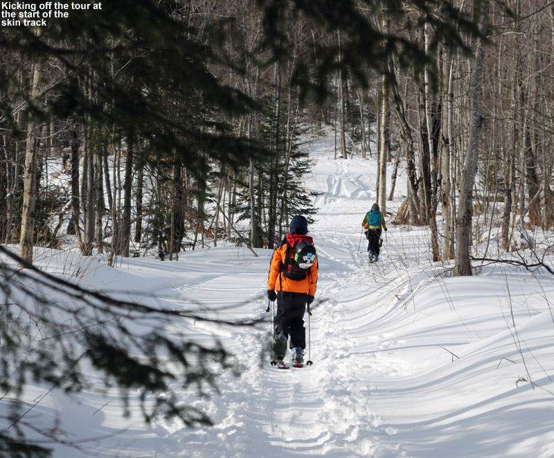
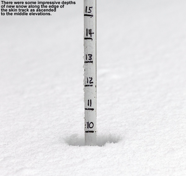
As has been the case as of late, temperatures were in the single digits, so I quickly geared up and set out. Right across the road, I saw ski tracks heading up into the trees, so I figured that must be the standard skin track for the parking area and hopped on. Well, it didn’t turn out to be a well-established skin track, it was just a skin track made by one or two previous skiers, and it left a lot to be desired. I’m not sure what they person who made it was thinking, but they set it with some steep pitches and cruxes that required scrambling or holding onto trees to get up and through. It seemed to be heading up toward the unskiable terrain of the cliffs, and since it was rather poorly placed, I thought more than once about simply breaking off on my own to the south and contouring up in elevation more slowly. But, I stuck with the skin track because even though it was poorly done, it was easier than breaking trail through the powder, which was already in the 12-15″ range.

“The ski terrain wasn’t looking more promising in any direction – to the north it was cliffs and boulders, and to the south it was getting too flat.”

Finally, at around 1,700′, the skin track intersected with the VAST trail that runs through the notch area, and the prospects for getting to some decent skiing were looking a little better. The person who’d made the track appeared to have headed off to the south on the VAST trail, and this was good because this was the direction toward what looked like much better ski terrain. I headed up a rise on the VAST trail, and kept my eyes peeled for signs of the skin track heading back into the trees. Indeed after a few hundred feet, I saw the skin track head off to the left on what looked like an old logging road. The ski touring potential there were looking good, but after about five to ten minutes of additional skinning, it was becoming obvious that the skin track wasn’t really heading toward any primo ski terrain. It followed the logging roads in the area and was generally quite nice in terms of pitch, but it soon looked like whoever had made the track had descended right back down it. I gave it a few more minutes until I saw that the track’s creator clearly didn’t know where they were going. There were small side loops in the track and signs of doubling back where the person seemed to be surveilling the area. After some of these small loops, I could see that the person did eventually continue onward, but at an elevation of a bit below 2,000′ I decided to call it. The ski terrain wasn’t looking more promising in any direction – to the north it was cliffs and boulders, and to the south it was getting too flat. I’d already seen some options for turns near where I was, which actually might be the local sweet spot for ski potential in that immediate area.

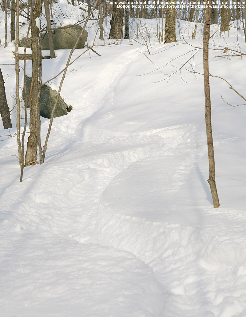
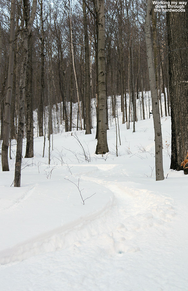
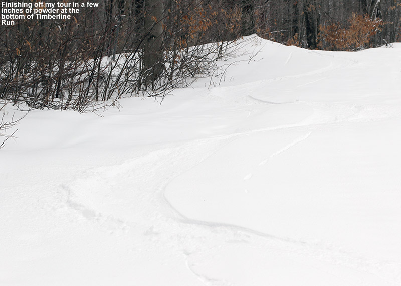
“There were some nice open hardwoods in there, and I got some great powder turns.”

I had some soup, switched over for the descent, and began my way back down in the area of the skin track. I was able to veer off the track and get into some nice terrain for powder turns that would eventually return me safely to the track. It was my first chance to actually check out how the snow was skiing, and I was a little leery because the snow down at these elevations wasn’t as deep as what I’d been in yesterday up on Dewey Mountain. The depth of the surface powder snow was actually getting pretty close to yesterday’s depths at times, up into the range of 18″ or more, but these elevations just didn’t have as substantial a base. When I actually got turning though, I found that the overall combination of powder and base was more than sufficient, especially floating on 115 mm fat skis. And I have to say that the fluff there in the notch was of really high quality – definitely up to the standards of Champlain Powder™.

An image of a "Posted - Private Property" sign in the Bolton Notch area of Vermont
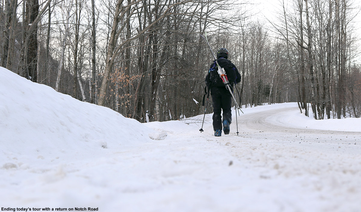
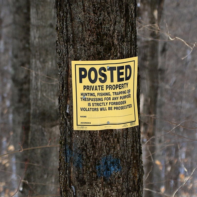
When I got back down to the VAST trail I decided that for the rest of the descent, I wasn’t going to go near the boulder-infested area in which I’d skinned up if I could help it. I opted to drop right from the VAST trail to Notch Road, or at least as straight down as the terrain and private property boundaries would let me. There were some nice open hardwoods in there, and I got some great powder turns. I had to navigate some ledges, but a shuffle to the left or right would usually get me to a mellower line around them. Unfortunately my direct descent was stopped when I ran into a “POSTED – PRIVATE PROPERTY” sign that belonged to one of the property owners below. I had to traverse above it, so I chose to go northward in the direction of the parking area. After a few minutes of traversing and skiing some lines, I saw that I’d soon be getting onto the property of a couple of additional houses, and fortunately, I found a nice area in between that seemed to be out of sight and off anyone’s property. That shot brought me right down to the road, where I strapped my skis on my pack and made the short walk back to my car.

A Google Earth map showing GPS tracking data from a backcountry ski tour in the Bolton Notch area of Vermont
The GPS tracking data from today’s backcountry ski tour in the Bolton Notch area

While I was packing up at the car, the owner of the other vehicle arrived with her dog. She actually lives right on the road, and we began to talk skiing. She asked how it was, and I said that the snow was great, but the ski terrain, as I’d expected, was somewhat limited. Between the cliffs up above, areas of terrain that were too flat, areas of terrain that were of inconsistent slope and alternated between ledges and run outs, and the private property boundaries, it just wasn’t a prime backcountry ski spot. There were some very nice lines with open trees, but overall it wasn’t a lot of bang for your buck. I inquired about other parking areas on the road, and she couldn’t think of any immediately, but suggested to go to the Long Trail area. She said that once you got up above the VAST trail in that area, there were some nice lines. That is indeed back where I’d initially thought I’d find some good terrain, so I’ll likely try to find my way over there at some point in the future.

Dewey Mountain, VT 31JAN2015

An image showing Nebraska Notch surround by Dewey Mountain and Mount Clark as view from the west in the Underhill area of Vermont
An image showing some ski glades on Dewey Mountain in Northern Vermont
The glades on Dewey Mountain held some fantastic Champlain Powder today.

I’m sure there are many interesting stories that begin in a dark room, but in this case, the story begins in a darkroom. It was early June of 2010, and I was in the Pharmacology darkroom on the third floor of UVM’s Given Building. It must have been a popular day for western blotting, because I was in there with another guy as we both queued up some films for the developer. I can’t recall his name, but I think he knew I was a skier, and as he was as well, the conversation almost inevitably migrated in that direction. As backcountry skiing was discussed, he told me that I should check out the west face of Dewey Mountain sometime – he said you just drive up to the top of the road, put on your skins, and go up. It all sounded pretty straightforward from what I could tell. Being well entrenched in the warm season at that point, there was of course no way I was going to run off and check it out anytime soon, but I made a mental note and figured I’d check it out at some point in the future when the time was right. As one might expect, things happened to align, and that time was today.

“I was thankful to be able to use the track, because that powder was indeed deep – my checks were giving me measurements of 20-24″ of fluff.”

Our most recent snowfall in the Northern Greens came yesterday from Winter Storm Kari; it wasn’t an especially big storm up here, but much of the Champlain Valley picked up a half a foot of snow, and the west side resorts like Bolton Valley and Smuggler’s Notch received more than a foot. While yesterday’s temperatures were quite pleasant (and the skiing fantastic from what I hear), the storm pulled down more arctic air and was back into highs in the single digits F for the weekend. Combined with wind, temperatures would be well down into the negative numbers, and E and the boys had no interest in going out in that. I didn’t really feel like riding the lifts in those temperatures either, so another backcountry day was calling. I’d been a bit leery to head to the western slopes with the way they were lagging in snowpack earlier in the season, but with the way they cleaned up in this most recent storm, it seemed like the time had come. I had enough time to head out toward Underhill, so I figured I’d finally head to the top of the road and see what Dewey Mountain had to offer for snow and terrain.

“The best way to describe what’s up there is simply “steep and deep” terrain.”

It turns out that “the road” that you head to the top of, is Stevensville Road coming out of Underhill Center. There’s a fairly large parking area there, and I’d actually just visited it this past fall when Mark and I did a shuttle hike up to the ridge line of Mt. Mansfield and down to Underhill State Park. I’d never been there in the winter though, and it was an interesting drive. Even though this past storm wasn’t a big one, as I got into the upper elevations of Stevensville Road, I could see that they had a ton of snow, and it looked like a mini fluff bomb had gone off in the area. Delicate upslope Champlain Powder™ snow was piled on everything. The prospects for some powder skiing were looking very good.

An image of the Overland Cross-Country Ski Trail sign near the Stevensville parking lot outside Underhill Center in the Green Mountains of VermontThere were about a half dozen cars in the parking area as I geared up and hopped onto the skin track at the east end. It was really more than a skin track; there had been enough use that the trail was essentially packed. It reminded me of a narrower version of the Bryant Trail at Bolton Valley. It wasn’t long before I came to a junction that gave me the option to follow either the Overland X-C Ski Trail or the Nebraska Notch Trail. My initial assessment of the area on Google Earth had me planning on the Overland side, and with the vast preponderance of skin traffic heading in that direction, it sealed the deal. I did a few checks on the depth of the surface snow as I continued onward, and was getting measurements in the 15-16″ range. Even down in that 1,400′ to 1,500′ elevation range, the area had clearly been reeling in some good snows as of late.

An image showing some potential ski terrain above the Overland Cross-Country Ski Trail on the west face of Dewey Mountain in Vermont
Catching views of skiable lines along the skin track accessed by the Overland Trail

After about a half mile, the blazed Overland Trail seemed to head off to the north across the local streambed, but I stayed on straight ahead following the majority of the skin traffic. The skin track meandered upward through hardwoods, and I could see that people descending in the area would sometimes head off to the sides of the trail and ski the surrounding powdery terrain. The skin track began to steepen, and at some point above the 2,000′ mark I began to get into more obvious glades. Based on the distribution of mature trees vs. hobblebush and striped maple saplings, it looked like the area had seen some pruning at some point in the past. The skin track steepened further, and very obvious ski lines through glades with mature trees became more apparent. I caught sight of a couple of women who were ascending the skin track ahead of me, and eventually caught up to them at an elevation of around 2,700′ as they were switching over for a descent. We were just hitting the evergreen line, and I could see why they would start a descent there, but as I could also see a good number of ski tracks coming down from the evergreens above, I decided to push on a bit farther. We exchanged greetings as I prepared to step up above the skin track to get around them, but they happily moved when they saw just how hard it was to step into the powder and go around the track. I was thankful to be able to use the track, because that powder was indeed deep – my checks were giving me measurements of 20-24″ of fluff. I continued on up into the evergreens for about another hundred vertical feet, following a mish mash of skin tracks and possibly descent tracks, until I found a nice spot to stop that looked like it would give me a good start to a run.

An image showing a skin track for backcountry skiing access among glades on the west face of Dewey Mountain in Vermont
Beautiful glades along one of the skin tracks on the west face of Dewey Mountain

I actually had a nice sheltered spot among some evergreens; it would have kept me well out of the wind, but I really hadn’t experienced any during the trip anyway. I poured some soup from my thermos to let it cool in the snow, and began the gear switch for the descent. It was definitely one of those “one skin at a time” types of transitions, as the powder was so light, fluffy, and deep, that it would be a hassle getting out of my skis entirely. I’m sure the temperature was somewhere below zero up there, and I made the switch to my heavier gear quickly before I began to cool down post-ascent. I had my soup, gathered my gear, and got set to push through the evergreens to look for a line.

“…it’s not the sort of terrain that would be great without sufficient snow – you’d be bottoming out all over the place.”

A little traversing through the evergreens was all it took, and I was into skiable terrain. The best way to describe what’s up there is simply “steep and deep” terrain. It’s indeed steep, probably 25 degrees or so, and you really want the deep because it’s not the sort of terrain that would be great without sufficient snow – you’d be bottoming out all over the place. Fortunately, that’s not the case with the current snowpack. The roughly two feet of powder up there provided plenty of cushion, as well as resistance. There’s plenty of spacing in the hardwoods, and you can open up the turns; even slower Telemark turns were comfortable thanks to the tree spacing and depth of the surface snow. Well, some credit in that department is definitely due to fat, rockered skis as well. Also, any concerns about west side base depths was pretty much erased on this outing – if there were no concerns on that really steep terrain, it’s not an issue. The steep terrain goes on for several hundred vertical feet before it starts to become more moderate. I hung to the left and continued downward, eventually finding a popular catch track that actually headed up a short incline and off to the skier’s left away from the area of the skin track. I suspected that this would work in some additional lines down to the skin track, but available daylight and air temperature suggested that it would be best to save that exploration for another time. I headed down through the various trees around the area of the skin track, and there were plenty of additional turns to be made. Eventually as the pitch of the terrain became shallower, the Overland Trail itself was the most practical route, with just occasional forays off into the powder as speed allowed.

A Google Earth map showing GPS tracking data from a backcountry ski tour on Dewey Mountain in Vermont
A Google Earth map showing GPS tracking data from today’s backcountry ski tour on Dewey Mountain

One nice aspect about the current snow conditions up there is that they allowed for good skiing in both the steep terrain, as well as the more moderate terrain below – the depth of the powder decreased pretty well in concert with the terrain’s pitch. One could easily ski just some of the lower sections of terrain if the depth of powder didn’t suit the steep shots. In any event, thanks to the quality and depth of the snow, it was some pretty fantastic skiing for an exploration that started in a darkroom. I guess there might have been some nice symmetry to the report if I finished my run as darkness approached, but with these temperatures it’s not wise to push your luck being out there too late.

Nebraska Valley, VT 25JAN2015

An image showing a car parked in the overnight lot for recreational use in the Nebraska Valley near the Lake Mansfield Trout Club
An image of ski tracks in powder snow on a backcountry ski outing in the Nebraska Valley area of Vermont
Gliding through some backcountry powder in the Nebraska Valley area today

The weather yesterday was very comfortable, with highs in the local mountains around 30 F at ski resort base elevations. Today was a different story though; mountain temperatures were expected to start in the single digits and drop in the afternoon to produce wind chills well below zero. With that forecast looming, E and Claire decided to cancel today’s BJAMS ski program at Stowe to avoid any frostbite issues with the students. The program can make up the session later in the spring anyway, hopefully on a nice warm day.

“The ski lines were obvious and everywhere, there’s no hunting around necessary if you’re looking for some moderate angle powder to ski.”

With the chilly forecast and some extra time in the afternoon, I decided to head out for a backcountry ski tour in the Nebraska Notch area. Some of the higher elevations of the Northern Greens did pick up as much as 4 to 6 inches of snow overnight, so that added a little extra incentive to get out and see how conditions were faring. I’ve wanted to do an exploratory tour near Nebraska Notch for a while, and I’m familiar with the tour highlighted in David Goodman’s book that starts on the west side of the notch. I’d been through some of that area this past summer when our family was on a backpacking trip with the Handler’s, so I thought that something on the east side would be a fun alternative. From Jacquie, I’d heard about the backcountry skiing potential above the overnight parking area near the Lake Mansfield Trout Club, so I decided I’d give that a shot. It’s a quick trip from our house in Waterbury, and I’d be able to take care of some necessary grocery shopping on the way home as well.

“I’m not sure how deep the base was, but surface powder was 13-14″ in the trees just above the parking area (~1,100′), and pushing two feet up high depending on prior wind and sun exposure in underlying layers.”

Heading up Nebraska Valley Road, I noticed that as I approached the 1,000′ elevation mark, the snowpack really took a jump. It went from the 8-12″ that we’ve currently got in many of the lower mountain valleys of the Northern Greens to something more, and you could really see how the higher elevations of the Nebraska Valley were holding the snow. I pulled into the lot for overnight recreational parking, and it was empty. There was probably space for 20 cars, but mine was it. I guess it’s just another one of those harbingers of the overuse and overcrowding associated with skiing in the Vermont backcountry. In any event, I could see an obvious, although apparently lightly used skin track off to the right heading up into the forest. More importantly, I could see the associated ski terrain looming right above me; well-spaced hardwoods appeared to fill the entire slope, and you could immediately see that there was some great skiing right down to the parking area.

An image showing a skin track heading off into the forest for backcountry skiing in the Nebraska Valley area of Vermont
An old skin track from the parking area marked an obvious route of ascent.

An image showing an old chain on a hook hanging from a tree along a backcountry skin track in the Nebraska Valley area of VermontThe skin track ascended through the hardwoods on what appeared to be an old logging road, and it sliced right through an impressive chunk of ski terrain. The ski lines were obvious and everywhere, there’s no hunting around necessary if you’re looking for some moderate-angle powder to ski. After looking at the area on Google Earth this morning, I’d decided to explore a drainage off to the northwest of the parking area, and conveniently that’s just where the logging road and skin track headed. After a few hundred feet of ascent I could see that there were a number of ski options, but three main ones were very evident: You could ski the logging road itself, which was relatively narrow and contained the skin track, but would serve up some decent turns. Much more expansive options were to either contour off to the east and make turns in the vast face of terrain containing the hardwoods, or head westward and ski steep gullies down into the drainage. I had plenty of time to survey the topography and decide on descent routes as I continued up the skin track; it’s set at a very nice, consistent pitch with none of these steep spots that might promote slipping.

An image of a "Tubbs Snowshoe Trail" blaze on a trail along the Sky Top Ridge on the north wall of the Nebraska Valley in the Green Mountains of VermontAt around 2,100′, evergreens began to mix in with the hardwoods, and the logging road gradually gave way to a skin track that worked its way more tightly through the forest and ascended small streambeds. By 2,500′ I was into exclusively evergreens, and the available snow was getting deeper. I’m not sure how deep the base was, but surface powder was 13-14″ in the trees just above the parking area (~1,100′), and pushing two feet up high depending on prior wind and sun exposure in underlying layers. I hit the ridge line (Sky Top Ridge east of Dewey Mountain) at an elevation of roughly 2,800′, and headed off to the east on the ridge line trail. Appropriately, the trail on the ridge is known as the Skytop Trail, and David Goodman’s Backcountry Skiing Adventures: Vermont & New York book has a specific chapter on touring there. I found it marked with red blazes, but I also noticed a “Tubbs Snowshoe Trail” sign as well. I continued on the Skytop Trail for another few minutes until I hit a local high point where I decided to halt my ascent.

“Some exploring would have been fun, but with the time of day, cold temperatures, and being solo, there really wasn’t much margin for messing around.”

Up there on the ridge it was cold, noticeably colder than the 10 F at the parking area. I was out of the wind, but it wasn’t a temperature to hang around in. I poured some soup and let it cool a bit while I changed over for the descent. My plan was to head back down in the area of the skin track for that first chunk of the descent, since I hadn’t come across any obvious lines in other areas. Some exploring would have been fun, but with the time of day, cold temperatures, and being solo, there really wasn’t much margin for messing around. During the ascent I’d seen that there were plenty of steep, ledgy areas above the open hardwoods. Those ledges and some dense evergreens lay right below me, and from what I’d seen it would be very easy to get cliffed out up there. Any exploration of that terrain will have to wait for another time.

“Being south-facing, it’s not the kind of terrain that one would want to ski on sunny days when temperatures are getting marginal, but on a midwinter day like today, the snow was great.”

The descent up high along the general area of the skin track was very nice – the powder was deep and there were occasional options of ski lines that cut corners or veered away temporarily from the track. When I was back into the open areas of hardwoods, I cut left of the track following a previous skier’s lead, and traversed out into the face of terrain that sat well above the parking area. It was classic Vermont hardwood ski terrain; there weren’t any obvious maintained lines, but you didn’t need them. It was pretty much see it and ski it. The powder was a little shallower on some pitches, no doubt a function of that fact that the terrain faces south and can get plenty of sun due to the leafless deciduous trees. Being south-facing, it’s not the kind of terrain that one would want to ski on sunny days when temperatures are getting marginal, but on a midwinter day like today, the snow was great. I eventually ran into the skin track again, and cut to the other side as I saw some attractive ski lines heading in that direction. I finally had to do a short traverse to get back to the last pitch above the parking area, but with the open nature of the forest, navigation was pretty easy.

An image showing GPS data on Google Earth for a backcountry ski tour in the Nebraska Valley area of Vermont
The GPS tracking data of today’s backcountry ski tour in the Nebraska Valley of Vermont plotted on Google Earth

I’d say today was a great first visit to the area; those hardwoods are exceedingly skiable, with the main downside being that it’s south-facing, so the quality of the snow needs to be watched with respect to recent weather trends. The snowpack isn’t even especially deep right now, and I only encountered the occasional underlying obstacle to contend with. As usual, if you throw another couple feet of base down, more and more lines will simply open up and get even cleaner as additional saplings and other trees get buried. On that note, there’s another winter storm (Juno) coming into the area over the next couple of days – it sounds like the bull’s-eye areas are down to the south, but it’s expected to give us a moderate shot of synoptic snow up here as well, which should further improve base depths.

Bolton Valley Nordic and Backcountry, VT 18JAN2015

An image of Erica passing a sign indicating the Gotham City area of the Backcountry Ski Network at Bolton Valley Ski Resort in Vermont
A picture of Jay skiing the Sasquash glade on the backcountry network at Bolton Valley Ski Resort in Vermont
Trying to get to some of that Bolton Valley backcountry powder today before temperatures warmed up too much.

The boys both ended up staying over at the Handler’s house last night, and we wouldn’t be picking them up until the Warren Miller ski movie (No Turning Back) in Stowe this evening, so that gave E and I a chance to get out for a bit of skiing together today. I got a really good sampling of the snow and glade conditions on my solo ski tour on the Bolton Valley Nordic and Backcountry Network yesterday, and I found some spots that I thought E would really like, so I planned on a mini tour that would let us focus on just those glades. The Gotham City area and the glades below that looked like a very good option; based on the pitch, tree spacing, and depth and consistency of the powder, it felt like a good fit for E’s off piste Telemark skills.

Temperatures were rising today ahead of our next incoming winter storm, and they were right around the freezing mark when we arrived up in the Bolton Valley Village at midday. The resort was absolutely packed with the cars of visitors; now that the temperatures were nice and comfortable, presumably everyone was making their holiday trips to the slopes. The Village lots were actually all full and they were parking people down at Timberline, but since we’d be visiting the Nordic side of the resort, we figured we’d be able to find something down by the Nordic Center. Even down there it took some creative parking to get a spot, but we managed one in the lowest tier of the main area.

We walked over to the tennis court area, strapped on our skis and began following a short skin track that others had made that quickly merged onto Broadway. From there it was up to the Bryant trail, where we stopped at the highest junction with World Cup to drop some layers and open some vents. We continued on Bryant up to the 2,400′ elevation, where we cut off over toward Coyote. There’s a skin track leading right up into Gotham City that I’d seen yesterday, and my estimates were that an elevation of ~2,400′ was just about right for getting there. Indeed we quickly found the skin track off Coyote, and it was just another few minutes up to Gotham City. They even have a sign now that welcomes you to the area. I’m not sure when it was, but at some point today I realized that Gotham City must of course be name after Ann Gotham of Friends of Bolton Valley Nordic & Backcountry. I’d initially thought that the name referred somehow to the Gotham City of Batman fame, but the link to Ann seems so obvious now.

A map of the Nordic and backcountry terrain network at Bolton Valley Ski Resort in Vermont
A map of Bolton Valley’s Nordic and Backcountry Network with more than two dozen glades listed.

We stopped our ascent in the middle of Gotham City to switch over for descending, and we were treated to sunshine peeking in and out from behind clouds as we enjoyed the mild air and snowy scene. We had some soup and hot chocolate, but they almost seemed out of place with the relatively mild weather. Despite the rising temperatures, the powder had appeared to hold up pretty well in areas we’d checked during our ascent, but we soon noticed that it was starting to stick to our skis in sunny areas. We knew we’d better get a move on lest the powder turn to mush on us.

We headed down by skiing a combination of Girls and Sasquash, and fortunately the powder was still decent in the more shaded areas. It was starting to turn in sunnier areas though, and when we got into some of the lower elevation glades below World Cup, it was definitely past its prime. Fortunately we’ve got a winter storm on the way this evening, with Winter Storm Warnings up for the Northern Greens. A good storm will make quick work of any adulterations to the powder in those lower elevations.

In any event, we got some good turns, hit four different glades in that short tour, and finished off on the Telemark Practice Slope. I bet one could easily do that tour in under an hour if they got right to it and didn’t pause to do other things. An efficient route for access might be just to go up Coyote, although I’m not sure if the skinning there would be quite as easy as on Bryant since it’s not used as much. We’ll definitely get back there with E, and hopefully the boys with even better snow, but it’s a great little tour that hits some beautiful ski terrain.

A map of a ski tour on the Bolton Valley Nordic and Backcountry ski network in Vermont
The GPS tracking data from today’s backcountry ski tour on the Bolton Valley Nordic and Backcountry Network plotted on Google Earth

An image of the window sign for Bender's Burritos in Stowe Vermont taken from the insideThis evening we met up with the Handler’s and the boys at Bender’s Burritos on the Mountain Road in Stowe. Our family has been a few times now since Ty really likes burritos, but apparently it was a first visit for everyone but Jeff in his family. It’s a small place that seats maybe a dozen people, and we were worried that it might be packed with holiday visitors, but we essentially had it to ourselves. A memorable part of the experience was watching the end of the Packers/Seahawks NFC Championship Game, in which the Packers seemed to have it all locked up with just a little time to go, but the Seahawks made a ridiculous comeback to win the game. At one point the Bender’s staff was all out front at the counter, eyes riveted to the screen as they watched the dramatic conclusion of the game. Of most importance of course was the fact that the winner of the game could potential be playing the Patriots in the Super Bowl. I think everyone had a great meal – I got a fish burrito as I often do, going with the cod this time.

“An added bonus while watching the movie was the fact that it was dumping heavy snow outside as an incoming winter storm ramped up…”

The next phase of the evening was to head up to the Spruce Peak Performing Arts Center at the resort to watch the latest Warren Miller ski movie, No Turning Back. We usually catch it in the fall at the Flynn Theater in Burlington, but we didn’t get a chance this year. It was just sort of luck when I found that it was playing at Spruce Peak because I was getting some links for another ski trip report. When Jeff found out about the movie, that set things in motion and he got us all tickets. I believe this showing of the movie is one of those put on by the Vermont Ski and Snowboard Museum, and it’s very unlike the Flynn Theater experience. Whereas that’s a real raucous affair filled with hundreds and hundreds of people, this was a much mellower time, with about a couple dozen of us in the entire theatre. They do have the intermission, but the only prize drawing is for the grand prize opportunity to win a ski trip. Another cool aspect of this showing was that they have free snacks and drinks for everyone – at intermission you just pop out into the lobby and grab your complimentary food. The movie was great, with a lot of depth in each feature as opposed to just the skiing. An added bonus while watching the movie was the fact that it was dumping heavy snow outside as an incoming winter storm ramped up; it’s worth a little more description as I wrap up this report.

Indeed the thing of greatest importance in the world of Vermont skiing this evening was the weather. This current storm has been potentially dicey in the Northeast, with areas off to the east of the Greens likely to see a lot of rain. But, here in Northern Vermont we’ve been in the game for a good shot of snow, and as of this evening it looks like that might be coming to fruition. When we left the house around 5:00 P.M. there wasn’t much going on, but we got into some light rain in the valley during the trip northward. While we were at Bender’s Burritos on the mountain road (elevation 750′), there was a little light rain, and when we left there around 6:30 P.M. the rain had picked up – it was actually freezing on some ground surfaces, but it was spotty so it must have only been those that were very cold. Upon heading up to the mountain to watch the movie, snow mixed in at roughly 1,200′ elevation. At the Spruce Peak Village (1,500′) the precipitation was all snow, and it was starting to come down at a really healthy clip. At intermission during the movie we could see that the snow was really picking up, and when we were leaving around 9:00 P.M. we were getting a real shellacking of dense snow; there was a good inch or so already down. It was snow all the way back to the house at that point, and a very isothermal 33 F on the car thermometer the entire trip. Here in Waterbury at 500′ I measured 1.2″ of snow as of 11:00 P.M. this evening and I’m planning to do a liquid analysis at midnight. Things are looking good for a day on the slopes tomorrow though.

Bolton Valley & Backcountry, VT 17JAN2015

An imae looking down the Grizzwald Glade with pristine powder snow in the backcountry at Bolton Valley Ski Resort in Vermont
An image looking down Randy's glade on the back side of Bolton Valley Ski Resort in Vermont
Heading down into the Cotton Brook area on today’s backcountry ski tour near Bolton Valley.

Best… Bolton… backcountry… tour… ever. That’s really the only way to start this trip report, because even after years of exploring the backcountry around Bolton Valley, that’s what today’s tour was for me. I can’t say that this tour was tops in every category; the powder was fantastic, but there have been numerous days that top it, and E and the boys weren’t with me, so it was a solo outing. What made the tour so great though was the combination of great powder on all aspects, the good distances covered to provide a nice workout, but most importantly, the breadth of the backcountry network used and the substantial number and variety of glades visited. The tour spanned all the way from the alpine trails of Wilderness to the Cotton Brook area, and featured nine different glades. What also made the tour so outstanding was that I could use my knowledge of the area to connect all those glades very efficiently; in terms of powder turns that meant getting the most bang for my buck.

“…we just keep getting “small” snowfalls to freshen the slopes and top off the powder, but of course around here that’s meant 1 to 2 feet in the past week.”

It’s a holiday weekend, which typically means lots of visitors to the ski resorts, and the forecast today called for fairly chilly temperatures in the single digits for the mountains. That’s a combination that just calls out for some backcountry touring, and that’s the plan that gradually evolved this past week as I watched the forecast. Although we haven’t had any huge storms in the past week or two, the snow out there in the Northern Greens is simply fantastic – we just keep getting “small” snowfalls to freshen the slopes and top off the powder, but of course around here that’s meant 1 to 2 feet in the past week. And, the January weather just keeps all that powder pristine.

Ty was out at a dance until late last night, and friends came back to our house and stayed overnight to play with him and Dylan. I wasn’t about to pull them away from that this morning, and in fact, I wasn’t really planning to ask anyone if they wanted to ski with only single digits in the mountain forecast. I knew it was going to be one of those days where it could be uncomfortably cold if you didn’t keep moving, so going out by myself meant that I could keep the tour at whatever pace I chose. Knowing that I was going out solo also let me devise a more ambitious tour than if I was heading out with the whole family. After considered the many options, I decided that a lift-assisted tour out toward the Cotton Brook area would be a good option. There are glades farther to the north there that I’ve yet to explore, and at a decent pace, it looked like I’d be able to put together a solid tour out to that area and back in the three to four hour window of time I had.

The Wilderness Chair was scheduled to start running at 10:00 A.M., so I headed up to the mountain a bit after that and found that parking had reached the third tier of the main Village lot. That’s actually less than I’d expect for a Saturday on a holiday weekend, but I think the cold weather kept some folks away. I was able to wrap around and get a spot in the first tier, and then headed right over to the base of the Wilderness Chair to start my tour with a lift assist. Temperatures were certainly on the chilly side, probably somewhere in the single digits, but there was no wind, and that made quite a difference in terms of sitting out there lift. The lift ride gave me a chance to check out the on piste conditions, since I haven’t been to the resort since our trip back on the 4th of the month, and what I saw today looked really good. I didn’t hear any hard sounds as some snowboarders passed below me, and off in the Wilderness Woods to my left, I watched a boy glide through the powder in silence. I’d say ¾ of the terrain in Wilderness Woods was still untracked, so there was a lot of good skiing to be done there. I was even tempted to take a run, but keeping on track for my tour was a necessity.

An image showing a sign for the Heavenly Highway trail on the backcountry network at Bolton Valley Ski Resort in VemontFrom the Wilderness Summit I skied down the top of Peggy Dow’s to the junction with the backcountry network at Heavenly Highway. I let my momentum carry a bit of the way into the forest, and then stopped to put on my skins. At that point I definitely felt the cold – it had the bite of below zero cold up there around 3,000′, and having just sat on the lift for a while meant that I wasn’t producing much heat. As I got my skins on another skier appeared, coming from Heavenly Highway. We exchanged greetings and I saw that he was heading for a descent on the alpine terrain. I got my skins on quickly, and headed northward on the trail. My goal was to head down Devil’s Drop and get on the Catamount Trail, and I made good time through those high elevations. I checked the depth of the surface powder as I moved across the ridge line on Heavenly Highway, and generally I found about 13 inches. I saw a couple other skiers along the way toward Devil’s Drop, but as usual it was pretty quiet. For Devil’s Drop, I debated taking off my skins and really having some fun on the descent, but opted to just keep them on. I did switch my binding to ski mode so that I could make some Telemark and alpine turns as needed. I actually had first tracks Devil’s Drop, and if I’d been with others it probably would have been worth pulling off the skins and skiing it hard with some pictures.

As I neared the bottom of Devil’s Drop I saw a group of eight skiers below heading northward on the Catamount Trail. That’s one of the larger groups I’ve seen out there, and then seemed pretty organized; as I caught up to them they all pulled over to the right in near unison and let me pass. Within another few minutes I’d passed Birch run and reached the border of the Bolton Valley Backcountry Network. I continued on a bit more until I was just below “The Glades”. My goal actual goal was down below, but I had the time and energy, and there were few tracks in The Glades, so I continued up to add another couple hundred vertical to my descent. That’s when I really started to warm up, and I had to hit the side zips on my pants and open the vents in my helmet. I actually think the air temperature was starting to warm a bit as well as southerly flow was starting to kick in ahead of our next storm. The ascent overall there was really quick though, and soon I was at the top of The Glades switching over to descent mode.

I hadn’t really gotten the feel of the skiing since I’d had my skins on at Devil’s Drop, but now I had them off and could dive into those turns in the Glades. The turns were excellent; there was a good foot or more of midwinter powder that easily kept me floating on my fat skis. I continued straight on below the Catamount trail onto “Randy’s”, which began with a modest pitch, and then dropped right off into a nice steep, open drainage. The pitch was close to 30 degrees in spots, and I can imagine this is quite a spot after big dumps of snow. The powder there was the deepest I’d seen on the day, but even that wasn’t quite enough to keep from touching down to the subsurface in a few spots because it was just so steep. That’s some really sweet terrain down there though, and there was just one or two other ski tracks in there, so the untracked lines were plentiful. Below that I got into “Great White Way”, where the pitch mellowed out a bit relative to Randy’s. The route just kept going, and as far as I understand, you can essentially take it all the way down to Waterbury Reservoir if you want, but after about 700-800′ of vertical I decided to call it a descent so that I could stay on track with the rest of my tour.

I skinned up along the edge of Great White Way, using a skin track that others had put in place. It would great to have a skin track that was totally out of the way of the trail, but the pitch is reasonable enough that you can head straight up the trail. As I approached Randy’s, the pitch really steepened of course, and the skin track had to make some pretty tight switchbacks. Fortunately, a more official, off trail skin track is quickly offered that heads up toward Birch Loop; there’s even a sign to let skiers know where that ascent route is, and it’s marked by blue blazes. That ascent was excellent, with a well-established skin track, and it delivers you right back that the Catamount trail just below The Glades.

“The depth and consistency of the powder came together perfectly for the pitch, and by the time I hit World Cup I was saying “Yes, Yes, that’s what I’m talking about!”… mostly to myself of course.”

I left my skins on and zoomed across the flats toward Bryant Cabin. I didn’t stop inside, but instead continued along Gardiner’s Lane and up to North Slope to set up my final descent of the day. I stopped at the top of Upper JJ’s as my starting point. Since it was my final descent, I pulled out some tomato soup from my thermos, let it cool while I removed my skins, and then chugged the soup down and got on my way. The turns were beautiful, and I continued on Gardiner’s Lane, noting that there was a nice line above A1A that I hadn’t recalled seeing. I’ll have to check that out in the future. When I got to Grizzwald’s I found it completely untracked, and bounded my way down the steep pitch with some deep, fluffy turns. I contemplated a look at Alchemist, since it faces south and might be well preserved in this cold weather, but I saw what looked like just a track or two heading toward Gotham City and my skis just ended up pulling me that way. I skied Girls, and I think those might have been my favorite turns of the day. The depth and consistency of the powder came together perfectly for the pitch, and by the time I hit World Cup I was saying “Yes, Yes, that’s what I’m talking about!”… mostly to myself of course. I hit two more glades on the descent before I was down to Broadway, but I don’t really know the names of those – the snow was good to the very last drop though.

A Google Earth image showing GPS tracking data from a backcountry ski tour in the Bolton Valley backcountry in Vermont
The GPS tracking data from today’s tour in the Bolton Valley backcountry plotted on Google Earth

I really can’t think of a tour I’ve done in the Bolton Valley backcountry that delivered such a huge amount of perfect turns in so many different areas, so this one really does go down as my best tour in that regard. The lift assist really allowed this tour to fit into a reasonable window of time while covering some good distances. There are really limitless combinations to do out there in terms of tours, but I know I’ll visit parts of this one again because it delivered so well.

Big Jay Basin, VT 10JAN2015

An image of Vermont license plates on the wall at Howie's restaurant at Jay Peak Resort
An image of Dylan skiing in some powder snow out in the Vermont backcountry in Big Jay Basin
Out for some backcountry powder in Big Jay Basin today

All of Vermont has seen a number of modest snowfalls this past week, and with the squally nature of some of them, snow totals were quite variable at the ski resorts up and down the spine of the Greens. As is often the case though, the Jay Peak area did quite well in the snowfall department, with a seven day snow total of over two feet. After seeing a couple of photos showing the delectable powder at Jay Peak on Thursday, and knowing that even more was on the way for Friday, a visit the Jay Peak area backcountry was sounding very appealing. I mentioned the idea to borderwx on the American Weather Forum, since he lives right in the area and is a regular at the resort and local backcountry, and he got back to me with a number of options. Previously we’ve skied Gilpin Mountain using a car shuttle off Route 242, and I was initially thinking of a variation on that theme, but borderwx also mentioned some options for tours in Big Jay Basin. There were variations starting from Jay Pass, as well as the parking areas down on Route 242 where Big Jay Basin drains out. After weighing the options, and consulting the nice Google Earth map of the Big Jay area put together by Guru Gered in his Big Jay Powder Day trip report at the Nor’easter Backcountry Blog, E and I decided that an out-and-back tour from the lower parking area at the outlet of the basin was the most practical with the boys. We really didn’t want to drive two cars to set up a shuttle, temperatures were expected to only be in the 10 to 15 F range, and this was our first tour in the area. A simple out-and-back meant that we could stop and descend at any time should the need arise.

“The quality of the powder remained very good all around, with just a few windswept areas, and the depth had quickly increased to the 8 to 12-inch range.”

Temperatures were right around 20 F in the Waterbury area as we left at noontime today, but the thermometer gradually dropped with our travel northward until it was 12 F at the Big Jay Basin parking area at ~1,500′. There were about a half dozen cars parked there, and we saw one guy just prepping his gear and starting on a tour. We could see he was using the prominent skin track right across the road, so as soon as we’d geared up, we followed suit. An initial depth check right there at the base of the skin track revealed 7 to 8 inches of powder, so even down at that elevation, the Jay Peak area had clearly picked up a decent amount of new snow this week. The powder was cold, fluffy, midwinter stuff… just like you’d expect out of January.

An image of Dylan, Erica, and Ty on a skin track heading up toward Big Jay Basin in Vermont at the start of a backcountry ski tour
The skin track began in the rather open surrounds of a logging road and surrounding fields.

The skin track was indeed well established, and easy to follow as it worked its way up at a gentle pace on what appeared to be a logging road. We traveled along the road through areas of dense and sparse vegetation, as well as some acreage cleared by logging. The quality of the powder remained very good all around, with just a few windswept areas, and the depth had quickly increased to the 8 to 12-inch range. I’m not actually sure how deep the base snow was, but aside from a few windswept areas it was quite plentiful; we never really had to deal with underlying obstacles due to thin snow. Along with the skin track, we could see that people also used this route for descent out of the bowl, and that was clearly evident when we had to make way for a couple of groups skiing down. They appeared to be having a really good time as judged by their greetings and attitudes.

“It turns out that the bowl we were seeing off to our east wasn’t the main expanse of Big Jay Basin, but a smaller bowl below the col between Big Jay and Little Jay.”

After about a half mile, the skin track left the logging road and headed off generally to the right into the trees. From here the pitch increased a bit, and the skin track wound through the slightly tighter confines of the forest. Around 2,150′ we came to an obvious open spot that seemed to be the base for a broad collection of skiable lines. The skin track continued off to the left, and there were no longer ski tracks around it – it seemed like this was the point where people were converging to the track from the various ski routes above during their descents. It also seemed to be a popular spot to use for people skiing laps above the final runout back to the road. The skin track steepened here, and there were a few spots where it was a little steeper than it probably should have been, but we managed our way through them. Since I knew the boys wouldn’t want to do a huge tour, I’d set an elevation mark of ~2,500′ as a good stopping point from which to descend. That would make for a respectable descent in the range of 1,000′ of vertical. At an elevation of ~2,450′, we came across a very nice flat area along the western edge of a bowl somewhere below Big Jay on the western fringe of Big Jay Basin. The spot had a nice view down into the various areas of open ski terrain within the bowl itself. It was slightly shy of the 2,500′ mark, but a quick look around revealed that it was the obvious choice for a comfortable respite and preparation for descent in the immediate area. It turns out that the bowl we were seeing off to our east wasn’t the main expanse of Big Jay Basin, but a smaller bowl below the col between Big Jay and Little Jay. For perspective, our route can be seen on the Google Earth map available at the end of this report.

“All of us made a lot of alpine turns though, since the confines were just a bit too tight to really open it up all the time with slower, Telemark turns.”

We had some hot soup and cocoa that we’d brought along, removed our skins, and generally geared up for the descent, but we didn’t linger long because it was definitely chilly. While we were there though, we saw a few skiers descend through the more open terrain in the middle of the bowl, and the skiing looked nice. As soon as we were ready, we dropped into the bowl. The snow quality was excellent, there was about a foot of powder over a generally smooth base. There were a few windswept spots with hard snow here and there, which was sort of strange because the area was generally sheltered. I’d say that the tree spacing and amount of smaller saplings was a bit too constraining though. It looked better a bit up from where we were, so I think that we’ll explore up there the next time we head into the bowl. A couple more feet of base would really help in those lower reaches of the bowl that we skied, since it would bury some of the smaller saplings and open up more lines. With that said, there were some nice lines in there and we managed some good turns. All of us made a lot of alpine turns though, since the confines were just a bit too tight to really open it up all the time with slower, Telemark turns. We made our way generally back in the direction of the logging road, and once we got there we skied a combination of on and off-road lines, depending on the pitch and spacing of the trees. The trees were actually pretty tight down along the logging road, and although the pitch was fairly shallow, it’s about as much as you’d want. There were some areas where the pitch was shallow enough that skiing on the partially packed logging road was the only option, but there were still shots of powder along the edges of the road to catch.

“We were the last car in the lower parking lot, so he was really thankful that we were there and able to give him a ride back up to the top of the pass.”

As we were packing up our gear back at the car, a group of four skiers emerged from the forest about 100 yards up the road from where we were. One of them grabbed my attention and asked if he could get a lift up to the top of the pass where his vehicle was parked. He’d started a tour from there, and had intended to finish there as he’d done in the past, but somehow he got into a different drainage or something. He’d actually run into the other skiers along the way, who were presumably in a similar predicament, and they teamed up to make sure they all got out OK. We were the last car in the lower parking lot, so he was really thankful that we were there and able to give him a ride back up to the top of the pass. He let the other guys know that he’d be back soon to pick them up. The delivery to his car went fine, and he was happy to have avoided a 1.5-mile hike up the road. There was a good amount of traffic on the road though, so I’m sure he could have found a ride pretty quickly if we hadn’t been there. I’m just glad we had space in the car for one more!

An image of the Jay Peak tram docking at its summit station back lit by light of the setting sunOn our drive to the area earlier in the day, we’d taken the Montgomery Center route, since it was closer to where we were touring, but on the way home we continued east down the pass and stopped in at Jay Peak Resort for a bite to eat. We went to Howie’s at the Stateside Base, which we’d last visited about a year ago during our Christmas trip to Jay Peak with my family. We had some appetizers (including poutine of course) and got to watch the start of the Patriots playoff game against the Ravens. There were a number of people at the bar, but we had the table area to ourselves as the resort wound down from the day and darkness descended. This evening when I was at a work function in Burlington, a colleague mentioned that he’d heard the trails at Bolton Valley were really icy, and I said that we’d suspect that might be the case and headed up to the Jay Peak backcountry for a tour. After hearing his comment, I’d say we made the right choice today and got some good powder skiing out of it.

An image showing GPS tracking data on a Google Earth map for a backcountry ski tour in the Big Jay Basin area near Jay Peak Ski Resort in Vermont
The GPS tracking data from today’s backcountry ski tour plotted on Google Earth: our tour took us up into terrain below the col separating Big Jay and Little Jay, along the west edge of Big Jay Basin.

Looking at the Google Earth map of our GPS track, it’s really easy to see that we were quite far on the western fringe of Big Jay Basin, so we’ll certainly want to explore a bit farther to the east in the big bowl next time we visit the area. A start from Jay Pass would certainly get us in there, I just think spotting a car appropriately for the exit might be difficult. Aside from the large parking area that we used on the south side of Route 242, we didn’t see any other obvious spots between it and the pass. Another option would be to simply tour out and back to the pass, but of course that means finishing with an ascent.

Bolton Valley, VT 19DEC2014

An image of ski tracks in powder on the Timberline Run trail at Bolton Valley Ski Resort in Vermont
Today’s ski tour at Bolton Valley’s Timberline area features some smooth turns in that recent round of dense snow.

On my way back down from the mountain yesterday, I stopped off at the base of Timberline to check on the depth of the new snow and assess the prospects for skiing in the Timberline area. The terrain looked like it had been well covered with a smooth coat of snow when I had driven by earlier during daylight hours, but I wanted to check first hand to see the just how much new snow had been picked up down there. There was easily 2 to 3 inches of that dense snow in place, with even more in some spots. It certainly seemed like it was worth a visit, so at that point I knew I’d head up for a ski tour if I could find the time.

“…I cut into the trees and really hit pay dirt on Lost Boyz – the entirety of the glade was covered with 8″ of that dense snow without crust, and it skied beautifully.”

My fat Telemark skis have actually been sitting in a ski bag with their skins on for several days – I had them prepared for some skiing last week during the big cutoff low pressure system, but I never quite found the time to get out and use them. This morning I decided that I had time to make some turns before heading in to Burlington, so I loaded the rest of my gear into the car and headed toward Bolton Valley. I was a bit leery of the potential ski conditions because we picked up a bit of freezing drizzle at our house along the Bolton/Waterbury line last night. If that sort of stuff had fallen up on the mountain, it would put a crust atop the snow. In fact, the freezing drizzle did affect parts of the mountain, but there was quite a lot of variability with respect where its effects were felt.

An image of rime and ice on a branch at the base of the Timberline area at Bolton Valley Ski Resort in VermontAt the base of the Bolton Valley Access Road, in roughly the 300′ – 700′ elevation range, the trees didn’t really have any sort of accumulations on them; presumably down at these elevations it was warm enough to melt everything off. From around 700′ up to 1,200′ along the road, the trees actually had a coating of fluffy snow. Then suddenly at around 1,200′ near the bottom of that big S-curve in the road, the trees all had a coating of ice on them. This was the situation I found at the base of the Timberline area at 1,500′, and there was an ice crust on the snow there as well. That observation left me pretty skeptical with regard to the quality of turns I’d be able to get on the slopes, but the crust was thin enough to be breakable, so I figured I’d head out for the tour anyway. It wasn’t immediately obvious, but as is typical, there was a well-established skin track along the edge of Twice as Nice.

An image showing a depth of 10 inches of new snow from the middle elevations of the Timberline area at Bolton Valley Ski Resort in VermontThere was ice on the trees as I headed up the skin track, and then remarkably at around 1,800′, it quickly switched from ice to rime. The trees all become white, and the crust atop the snow dissipated. As I continued along the skin track, I was pushing my measurement pole down into as much as 10″ of that dense snow. It didn’t look especially drifted or anything, so I was really curious as to how I wasn’t running into the old base at a shallower depth. The snow definitely wasn’t as deep in areas that had been hit by the wind, but I found those areas with such deep snow quite surprising. There was little if any ice until I approached the Timberline Mid Station at ~2,250′, and then the snow surface started to get crusty again. That crustiness was around up to where I finally stopped my ascent in the 2,300′ – 2,400′ elevation range.

I began my ascent on Brandywine, and found the snow highly variable – you could get good snow on one side of the trail, but much of the rest had crust. Sheltered areas seemed to have missed the crust, so I cut into the trees and really hit pay dirt on Lost Boyz – the entirety of the glade was covered with 8″ of that dense snow without crust, and it skied beautifully. I continued my descent on Spur and then Timberline Run, and got in a lot of quality powder turns. All the best turns today were creamy and smooth thanks to that dense powder, and it’s got plenty of staying power to hang around for a while.

I can tell you one thing – that dense snow from the cutoff low pressure system last week is going to be paying us dividends for a long time. I was able to go over ledgy areas today on Lost Boyz that I would never expect to be so well covered with this amount of snow, but that storm put down such a shellacking of dense material that it covered underlying objects really well. Anyway, there is plenty of good snow out there at Bolton Valley right now; if you choose wisely and avoid the areas with crust, you are in for a treat.

Stowe, VT 22NOV2014

An image of Ty skiing powder on the Switchback trail at Stowe Mountain Resort in Vermont
Back to back surprise storms have left us with plenty of powder on Mt. Mansfield.

On Wednesday, Mt. Mansfield managed to pull an impromptu foot of snow from the sky, basically catching everyone off guard. The potential for some accumulation was definitely out there thanks to spillover from the big lake-effect snow event taking place in the Great Lakes off to the west, but the forecasts weren’t calling for that much snow. It was even more surprising though when the same thing happened again yesterday, just two days after the first event. The lake-effect snows were essentially over by that point, so it’s hard to figure out exactly where that moisture had come from. Somehow Mt. Mansfield just makes this sort of stuff happen. Whatever the case, Powderfreak gave us the usual heads up in the Northern New England thread at American Weather. Powderfreak tells it like it is, and the pictures don’t lie. When he says that “Snow is going over the windshields of snowmobiles up there.” it’s time to take notice, grab those skis, and head for the mountains.

With this new snow on top of the already decent snow I saw on my trip to the mountain Thursday, it sounded like ski conditions were going to be even better than what I’d experienced. E and Dylan and I headed north to BJAMS in Morrisville to help with the moving of some school library books and to pick up Ty from an overnighter at Kenny’s, so we got to see the changes in snowpack throughout the local mountain valleys. These last couple of storms that have targeted Mt. Mansfield have also targeted Stowe Village and points north, so from snow depths of an inch or two in Waterbury, the snowpack more than doubles in the Stowe/Morrisville area. After helping move some bins of books into the school’s new library area, we got Ty suited up, and he joined me and Dylan for a trip to Mt. Mansfield. Unfortunately E’s back has been a bit sore the past few days, so she decided not to stress it with skiing and stayed at school to work. Thus, it was just us boys for today’s ski tour.

Temperatures were a bit below freezing as we approached the Midway Lot at ~1,600′ near the base of the Gondola, and we could see plenty of activity over at the main Mansfield Base Area since it was Stowe’s opening day for lift-served skiing. The snow we found on the ground was definitely deeper than what I’d found at Midway on Thursday – a general 3 to 4 inches had turned into 5 to 6 inches. For today, I outfitted the boys with their alpine powder skis and Alpine Trekkers for skinning. We’ve still got to get skins for Ty’s new Telemark setup, but I’d prefer that they get a chance to ski on their alpines to get their season going anyway. The early season powder can be tricky, and I’d rather they just get the chance to have fun and not take on the added challenge of working on Telemark turns. I went with my fat Tele skis; they had worked quite well on Thursday, and the conditions were even more optimized for them today.

We followed a similar ascent route to the one I’d taken on Thursday – up Chin Clip Runout, onto Switchback and Gondolier, with some Perry Merrill thrown in as well. We finally stopped at around 3,500′ on Switchback because it didn’t look like there was much above that in the way of great snow. But, the boys had made the entire ascent, perhaps incentivized a bit by the fact that I told them they’d earn some sushi from Sushi Yoshi if they could manage it. That prize is sort of a win-win for everyone in the family, and they’re definitely at the stage that they can easily make that ascent now, but having that incentive there sure does keep everyone’s spirits high! While the snow surface contained a lot of wind slab where we stopped, just below that, the snow was deep and soft. The depth of the powder had increased by about an inch for every 500′ of vertical during most of our ascent, getting up to around the 8 to 9 inch range by 3,000′ or so, but above that it really jumped up. In areas out of the wind on the upper part of Switchback, we were finding 14 to 15 inches of settled snow, with pockets over two feet in depth. We knew that was the kind of snow where we’d really be able to lay into those powder turns and not worry about touching down on anything.

After a break at the top of our ascent, in which the boys took part in their nearly requisite play in the snow (this time in some deep stuff off in some nearby trees), we started down. That deep snow we’d seen up there on Switchback offered up some great powder turns as expected, and below that we just worked our way down the mountain choosing the best covered and least tracked routes we could find. We hit some nice powder on the skier’s left of Gondolier, and found a lot of good turns even lower down on Switchback. Coverage was indeed improved over what I’d seen Thursday, and the powder was staying fairly fluffy even though it was a day old. On the lift-served side of things, Stowe was offering 20 trails today, and it sounds like conditions were pretty decent due to the recent cold and snow. We’ve had some nice November conditions so far, and it looks like there may be some continued storminess this month – hopefully the snowpack can continue to grow.

Today’s tour gave us the first chance to out the Canon EOS 7D Mark II DSLR camera that we’d brought along. The 7D Mark II is Canon’s new APS-C sports shooter, and it’s weather sealed extremely well, has a 65-point autofocus system that is among the best in the world, and is built like a tank… just the way you’d want a camera to be made for dealing with the elements. It’s got twice the frame rate, two and a half times the number of pixels, and usable ISO values roughly ten times higher than what my Canon EOS 30D has, which is not surprising considering it’s about five generations newer and a step up in Canon’s performance lineup. It really is built for just the type of shooting we do, and it certainly seemed to live up to its reputation today. Late afternoon light on a cloudy Vermont day in November will give the light sensitivity of any camera a challenge, but I was still able to shoot the boys at 1/1,600 of a second due to the high useable range of the ISO. And, the ability of that focusing system in the low light conditions was very impressive. I also got to test out the video with a short clip of the boys playing in the snow, and my Canon EOS 30D doesn’t even have the option of video. We’ll hopefully have many more chance to put the camera to use this season as we learn all of its nuances and find the settings that fit our needs.

Camel’s Hump – Monroe Trail, VT 08MAR2014

An image of ski tracks in one of the glades off the Monroe Trail  on the east side of Camel's Hump in Vermont
Out for some powder on the east side of Camel’s Hump today

It’s been a light week for snowfall here in the Northern Greens; since the storm that hit the area last Sunday, we’ve had generally cold and dry weather, with just one small round of snow in the Tuesday-Wednesday timeframe. That got me thinking about a backcountry tour for today. My initial inclination was to head northward, since as our snowy Sunday outing at Stowe confirmed, the northern mountains had really picked up the most snow, and accumulations tapered off as you headed southward. With that in mind, I was thinking of heading to Nebraska Notch for some turns. However, yesterday’s and today’s weather history also needed to be factored into the mix. Temperatures reached above freezing in some spots yesterday, and today was looking similar, so I figured that something sheltered and with relatively high elevation was the way to go for the best snow. I decided to head to some of the skiing around the Monroe Trail, on the Waterbury/Duxbury side of Camel’s Hump. I had planned to have Ty come with me, but at the last moment he decided that he didn’t want to skin today, so I said we’d head up to Bolton Valley for some lift-served turns when I got back from the tour.

It’s been over four years since I last visited the Monroe Trail area of Camel’s Hump for skiing. On that outing, I followed the Monroe Trail up to the large cliffs beneath the peak of Camel’s Hump, then traversed somewhat northward to set up for a descent fairly distant from the trail and toward the glades that drop down near the trailhead. I got in some good skiing in the trees, but really just caught the end of the glades, so I knew there would be more lines to explore. This time, my plan was to simply skin up one of the descent tracks made by skiers coming down through the glades, since it would save a lot of time traversing around up high to find the best starting points.

I headed out from the house a bit before noon, and temperatures were in the mid 30s F. The temperature fell as I headed up Camel’s Hump Road, dropping to 31 F by the time I reached the winter parking area at ~1,200’. Just a couple hundred feet below the parking area, I’d seen the first flakes of snow from a small system that was expected to come through in the afternoon. From the trailhead at ~1,500’, I skinned up the Monroe Trail for a few more minutes and then as the trail started to bend southward, I jumped onto one of the ski tracks coming down out of the obvious glades in the terrain above. The tracks traversed northward for a bit, but then gradually began to make a more direct ascent up toward the east face of Camel’s Hump. I was a little worried about the snow quality, because although it was below freezing and most snow that wasn’t in the sun was still wintry and dry, there were only a few inches of powder above an old crust. I wasn’t quite sure how that was going to ski. But, the snow got better and better as I ascended, with the powder on top of any crust getting deeper and deeper. It was really nice skinning though – the temperatures were just below freezing, the wind was calm, and light snow was falling in association with the afternoon’s storm. I hiked in just a vest over my polypropylene base layer, and quickly had my hat off as well.

As I ascended, it became obvious that the lower parts of the glades represented a common track to regain the Monroe Trail, but in the higher elevations, there were a number of interconnected glades from which to choose. About halfway through the ascent, I stuck with a glade that was generally on the skier’s right of the area that had seen very little traffic. There was just one very old descent track in it, and that track was actually hard to find at times because so much snow had fallen on it since it had been made. I knew that there were other glades around to my north, because I saw a couple of skiers descending in that area. After generally rejoining with tracks from some of the other glades, I traveled for a bit through more gently sloped terrain until I hit the trail for the Camel’s Hump Challenge at roughly 2,800’. I followed that northward a bit more until I topped out around the 3,000’ mark in some of the upper glades just below the Cliffs of Camel’s Hump. The quality of the snow had definitely improved up at that elevation, with any crust buried below several inches of powder.

I had a snack, switched my gear over, and then began my descent. There were some decent turns above the Camel’s Hump Challenge Trail, but the best turns were definitely when I got onto that lesser used glade below that point. The highest quality snow was in the top half of the vertical, and with my fat skis it was generally soft, bottomless turns. On the lower half of the descent, even my fat skis weren’t enough to always keep me floating, as the depth of the powder decreased to just a few inches; to best handle any partially tracked and/or narrower sections of terrain, I had to inject a lot more alpine turns into the mix vs. just Telemark turns. I did venture off the main glade that I was on at times, and there was plenty of skiing to be had right in the natural trees all around. I saw one other skier as I was descending – he was ascending through the glades as I’d done. He and his dog moved out of the way when he saw me off in the trees beyond the glade, but after I let him know that I was solo and nobody else would be coming down behind me, he quickly resumed his ascent.

Just as I’d experienced on my last outing in the area, from the bottom of the glades it was an easy downhill ski on the Monroe Trail itself. I was even able to catch some turns in the powder off to the side of the snow-covered roadway below the trailhead, then shouldered my skis to walk the last tenth of a mile back to the parking area. The temperature was 31 F just as it had been when I arrived, and the light snow had mostly tapered off down at that elevation. Despite the deeper snow and lack of a defined skin track in the glades relative to the beautifully packed nature of the Monroe Trail, I almost wonder if it’s more efficient to ascend in some cases because it’s a much shorter distance due to the way the Monroe Trail wraps around so far to the south. In terms of preserving the powder and ascending if the unconsolidated snow is deep and there aren’t many descent tracks, the Monroe Trail is the way to go, but now that I’ve gone up via both routes, I’d say they are both pretty convenient options. Hopefully I can get E and the boys along on one of these Monroe Trail trips – now that I’ve had a couple of sessions out there, I think I could guide them on a great tour.

A Google Earth map with GPS data from a ski tour in Vermont on the east face of Camel's Hump in the area of the Monroe Trail
The GPS data from today’s backcountry ski tour overlaid onto Google Earth


Bolton Valley Nordic and Backcountry, VT 16FEB2014

An image of a Google Earth map with GPS tracking data for a ski tour on February 16th, 2014 at Bolton Valley Ski Resort in Vermont
An image of the "Breakfast Bowl" sign and glades at  Bolton Valley Ski Resort in Vermont
Getting ready to drop in for some first tracks in Breakfast Bowl this afternoon

We had a great day of lift-served skiing at Bolton Valley yesterday thanks to almost two feet of new snow from Winter Storm “Pax”, but today looked to be colder and windier, so some backcountry touring seemed like a good fit. It was such a gorgeous midwinter day today in the valley, with lots of sunshine, and highs around 20 F. The boys were more interested in sledding than skiing, but at least they were getting out enjoying the day. E stayed home with them and ended up doing some snowshoeing, but I headed up to the mountain for a tour. There had actually been a few more inches of fluff overnight in association with upslope flow from Winter Storm “Quintus”, so that new snow simply topped off what came from the larger storm.

“The settled powder was 25” deep up at Bryant Cabin, and assessments throughout the day revealed that to be pretty consistent at most of the elevations I visited.”

Since I was solo, I decided on an interesting tour that would hit some common spots as well as some new areas that would let me check out some additional glades. I began with a standard skin up to Bryant Cabin via the Bryant Trail, which went quite quickly without any real stops. I actually had my pass checked by one of the resort employees out on the trail, so the resort is keeping up on that. The settled powder was 25” deep up at Bryant Cabin, and assessments throughout the day revealed that to be pretty consistent at most of the elevations I visited.

An image of prayer flags at the top of the Prayer Flag trail in the backcountry network at Bolton Valley Ski Resort in VermontFrom Bryant Cabin I headed out on Gardiner’s Lane and descended via JJ’s. There had been some skier traffic in the area, but there were various lines with fresh snow, and everything was simply bottomless and soft. I cut across to Possum, merged onto Cliff Hanger, and then skinned up to reach the top of Prayer Flag. Although I’ve explored that area before, I didn’t really know the name of the run until I saw it on the new Bolton Valley Backcountry Map. There was only one track on Prayer Flag, and it seemed to be an ascent track. The turns were good, and it was trench city with respect to the track I left. It was actually a bit much in the way of new snow for shallower grades, but for the steeper pitches it was excellent.

An image of ski trakcs in deep powder in the Breakfast Bowl area of the backcountry network at Bolton Valley Ski Resort in Vermont
The powder was so deep today that ski tracks were often trenches.

From the bottom of Prayer Flag I headed out toward “Breakfast Bowl”, a glade I’ve never skied before, and noted that the tracks looked really good coming down out of Holden’s Hollow. I found Breakfast Bowl totally untracked, and those were some of the best turns of the day – there is plenty of pitch there for whatever amount of powder you’ve got. At the bottom of Breakfast Bowl, instead of heading back up toward Broadway, I decided to cut across Joiner Brook, head up to the plateau on the other side, and take the Valley Loop Nordic trail back to the car. On my way up out of the streambed, I really got a feel for the instability of the snowpack. With the upside down snowpack having dense snow on top of lighter, drier stuff, “whumphing” sounds were being made with every step. It felt like a snowpack that would be ready to rip in appropriate terrain, and no sooner had I been thinking about it, than a room-sized slab shifted under me on a fairly steep slope. It only moved a couple of inches since it was stabilized by some trees, but it sure let me know that the snowpack meant business. Finishing my tour on Valley Loop was somewhat slow on my fat skis, but it was relaxing, and I cut a few corners to speed up the process on the very winding trail.

An image of a Google Earth map with GPS tracking data for a ski tour on February 16th, 2014 at Bolton Valley Ski Resort in Vermont
The GPS data from today’s backcountry ski tour at Bolton Valley mapped onto Google Earth