It’s been a light week for snowfall here in the Northern Greens; since the storm that hit the area last Sunday, we’ve had generally cold and dry weather, with just one small round of snow in the Tuesday-Wednesday timeframe. That got me thinking about a backcountry tour for today. My initial inclination was to head northward, since as our snowy Sunday outing at Stowe confirmed, the northern mountains had really picked up the most snow, and accumulations tapered off as you headed southward. With that in mind, I was thinking of heading to Nebraska Notch for some turns. However, yesterday’s and today’s weather history also needed to be factored into the mix. Temperatures reached above freezing in some spots yesterday, and today was looking similar, so I figured that something sheltered and with relatively high elevation was the way to go for the best snow. I decided to head to some of the skiing around the Monroe Trail, on the Waterbury/Duxbury side of Camel’s Hump. I had planned to have Ty come with me, but at the last moment he decided that he didn’t want to skin today, so I said we’d head up to Bolton Valley for some lift-served turns when I got back from the tour.
It’s been over four years since I last visited the Monroe Trail area of Camel’s Hump for skiing. On that outing, I followed the Monroe Trail up to the large cliffs beneath the peak of Camel’s Hump, then traversed somewhat northward to set up for a descent fairly distant from the trail and toward the glades that drop down near the trailhead. I got in some good skiing in the trees, but really just caught the end of the glades, so I knew there would be more lines to explore. This time, my plan was to simply skin up one of the descent tracks made by skiers coming down through the glades, since it would save a lot of time traversing around up high to find the best starting points.
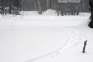
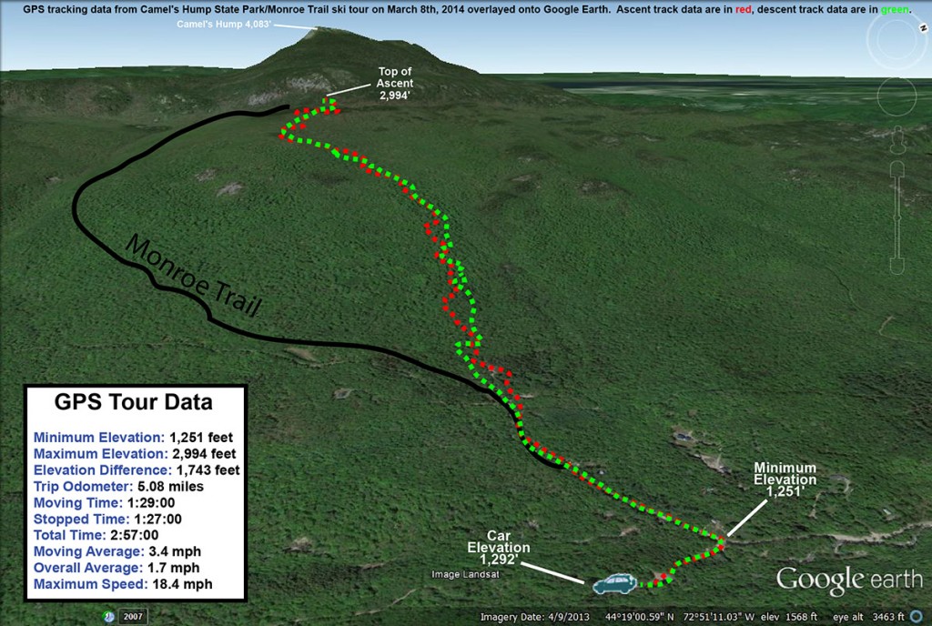
I headed out from the house a bit before noon, and temperatures were in the mid 30s F. The temperature fell as I headed up Camel’s Hump Road, dropping to 31 F by the time I reached the winter parking area at ~1,200’. Just a couple hundred feet below the parking area, I’d seen the first flakes of snow from a small system that was expected to come through in the afternoon. From the trailhead at ~1,500’, I skinned up the Monroe Trail for a few more minutes and then as the trail started to bend southward, I jumped onto one of the ski tracks coming down out of the obvious glades in the terrain above. The tracks traversed northward for a bit, but then gradually began to make a more direct ascent up toward the east face of Camel’s Hump. I was a little worried about the snow quality, because although it was below freezing and most snow that wasn’t in the sun was still wintry and dry, there were only a few inches of powder above an old crust. I wasn’t quite sure how that was going to ski. But, the snow got better and better as I ascended, with the powder on top of any crust getting deeper and deeper. It was really nice skinning though – the temperatures were just below freezing, the wind was calm, and light snow was falling in association with the afternoon’s storm. I hiked in just a vest over my polypropylene base layer, and quickly had my hat off as well.
As I ascended, it became obvious that the lower parts of the glades represented a common track to regain the Monroe Trail, but in the higher elevations, there were a number of interconnected glades from which to choose. About halfway through the ascent, I stuck with a glade that was generally on the skier’s right of the area that had seen very little traffic. There was just one very old descent track in it, and that track was actually hard to find at times because so much snow had fallen on it since it had been made. I knew that there were other glades around to my north, because I saw a couple of skiers descending in that area. After generally rejoining with tracks from some of the other glades, I traveled for a bit through more gently sloped terrain until I hit the trail for the Camel’s Hump Challenge at roughly 2,800’. I followed that northward a bit more until I topped out around the 3,000’ mark in some of the upper glades just below the Cliffs of Camel’s Hump. The quality of the snow had definitely improved up at that elevation, with any crust buried below several inches of powder.
I had a snack, switched my gear over, and then began my descent. There were some decent turns above the Camel’s Hump Challenge Trail, but the best turns were definitely when I got onto that lesser used glade below that point. The highest quality snow was in the top half of the vertical, and with my fat skis it was generally soft, bottomless turns. On the lower half of the descent, even my fat skis weren’t enough to always keep me floating, as the depth of the powder decreased to just a few inches; to best handle any partially tracked and/or narrower sections of terrain, I had to inject a lot more alpine turns into the mix vs. just Telemark turns. I did venture off the main glade that I was on at times, and there was plenty of skiing to be had right in the natural trees all around. I saw one other skier as I was descending – he was ascending through the glades as I’d done. He and his dog moved out of the way when he saw me off in the trees beyond the glade, but after I let him know that I was solo and nobody else would be coming down behind me, he quickly resumed his ascent.
Just as I’d experienced on my last outing in the area, from the bottom of the glades it was an easy downhill ski on the Monroe Trail itself. I was even able to catch some turns in the powder off to the side of the snow-covered roadway below the trailhead, then shouldered my skis to walk the last tenth of a mile back to the parking area. The temperature was 31 F just as it had been when I arrived, and the light snow had mostly tapered off down at that elevation. Despite the deeper snow and lack of a defined skin track in the glades relative to the beautifully packed nature of the Monroe Trail, I almost wonder if it’s more efficient to ascend in some cases because it’s a much shorter distance due to the way the Monroe Trail wraps around so far to the south. In terms of preserving the powder and ascending if the unconsolidated snow is deep and there aren’t many descent tracks, the Monroe Trail is the way to go, but now that I’ve gone up via both routes, I’d say they are both pretty convenient options. Hopefully I can get E and the boys along on one of these Monroe Trail trips – now that I’ve had a couple of sessions out there, I think I could guide them on a great tour.


Hey would you mind shooting me the gps file for your Monroe/CH trip? A couple of us are going tomorrow and bringing my dog so would like to find that skin track up if visible (sounds like others may ascend where you did). I have been before up Monroe then down thru those woods want to stay clear of Monroe if there is any open water my dog will find it get his paws iced up and screw up our trip!
Thanks,
Dave
No problem Dave; it won’t be hard to find that ascent route though unless nobody has skied there in a while. Typically the route is obvious because you can see all the descent tracks of skiers and boarders off to right as they rejoin the Monroe Trail. A few minutes after you begin the ascent on the Monroe Trail, be on the lookout for tracks off to the right as the trail begins to bend more to the left. Others were using that ascent route instead of the Monroe itself when I was last there, probably because it’s more direct and you can get a sense for the ski terrain while ascending.