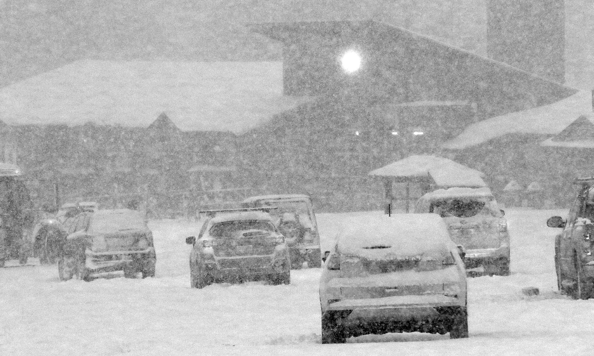
With the warm weather regime we’ve been in over the past few weeks, it’s actually been a month since I’ve heard of any snow in the Green Mountains – September 16th was when we had that cold shot that produced some flakes. We saw some frosty nights at the beginning of the month, but there was no precipitation with that cold air. However, new reports of snow have been coming in today. Over at the Americanwx.com New England regional forum, Powderfreak got a report of snow squalls atop Camel’s Hump, there was a report of various forms of mixed precipitation on Mt. Mansfield, and there was also a report of frozen precipitation from near the Pinkham Notch area over in New Hampshire. Not surprisingly, Mt. Washington picked up some accumulating snow, with 1.2 inches reported for the day.
Another round of frost and freeze warnings for Vermont
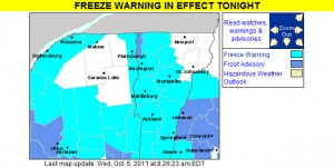
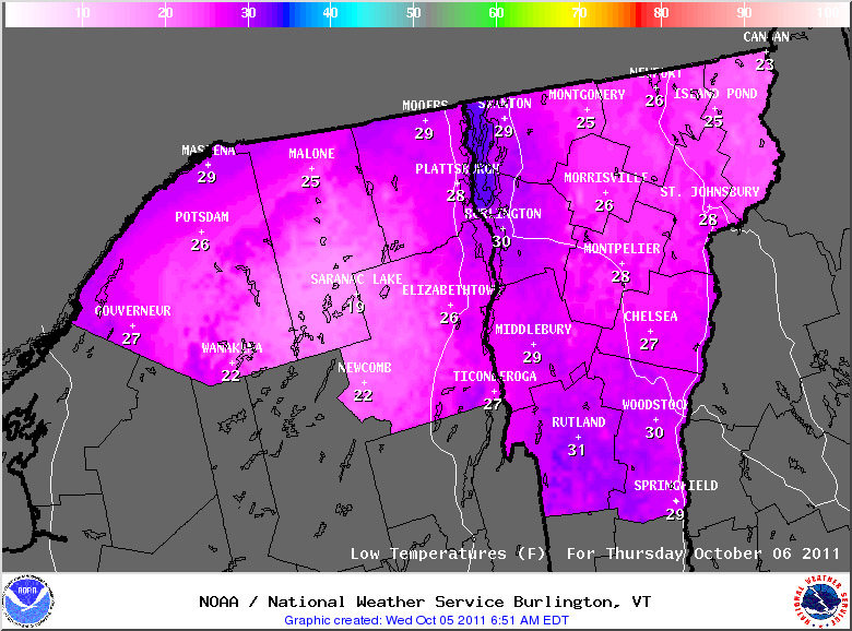
We’ve got another batch of cold air moving in over the next couple of days, so the National Weather Service Office in Burlington has put up freeze warnings throughout the area. Temperatures should be colder than last round with most areas in the 20s F, but since we’re into October now, that’s not all that surprising. For those areas like the Northeast Kingdom and the Adirondacks that don’t have warnings up, it’s because they aren’t needed; for those colder areas with early dates for the typical first frost, the growing season is considered to be over already. This is bad news for farmers in that area. Unfortunately, the weather cannot be changed. This will probably impact the crops of many farmers. To prevent this from happening next year, some farmers may want to take some extra precautions. Some may want to visit https://shrinkwrapcontainments.com/t-reinforcedblackout.aspx, for example, to purchase some light deprivation tarp. This is currently being used by full-time farmers in other areas who are trying to extend the growing season by creating artificial growing conditions. This tricks the crops, allowing them to continue growing for longer. Hopefully, this should help more farmers to have a successful growing season next year.
Some of the details from the National Weather Service have been added below:
434 AM EDT WED OCT 5 2011
…FREEZE WARNING IN EFFECT FROM MIDNIGHT TONIGHT TO 8 AM EDT THURSDAY…
THE NATIONAL WEATHER SERVICE IN BURLINGTON HAS ISSUED A FREEZE WARNING…WHICH IS IN EFFECT FROM MIDNIGHT TONIGHT TO 8 AM EDT THURSDAY.
* LOCATIONS…ALL OF VERMONT…EXCEPT CALEDONIA…ESSEX…GRAND ISLE AND ORLEANS COUNTIES. THE SAINT LAWRENCE VALLEY IN NORTHERN NEW YORK.
* HAZARDS…WIDESPREAD FROST AND BELOW FREEZING TEMPERATURES.
* TEMPERATURES…MAINLY IN THE MID TO UPPER 20S.
* TIMING…FROM AROUND MIDNIGHT TONIGHT THROUGH 8 AM EDT THURSDAY.
* IMPACTS…WIDESPREAD FREEZING TEMPERATURES WILL BRING AN END TO THE GROWING SEASON FOR ANY UNPROTECTED PLANTS OR VEGETATION.
First snow of the season for the mountains of Northern New England
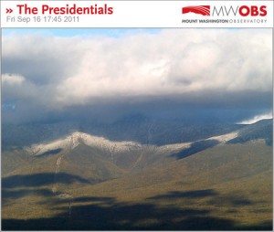
In association with our coldest weather of the season thus far, the mountains of Northern New England saw some snow today. In Vermont, I heard about the frozen precipitation on Mt. Mansfield in a post from Powderfreak at Americanwx.com, and over in the Presidential Range of New Hampshire there were some visible accumulations above the 3,500’ to 4,000’ elevation level. A great video from TheAutoRoad with scenes of snow falling along the Mt. Washington Auto Road was posted, and can be viewed below. Even in the valleys the weather was quite cool today, with highs only in the 50s F, so the look and feel of fall was all around us. Enjoy the video!
Frost and Freeze alerts posted for Vermont
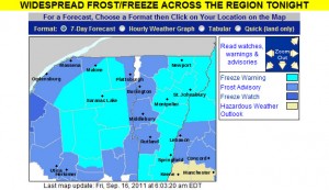
The National Weather Service office in Burlington has posted a freeze warning for our area, and indeed the entire state of Vermont is under either freeze warnings or frost advisories, so cover up vegetation as necessary. This may also be a good time to look into local furnace maintenance services as you want to be sure your current furnace can meet the demands of this cold weather. Companies like CJS Heating offer such services. Why now? Well, furnaces have to work much harder when the weather is colder and so some may struggle to keep up. The last thing you’d want is for it to stop working whilst temperatures are so low. Though the first frost for valley locations in the Central and Northern Green Mountains does typically happen in September, the average date for the occurrence is toward the end of the month (September 27th for Morrisville and September 30th for Montpelier) so this is a bit on the earlier side. Yesterday in the Northern New England thread at Americanwx.com, Powderfreak posted the chart from the National Weather Service that shows the average dates and ranges for first frost at some of our Vermont climate locations – mid September is in the 10th – 25th percentile. Take a look at that post for more information about average dates of 32 F temperatures around the state.
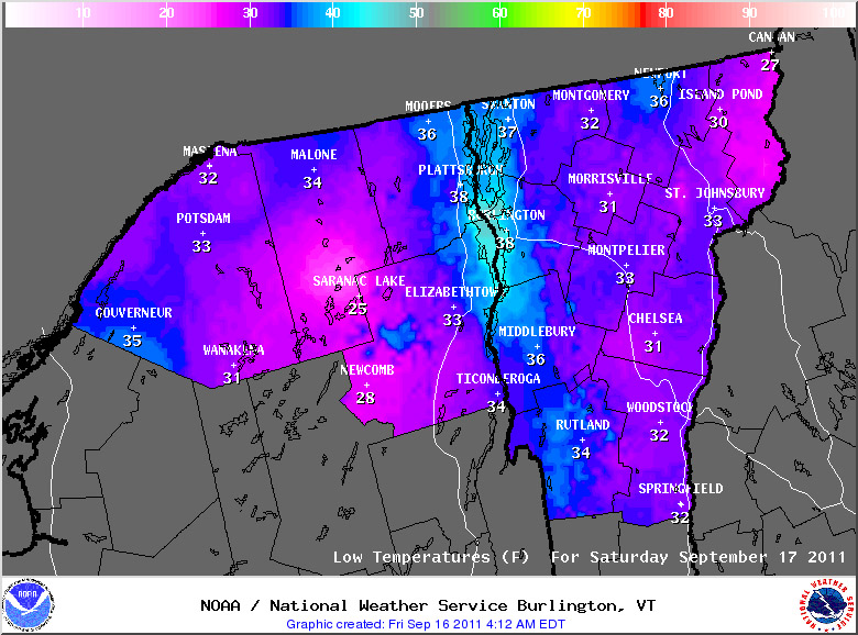
Potential for a little September snow in the Northern Greens?
It’s that time of year again when we start to think more about the colder weather, and for the past few days our NWS point forecast for Waterbury has shown sub-freezing low temperatures at the end of the week. Talk about the first snowfall of the upcoming season, has already begun – over in the New England forum at Americanwx.com, Dryslot pointed out the potential snow showers and frost in the forecast from the National Weather Service office in Portland, Maine. This morning I saw that there is a cold weather update at the Famous Internet Skiers website, and on SkiVT-L, there was a visit from Roger Hill, who threw out the potential for a little snow accumulation at Jay Peak. Although it doesn’t seem to be the case this time, I’m certainly reminded of a couple of seasons ago when some September snowfall actually produced enough snow to get in some skiing. The past couple of days have been pleasantly summery, even up here in Northern Vermont, but it sounds like the crisp feel of autumn is on our doorstep.
June upslope rain, with some snow for the mountains
After drying out to amazing low humidity on Wednesday, temperatures got really cool on Thursday and we got into a classic Northern Vermont upslope flow. There was actually some snow falling in the highest elevations of the Greens, and certainly over in the Whites. There were just a few spits of rain in Burlington when I left yesterday afternoon, but of course I got to the house and it was a steady light rain with a tenth or two of an inch already in the gauge. This morning the gauge contained 0.27” of liquid in it and I thought, heck, that’s a half foot of upslope snow right there when the temperatures are appropriate. I was looking at the radar image posted by Powderfreak at Americanwx.com and could see how at one point it exploded with 35 db and even a few 40 db echoes over our area at the junction of I-89 and the Chittenden/Washington county line, and then dissipated on the east side of the mountains once it dropped its payload:
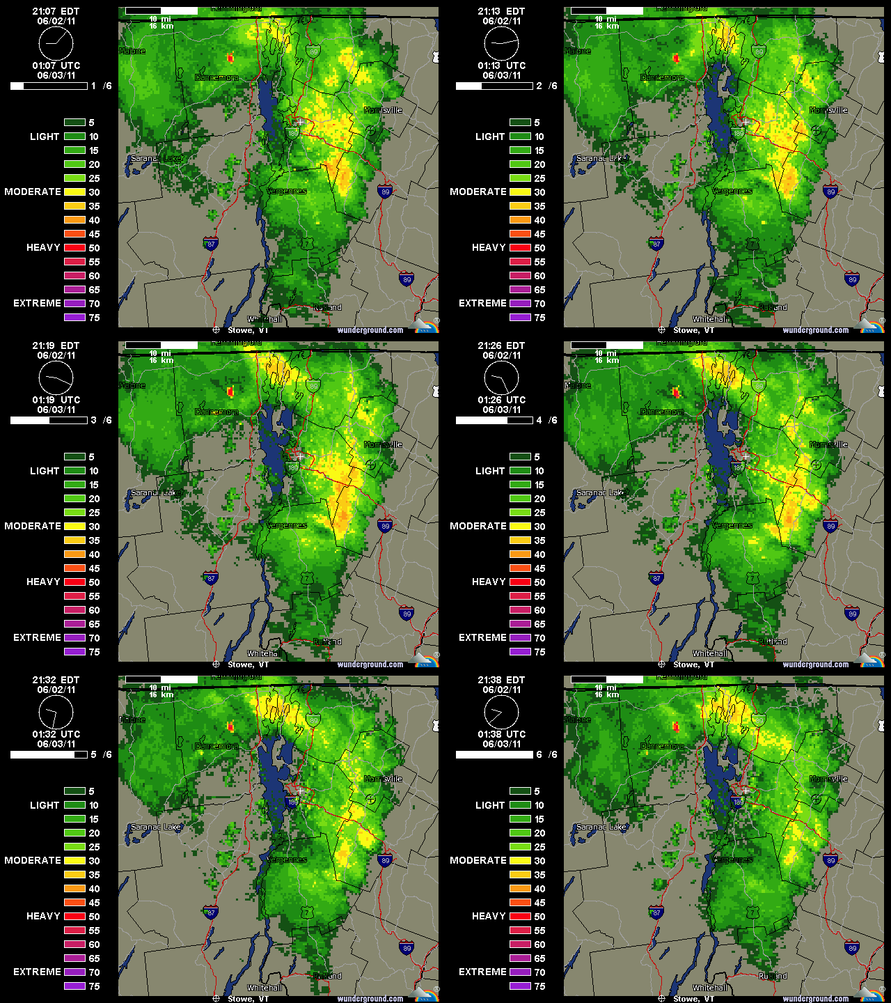
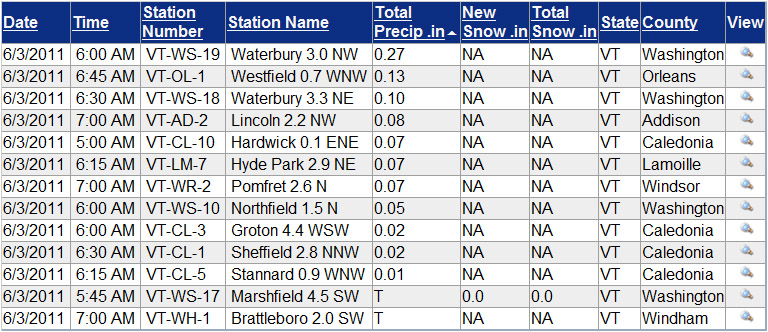
When I submitted my report to CoCoRaHS this morning, I took a quick look at what some of the other stations had reported. I sorted the list below from around 7:00 A.M. by total precipitation, but even without that, it was pretty easy to see the locations that got the liquid:
I haven’t been able to check out the local peaks to see if they have any white on them because they’ve been socked in, but Mt. Washington got some new snow and they must have been whitened. It’s 26 F up there now with freezing fog and 50+ MPH winds. With such a good-looking forecast for tomorrow, we may head over for some turns, but these past couple of days certainly should have been good for snow preservation.
Thunderstorms and some heavy rains overnight
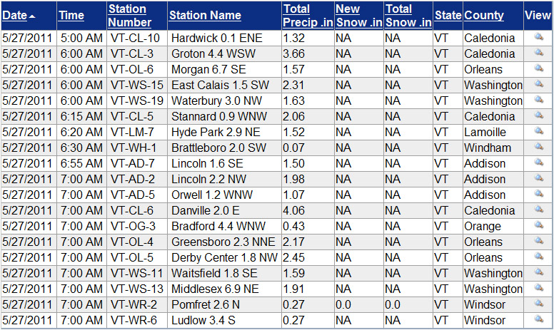
It didn’t seem like it rained a lot last night, but I found 1.63” in the gauge this morning, so it obviously added up. We had some losses of power similar to what Powderfreak noted – a couple short ones in the evening, and then it went back out again around 8:00 P.M. and it was gone for the night. It came back on early this morning at some point. I didn’t stay awake for it, but apparently we had thunder and lightning pretty continuously through about 2:00 A.M. This morning I was surprised to see the Winooski way back up to a level even with our local V.A.S.T. bridge and hogging almost the entire valley in our area, just like back in mid April when the snowpack was starting to melt. I think it may have even been a bit higher this time, as the typically flooded residences and farmland west of the Cider House seemed quite inundated with water. The water was probably the closest I’ve seen it to washing over Route 2 in that area – I think another foot of depth and there would have been water on the road. I was surprised it got so high relative to the amount of water I recorded in the gauge, but then I checked the CoCoRaHS maps and saw that one observer over in Caledonia County reported 3.66” of water with this event. I don’t think they are actually in our drainage, but clearly someone out to our east got a load of water from these storms overnight. Our bus was late this morning due to road closures in the Montpelier area, so things have certainly been disrupted by the water. I added an image of the VT CoCoRaHS table of Daily Precipitations Reports as of ~7:30 A.M. this morning, and it indicates that someone over in Danville got over 4 inches of liquid from these storms, so there are reports of some large amounts of liquid coming in from Caledonia County.
Snow line around 1,500′ this morning
It was ~41 F at the house this morning, so I suspected that the snow level was still a bit high for new powder in the easily accessible elevations, but I checked in at Bolton on the way in to Burlington this morning to get a handle on where things were at in terms of base and new snow. I could tell that it wasn’t yet a huge hit below 2,500’ yet because the cars coming down the road didn’t have snow on them, but the precipitation certainly looked like snow up high. Here’s the vertical temperature profile I observed on the Bolton Valley access road around 7:00 A.M. with comments on the precipitation/accumulation; hopefully it will be useful for other mountain recreationalists:
340’: 41F (light rain)
950’: 40F (light/moderate rain)
1,100’: 39F (moderate rain)
1,500’: 38F (moderate rain/snow)
1,800’: 37F (moderate snow)
2,000’: 36F (moderate snow)
2,100’: 35F (moderate snow, accumulating)
As you can see from the above list, snow wasn’t accumulating until I reached the village at 2,100’, but it seemed to be accumulating on most surfaces other than the pavement, and there was probably ¼ inch down when I was there. Skier’s left of Beech Seal showed a couple of breaks in coverage, as I suspected it would based on my Sunday observations, but it was still pretty close to continuous.
Even back down in the valley, there were some bouts of moderate precipitation, so hopefully that continues to hit the mountains. Roger Hill was thinking that the snow level would rise a bit during the day today, so that may have to be factored in as well.
Heavy rainfall and more high water today
I haven’t seen any snow with this system, but last night’s precipitation seems worthy of note because we had 2.30 inches of liquid and the Winooski is back up even with our local VAST bridge as it was on the 11th, despite the fact that most of the snow has already melted in the lower elevations. Some area schools are closed due to road access issues with this event. I just summed my CoCoRaHS numbers for April and with this latest event the total liquid is right at 8.00 inches for the month thus far. While I had that open I grabbed a few additional liquid numbers. For the 2011 calendar year up to this point at my reporting location the liquid precipitation is at 20.46 inches, for the 2010 calendar year the total was 54.17 inches, and for the ’10-’11 snowfall season as it currently stands (October 15th, 2010 – April 16th, 2011), the total was 28.09 inches.
The snow in the yard has melted
The last of the snow in the yard melted today, so I can finish off that portion of my seasonal snowfall numbers. The data for the last of the snow melting out in the yard (as of this season the mean date is April 15th ± 10 days) is actually something I’ve recorded all the way back since our first winter here (2006-2007) and April 24th is one day later than the previous record I had down (April 23rd, 2007). This puts the continuous snowpack season in the yard at 141 days, which is exactly the same number recorded for ’06-’07. Both of those seasons had slow starts with poor November snowfall, and snowpack that did not become established until early December, so they are well behind the highest value of 152 days recorded for the 2007-2008 season. The next benchmark I’ll monitor will be when the last of the snow melts out in our neighborhood, which tends to be about a week beyond when the snow melts out at the house.
As I was skiing at Bolton yesterday I was reminded of some outings in April ’07, and realized that while the snowpack is in excellent shape this spring, the skiing this month has really paled in comparison to the equivalent period back in ’07. Even down at this elevation we had almost two feet of snowfall in April ’07, and this season we’ve had just 4.4 inches. I’m not sure what the mountains have had this April, but in ’07 it was measured in feet; I skied one day mid month on the mountain where I found up to 19 inches of new snow, and that was for just one of the storms. The reading from the Mansfield stake on Friday was certainly respectable at 82 inches, but for the same date in ’07 it was actually at 84 inches. It’s really been just an issue of the storm track this April; the moisture has been there, but the track has been too far to the north/west to get into the appropriate combination of precipitation and temperature. With a good track over the past few weeks we probably would have had another April 2007 on our hands. I think that the past couple of springs have been so poor in the snowfall department that some perspective has been lost on April’s potential, this one is good in terms of base/snowpack, but I’d say subpar for snowfall (we’re still below average by a few inches at the house).
