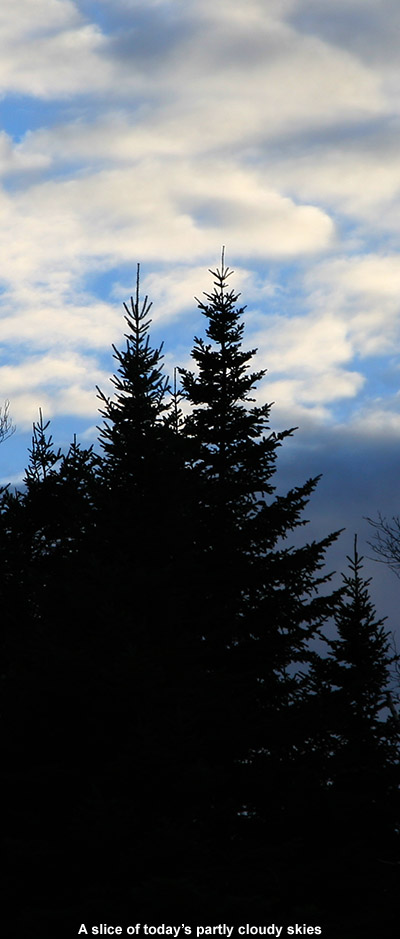
We’ve been hearing mentions of snow in the recent weather forecasts, mostly about how we’re getting close to those temperatures where the mountains can start to see flakes, and today I saw the first reports of snow up in the higher elevations. One of the engineers manning the broadcast equipment up on Mt. Mansfield snapped a picture of some of the flakes falling to document the first Vermont snow of the season. It’s not too surprising, with Mt. Mansfield close to the freezing mark this morning along the ridge line. A bit higher up, the summit of Mt. Washington in New Hampshire is sub freezing at this point. It’s October now, and although it looks like we’ll have plenty of nice weather coming over the next week, it’s the time of year when the mountains can start getting snow at any time, so we’ll be on the lookout for upcoming snow chances.
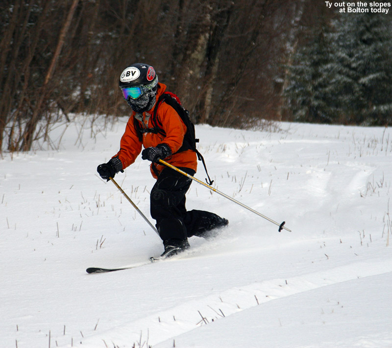
Bolton Valley, VT 01DEC2013
The ski tour we took yesterday was certainly considered a success, since both E and Ty were saying positive things today, and Ty was expressing to Dylan that he missed out on some fun. With the prospects for a little more snow today from a passing Alberta Clipper, I figured another visit to the mountain was in order, and I decided to make it at the end of the day once the new snow had started to accumulate and top off the powder. I couldn’t quite convince anyone else to come with me since they were having too much fun sledding or doing other stuff, so it was another solo outing.
I wasn’t exactly sure when the snow was supposed to start, but eventually it looked like I was going to run out of light, so around 3:00 P.M. I finally headed out. Fortunately, flakes had just started falling in the valley, so I knew the snow would already be well underway up on the hill. Up at Bolton Valley, the temperature in the Village at 2,100’ was 30 F and a steady light snow was coming down. The flakes weren’t huge, but it was accumulating on my equipment quickly enough that gear left out took on a coating within a minute or two.
“Fanny Hill ultimately lost
out to Work Road because
the snow was just too
good – 6 to 8 inches of
fluff and hardly a track.”
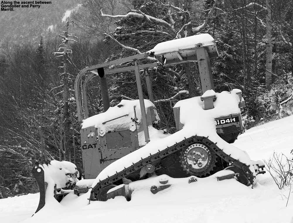
After using Turnpike for the past couple of ascents, and seeing that skier traffic there had been decent, I decided to go for an alternative ascent route up through the Fanny Hill area. It would give me a chance to check out the skiing in that area, and still head over toward the Wilderness Lift Line if I didn’t find anything that seemed to top what we skied yesterday. My first interesting sight was right as I was starting my ascent on Lower Fanny Hill – on one of the small cross trails there was a group of folks hanging out in a protected nook in the trees, just sitting in a circle of chairs and chatting. I suspect they were from the Liftline Condos that were just beyond. There was no wind, so with the light snow falling and temperatures around 30 F, it was indeed a fun time to be outside; it just seemed like a fitting thing to be doing on a dark Sunday afternoon in December.
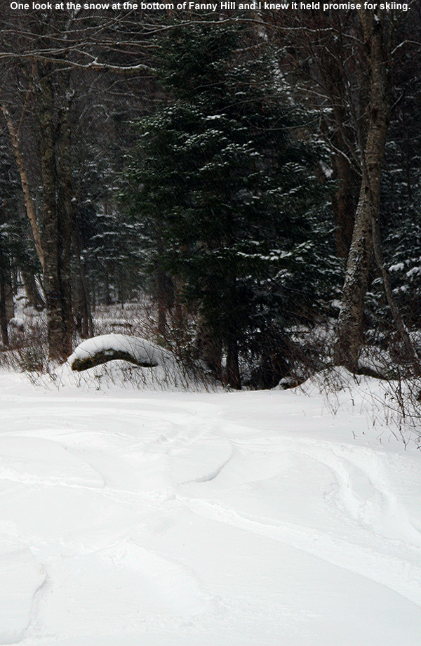
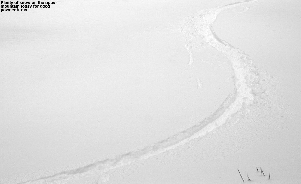
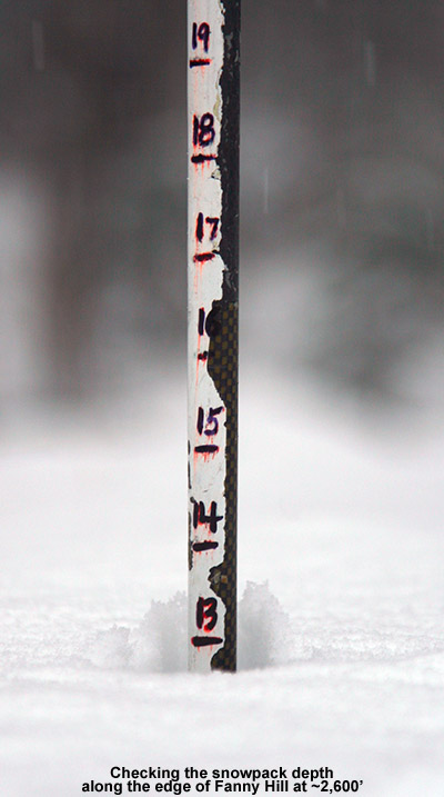 Upon reaching Fanny Hill, the snow looked good, so I decided to continue my ascent there and explore the surfaces further. In general there were the same several inches of powder above the base snow that we’d encountered on the Wilderness Lift Line yesterday, and only when I got into the steeper sections of terrain near the top did the pitch seem to be too much for the snowpack. In a nice undisturbed spot along the edge of the trail at 2,600’, I was able to check the full snowpack at that elevation, and that came in at 13”. I’d say that consisted of a 6” base, and the rest was powder on top
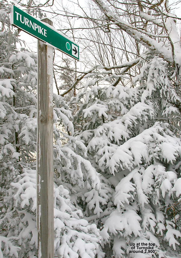
I continued up toward Upper Fanny Hill, generally staying away from the Sherman’s Pass area where I could hear the snow guns running. Those higher trails like Coyote, Work Road, Lower Crossover, and Swing, held deeper snow and had seen much less traffic. They were definitely going to be on my descent route. I stopped my ascent around 2,900’ on Upper Fanny Hill just before the steepest pitches, because I could see that they were somewhat windswept and just didn’t have the coverage they needed yet.
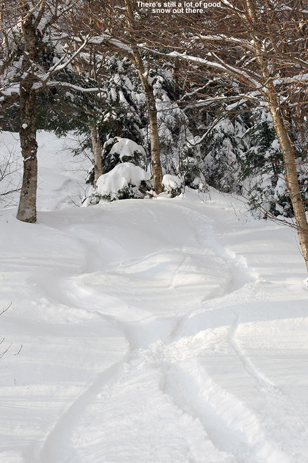
I played it by ear on the descent, just watching for those trails with deep snow that had seen minimal traffic. Fanny Hill ultimately lost out to Work Road because the snow was just too good – 6 to 8 inches of fluff and hardly a track. That brought me over to the Wilderness Lift Line, and since we’d skied the skier’s right yesterday, I took the skier’s left today and found the same type of good snow. I’m sure Fanny Hill would have been fine as well, but after committing to Work Road I went where gravity took me. The rest of the descent back to the Village was just like yesterday, good soft snow, so no complaints.
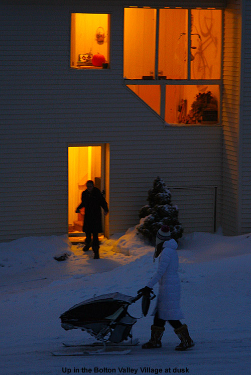
It was getting pretty dark when I was leaving, but the group of folks was still hanging out in their little alcove in the trees – it was a good spot. As I made my way along some of the Liftline Condos, I saw a woman pushing something along through the snow – she made her way through some of the deeper snow around the back of the condos, and then was out of view for a bit before she got onto the street and I could get a picture I didn’t know if it was a stroller, or just some other sort of vehicle for moving things, but whatever the case, the fact that it was on skis was intriguing. Clearly it seemed to be somebody who knows the Bolton Valley environment.
It snowed all the way down to the valley when I was heading back to the house around 5:00 P.M., and the temperatures had fallen below the freezing mark even at the bottom of the access road down at 340’. It looks like the next opportunities for snow are some light stuff in the early week, and then a frontal system later in the week.
Bolton Valley, VT 30NOV2013
For the valleys in Northern Vermont, our first big winter storm of the season hit the area this week, and it created some potential holiday travel woes because of its occurrence so close to Thanksgiving. The storm was essentially complete by the time we traveled on Thanksgiving Day, but with 8.2 inches of snow, and 1.62 inches of liquid equivalent, it had certainly bolstered the snowpack in the yard and changed the look of the landscape. While the storm did have some mixed precipitation and rain in the middle, it was quite a nice gain in snow for the mountains, with some of the ski areas in the Northern Greens picking up more than foot of snow. And, as is often the case, the final volley from the storm consisted of a good shot of dry powder that sat well atop some newly added dense base to create some great Thanksgiving Day skiing.
With our holiday traveling done, we finally had the chance to get out today and sample some of the new snow. Dylan was away at a friend’s house, but E, Ty, and I headed up to Bolton Valley to earn some turns. They had reported 9 inches of new snow for Thanksgiving morning, and as we headed up to the Village, we stopped in at the base of Timberline at 1,500’ to check on how the snow had settled in down at that elevation. The depth of the powder was 3 to 4 inches over a good base, and we could see that there had been plenty of ski activity on Timberline’s slopes. Continuing on up to the Village at 2,100’, we found that the snow had increased to 4 to 6 inches in depth.
“The powder skiing was
every bit as good as
what I’d experienced
on Sunday…”
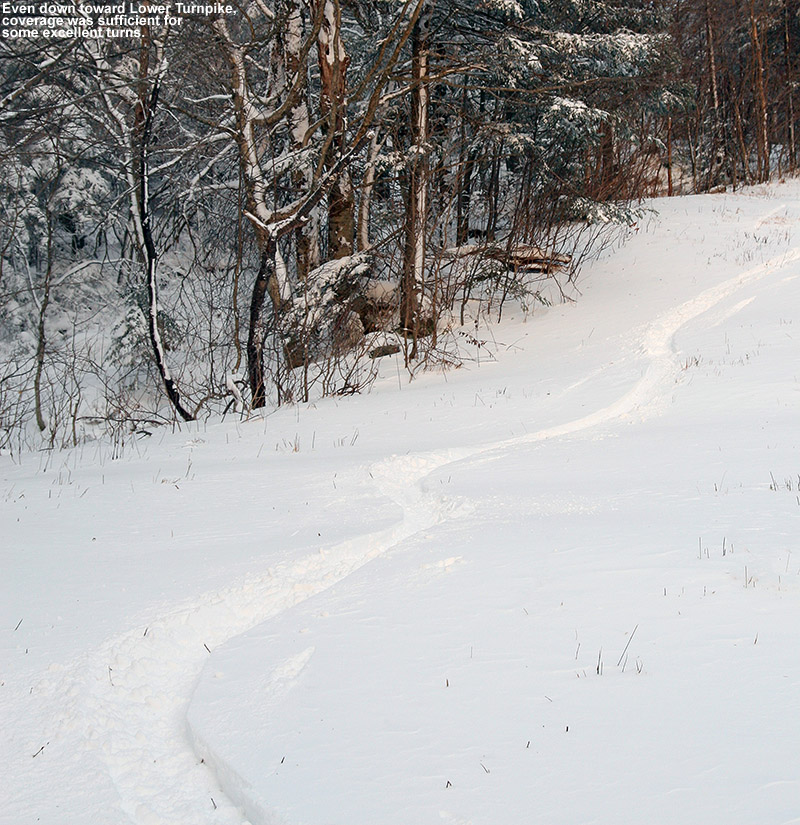
Having experienced some good snow on Turnpike on Sunday, I figured that we would check that out again today. Of course, with it being two to three days since the snow fell, plenty of skiers and snowboarders had been out on the trail, a lot more than the single track I’d seen on my last trip. We were treated to a nice skin track, but most of the powder was tracked out, so we definitely kept our eyes open on the ascent for lesser used options. We ran into Cam at the top of Lower Turnpike, and chatted about the mountain’s opening in a couple of weeks. If we can stick with the current weather pattern, things are looking quite good.
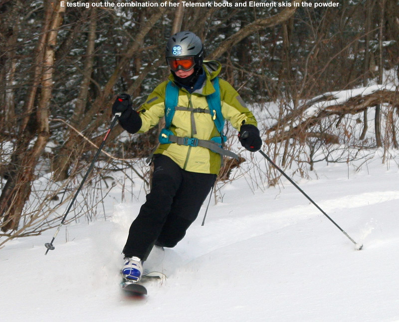
Like I’d done on Sunday, we stopped our ascent around 2,900’ on Turnpike since the terrain above that level was rather windswept, but snow depths had increased to roughly 6 to 8 inches, and combined with the base, there was easily over a foot of snow sitting there in many places. On the ascent I’d looked at the snow on Cougar and the Wilderness Lift Line, and I’d seen only a couple of tracks, so we worked those into our descent. The powder skiing was every bit as good as what I’d experienced on Sunday, and I was glad that we found plenty of untracked snow for Ty and E. Ty was putting together some great turns on his Teles, and I think his skiing was helped by the fact that he was in high spirits. E had her first chance to get on her Element skis with her new Telemark boots, and she definitely felt a big increase in control that she’d previously lacked with on her fat skis with her old boots.
Today was a great, mellow outing, just like you’d expect pre-season at Bolton Valley. Along with Cam, we saw a couple other pairs of skiers, and they all appeared to be experiencing that same vibe. We’ve actually got our next small storm coming through tonight, and it’s supposed to persist into tomorrow, so perhaps we’ll get a freshening of the powder that will set things up for more turns. It’s been a great November of skiing around here, and now it’s on to December – let’s hope it can follow suit.
Bolton Valley, VT 24NOV2013
I hadn’t yet been up to Bolton Valley for turns this season, because based on what the web cams have been showing for all the storms thus far, the slopes at Stowe have seen bigger accumulations and better coverage. This time around though, things seemed more equitable. I’d seen the general state of coverage at Stowe when I stopped there for a tour on Thursday, so I had a good idea of what was down after the additional 4 to 6 inches reported this morning due to the recent Alberta Clipper. I could see from the Bolton Valley Live Web Cam that, although there was definitely some wind pushing the snow around and scouring some areas, accumulations were at least in the same ballpark as what Stowe had seen. As long as I went for a protected section of the mountain, it looked like coverage was going to be sufficient for some good powder turns.
“If you’ve ever heard of
the ‘no chain’ expression
in cycling, for when the
pedaling seems effortless,
then the expression for
today’s ski outing would
be ‘no width’.”
I wasn’t initially sure if I’d want to head out to the slopes today, since just a few inches of snow were expected from the clipper, but more due to the fact that the coldest air of the season has moved in on the back of this storm. With significant winds as well, it sounded like it was going to be brutal out there on the mountain. The reality was though, that this was November cold, not January cold. When we were out in the yard early this afternoon taking some potential Christmas card photos, the temperature was in the low 20s F and it was reasonably comfortable. It was going to be colder and windy on the mountain, but it seemed like great weather for earned turns.
I headed up to the mountain in the mid afternoon, made a quick Timberline stop at 1,500’ to measure the snow depths, finding 2-4”, and then parked in the top tier of the village lot around 2,100’. The temperature was in the mid teens F, and snow depths had increased to around 4-5”. After a conversation with Quinn subsequent to one of our recent October snowstorms, he’d mentioned going for an outing on the Turnpike trail, and with today’s accumulations and wind, that sounded like the perfect, protected option for an afternoon ski tour. I found a nice skin track that had been set in place by a prior skier, and it brought me up through some beautifully protected terrain. I think this was actually my first time ascending Turnpike on skins, and it is indeed a nice route. It’s got that type of modest pitch that makes you feel like you’re out for a stroll and hardly doing any work. The coverage was looking decent, and there was even a bit of old base snow that was initially sporadic, but increased as I got higher on the mountain. At 2,500’ I found snow depths in the 5-7” range, and I continued to follow the skin track up to around the 2,800’ mark, where it terminated. My plan was to ascend as high as the quality of the snow dictated, stopping when the winds or terrain outweighed the elevational increase in accumulations. Whoever had made that skin track had the right idea, because at 2,800’ it was starting to get to that point. I pushed on to 2,900’ at the top of Turnpike, and called it there because the next pitches on Peggy Dow’s were clearly steeper, rockier, and exposed to the wind. The snow had definitely been getting deeper though, and I’d say the depth of the powder up there was 7” or more.
I was unsure exactly how the descent was going to go. I’d chosen Turnpike because it has that protection from the wind, but also a nice combination of blue/green pitch and a generally grassy, not rocky, surface. The new snow was quite dry, but I’d brought my fattest Tele boards, my AMPerages at 115 mm underfoot. I was banking on that width to keep me afloat. I dropped in for my first turns, and another aspect of the snow conditions quickly became apparent… the snow was indeed light and dry, but it was cold enough that it was also slow. I was worried that the lack of glide in the dry snow was really going to affect the descent, but as soon as I hit the first steeper pitch the turns started flowing. Coverage was definitely adequate, and I touched down on the old base or grass very infrequently. Turns were very smooth, and as I was gliding my way down, I was confident that I’d made the right ski choice for the day. In fact, it felt like the perfect ski choice, and amazingly, given the situation I think I would have gone even fatter with the skis.
People are always pushing the fattest skis for the deepest powder, and that definitely makes sense in terms of floatation, but they’re good for so much more. Indeed I find them absolutely horrible on firm snow; it’s a lot like trying to ride a snowboard on a hard surface. But today didn’t have anything to do with firm snow, it was all powder… light, dry powder, and the fatties shone in just modest depths in multiple ways because of their floatation. First, despite the airy snow, they were keeping me off the subsurface and allowing bottomless turns. Second, and this one was totally unanticipated prior to discovering how dry and slow the snow was, they were allowing me to plane at the more modest speeds attained on today’s moderate pitches. That kept me going on lower angle pitches, really enhancing the fun factor, and it’s been one of the few times when I’ve had the feeling that even wider skis wouldn’t have been overkill. If you’ve ever heard of the “no chain” expression in cycling, for when the pedaling seems effortless, then the expression for today’s ski outing would be “no width”. Even though it was all Telemark turns, in which transitions are much slower than alpine, things seemed to move effortlessly from edge to edge during the turns, and it all just flowed.
Looking ahead, we’ve got a small system expected to affect the area tomorrow night with some snow, and then a much more significant system as we move toward Thanksgiving. That one could be messy with some mixed precipitation, but hopefully we’ll get some snow out of it as well.


Stowe, VT 21NOV2013
We were last out at Stowe for turns on Sunday, and since that time there really hasn’t been much in the way of new snow – about an inch fell at 1,500’ on Tuesday, with probably a couple of inches up near the Mansfield ridgeline. That wasn’t much to inspire one with thoughts of great ski conditions, but since I was in Morrisville today for the annual BJAMS Thanksgiving lunch, on the way home I decided to pay a visit to Mt. Mansfield and make use of the energy provided by that great meal.
“…the forecast suggests
that we’ve got three
potential systems moving
through in the next few
days…”
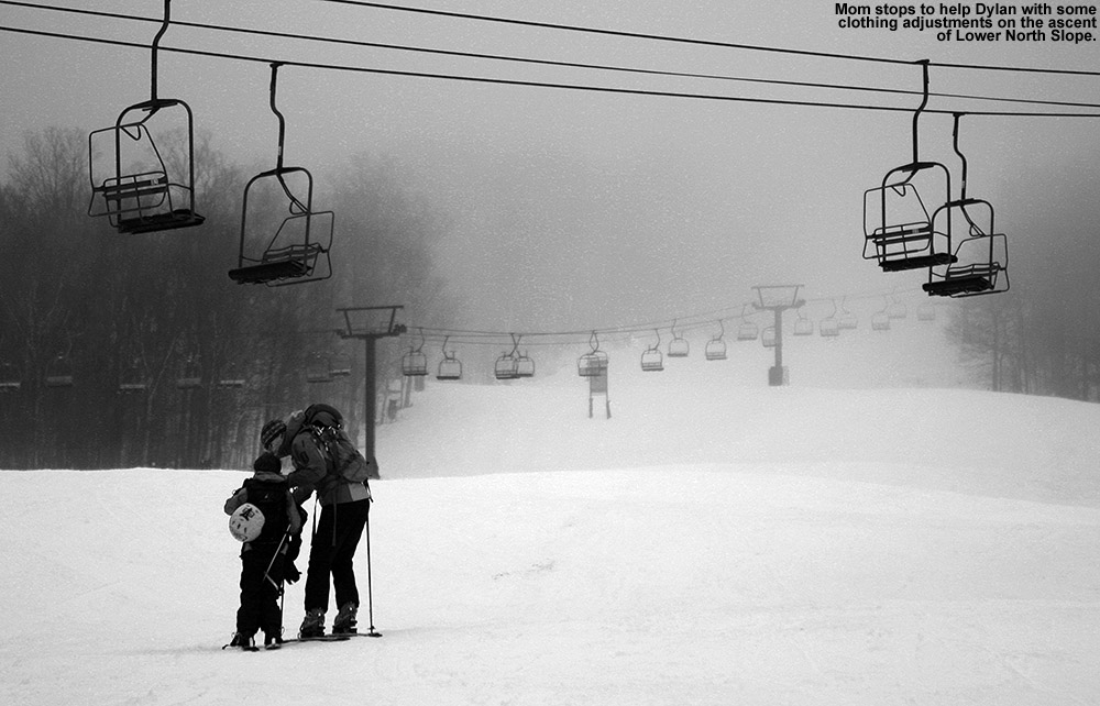
Temperatures that were in the teens this morning were hovering near 40 F in the mountain valleys and up at the Mansfield Base in the early afternoon. Although it was above freezing, the air seemed quite cold and there was no melting going on – the dew points were just sitting there down in the teens. I parked a bit north of the Mansfield Base Lodge, got my gear together and began skinning up toward Lower North Slope. With an inch or two of natural snow supplemented by some snowmaking blow-over, the look and feel of the snow on that first pitch above the parking lot was quite encouraging.
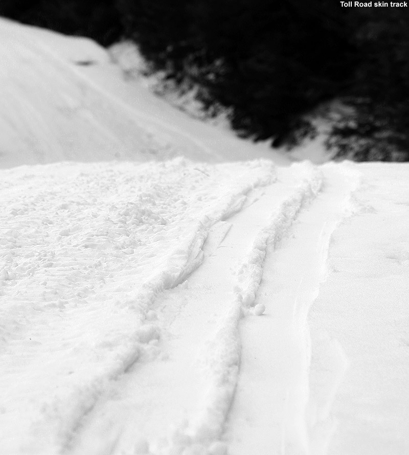 There was an occasional skier here or there on the slopes, but as one might expect on a pre-season midweek day without any obvious storms having gone through the area, it was pretty quiet. The snowmaking lines were definitely charged in many areas, but with the marginal temperatures, the guns seemed to be on hold. That kept the scene especially peaceful. I ascended at first via North Slope, and while Lower North Slope had seen a massive bombardment of manmade snow thanks to the cold temperatures, above Crossover the surface was a refrozen mess that had either seen snowcat/snowmobile traffic or previous skiers. The uneven surface was occasionally slick enough to cause some skin slippage on the steepest pitches, so at the top of the Mountain Triple at ~2,700’ I switched over to Toll Road for a change of pace. The skinning there was delightful, with a track recently made by another skier in a couple inches of powder. I continued on up Sunrise and Lower Ridgeview, and finally stopped my ascent at the next junction with Toll Road at 3,300’. Based on what I’d seen during my meandering climb of the mountain, I liked the prospects for starting out with some turns in the powder along the edges of Toll Road. In general, slopes that hadn’t seen fresh snowmaking were going to be a scratchy mess of refrozen corduroy, bumpy snow, or worse yet, snow that had been beaten up by the treads of machinery… and then solidified.
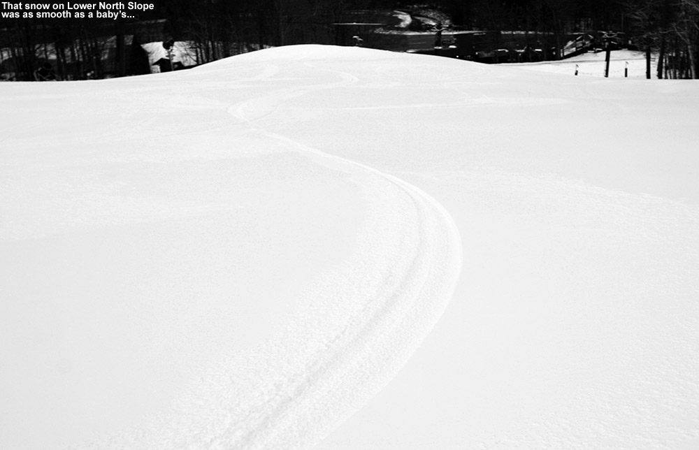
I started down Toll Road, and indeed the surface was as expected – where vehicles had traveled it was very disheveled, but fortunately the edges held frequent untouched powder of a couple inches that made for some smooth turns on the gentle pitches. Sunrise was steeper and held the occasional good pocket of powder off to the sides, but generally the scratchy, messy snow that marked the low end of today’s spectrum of conditions. However, when I found myself on Gulch I was greeted with some freshly-made snow that produced some great turns. There was quite a mix of options on Gulch, with turns on the manmade and occasional jaunts into the natural snow where nothing had been blown. Like Sunday, at Crossover I once again found myself looking down Lower Lord at some impressive snow – it was that mix of natural bolstered by manmade, and I got about 10 turns worth of good stuff before I cut through the trees over to Lower North Slope. Natural snow almost always trumps manmade snow, but for today, I actually might have to give top honors for most fun turns to that freshly-made stuff on Lower North Slope. Where it hadn’t been touched by any equipment, which was fortunately most of the slope, it was billiard table smooth – and it offered up turns just as smooth. You would shave off just a half inch or so of that snow and the turns were dreamy. The surface seemed so durable despite its softness, and it made me wonder how a non-groomed surface like that would hold up to skier traffic. It was a really fun way to finish off the run.
“…I actually might have
to give top honors for
most fun turns to that
freshly-made stuff on
Lower North Slope.”
So, although the base depths certainly aren’t up close to the two foot mark the way they were last week, the base of 7 inches or so up high is right around average – and we’re not talking about 7 inches of fluff, this is stuff that has already been consolidated by the warmer temperatures from earlier in the week. I think we’re going to see some interesting options in the higher elevations when natural snow moves in and starts to build upon what’s there. And, we may not have to wait long – the forecast suggests that we’ve got three potential systems moving through in the next few days, and possibly even a fourth, larger system, in the middle of next week. That one is still too far out in the modeling world to really be considered likely at this point, but it’s got people’s interest because it could be a coastal storm with more copious amounts of moisture. In any event, the first three events are much more likely, and should be almost exclusively snow in the mountains. I’m curious to see what we get out of these systems, because as we know, the Northern Greens can often take these smaller snow events, run with them, and deliver the goods.
Stowe, VT 17NOV2013
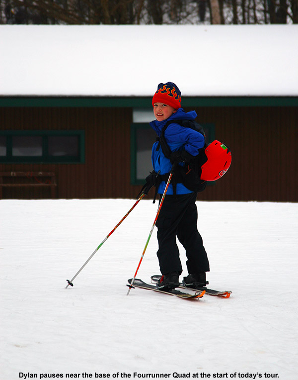
Stick season can be a tough time to get out for exercise; there are often those cold, dreary days in the 30s or 40s F that don’t really inspire one to jump on the bike or into the kayak. Instead of hitting the trail, it’s much easier to hunker down at home in the warmth. Fortunately in Northern New England, when the weather reaches such a cold and dreary level, there’s often fresh snow falling in the mountains. That wasn’t the case this weekend though, as the current storm affecting that area is fairly warm, and the precipitation isn’t expected to change over to snow until tomorrow night. With the weather at hand, there wasn’t much calling us out onto the slopes. However, since Stowe prepared some of their terrain and ran the Fourrunner Quad for season’s pass appreciation day yesterday, it meant that there would be some rather unutilized groomed snow out there today. That realization hadn’t even occurred to me until late morning when I was thinking about what we might do to get in some outdoor activity today. I brought up the idea to E and the boys, and once the house and homework were generally in order, we decided that we could spend a couple of hours getting in some turns.
“What I encountered was
an inch or two of dense
powder, it had seen some
contamination by manmade
snow, but that was enough
to keep me riding on a
smooth, supportive base.”
We headed out in the mid afternoon under cloudy skies and occasional spits of drizzle, finding temperatures in the mid 40s F in the mountain valleys. We’ve only got a couple patches of snow left at the house, and in general there’s really nothing to speak of for snow up the Mountain Road until you get around the 900-1,000 foot elevation. From there the snow builds until there’s decent cover at 1,200’ and above, but south-facing areas exposed to heavy sun are still partially melted out even up at those elevations. We parked at 1,500’ near the Mansfield Base Lodge, where, we saw a few other vehicles and one skier just starting to skin up toward the quad on their ascent. Temperatures were in the low 40s F and the snowpack looked quite respectable – there was a consistent covering of several inches or more, and the consolidated snow was only slightly softened by the above freezing temperatures. In fact, we were thinking it would have been nicer if it was softened even more with regard to making turns.
We skinned up to the base of the Fourrunner Quad and continued past it toward the bottom of Lower North Slope, which with its prodigious manmade snow was the obvious route that every other skier we saw was taking. There was really no skin track, nor was there need for one – the whole expanse of the slope was essentially a smooth mass of consolidated snow that you could walk through like a giant field of white. We spread out and often walked side by side, enjoying what was definitely a leisurely pace. We really didn’t have any goal for the ascent, we figured we’d just go as far as the quality of the snow and the availability of daylight suggested. We stopped for a quick break at the intersection with Crossover (~1,850’) – we were just starting to enter the clouds at that point and combined with the late afternoon light, visibility was very low. We continued on up Crossover to where it met Standard at around 2,000’ and decided to end the ascent there.
“I’ve been quite impressed
with their sushi so far, and
it was great again tonight.”
For the descent, we began our way down Crossover, finding the snow pretty much as we expected based on what we’d felt beneath our feet on the ascent and heard from the descents of other skiers. It was soft enough to get a nice bite with the edges, but not as soft as you’d really like it to be for spring skiing. Temperatures around 40 F just weren’t enough to get it to soften that far. Crossover has some irregularities in the surface from snowcat, snowmobile, and skier traffic, so it also wasn’t as smooth as if it had been freshly groomed. The snow had enough issues that it had me looking elsewhere, such as the natural snow on Lower Lord that I’d seen on my way up. As Powderfreak mentioned with regard to yesterday’s opening at the resort, even some natural terrain trails were open, and there was clearly enough coverage even down below the 2,000’ level to make that a reality. I decided to make a few turns down Lower Lord, just to check it out, and then I could shuffle back up to Crossover if the skiing was horrible. Well, those first few turns had me sold. What I encountered was an inch or two of dense powder, it had seen some contamination by manmade snow, but that was enough to keep me riding on a smooth, supportive base. I told E and the boys to dive in and check it out, and if they didn’t like it we could head back up. Everyone enjoyed the snow – the only thing was the after a few more turns, the extra density that had been imparted by the manmade snow disappeared. The powder became much wetter and the base less supportive. We made a few more turns before deciding to cut through the trees onto Lower North Slope because it was just going to be too difficult for the boys to be trying Telemark turns in that challenging snow. Snow depths were certainly sufficient on the natural terrain; Dylan and I both checked the snow depths and found 7-10 inches in that 1,800-2,000’ elevation range. It was a tough call switching over to the groomed snow though, I could have gone either way personally – it was a choice between slightly too firm manmade, or slightly too soft natural snow. Lower North Slope ended up delivering some decent turns, and the boys got to make some Telemark turns on the more supportive surfaces. There was still plenty of uneven terrain since the snow hadn’t seen a re-grooming, but it was smooth enough for some good flowing turns.
Rain was starting to pick up as we returned to the car, and we quickly put the skis on the rack and tossed the rest of the gear in the back to get out of the rain and on our way. With the temperature around 40 F, it was certainly a raw rain as well. This outing was decent, but we’re certainly watching the forecast for the potential to get back into the powder by next weekend. The computer models suggest that the possibility of snow is out there, but they’re definitely not all in agreement yet so we’ll have to wait a few more cycles to see where things settle out. More cold air is definitely on the horizon though.
 We stopped off to grab some take-out from Sushi Yoshi on the Mountain Road, they’ve only been there a few months, and this will be their first ski season. While ordering, I was talking to the hostess about the anticipation of the business during the ski season, and she said that they’re actually planning on running their own shuttle bus to allow people to go to and from the restaurant without having to worry about driving. It will be interesting to see how people like that feature, but in any event, I expect business will be picking up greatly in the next few weeks as visitors start to hit the resort. I’ve been quite impressed with their sushi so far, and it was great again tonight. We also got some of their hot dishes tonight as well, and they were fine, although they didn’t seem to stand out the way the sushi has. They also have hibachi-style dining options as well, so one of these days we’ll have to bring the boys and try that out. I’ll definitely be getting more sushi though whenever I go, from what I’ve experienced I think they’ll be getting plenty of patronage from sushi lovers this ski season.
Stowe, VT 14NOV2013
When it comes to the Northern Greens, it can be hard to know when a snowstorm is complete. Just when you think an event is finally winding down, these mountains can cause it to fire back up and dump another foot of snow. In this case, that’s just what happened. After Tuesday’s great outing on Mt. Mansfield, I figured there wouldn’t be enough additional snow to lure me back out on the slopes too quickly, but I was wrong. While people anticipated a couple of additional inches to fall as the event finished up, a foot of additional snow was reported at Jay Peak, and another half foot at Stowe. There was already plenty of base in place, so after hearing first hand reports from some of our students at UVM about the great skiing brought about by the additional snow in the mountains, and seeing pictures like the one Powderfreak posted from Jay Peak, I heard the slopes calling again.
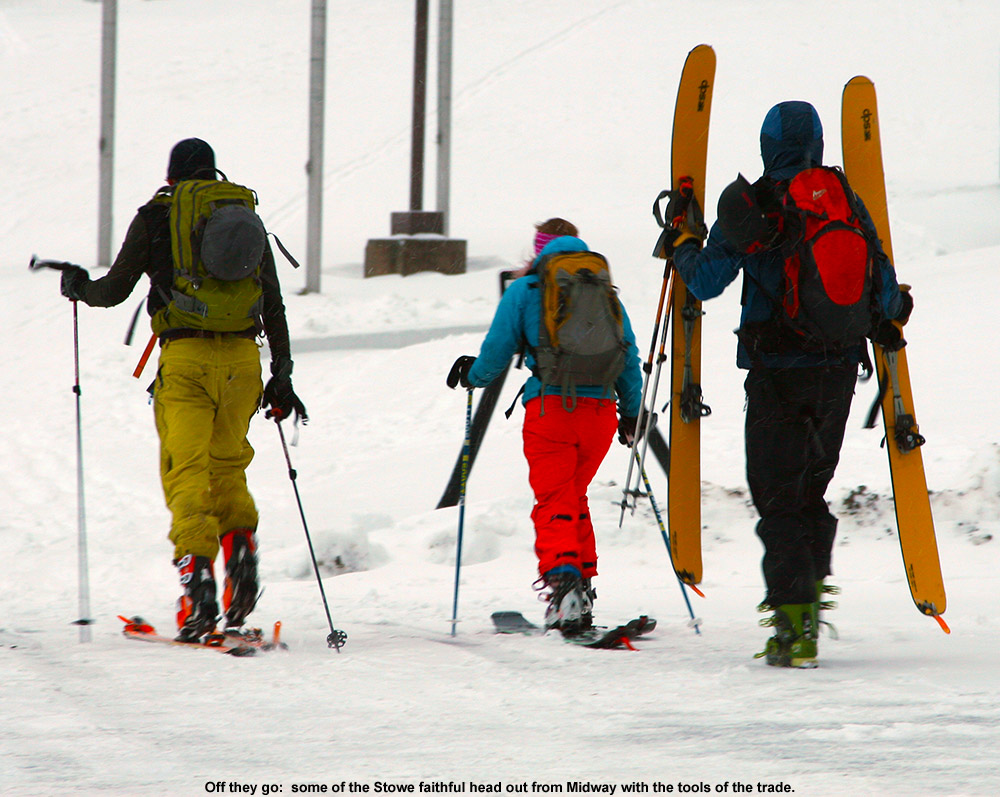
So I headed out to Stowe for another early morning session, and the temperature was definitely warmer this morning than what I encountered on Tuesday – it was even a bit above freezing in some of the mountain valleys, and around the freezing mark at the Midway Lot (~1,600’). The snow was still dry, but what was immediately evident was that the snow conditions aren’t as pristine now as they were a couple of days ago. The decrease in quality I saw was due to a combination of skier traffic and wind, and in those areas that were affected, the fresh fluff that fell yesterday was beaten down into something much denser. Since the snow had that wind crust in areas, it was a little harder to efficiently probe the snowpack depths on my ascent, but in general nothing has really melted over the past couple of days, and the snow depths with respect to elevation seemed fairly similar to the numbers provided in Tuesday’s report. I went with yet another ascent route today, and ascended the skin track up Midway that continued on to Liftline. This is the route that I had used last November, and it was a little frustrating at that point because I was using skins cut to Atomic RT-86s that were a bit too narrow for my AMPerages. I’ve got full-width skins now, so the issues from that day were resolved, but I was still slipping a bit up part of the Liftline skin track, and I’ve decided that it’s due to the fact that people have put in a skin track that’s just a little too steep. People should incorporate a few more switchbacks on the Liftline route to get a more reasonable grade on the ascent; it typically ends up being more efficient in the long run.
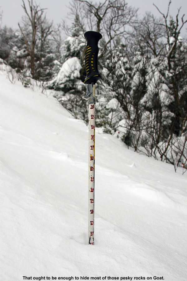 In any event, while I’d seen some decent, soft looking snow on Midway, Liftline was exposed and was riddled with wind crust. I watched a group of three guys descending the trail, and it was obvious from how little they were sinking into the snow that the wind crust was indeed substantial. One of the three appeared to be an excellent Telemark skier, and at one point he went head over heels dealing with the challenging snow. Seeing that spectacle, I decided to go for something more protected, and Goat came to mind. Some wind had still gotten in there, but it was far more protected than Liftline. I’m more leery about trails like Goat in the early season, since it holds a lot of interesting rocks, but as I probed along the skier’s left of the trail, I found a solid two feet of snow. That definitely looked sufficient for skiing the trail.
“The farther down
I went on the trail,
the more protected and
fluffier the snow was…”
With still a little trickiness to the snow, and the narrow, bumpy, rough and tumble nature of Goat, I found myself making plenty of alpine turns at first. I’ve got to say, I’d love to have another pair of these AMPerages mounted alpine, because they were a heck of a lot of fun in that snow – they created such a stable platform. The farther down I went on the trail, the more protected and fluffier the snow was, and I finished off with some beautifully soft turns on Lower National, which had seen a lot less traffic than the bottom of Lower Nosedive. Coverage remains quite good, and I even passed through some woods on my traverse to Lower National that could easily have been skied. That’s certainly consistent with the snow depth at the Mt. Mansfield stake hovering close to that 24” mark.
It was definitely warming up when I left, and I felt a little stickiness in the snow in the very lowest elevations (last couple hundred feet), so I’d say the snow down there will lose some of its fluffiness. There’s still plenty of snow out there for those that want to make turns, but you just have to pick the lesser used areas now if you want untracked snow. It also may mean going a bit higher to get into the winter snow, depending on how high the freezing line crept upwards today.
Stowe, VT 12NOV2013
It’s been a couple of weeks since those powder days back in October, and there hadn’t been much in the way of new snow, but over the past few days, early winter weather has returned and been the rule. A fairly small Alberta Clipper system came through the area over the weekend, and in typical Northern Greens style, Mt. Mansfield was able to turn it into a decent shot of early season white. As of yesterday, reports of 12-18” of new snow were already coming in, and it didn’t take long for photos of the powder to appear from Powderfreak. We soon saw pictures from the FIS crew and even from the National Weather Service, as one of their meteorologists got out to enjoy his forecast. The initial reports indicated that the snow had been reasonably dense, setting up a substantial covering of the slopes, and with another round of even colder, drier powder anticipated overnight with a frontal passage, it looked like Tuesday held the potential for some sweet, early season turns.
“If someone had asked
me about ski choice for
today, I would have just
said to take your fattest
skis, whether they’re
brand new or not.”
The front came through overnight as expected, dropping about an inch of snow down at our house, and more in the higher elevations. Things seemed to have come together, so I decided to head out to Stowe for an early ski tour. Temperatures were generally in the mid 20s F as I traveled through the mountain valleys, and there were no issues with the roads until I started climbing up toward the mountain around 1,000’. Above that elevation I found enough packed ice and snow that it warranted a bit more cautious driving. At the Midway Parking Lot (1,600’), the temperature was 20 F and there was light snow falling. There was the usual crowd of early morning skiers heading out and returning from the slopes, and I suspected it would be easy to find a nicely established skin track on any of the typical routes.
Since our last outings a couple of weeks ago focused on the Gondola side of Mansfield, I decided to mix it up this time and took the well established skin track that headed up Nosedive. It was well packed, and made all the sweeter by the fact that for much of the ascent there was a parallel boot pack available for anyone hiking without skins. The snowpack increased very quickly with elevation on the bottom half of the mountain, and I found the following depths during my ascent:
1,600’: 4-6”
2,000’: 8-10”
2,500’+: 12-18”
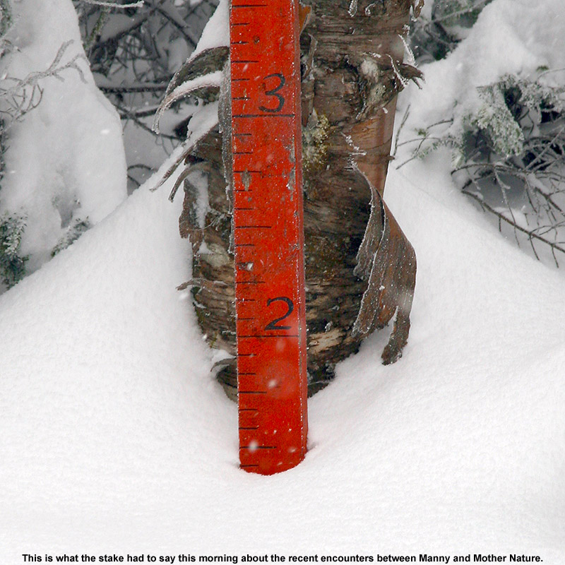 Above ~2,500’, I was essentially well into the deep stuff, and the gains in snow depth weren’t huge beyond that. Of course, when you’re already talking 12-18” of snow with plenty of substance to it, the lack of additional increases isn’t a big deal. At the top of Nosedive, I continued my ascent up the Toll Road for a few more minutes to check in on the depth of the snowpack at the fabled Mt. Mansfield Stake. At ~3,700’, the stake showed at least 17” of snow, and I generally found 18-19” there when I probed on the edge of the Toll Road itself, so indeed the snow depth up there was right around a foot and a half.
It’s really a nice sheltered area up along the road by the stake, and since the snow wasn’t perturbed by wind, you could definitely get a sense for where the snow stood with respect to quality. Indeed that quality was looking very good. As one would expect with the latest round of fluff, the snowpack was right side up with the lightest snow on top, and it was primed and ready for some turns. Big, dendritic flakes were falling while I was there switching over for the descent, and I stood and savored the moment for a while before pushing off down the road. I crossed over toward the Fourrunner Quad, and the summit area was awash in manmade snow. I didn’t even see that many guns going up there – I think the resort has already been able to hammer that area with manmade snow with the cold temperatures we’ve had.
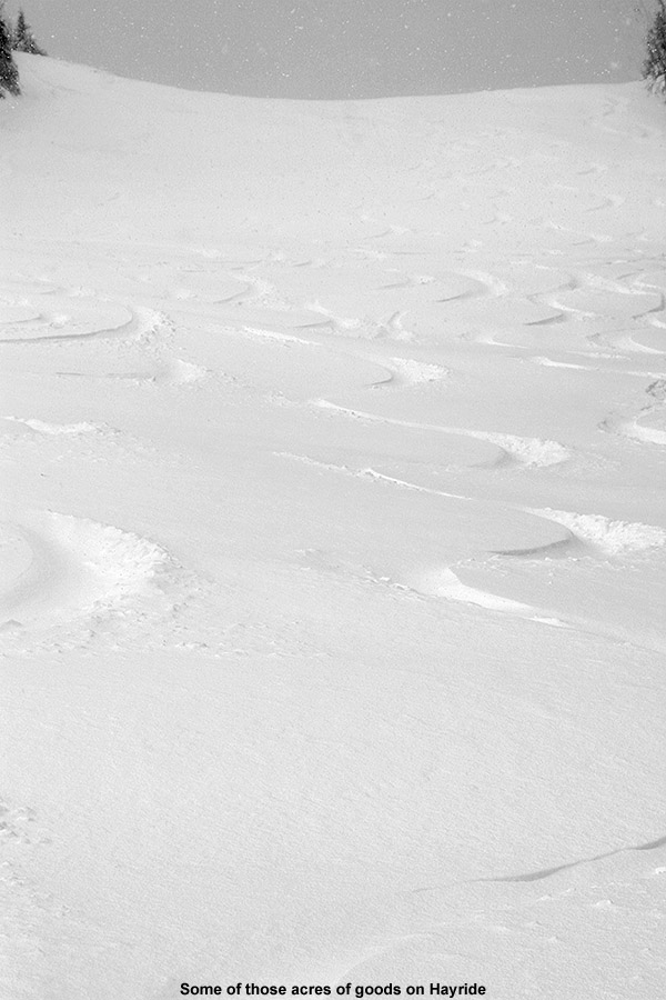
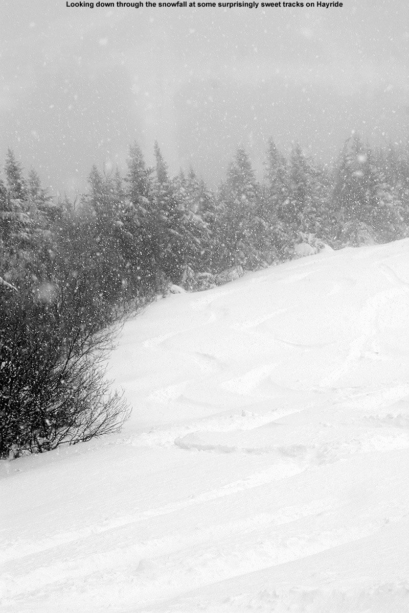
So now I’m left with just one more thing to discuss, the pièce de résistance for the day… the descent. While ascending Nosedive, it was clear that there had been a huge bolus of snow dropped above 2,500’, so coverage wasn’t going to be an issue. Temperatures were certainly not in question either, since it must have been somewhere in the teens F. That left the aspects of snow density and the effects of the wind, and based on the turns I was seeing by people descending Nosedive, it looked like the skiing was going to be fine, even if not sublime. But, I suspected I could do better. There had definitely been some wind on Nosedive that appeared to have packed out the snow a bit. With that in mind, I decided to roll the dice and check out another descent route – Hayride. I’d had good luck on Hayride back on April 10th of last year, when Mt. Mansfield got laced with over two feet of dense, resurfacing snow. It was actually the challenge of that snow on Telemark gear that was one of the final nails in the coffin in convincing me to finally get some fat, rockered skis for Telemark use. I could already tell that today’s snow conditions were nothing like what I encountered on that April outing – with the new fluff, this snow was notably drier. I hadn’t actually thought that it would be anywhere near the quality of what we had last November on the 30th, but after a few turns on Hayride I found that it was certainly in the same league. And indeed we’re talking quite the league – Hayride was sheltered from the wind, so turn after turn after turn I was able to push hard on the deep snow. It gave way, let you sink in, but pushed back with just enough force to keep you from getting to the ground. With 115 mm underfoot and judicious line choice, I think I touched down twice on something other than snow on the entire descent. Just like last November, the AMPerages were totally in their element, letting me play around in the deep snow on a remarkably stable platform. They helped out immensely with fore-aft balance, and I can recall some specific instances where I was saved from what easily could have been a face plant. If someone had asked me about ski choice for today, I would have just said to take your fattest skis, whether they’re brand new or not. Today, a combination of fat skis with the available snow would be plenty to keep you safely above most underlying obstacles. You’d probably end up having a heck of a lot of fun as well.


Stowe, VT 27OCT2013
Dylan and E didn’t get to head out to the slopes yesterday, but after what Ty and I experienced, it seemed like it was worth heading back to Stowe for more. We were hoping that the quality of the snow would hold up, but rising temperatures were a concern – by late morning at our house, lengthy periods of sunshine had already pushed the temperature into the upper 40s F. If Stowe was encountering similar conditions, the freezing line, and the availability of reasonably dry snow, was going to rise way up in elevation.
“…E was really putting
out some great turns on
her Teles. I was wishing
I could make Telemark
turns like hers today!”
Fortunately, Old Man Winter was still playing around just to the north. The sun that we were encountering in Waterbury quickly faded behind clouds and increasing precipitation as we headed north through Waterbury Center, and by the time we were passing through Moscow, the temperature had dropped to 40 F and we were under moderate rainfall. Warmer temperatures overnight had definitely melted out some of the lower elevation snows; whereas yesterday we found the first signs of snow around 900’, today they were up around 1,300’ near the Toll House slopes. Snow had melted back a bit at the Midway Lot as well, and we had to walk a couple hundred feet up toward Perry Merrill before we could put on our skins. Temperatures were still quite cool there at 1,600’, in fact, at 37 F it was a degree cooler than what Ty and I had encountered when we’d arrived yesterday. The precipitation had also changed over to light snow.
In order to let both boys go with their alpine skis as Ty had done yesterday, we gave them the Alpine Trekkers, and E and I used Telemark skis. We followed the same ascent route along Perry Merrill and Gondolier that Ty and I took yesterday. Once we got up around 2,500’, there was an excellent skin track along the climbers left of Gondolier, and it helped us make some good time. Dylan seemed to enjoy his ascent, getting his first chance to try out the Trekkers, and his first chance to try out his new Measurement Ski Pole. He was keeping up a great pace, and even as I was following along behind Ty at what seemed like a decent ascent speed, I was often surprised to look back and see Dylan right there nipping at my heels.
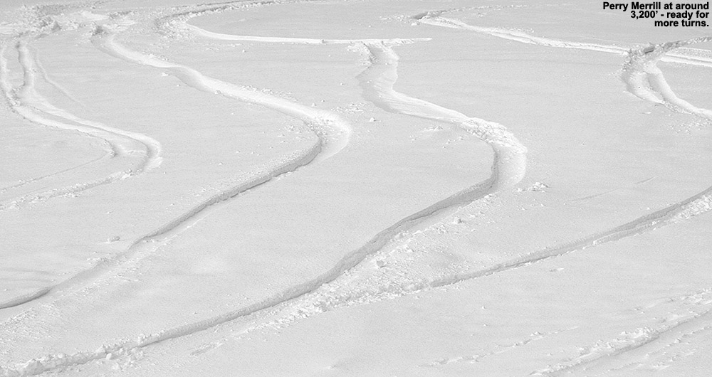
Although snow had definitely melted back somewhat in the lowest elevations, once we got up to around 2,000’, the snow depths actually seemed like they’d gained about an inch over what we’d found yesterday. We decided to stop our ascent at ~3,200’ on Perry Merrill based on what we saw for conditions above that and Dylan’s energy level, but we were well up into the dry snow by that point. Here are the typical snow depths that we found in the ascent, this time with three of us teaming up to contribute to the numbers:
1,600’: 0-2”
2,000’: 4-7”
2,500’: 7-9”
3,000’: 9-11”
3,200’: 11”+
As we took a break high on the mountain and got ready for the descent, we experienced notably different weather conditions than what Ty and I had dealt with yesterday. Gone was the pounding snowfall, we just had some clouds, and there were plenty of pockets of sunshine around. It was still below freezing up at that level however, so everyone made sure to quickly put on their extra layers before they chilled down after the hike. E got a call from Claire, who’d suspected that it was our car she’d seen at the base, and a conditions report was passed along.
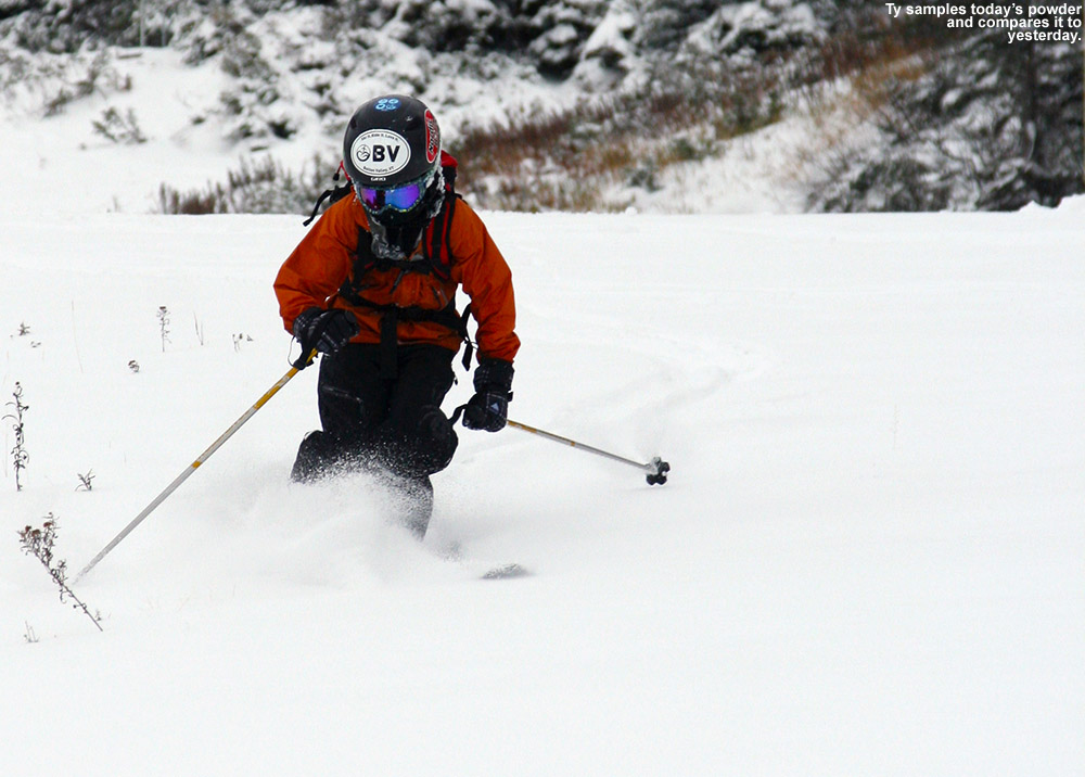
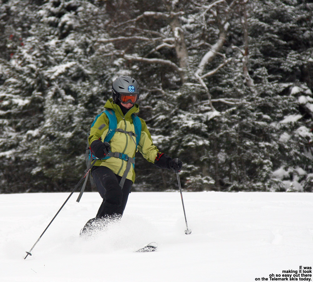
Once again, Perry Merrill looked good for the descent, so we took the route that Ty and I had used yesterday, especially since we had some good knowledge of the conditions. Ty really liked the conditions high up on the hill, while I think things were a step down from yesterday. The snow sort of transitioned from somewhat wind-affect, upside-down powder, to thicker, spring-like snow. I think that one less day of settling/weather affects, and the fresh snow that was falling, really helped to enhance things yesterday. We definitely got some good turns though, and there were plenty of fresh lines left to ski. I definitely had a more challenging descent that yesterday, switching from fat alpine skis to skinny Telemark skis, but E was really putting out some great turns on her Teles. I was wishing I could make Telemark turns like hers today! In later discussion, she was thinking that it might be all the extra support she’s getting from her new boots, and if that’s the case, they are definitely doing their job.
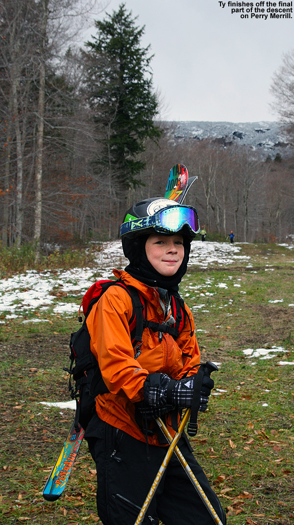 We decided to stop our ski descent at the 2,000’ mark, because the snow was just getting a little too thin for E and the boys to be continuing on their non-rock skis. It was a quick walk down back to the car into what was becoming a beautiful afternoon, and it was nothing like the maelstrom of wet snow that Ty and I had to deal with yesterday. Everyone felt like they’d gotten in a good workout, so a trip to The Whip was in order to finish off the evening. This October weekend has really marked a great start to the ski season, and we’re hoping there are more like it to come.
Stowe, VT 26OCT2013
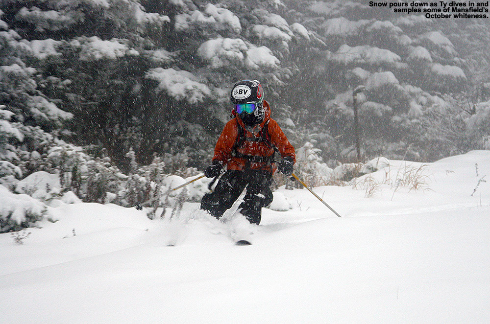
Well, we definitely got to witness Mt. Mansfield flexing the snowfall muscles today – despite the fact that we know this mountain’s ability to reel in snow, it just never gets old. Stowe delivers. I’d certainly been contemplating some turns, but after catching Powderfreak’s comment this morning about how it was dumping at the ski area, and then checking the web cams myself to see snow falling hard and fast at the base, that sealed the deal. Ty has been chomping at the bit for some skiing, so he joined me and we headed out in the early afternoon. Temperatures were in the low 40s F in the valleys, and the precipitation was generally light rain. The Worcester Range was visible to the east, white with new snow, but off to the west, a white haze hung over the spine of the Greens and we could see that it was definitely still snowing up there. The precipitation remained rain as we headed up the Mountain Road, but at ~900’ elevation near Northern Lights Lodge, we started to see leftover snow accumulations along the sides of the road. The snow on the ground continued to build, and by the time we pulled into Stowe’s Midway Lot at ~1,600’, we found 2-4” of snow on the ground up on the grassy slopes above. The temperature had only dropped to 38 F, but the precipitation had changed fully over to a light snow comprised of small flakes.
“…despite the fact that
we know this mountain’s
ability to reel in snow,
it just never gets old.”
We changed things up in terms of equipment today, and instead of Tele, we went with alpine gear using Alpine Trekkers for the ascent. I haven’t had the Trekkers out in a while, but it was time to bring them back into service; I’ve finally moved my old Volkl CMH Explosiv fat skis to rock ski status, and I was eager to try them out on one of these early days. My only Tele rock skis are my old skinny Rossignol Hellgates, and with a waist of just 70 mm, they’re really not a great tool for these early season powder days. Combining Tele + skinny + variable early season powder is certainly a recipe for challenge. Another reason to go with the Trekkers today was that Ty’s boots and bindings are now large enough to easily accommodate Trekkers. He’s not at the stage yet with his Tele skiing that he’s ripping up early season, potentially inconsistent powder with aplomb, so going alpine on the tour would be much more enjoyable for him. We decided to go with his carving skis instead of his powder skis for the setup, and fortunately we were able to get a good fit out of his skins from his Telemark skis.
 As usual, the Trekkers were great on the ascent. Although going with alpine skis and Trekkers is notably heavier than Tele, it’s typically not a big deal unless you’ve got huge tours to do. My biggest issue was with my skins – I’m not sure if the old skins for my CMH Explosivs have lost their water repellency, but whatever the case, today’s conditions had them catching and carrying a bunch of snow at times. I’d have Ty clean the underside of the skins off for me when we stopped, but we could never quite keep them from re-accumulating a coating of snow. Fortunately, Ty’s skins had no issues in that regard. The snow on the ground was quite wet at the base, but it dried out substantially as our elevation increased. We ascended via a bit of Perry Merrill, and then Gondolier to the Cliff House, and we observed the following snow depths with respect to elevation:
1,600’: 2-4”
2,000’: 4-6”
2,500’: 6-8”
3,000’: 8-10”
3,600’: 10-12”+
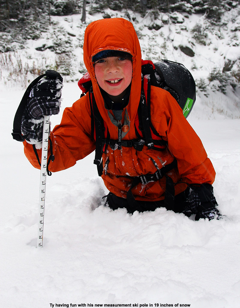
Aside from Ty’s first chance to try out Alpine Trekkers another new addition on this outing was his own Measurement Ski Pole. I put together measurement poles for both Ty and Dylan this fall, and it was great having Ty reporting depths along the ascent – with two observers we were able to collectively decide on the best approximations of depths to create the list shown above. It also kept Ty very interested in going higher, even if just to see how much deeper the snow was going to get. Although Dylan didn’t go out to the slopes today because he was off with E doing some shopping, based on Ty’s experience I think he’s going to have a lot of fun with the measurements on our next outing.
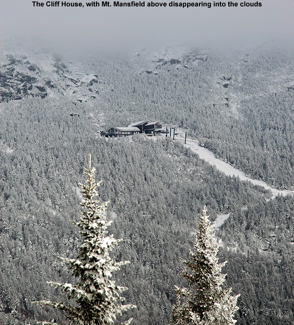
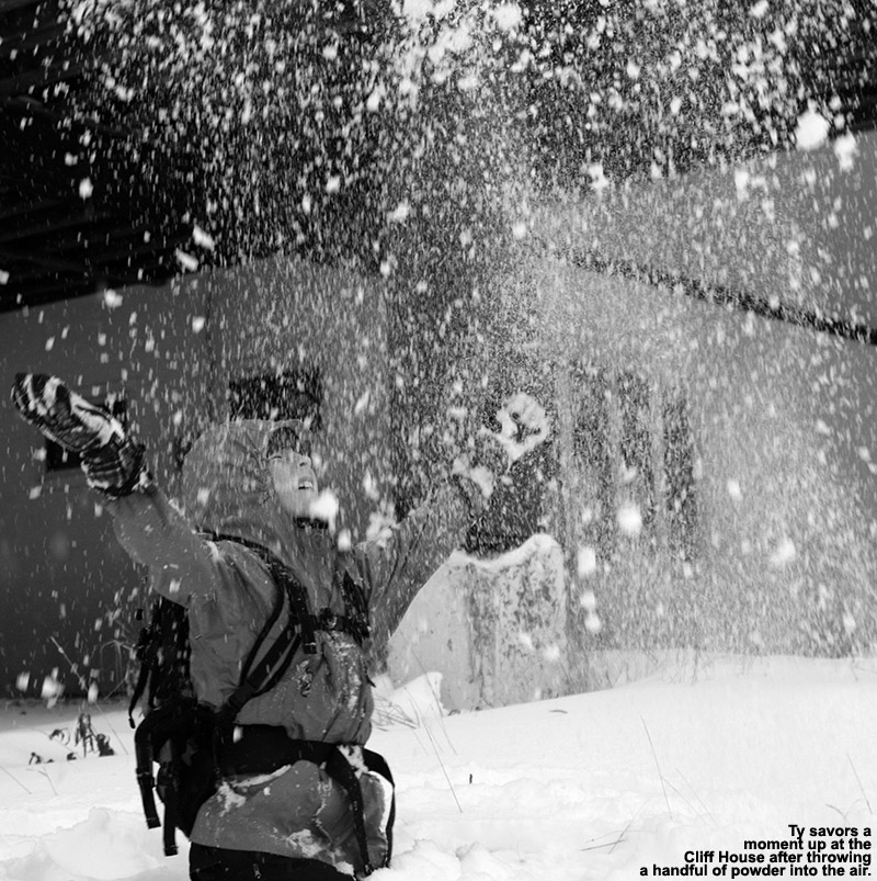
It was around 4:30 P.M. when we hit the top of the Gondola at ~3,600’, and the snow was coming down with some good intensity. It wasn’t quite inch an hour snowfall since the flakes were still fairly small, but it felt like it was somewhere between ½ and 1 inch/hr and it was quite impressive. We took shelter under the Cliff House to gear up for the descent because of the intensity of the snowfall, but there was almost no wind, so it was nice to hang out and watch the flakes pour down. With the late hour, thick clouds, and hefty snowfall, it had that dusky feel of December in the north. Ty and I discussed how it just as easily could have been December with all the snow. Another great milestone for Ty was the fact that this was his first full ascent to the Gondola, and it was nice to see that he still had plenty left in the tank at the top. We put a call in to Mom to let here know that we’d be descending soon, but also to let her know about Ty’s accomplishment.
We fueled up with some food and drink, but didn’t loiter too long because we knew the light was going, and we had to get in some shopping for dinner on the way home. Soon, we headed off down Perry Merrill, and one of the more challenging aspects wasn’t the snow, but the intense snowfall and reduced visibility. I’d been sort of soured on my CMH Explosivs the last time I’d used them, because they felt heavy and long and I just didn’t want to push them around, but today I’d say there was a newfound love for them. For whatever reason, perhaps because we were out on open trails instead of tight places, they felt great today – fat and stable, and just what one needs for the inconsistent early-season snow. Ty had to work hard on his skinnier skis to handle the powder, but we worked on technique on the way down and he made some great turns. I told him that if he could ski the powder on these skis, he’ll be cranking away when he’s on his powder skis.
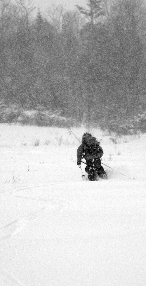 That more intense snowfall was with us on the entire descent, and the freezing line had gone down as well. Back at the car, heavy wet snow was falling, and the temperature was down to 35 F, three degrees below where it had been when we’d arrived. It was the sort of precipitation that soaked you very quickly once you were out of your Gore-Tex, and we both got pretty wet putting away the gear and switching out of clothing. The precipitation eventually changed back to rain as we dropped into the valleys on the drive home, but it was raining quite hard at times. There had already been some additional snow accumulations down to lower elevations by the time we were leaving, and the snow in some of the lower elevations actually looked better than it had on the way up due to some new covering. Overall the quality of the skiing was quite good, especially up high, and it could be even better tomorrow with more snow falling tonight.