At the end of our day at Stowe today, I found our Subaru covered in a deep coating of fresh snow that had accumulated during the afternoon.
Today was our first school program session of the season, so we were off at Stowe for the afternoon. With the level of skier traffic, especially weekend skier traffic that Stowe sees, Sunday afternoons don’t typically offer optimal snow surfaces. However, last season had to be a low point in that continuum; not only was the snowfall below average, but an inordinate number of times the next round of snow seemed to come in for Monday, after we were done skiing.
So far this season however, things have been much better. We had fresh snow for our training day back on Sunday, December 12th, and as we moved into our first session with the students, it looked like Mother Nature was going to try to help out with fresh snow again. On Friday, an inverted trough system had set up shop over New England, and while the focus was south of our area, we’d managed to pick up a couple more inches last night. This morning’s snowfall report from the house at 6:00 A.M. revealed that we’d already picked up almost a half foot of snow, and it’s easy to imagine what the skiing was like at Stowe today when the snow just kept pounding down – for all the details and pictures, head to today’s trip report from Stowe Mountain Resort.
E and I headed out to Stowe yesterday for the school program training session, wondering what we were going to experience in terms of weather. Happily, the first flakes appeared just after we arrived at around 8:00 A.M., the snowfall quickly ramped up in intensity, and then it dumped hard all morning and into the afternoon to make for great riding conditions.
Stan Biasini fills us in on how teach novice snowboarders at Stowe, Vermont.
This year we both decided to go with the snowboard training session, since out of necessity E seems to spend most of her time boarding instead of skiing, and it would supply me with some additional tools to serve as an alternate snowboarding coach when needed. We joined up with Stan Biasini’s group, since he would be advising everyone on how to work with the students that were early in their snowboard progression. We started out with techniques for the “never evers” at the Magic Carpet, then stepped it up to Inspiration, followed by the Alpine Double, and finally the Sunny Spruce Quad. We got a raft of good teaching techniques, and Stan made ample time to ensure that everyone got plenty of their own instruction as well. I learned that Stowe no longer requires leashes for snowboards, and that the slope of the Inspiration trail is an impressively consistent 8% grade for teaching. Continue reading the text and see all the pictures by going to the full trip report from Stowe today.
Dylan works hard to keep pace with Ty as we skin up Spruce Peak.
By this morning, enough snow had accumulated that we decided to head up to the higher elevations and check it out. Without much of a base, we didn’t expect the skiing to be too great, but it would be a good chance for Dylan to get on his skins and see how everything was working for him.
We first stopped in up at Bolton Valley, where accumulations appeared to be in the 2-3 inch range at the main base (~2,100’). I took a look around to see if any manmade snow had been put down outside the areas of current snowmaking operations, but didn’t see any on the lower mountain. A good amount of snow had been made in the Mighty Mite learning area, a fan gun was blowing snow above the lodge, and I could see at least one other gun going underneath the Mid Mountain Chair. The snow was certainly light and dry, and the powder had accumulated up to a foot in some areas. We hung out for a bit and let the boys play in the snow, then we headed off to Stowe to see if any ski options were available atop manmade base snow at Spruce Peak.
As we drove toward Stowe, we could see that the valley snow accumulations were quite variable. We had an inch or two at our house on the Waterbury/Bolton line, and there was a bit less in the center of Waterbury. North of Colbyville however, the ground was bare, and between there and the Stowe’s Lower Village, there was only the occasional dusting visible on the ground. As Powderfreak had mentioned in one of his reports to Americanwx.com, we saw a sharp increase in snowfall amounts as one entered the center of Stowe, where they had picked up a fluffy few inches earlier in the morning.
Up at the mountain base, accumulations were similar to what we’d seen at Bolton, with roughly 2 to 3 inches on the ground at the Mt. Mansfield Ski Club building. We were surprised to see that lift-served skiing was going on over at Spruce (Easy Street area), so we decided to skin up above that elevation and check out the options. We headed up toward the Sunny Spruce Quad, and found about 4 to 5 inches of fluff as we approached the top of East Run. The snow was definitely fluffy, so good turns could be had on grassy slopes, but beyond that it was sketchy. It was definitely rock ski/junkboard territory, although with all of the extra snow we’ve had in the past couple of days, that will be changing. To continue with the rest of the text and see all the pictures, click through to the Stowe trip report from today.
Ty skiing some October snow on Perry Merrill at Stowe Mountain Resort
Even before the storm existed, the formation of the season’s first Nor’easter had appeared likely for several days, and with it, the appearance of at least a few flakes in the higher elevations of the Northeast seemed like a good bet. However, the question of the whether or not we’d see our first decent dump of skiable snow took a few more days to settle out. Eventually, the mountain forecasts came into focus, and it looked like the Greens were going to get good elevation snows up and down the spine. The Northern Greens seemed to be in a good spot for precipitation, but the Central and Southern Greens were likely to be closest to the core of cold air that would support the most early season snow. On Wednesday the 13th, Scott Braaten did a nice job of alerting everyone about the setup through SkiVT-L and Lionel Hutz was all over it at the FIS website.
On Friday, October 15th, the storm was underway, and morning reports were already coming in about snow falling in the Southern and Central Greens. The pictures from the Killington web cam were looking quite wintry even at the lower elevations, and when Paul Terwilliger sent in his Friday Killington trip report to SkiVT-L and said he’d already found 18 inches at the summit, it was clear that the area was getting a good shot of snow. By that point the temperatures indicated that the Northern Greens were getting plenty of snow as well, but if they weren’t going to catch up to the Killington area, I was thinking that it might be a good time to mix things up and head a bit south for turns.
My thoughts of heading south to Killington were suppressed somewhat around 8:30 P.M. that evening. After checking on our rain gauge a couple of hours earlier, I hadn’t looked outside at all, as a massive sword and ball battle had kept me busy in the basement with the boys. When I finally did look out back, I was very surprised to see that it was snowing… all the way down at our elevation of roughly 500 feet. The air temperature had dropped to 33.3 F and the precipitation was big flakes of snow, without even any rain mixed in. The snowfall lasted for a couple of hours, long enough to put down 0.3 inches of slushy accumulation on the snowboard and coat the ground white. Eventually as the precipitation slowed down, the temperature began to warm up and it all changed back over to rain. I knew that if we were getting snow all the way down to the lower valleys though, then the local mountains must have been getting pounded, so I suspected that Mt. Mansfield would come through with sufficient snow to make it worth skiing.
The next morning we had steady rain at the house, and valley temperatures in the low 40s F as Ty and I headed off to Stowe. The snow level had clearly risen up overnight, as we didn’t see any signs of snow at all until the slopes of Spruce Peak came into view. We headed to the base of the Gondola (~1,600’) which seemed to have the best accumulations of snow at low elevations. The temperature was in the upper 30 s F, and there was a gusty wind in the parking lot. Although a little thin, coverage was still enough that one could start skinning from the lot if they wanted, but we decided to hike for a bit to get some variety in the ascent. Snow depth at the bottom of Perry Merrill was 2-3 inches, but with the warming temperatures any disruptions in the snow were seeding its melting. The footprints of earlier hikers were already holes in the snow with colorful foliage showing through. To continue with the full text and all of the pictures, click through to the full trip report from today at Stowe.
Looking down Stowe's Hayride ski trail at the fresh October snow and brilliant fall foliage
For quite a while, the local weather gurus had been talking about the potential for local snow at the end of September/beginning of October. Yesterday, reports started coming in of white in the mountains, and from UVM I could see the tendrils of snowfall crashing out along the Green Mountain spine. It was looking like this morning would feature some real accumulations of snow, but yesterday evening the snowfall seemed to come to a halt. I started to reconsider my thoughts of taking a morning trip up to Mt. Mansfield, but sometime after dark I checked the local radar and it looked like snowfall was blooming again. I awoke this morning to see that there were still echoes on the radar, the temperature at the house was ~41 F, and our back deck was wet. I suspected there had been some additional snow on Mansfield, so I hopped in the car and decided that I’d at least go for a hike before work.
While I couldn’t see much white at all on my drive to the mountain, as I finally got close to Mt. Mansfield, I could see that there was a good covering of snow from about the middle elevations of Spruce Peak on up. I parked in the upper lot of the gondola (~1,600’) and there were a half dozen cars that looked like they could belong to other early morning folks checking out the snow. Snow was falling all around me, and while it wasn’t sticking at the base, I could see white on the ground not far above. At some point after 7:30 A.M., I strapped my skis on my pack and headed up Nosedive, hitting the snow line right around 1,800’. The depth of the snow didn’t increase too quickly, only up to maybe ½ to 1 inch in depth by the 2,000’ mark. I thought that the snow would probably be great for the junkboarders, but I wasn’t quite sure about those who were on regular skis. Not long after I had that thought though, I met three skiers coming down Nosedive, right around the intersection with National. They clearly seemed to be making due on regular skis and seemed to be enjoying it. During my ascent it snowed most of the time, and occasionally the snow came down with moderate to heavy intensity. Being starved for a bit of winter weather, I loved it.
Even by the top of Nosedive (~3,600’) the snow was only up to about 3 inches in depth, but I hiked on a bit farther to check out the Mt. Mansfield Stake. There was some vegetation in front of the stake (~3,700’) that hadn’t let the snow settle all the way to the ground, but the depth of the snow was clearly less than 6 inches. At least one vehicle had driven on the Toll Road, but I still popped on my old Telemark skis and did a little gliding in the untouched snow outside the tire tracks. That was quite pleasant, although due to the minimal snowfall, there was the occasional crunch of a piece of gravel. Not wanting to deal with the hassle of negotiating the steep terrain of Nosedive with somewhat minimal snow, I continued on the Toll Road and into the Ridge View area before deciding to take off my skis. I had even made a few Tele turns on the snowy grass, but by around the 3,000’ elevation, a combination of wanting to head back in the direction of the Gondola via steeper terrain, and not wanting to put any real damage into my skis saw me strapping them back on my pack. I’m not totally ready to commit the Hellgates to official rock ski status just yet.
Hiking up had been really enjoyable (I think it was the first time I’d hiked such a long distance in Tele boots without switching to skinning) but the vistas on the descent were spectacular. With the dramatic scenes of white surrounding me, and the brilliant colors in the valley, I stopped frequently to pull out the camera. My descent was somewhat meandering, taking me down through the Hayride and Lookout areas, before making it down to Crossover and down to the gondola lot. The snow level on Mansfield looked like it had crept up a few hundred feet since my ascent, so it was certainly warming up. Insofar as I can recall, I think today’s outing was the first time that things came together to allow me to ski on my birthday, so that made it even more of a treat that usual. To check out all the pictures from the day, head to the Stowe trip report from today.
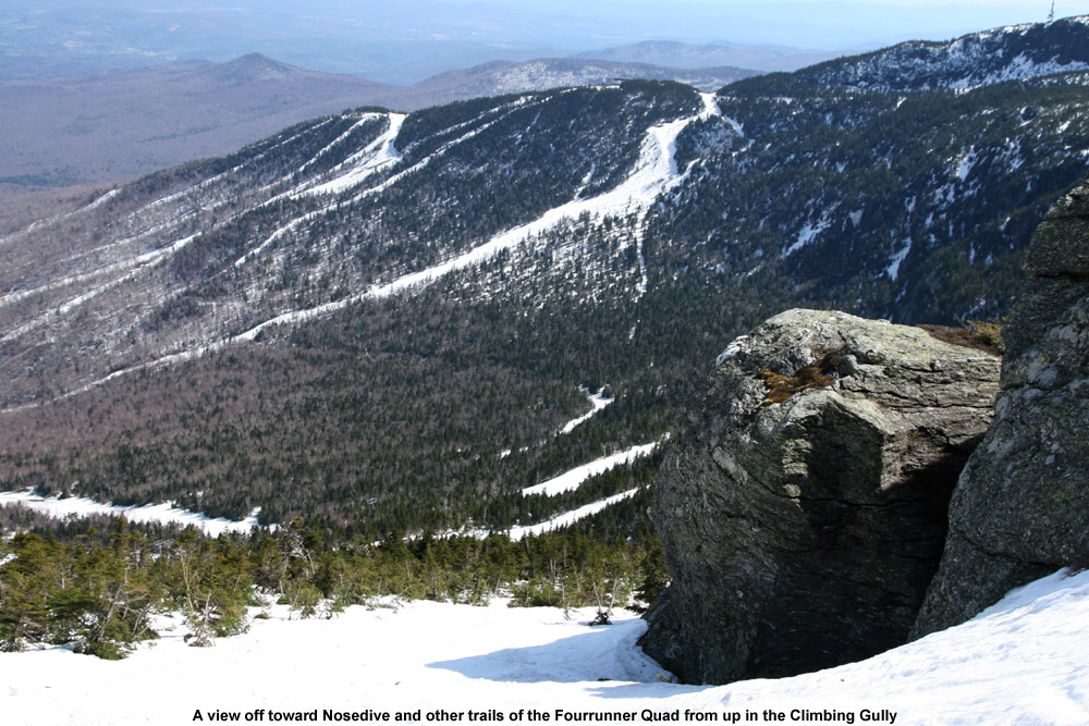
Looking back at the resort trails today as I head up into the alpine
The boys were more interested in planting flowers with Mom on Saturday than skiing, so unfortunately I couldn’t interest them in going out for some turns. This meant that I was on a solo outing, but the upside was that I’d be able to do a much bigger tour than I would have been able to with Ty, or especially with Dylan. The skies were clear and blue all Saturday morning on what was likely our warmest day of the spring up to that point. The temperature was already around 80 F when I pulled into Stowe’s Midway lot (~1,700’) in the early afternoon, and with the forecast for temperatures in that range, I hadn’t been too optimistic about the snow quality. My major goal was to at least get in a good workout, so I was willing to negotiate some sloppy snow on the descent if that was the way it had to be.
Snow was available right from the Midway Lodge elevation, with just a couple hundred feet of fairly flat walking on grass to get on it from the parking lot. I was immediately surprised when I got on the snow and found that it wasn’t sloppy at all; it was all corn with just the top inch or so loosened up. That’s the sort of corn that seems to provide some of the easiest turns, so I was immediately enthusiastic about the potential for a quality descent. There wasn’t much of a breeze in the lower elevations, but the snow helped keep the air temperature a bit cooler and the ascent was very enjoyable. For ascent attire I’d gone about as minimally as I felt comfortable doing, with a short sleeve polypropylene T-shirt and my ski pants with the side zippers fully open, and that worked out to be a comfortable setup for the temperature. I hadn’t made a non-powder ascent on skins in a while, and I was quickly reminded how the lightness of Telemark gear allows you to simply fly up the slopes. Before I knew it I was up at the Cliff House (3,625’) and feeling great, so I decided to keep going up into the alpine.
I set my skis onto my pack and hit the climbing gully. There was a bit of rotten snow in spots, and as I didn’t immediately find a boot ladder, I had visions of an inefficient, sloppy climb with lots of post-holing. I’d already post-holed a few times in the outskirts of the gully (it only took one of those to remind me to get my ski pants zipped up at least halfway) but fortunately, about 50 feet up the climbing gully I found a boot ladder made by some nice big feet. That made the going fairly smooth, and the views of the Green and White Mountains continued to improve with each step. Near the top of the gully, I ran into a guy about to descend. He had spent an overnight or two on the mountain, and said that he’d been amazed to find fresh powder on Friday morning when he’d started skiing. It sounds like along with Thursday morning, Friday morning had also been good in the higher elevations with regard to fresh snow. The downside of the fresh snow was that conditions in the alpine were still a bit sloppy. The new snow had not yet cycled to corn in the highest elevations, so it just wasn’t going to provide an optimal surface. By the time I departed from my conversation in the gully, I was moments from the Mansfield ridge line. Up on the ridge I enjoyed the new westerly views of the Champlain Valley and Adirondacks, and decided to stop in at the top of The Chin (4,395’) since I was so close. There was a small group of college students enjoying the popular leeward side of the summit, and there was a pleasant breeze of probably 15 MPH or so. The high temperature for the day at the Mt. Mansfield Stake came in at 67 F, so I suspect that the summit maximum temperature was probably close to that. Getting an April day like that at the top of The Chin is certainly a treat.
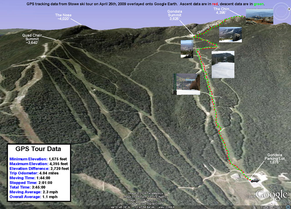
For my descent, I wasn’t able to ski right in the summit or the West Chin area due to lack of snow, but I was able to ski down the gully where the Long Trail drops away from The Chin as it heads south. It was quite a perspective to see the snow create a flat surface through the gully, when in the off season it’s a 10-foot deep chasm containing the hiking trail. I had to remove my skis to descend the very top of the climbing gully, but below that point one could keep them on continuously. As expected, the new snow up high that hadn’t fully cycled to corn wasn’t as nice as the corn snow on the bottom 2,000’, but I actually had some fun turns in the climbing gully, and it let me work on Telemark turns in steeper, tighter confines. I still had to make some alpine turns and throw in some side slipping up there since some areas were just so tight, but overall the gully allowed a good mix of styles. The crème de la crème of snow surfaces for the day was probably the top half of the Gondolier descent. There must have been very little traffic up there because most of the snow surface was just a smooth layer of ripe corn. The lower half of Gondolier still had nice corn snow, but the surface wasn’t as smooth as the top half of trail. Perhaps the lower elevations had experienced more melting that started forming aberrations in the surface. Based on my GPS data, it looks like my descent was 2,720’, not quite what you can get for vertical in the winter when you head all the way back down to Route 108, but still a decent run. There were still about 7 feet of snow at the stake on Saturday, and even though that level has dropped some with the recent warmth we’ve had, skiing should available on Mt. Mansfield for a while.
A Google Earth/GPS map of today’s ski tour up to the Chin of Mt. Mansfield – Click the image for a full size map
My route on Mt. Mansfield today took me up toward the Sunrise trail to enjoy some early October powder.
Today I went up to Mt. Mansfield to get some turns in the snow before it started to disappear. A nice cold snap has dropped over a foot of new snow on some of the mountains, with snowfall reaching even down to Burlington. Traveling on I-89, I first saw snow on the Robbins Mountain Power Line, up around 2,000′. It was very patchy and hardly noticeable, so I was worried about how the lower elevations would be on Mt. Mansfield. Things looked up as I entered Waterbury (~520′) and found traces of snow on the ground. At the base of Mt. Mansfield (~1,600′) there was an inch or two of snow on the grassy surfaces. I hiked up in the region of the triple, looking for slopes that had nicely mowed grass for the trip down – a map of my route is pictured along with this text. At around 2,500′, the snow was over 6 inches deep so I threw on my snowshoes to make the going easier. I stopped my hike at around 2,920′ (see map) since it was time to head to work, but the snow depth had increased to about 8-10 inches. The snow was fairly heavy (~11% H2O or so), but light enough to make powder turns. I’m sure it was even better up at 4,000′ and above. The first half of the run had the best snow, with much stickier stuff lower down, but I was still able to ski right back to the base of the triple and make a quick departure for Burlington.
Well, the weather setup leading into this weekend was a 4 to 6 inch snowfall yesterday; so it came just in time for weekend turns. Somehow, there came to be a bit of a crust on top, but unlike last weekend, it was paper thin and didn’t really affect the non-groomed terrain.
Today I caught up with Shawshank at Stowe sometime between 7:30 and 8:00 A.M. and we hit the usual stashes with other folks that we knew. The big event came in the afternoon with a 1:00 P.M. meeting at the top of the Gondi and a hike into the swirling mists of The Chin. Let’s just say, without the guidance of Shawshank, there would have been no way to find anything up there in the near zero visibility. The wind was probably gusting to 40 mph at times, but it wasn’t bad for the top of a mountain, and by the time we reached the Hourglass Chute, we were protected altogether. Hourglass was fun, although it seemed to be over so quickly. I remember reaching this one point about as wide as the length of my skis (the narrow part of the hourglass) and four turns later we had to bang a left to make the connection to Hell Brook. We traversed for about 50 feet, took a quick step up a short incline, then dropped a nice little section into the low point between the Adam’s Apple And The Chin (so I was told; still socked in). After a bit more of a traverse, we found ourselves at the top of Hell Brook. I thought that it was going to be a singletrack adventure down into the Notch; I was definitely wrong there. As it turns out (at least at this time of year) it is much like an interconnected patchwork of trails, snowfields, and gullies which gradually narrows into a single gully towards the end. Actually, a lot of it reminded me of the gullies at Alta or Snowbird, except that it was a lot longer and there were hardwoods about. One could take this thing 20 times and still not know the whole maze; it makes for some very fun exploration. A word of caution: there were numerous spots where a wrong turn would mean a big drop or other hazards that could ruin your run so take it easy. Shawshank lost his goggles in a little open water spot and before anyone knew what was up, they were down the brook and under the snow. Damn. We finally wound up on Route 108 for a mostly (one bit of uphill) downhill traverse back to the Gondola and nearly 3000′ of vertical in one run. By the time we got back to the quad it was about 3:30 P.M. and we were kaput.
I stopped in at the Stowehof where my friend Chris was staying. It’s a real quaint place with great views. I think that the bar and restaurant are open to the public, but just walking around in there is a lot of fun.
Shawshank tells me that the lifts at Stowe will start running at an incredible 7:00 A.M for Sunday. OK, I’ll be there bright and early. Recording a possible record arrival, I get myself to the quad before 7:30 and find it humming right along with people returning from runs. After a warm-up attempt to get some freshies on Liftline/National, I ran into Andor & co. right in line. The rest of the morning consisted of Goat, Queebs, traverse, learn, Chin Clip, Goat?, Starr, Starr or something like that. I found myself happily buried more than once. At lunch we met up with Shawshank, ate some food and went back at it. Shawshank reported a multitude of freshies on hayride earlier in the day, so awaaaaaaaaaay we go. In my head and body I’m thinkin’ “Gawd I’m tired, a couple more runs should do it for me, I mean 7 something A.M was a long time ago.” Whoops look what we found, more fresh woods. Any thoughts of leaving were gone as we plowed our way through virtually untracked freshies on “Oh Shit”, “Major Jones”, and others. By connecting everything right, we had found top to bottom fresh woods off the quad “Who could leave?” The stake near “Oh shit” read 3 feet, 6 inches of snow and I whole heartedly believe it. When it finally became too dangerous to ski anymore, we called it. Through the magic of powder, I had managed to reel in over 30,000 vertical without ever realizing it. Now that’s a drug.
OK, back to reality. There was a harsh wind blowing up top, 0 degrees air temp + wind = -38 degree w.c. The wind was also blowing some of the snow off the trails and exposing the ice underneath (more reason to stay off-trail). Lines were a bit long in the noonish hours, even the gondola had a line. I don’t know about the big streambed, but a lot of little ones are still visibly flowing, maybe from all the insulating snow. More poachers getting nabbed on lower lift line, Lookout wasn’t open (100%?) and the Tollhouse lift wasn’t running.
(A friend of mine ended up there on his first day of snowboarding, apparently crossing no ropes, and had to get a ride back. The guy who gave him the ride said “Yeah, that’s been happening a lot today” ?What’s up with that?)
But I’m certainly not complaining.
Next weekend I’m skiing in NH “yikes” and I’ll send in one of those “out of state” reports
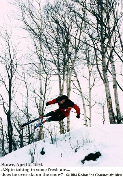
Catching some air today at Stowe while Rolandos runs the camera
Today I spent the day skiing with Rolandos and Chris at Stowe – we had soft spring snow and hit some of the old favorites like Lord, and of course Hayride with those great bumps. Rolandos took some photographs with his camera, and it was great having the chance to be out with a skilled photographer possessing a real SLR camera. Rolandos scanned his negatives (or something along those lines) and created some digital images that I’ve added to this report.


