

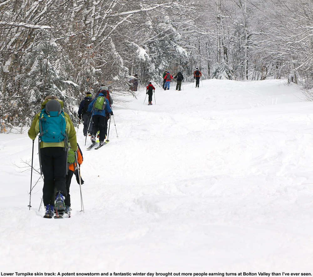
The Vermont ski season is definitely underway! As forecast, the snow levels with this most recent storm began to drop yesterday evening, and the higher elevations picked up some decent snow accumulations by morning. The views from Bolton’s Base Lodge Webcam seemed to suggest just an inch or two of accumulation at 2,000’, and unfortunately their Vista Summit Webcam was covered in snow, but the Allyn’s Lodge Snow Stake Webcam at Sugarbush suggested that there were some decent accumulations around 3,000’. So, I decided to head up to Bolton Valley to at least get in a hike in the snow and check out the actual accumulations in person. The snow levels with this storm definitely didn’t make it down to the lower valleys, and even the local 2,000’ peaks surrounding the Winooski Valley in our area didn’t seem to have any visible accumulations.

Those observations left me wondering just how high the snow levels had been, but it was clear as I ascended the Bolton Valley Access Road that the spine of the Greens had done better than some of the other surrounding areas. On my ascent toward Bolton Valley, I saw the first traces of snow around 1,200’, and up at the main base at 2,000’, accumulations were definitely more substantial than what the base area webcam had suggested. There was plenty of wind with this storm, and while exposed areas may have only accumulated an inch or two of snow, areas out of the wind held 3 to 4 inches of dense coverage.

I started hiking the Wilderness Uphill Route with my skis on my pack, but within a couple of minutes I pulled out my skins and started skinning. It was clear that there was more than enough coverage to be skinning instead of walking if you wanted to, and there was a skin track in place as well. Snow accumulations increased all the way up to near the 3,000’ elevation range, but much like what the Sugarbush webcams had shown, where the 3,125’ stake had 5 inches of snow and the 3,900’ stake showed less than an inch of snow, accumulations sort of fell off as you hit the ridgelines above 3,000’. It must have been those winds – they really pounded and scoured the upper elevations relative to those middle elevations.
Here’s the snow accumulations profile I observed today in the Bolton Valley area during my tour in the midday period:
1,000’: 0”
1,200: T”
1,500’: T-1”
2,000’: 1-4”
2,500’: 4-6”
3,000’: 7-11”
 The forecast today suggested that at above 2,000’ the temperature was never going to go above freezing, and I’d say that’s what I observed. The temperature at 2,000’ was right around freezing and the snow there was a bit denser and softer, then in the middle elevations it was denser and colder with some upside-down consistency, and them up around 3,000’ the temperatures were well below freezing and the snow was notably drier. The snow was still a bit on the denser side, but it didn’t have that upside-down feeling of the middle elevations and turns were easier.
When I finished my ski tour and got back to my car, I saw that I’d missed a call from Dylan, so I called him back and he said that he and his crew from UVM were just at the base of the access road on their way up. So, I hung out for a bit, met them when they arrived at the base, and gave them the beta on everything I’d found on my tour. They subsequently had quite a fun tour of their own based on the video footage I saw later when they swung by the house, so it was great to see that everyone had a safe outing, and they kicked off their ski season with style!


