Getting out to Bolton Valley for a quick morning tour on the snow from Winter Storm Caly delivered some excellent turns.
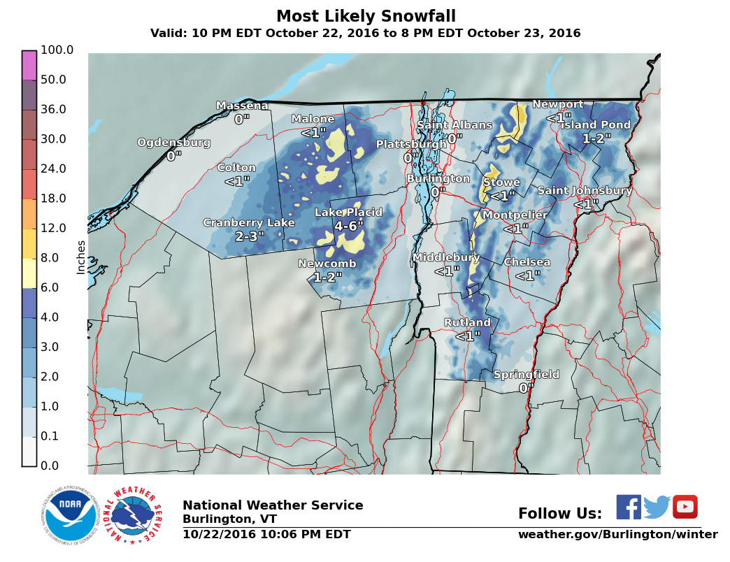
Yesterday evening at some point after 9:30 P.M., light snow began falling at our house in Waterbury with the approach of Winter Storm Caly. Winter Weather Advisories were put in place for a fairly moderate 3 to 6-inch snowfall, which was expected to fall overnight and into the Monday morning commute.
This morning for my 6:00 A.M. CoCoRaHS observations at the house I found 3.3 inches of snow on my snow measurement boards. Snow was still falling in the form of small (1-2 mm diameter) flakes, and based on the density of the snow in the accumulation stack it appeared as though that smallish flakes had been the general trend throughout the storm up to that point. My liquid analysis revealed that the snow was right around 10% water content, so it’s certainly not Champlain Powder™, it’s very much your typical synoptic snow. This standard, medium-density snow is great in terms of building up the snowpack, which is important this time of year.
“…the turns could really flow, and they did.”
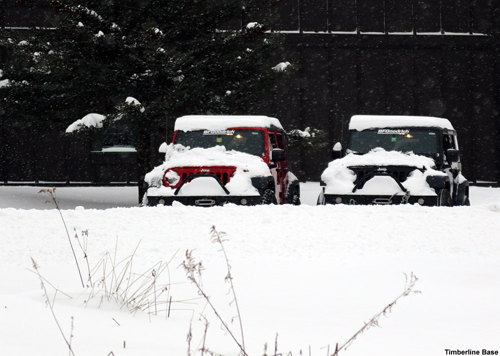
School was cancelled for E and the boys, not so much due to massive amount of snow falling, but presumably the timing right during the morning commute. I wished them a good snow day, and headed off to stop in at Bolton Valley on my way into Burlington. Bolton’s Timberline area had looked just a touch lean on base when I check on my way to the resort on Saturday, but I figured with this latest round of dense snow it was time to check it out. At the Timberline Base I’d say there was a similar amount of accumulation to what we picked up at the house – roughly 3 to 4 inches.
Making use of the great skin track on Twice as Nice today
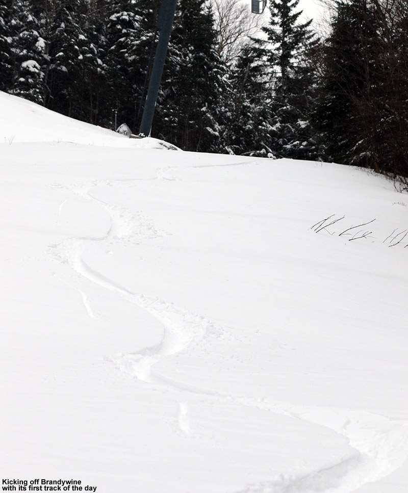
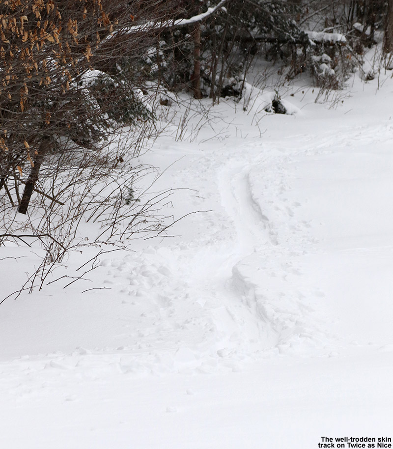
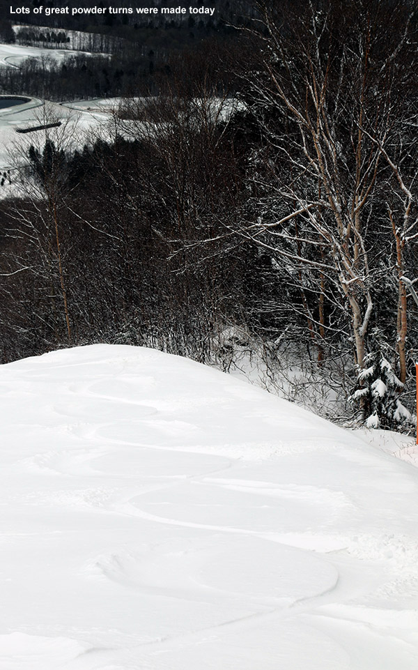
The skin Track on Twice as Nice was in excellent shape, so I made good time up to the Timberline Mid Station, where I decided to mix things up a bit from recent outings and head a little father to ski Brandywine. This turned out to be a great option, since it hadn’t seen any skier traffic and I got to enjoy first tracks. While this new snow is fairly medium density, it actually skis quite well where no wind has affected it, and Brandywine certainly delivered there. Although this certainly wasn’t out lightest powder of the season, today’s outing featured some of my favorite turns up to this point because the snow was consistent, there was plenty of base, and of course the untracked nature of the trail meant that I could get first tracks on whatever line I wanted. That meant that the turns could really flow, and they did.
It sounds like we’ve got light snows in the forecast this week, with the potential for a larger system toward the weekend.
Over the past couple of days, a storm has dropped over 20 inches of dense snow on Mt. Mansfield and Stowe Mountain Resort. This storm is both building base and delivering plenty of powder.
There really wasn’t much lead up discussion on the American Weather Forum about the winter storm we’ve been having in the Northern Greens the past couple of days. That’s because, while it looked like the mountains would muster up some snow accumulation, the models hadn’t really suggested that we’d be getting TWO FEET of accumulation. But, once the snow levels dropped into the mountains, Mother Nature just continued to drive that moisture into the spine of the Greens, and it kept snowing. It’s been snowing continuously now for two straight days.
Snow filled the air down to the lowest mountain valleys today.
Temperatures were a degree or two above the freezing mark around in the lower mountain valleys at mid-morning when I was heading out today, and the precipitation was all snow, but accumulations were quite variable with the borderline freezing temperatures. We had about an inch on the ground here at the house on the Waterbury/Bolton line, and that tapered off to much more patchy accumulations in Waterbury and Waterbury Center. The accumulations picked back up again once I was into the Stowe Village area, fairly similar to what we had at the house. At The Matterhorn around the 1,000’ mark I’d say the snow depth was roughly 2 inches.
“…and then there was that snow. There’s so… much… snow. Oh man, talk about a thorough resurfacing.”
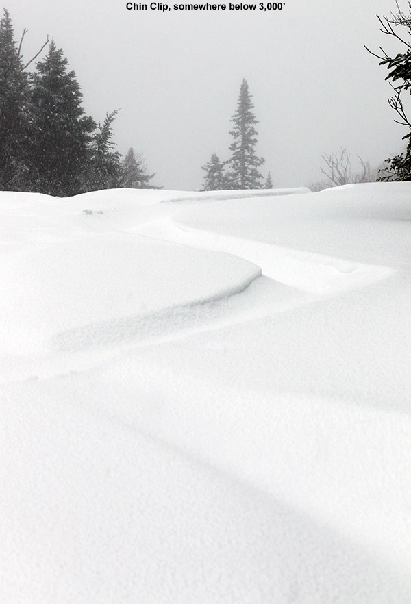
Just making that jump up to ~1,500’ at the base of the resort resulted in a huge increase in accumulations. My depth checks revealed ~10” of new snow at the base of the Gondola, and that measurement was fairly easy, since the old base had generally melted out down at that elevation. I skinned up Chin Clip Runout, since I like the grade, seclusion, and protection from any wind more than heading right up Gondolier. Actually though, winds today were pretty minimal in the lower mountain elevations, and with the temperature just a bit below freezing, it was really pleasant.
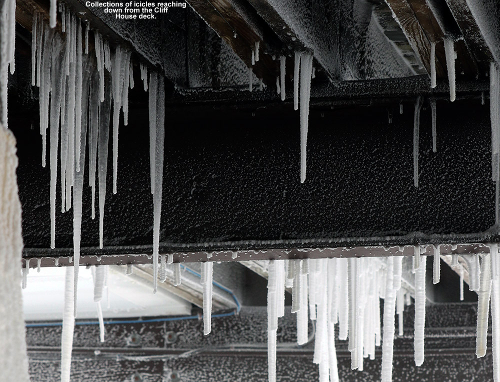
Above mid mountain I started to get into the snow guns, and I meandered here and there from Switchback to Gondolier to Perry Merrill following various skin tracks to see if there were any quiet areas. But aside from Chin Clip, they had guns running all over the place. It’s noisy and ruins the natural snow in spots, but of course the resort has to blow snow when it’s time. I actually only headed above the 3,000’ mark for the exercise and to see what was up at that elevation, because I knew the skiing was going to be much better below that point. The winds were howling on that last section of Upper Gondolier, and pounding snow from the storm combined with snow guns every 50 feet or so blasting out their little ice particles made it a virtual whiteout. It was absolutely miserable. If you’ve ever wondered why people are willing to pay a premium for really high quality alpine/backcountry/ski outerwear, there’s an example. It’s not as if it was even midwinter cold (somewhere in the 20s F), but with the snow guns added in, there was just so much liquid being blasted at you on the strong winds. Gear was thoroughly put to the test today. The skin track from the guy who was just a few minutes in front of me had absolutely vanished in that short amount of time. All I could think as I struggled up that final pitch was that if I was ever going to Tweet something at that point it would have been #itsbrutaloutthere. It was a major relief to be able to get out of the wind, snow, and the roar of the guns under the deck of the Cliff House.
Above the base elevations where the old snowpack had melted out, I did my best to try to measure on top of the old base snow/crust, and here’s the summary of my best estimates for settled accumulations from this event from the valley and up into the Gondi area below The Chin:
That last number there from the Cliff House is just an estimate because as is often the case, the wind made it really tough to find a representative spot for measurement.
“The turns certainly weren’t bubbly champagne today of course, but they were like being out in one of those freshly-fallen Sierra storms without any excess moisture in the snow, where the flakes are just small and the accumulations are dense, but the powder is great.”
Anyway, as much as that last, wind-exposed stretch of Upper Gondolier was brutal on the ascent, the skiing was actually fine. But, just below that on Chin Clip was heavenly. The air was calm, the noise of the snow guns was gone, the plentiful flakes falling form the sky were friendly… and then there was that snow. There’s so… much… snow. Oh man, talk about a thorough resurfacing. I actually felt bad on the ascent for anyone that wasn’t skinning up because if you were trying to boot pack through this storm’s bounty, you were doing a lot of work. There’s no walking though airy dendrites out there right now, this is hard-workin’, blue-collar stuff that’s just been put down. Powderfreak is estimating this storm’s likely going to leave a couple inches of liquid equivalent all together. That’s a season starter right there. On my ascent I’d chatted with another guy near the bottom on Chin Clip Runout who was just coming down, and he said he never touched a thing below the snow… and he wasn’t kidding. On 115 mm boards I’d say I was sinking in about 8 to 10 inches on hard pressured turns on steep terrain. So you can imagine up high where there’s 20 inches of new stuff plus an old base below that, you aren’t touching anything. Even back down near the base elevations though, where the snowpack was dropping below a foot, there were no issues. The turns certainly weren’t bubbly champagne today of course, but they were like being out in one of those freshly-fallen Sierra storms without any excess moisture in the snow, where the flakes are just small and the accumulations are dense, but the powder is great. I actually found a bit of upside-down snow at times on my descent, no doubt due to some changing densities throughout the storm, but even for Tele turns it wasn’t too notable within the scope of the overall snow that was available.
Snowy views of the mountains on the drive home.
On the way back down into the valley on my drive home, I’d say that in general a bit more snow had accumulated during the morning/midday, but you could tell that the snow was struggling to accumulate too quickly with temperatures right around or slightly above the freezing mark. Surprisingly, back in Waterbury Center and Waterbury, there were very sparse accumulations if any, but then accumulations picked back up again once I head toward the house and into the mountains.
The weather pattern is actually looking active and potentially snowy going forward, so we’ll see what Mother Nature wants to give us. It would be really nice to get in even an average December after the past three running in the range of 50% of normal snowfall. Even normal would feel quite snowy with the way things have been the past few seasons.
Snow was still falling at the house this morning, and if anything it was becoming drier as time went on, so that was encouraging. I decided to head out to Stowe as planned, and I brought along a bunch of camera gear because I expected there would be some fun photo ops along the way. As I traveled to Mt. Mansfield, it was clear that the lower mountain valleys in the 500’ to 1,000’ elevation range were right around the snow line, and that produced a fantastic amalgam of snow accumulations and touches of spring greenery. Aspect wasn’t too critical in determining accumulations since it was quite cloudy, but the type of surface and whether or not it was elevated really played a big role. Also, you could travel just a few hundred yards and see quite a variety of accumulations depending on which areas had been hit with heavier snow showers. Some yards had snow on the grass, some had accumulations only on elevated surfaces, and some had neither. In some spots only the rooves, or just sections of the rooves, held accumulations. The precipitation I encountered was all snow, but temperatures were generally in the mid 30s F, so that contributed to the variable accumulations.
Choose your highway!
Fairly continuous coverage on the ground really started once you got above 1,000’ in elevation, and up around 1,600’ at the Midway Lodge I found roughly an inch of accumulation. My initial plans were to skin up Nosedive, since it’s always a good late-season bet, but from what I could see, the snow depth really didn’t jump up that quickly with respect to elevation. With that in mind, I headed along Crossover toward the main North Slope route to hopefully find solid base coverage down to lower elevations. The coverage on Crossover wasn’t quite enough to make skinning worth it, so I hiked along until I caught North Slope at around 1,800’ or so, where I was able to start skinning. Indeed the snow depth was building slowly, as even at roughly the 2,000’ mark there was still only 1”-2” of new snow.
I was starting to think that I was going to be out for more of a hike than a real quality powder skiing session, when suddenly I got up around 2,500’ and the snow depth really began to jump up. Here’s my best estimates of new snow depth based on measurement pole probing along my route:
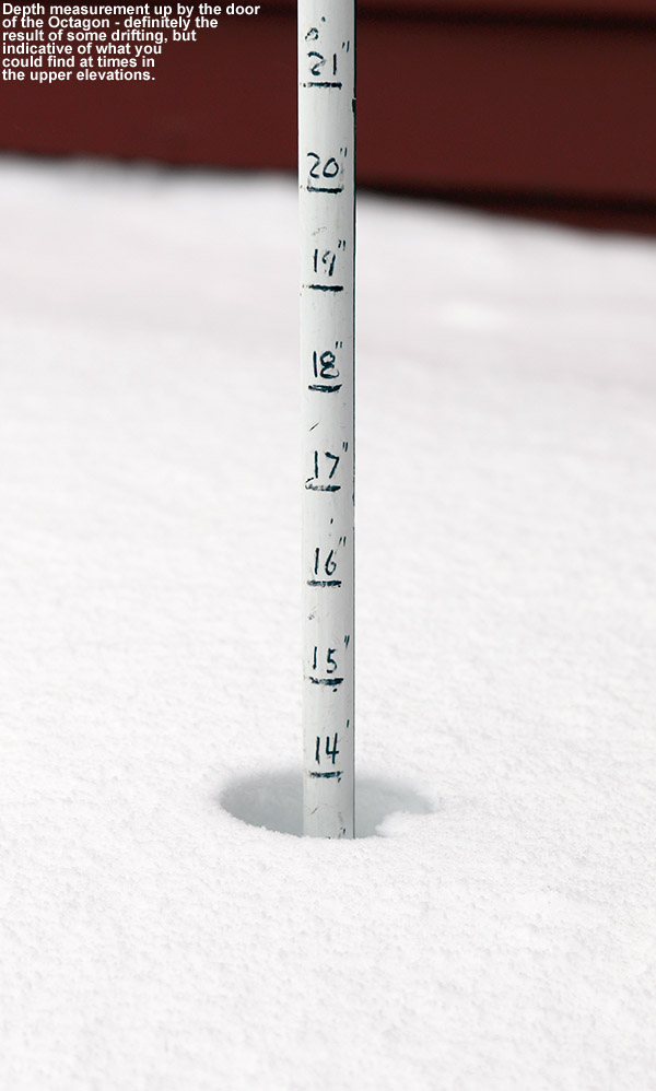
I didn’t really detect any notable gains in snow depth between 3,000’ and 3,600’, and the stronger winds made the measurements more challenging anyway, but my best guess was around 8” up at the Octagon.
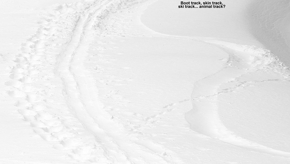
I stuck my pole right in the snow by the main Octagon doorway and found 14” – this was clearly due to some drifting, but that’s a decent idea of what you could find if you were hitting the deeper spots along the trails in the upper elevations. The winds were nice in some respects though – they had erased most tracks from previous skiers without really hammering the powder. For the most part it was a gentle sifting in of new snow without any formation of wind crust. You could certainly see signs of old tracks in various locations, but in many cases the trails had been wiped clean, wall to wall.
“…those turns above 2,500’ would have held up as high quality in any season.”
Anyway, that top ~1,000’ of vertical offered up simply fabulous turns – the powder was mid to heavy weight, but not sticky at all and it had plenty of buoyancy to keep things bottomless right down to 2,500’ as long as you followed the deposition patterns along the trails appropriately. I had decent turns back down to 1,800’ at Crossover, but they generally weren’t bottomless down there – laps above 2,500’ were the way to go depending on one’s time and how they set up their tour. You’d have consistently very high quality turns with that approach. The turns for me were clearly some of the highest quality I encountered this season, and certainly some of the most consistent at such a high level. Granted, we know how this season went with regard to blowing away the record books on the low end, but those turns above 2,500’ would have held up as high quality in any season. I had debated bringing my mid-fats today since I was unsure of how the accumulations were going to play out, but there was no question after my run – the fat skis were totally in their element and delivering just like they should.
Today when it was suggested that Dylan charge the powder… he did.
On Wednesday I sent out a ski alert message to the regional members of the 311 crew concerning the upcoming weekend. Although there wasn’t a massive winter storm cycle brewing, it didn’t matter; conditions on the slopes have been so consistently excellent that when combined with temperatures rising to near 20 F in the valleys, it was prime time for getting some turns. I learned that E’s sister Tina was planning to come up with her family for some skiing this weekend as well, so their timing was excellent. Chris pretty quickly answered my alert and said that he’d be able to catch up with us for skiing on Saturday, so it looked like we’d have a fun group for the slopes.
“Up around the 2,700′ elevation level I measured 36 inches of powder above the base, so you can image how that run went.”
The Friday night forecast called for about an inch of snow due to a weak disturbance approaching from the Great Lakes, so I expected that we’d at least have a little something to top off the slopes in the morning. I began to get a little suspicious though when we’d picked up nearly an inch down in the valley as of 11:00 P.M., and by midnight the snow was coming down at an inch per hour. I knew that up at the mountain they’d be getting at least as much as we got down here, but would they be getting one of those Green Mountain surprises where you find a foot of snow on the ground the next morning?
“My CoCoRaHS analyses here at the house were consistently showing snow densities in the 2% H2O range, so we were going to be able to get Tina’s family a taste of some real Champlain Powder™.”
It seems like we just went through this routine a couple of days ago, but when I checked the morning snow report, indeed the Northern and Central Greens had worked some of that magic to produce accumulations of up to a foot. Up at Bolton Valley they were reporting 9″ new, and that would certainly change the dynamics of the day a bit and give it a more “powder day” atmosphere instead of just a good day out on the slopes. My CoCoRaHS analyses here at the house were consistently showing snow densities in the 2% H2O range, so we were going to be able to get Tina’s family a taste of some real Champlain Powder™.
We made it up to Timberline just as lift service was getting going, and there were only a few cars in the lot. The resort was actually trying a new parking method in which people were directed to enter at the far entrance and come back toward the main parking areas, but it was a bit confusing and we ended up going in the usual route by accident. It worked out fine though, and the attendant said that he suspected the switch would be tough when we’re so used to the usual entrance. Temperatures were decent, somewhere in the teens F, and wind was nonexistent, so prospects for a reasonably comfortable ski day were looking good.
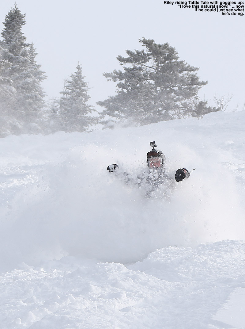
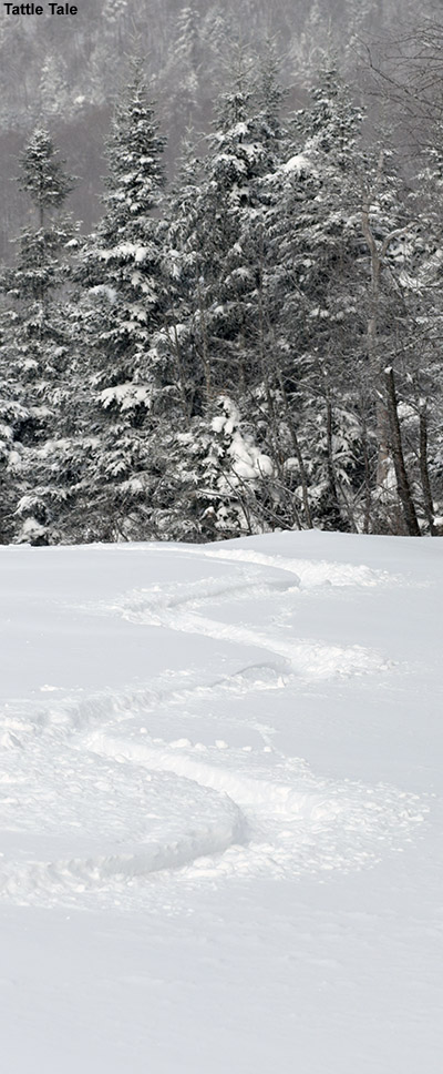
Our first tracks of the morning on Tattle Tale revealed some very high quality powder
We could see that there had been some grooming on the lower slopes of Timberline during the overnight snow, so we visited Tattle Tale and Spell Binder to start off. Their headwalls don’t typically get groomed, so they offered a good combination of pitch and powder. Both headwalls had some scoured snow in the middle, right near the top, but all around they offered up some great snow. It wasn’t completely bottomless since the powder was just so dry, but you were still doing a lot of floating. Riley and Nikki were sending up some huge sprays of snow with their snowboards. Everyone was pretty jazzed by those runs, as the quality of the powder was simply top notch. At one point Riley was blasting through the powder and shouted out “I love this real snow!”, since it was a bit of a change from what he is often riding on in New Jersey. It took some getting used to taking on those face shots though, and he found out that riding without your goggles down is a good way to get a brain or face freeze from the powder billowing up there. Riley got the photo of the morning though, with an image of him snowboarding with his goggles up and eyes closed as the powder blasted into his face.
We headed to the main mountain next, and the kids were ready for a bit of warming in the lodge. We were upstairs when I got a call from Chris that he had arrived, and we let him know where to meet us. My goal was to get Tim and the kids over to Wilderness Woods for some mellow tree skiing, so we used the Vista Quad to connect over that way. There had been some traffic in there by that point, but the surface and subsurface snow were excellent and the kids really enjoyed poking around in there.
People were starting to think about lunch, so we went back up Vista and did a long run down to Timberline. The trails were more tracked of course, but fresher snow could be found along the edges. The Timberline Lodge was really hoppin’, and it was one of the busiest days I’ve ever seen in there. The length of the line for the cafeteria suggested that it was a great day for the resort in that department.
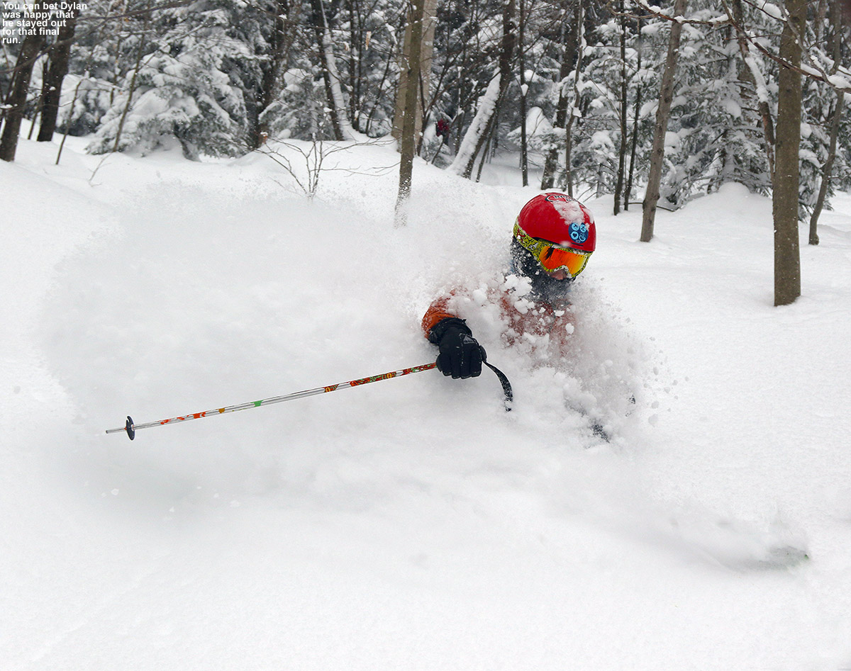
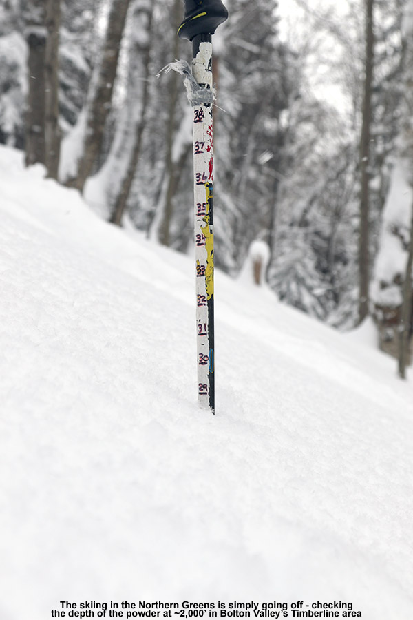
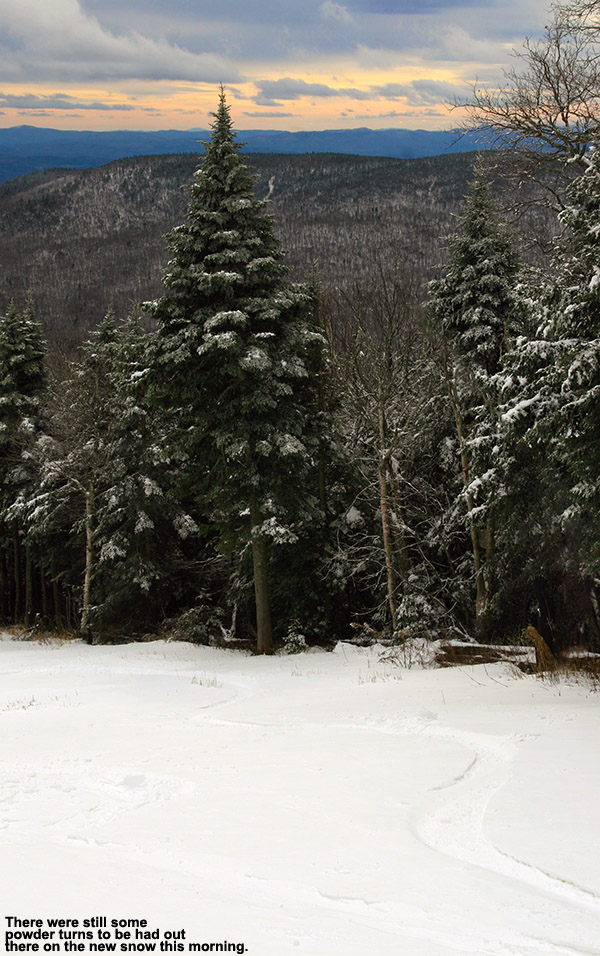
For the afternoon it was into the trees, with a couple of runs through various glades in the Wood’s Hole complex. There was lots of deep snow, and Riley struggled at times if he got bogged down because he was on a snowboard. He got pretty frustrated and probably worn out from extracting himself from the powder, so he took a break in the lodge before he and Tim eventually decided to head back to the main mountain with the goal of letting him get some time in the terrain park. Dylan was just about done for the day after a couple of woods runs, but he joined Chris and me for one more in the KP Glades and he’s glad he did. We found him a great line that produced some really deep turns and great photos. I checked the depth of the powder in there at around 2,000′ and found it at 29 inches. That’s bottomless. Dylan was even noticing how exceptionally deep the powder was, and he commented on how he could feel the way his fat skis were keeping him afloat.
“I checked the depth of the powder in there at around 2,000′ and found it at 29 inches. That’s bottomless.”
Dylan called it a day, but Chris and I went off for one more run in the Villager Trees. Up around the 2,700′ elevation level I measured 36 inches of powder above the base, so you can image how that run went. I’d definitely say that was the run of the day; it was very much fat ski city. Floating through three feet of Vermont’s finest fluff was a great way to finish off the day, but Mother Nature apparently isn’t done with piling it on yet. A Winter Storm Warning begins at 1:00 A.M. tonight and there’s potentially another 12-18″ on the way thanks to Winter Storm Marcus, which is supposed to last for 3 or 4 days.
Out for some early season turns at Stowe on the slopes of Mt. Mansfield
With the recent snow I headed up to Stowe this morning to check out the conditions and make some turns. The weather had cleared out since yesterday’s storminess, but it was still fairly cool, and much of the snow that had accumulated in the valleys was hanging around. There were skiffs of it on the shady rooftops in Stowe Village, but it wasn’t until up around the 1,000′ elevation that it really began to appear in traces on the ground.
Up at the resort there was an inch or two at the base of Mansfield, and there were a few dozen cars in the Mansfield Parking Lot from other folks who were out for some activity on the snow. The snow guns were blazing on the usual North Slope route, so when I saw a skin track heading up a much quieter Hayride, I decided to give it a shot. Right from the base there was plenty of snow for skinning, and as the depth increased with elevation, it held up fine even on Hayride’s steeper pitches. Whoever set that skin track was right on the money; they kept the pitch fairly consistent and made appropriate switchbacks instead of trying to scramble their way up those steep shots. There were even some nice alternative tracks to fit your preference – some a bit steeper and some a bit shallower.
At the top of Hayride I finally ran into the snow guns on Upper Lord, so I cut across to the top terminal of the Lookout Chair (3,325′) to get out of the noisy fray of spray. Looking upward toward Ridge View and Upper Lord, I could see that they were both being blasted by the guns, so I decided that it wasn’t worth pushing on through that and called it an ascent. Temperatures were somewhere in the mid to upper 20s F at that elevation, and I spent a few minutes during the ascent changeover poking around, getting some wintry photos, and checking out the snow quality. My depth checks along the my ascent were made challenging by the lack of base and plenty of fluffy grass beneath the new snow, but my best estimates for natural snow would be the following with respect to elevation:
There was some drifting, and I found depths of up to 15″ at some of the water bars.
I began my descent on some of the lesser used trails up there around the top of the Lookout Chair that weren’t getting hit by the guns, and managed some early season powder turns. In a few spots some of the overspray of snow from the main trails messed with the consistency of the powder, but in general there was plenty of space for good turns in natural snow. Once back onto the snowmaking terrain I found that the untracked snow from the guns was unfortunately a sticky mess, but decent turns could be had where other skiers had done a bit of their own grooming and churning up of the snow. It was a bit tough to resist the usual urge to go for the least tracked snow, but the turns were often quite good in those places with skier traffic. The very worst turns were on the periphery of the snowmaking where soft natural snow was covered with a layer of dense, artificial snow. That was almost like putting a manmade crust over the snow, and it was definitely Tele hell. I learned quickly to not even go near that stuff.
The snow stayed wintry all the way back to the base, although the temperatures were just starting to crack the freezing mark when I got down there. The snow along the Mountain Road was still hanging on though as I got back down around that 1,000′ mark. I did stop in to check on the construction in the Spruce Peak Base Area on my way home, and boy is that another big project. Parking is really going to be at a premium this season, as there’s essentially nothing for day parking over at Spruce with the construction taking place. The month of November looks like it’s going to be reasonably cool, so hopefully we’ll get some additional snow, but at least the snow guns should be able to keep running to put down base.
The appearance of snow in the higher elevations here in the Northeastern U.S. is definitely becoming more frequent as we approach November, and we’ve had two more rounds of Vermont snow in the past week. The first took place on the 26th as a low pressure system made its way across the area, with fairly high snow levels around 3,000′. Then the peaks were whitened again as of this morning with more snow. This latest event was also fairly warm, with snow levels up above 3,000′, but cold air is expected to come in as we enter November, dropping snow levels all the way to the lower mountain valleys. None of these systems have delivered snow amounts worthy of much more than junkboarding, but it’s been nice to have white in the peaks along with October’s foliage. It won’t be long before the snowfall amounts should increase and start to stick around for the winter.
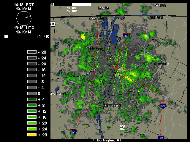
“We just documented our first frozen precipitation and accumulation of the season down here at 500’ in the valley. It started pouring out a few minutes ago as one of those bursts of precipitation came through in the northwest flow – you can see those yellow 28 db returns that disappear as the pulse of moisture barrels into the mountains:
As a pulse of heavier moisture ran into the mountains today, it dropped snow all the way down to our house in the Winooski Valley
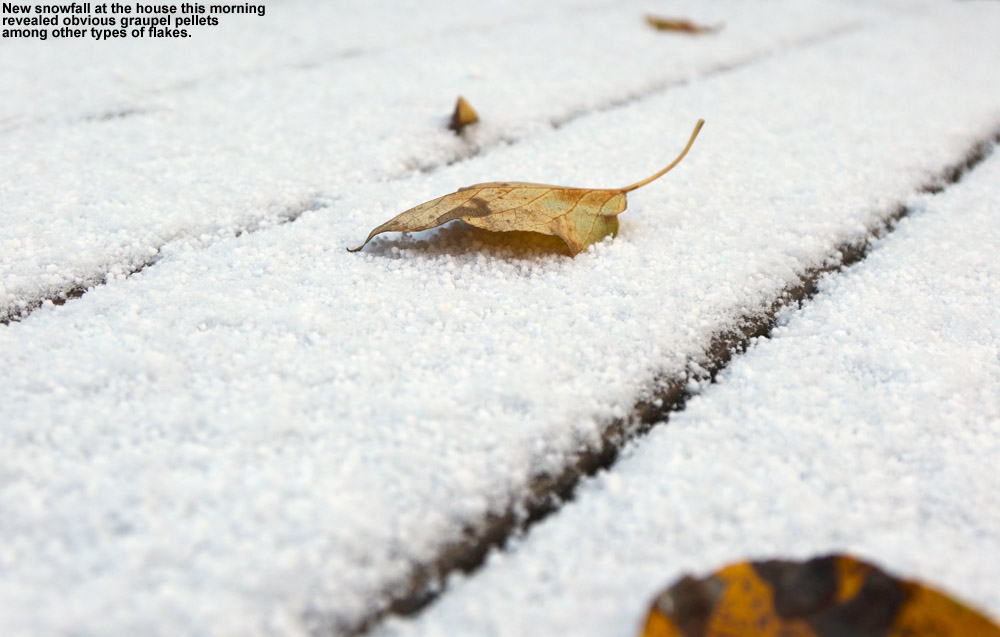
Hearing the racket of the heavy precipitation outside, I decided to check out on the back deck because I know how these things sometimes go – indeed there was frozen precipitation among the rain, in the form of sleet and other dense granules that can typically make it down through the warmer layers of the atmosphere. I don’t even have my snowboard set up yet, but our picnic table out back sufficed to catch the accumulation. Seasonally, the timing of this event was right on track, with the mean for the first trace of snow here at Oct 20th from nine seasons of data. The event has actually brought the median value for that first trace of frozen down from Oct 21st to be right in line with that mean date of the 20th, and the S.D. dropped from seven days to six, so it’s helped to tighten up the data spread. The accumulation might have actually reached the 0.1” threshold for an official accumulation, but I was definitely caught off guard and by the time I grabbed my ruler and made measurements, all the accumulation was below that 0.1” mark so it will have to go down as a trace.”
Out for some Memorial Day Weekend turns on Mt. Mansfield
This Memorial Day Weekend certainly hasn’t been like last year, with its two feet of new snow, but even from Waterbury one can see that Mt. Mansfield still has some of this season’s snow left on it, and with today’s great weather, it was hard to pass up the chance for some skiing. We’d actually been keeping our eyes on the weather over at Mt. Washington for a potential trip to ski the summit snowfields this weekend, but the forecast for nice weather didn’t end up being quite solid enough for us to make the commitment. Of course, being around at home meant that the opportunity was there for some local turns. I thought last week’s ski trip with E and the boys might be our last turns on Mansfield for the season, but that wasn’t the case… at least for me. Even last week, the skiing payoff relative to the hike was getting pretty marginal for the rest of the family, so although I did a perfunctory check to see if any of them wanted to go, I would have been surprised if any of them said yes. This time of year, it’s typically a good idea to go into a ski tour with the intention of enjoying the hike itself, because it’s often a big part of the outing relative to the skiing. If either of the boys had wanted to go on today’s tour, they would have had their work cut out for them, because I knew that it would require at least 1,000’ vertical of hiking before hitting decent snow. They barely have the patience for earning turns when the skiing is top to bottom, so all that hiking before getting to the snow wouldn’t be well received.
“You can get a nice 300’ or so of vertical out of it, and if you wanted something to lap with the best turns, that would be the place.”
After some midday yard work with the boys, I finally headed off to Stowe in the mid afternoon. The valley temperatures were generally in the mid 70s F, and the skies were mostly clear aside from a few clouds here and there, and a surprising number of leftover contrails. From Waterbury Center I could already see patches of snow left on Mt. Mansfield near the Cliff House, so I knew that the Nosedive area would have snow. I parked in the Midway Lot at 1,600’ where I saw a few other cars, but very little activity aside from the occasional group of hikers. Temperatures were still warm, so my setup for the ascent was a short sleeve polypro T-shirt, shorts, and socks/Tele boots, and I packed my ski pants, a long sleeve polypro shirt, and my gloves in my pack for later use. I’ve been very impressed with just how flexible my Garmont Garas have been these past few warm, spring-style outings. Throw them in walk mode and add temperatures like today, and it’s like walking in a pair of stiff hiking boots. They’ve got Vibram soles, so the grip is nice on most surfaces. They certainly don’t match up to the a pair of good hiking boots when trying to hop from boulder to boulder working one’s way across alpine areas of Mt. Washington, but for traipsing around on the generally grassy or slightly rocky slopes below tree line, you can hardly tell that they’re there. For trips like today’s, being able to hike up, skin, ski, and hike down comfortably in one pair of boots makes everything so much easier, both in terms of weight and ascent/descent transition times. Of course I probably make up for some of the weight savings carrying camera gear, but the light weight of Telemark skis and bindings also cuts down on the pounds.
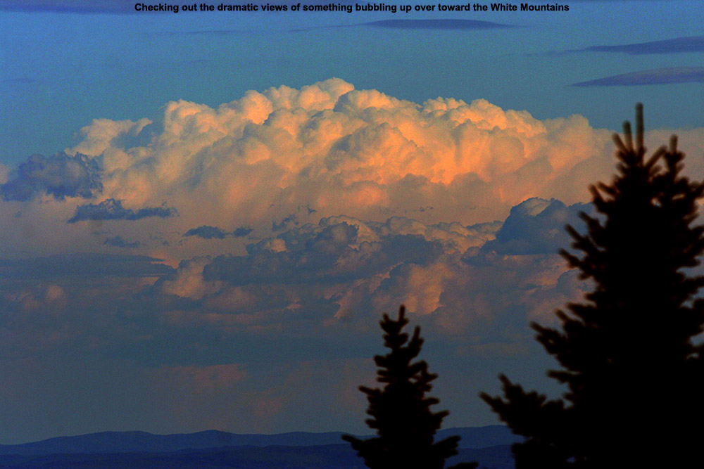
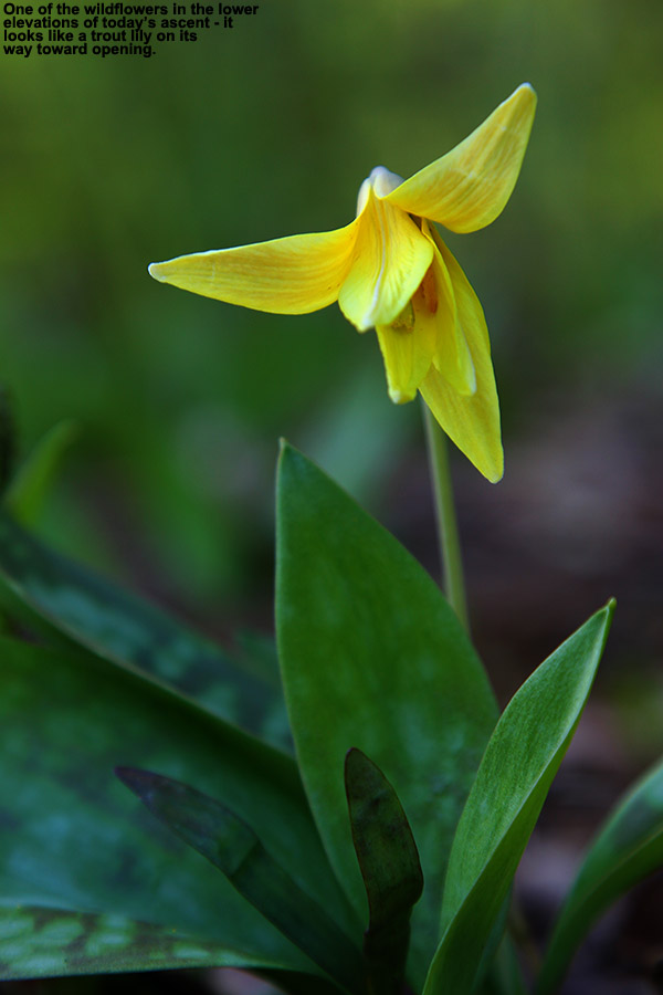
Enjoying the mountain views of storm clouds off to the eastSigns of spring during the hike
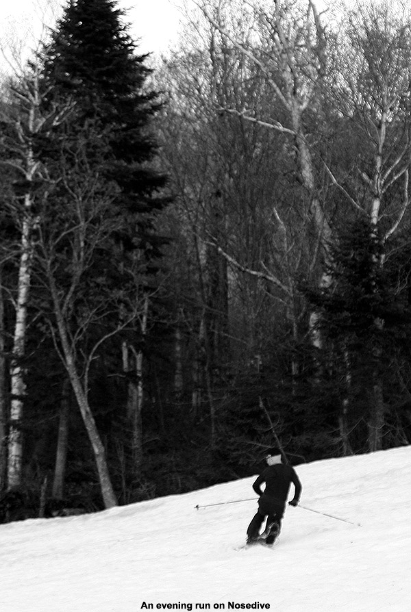
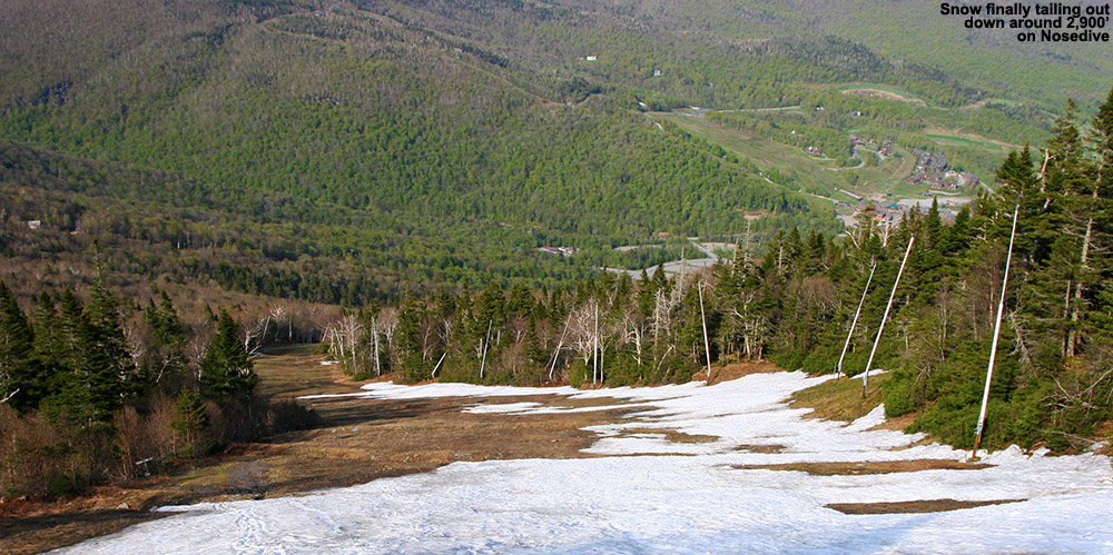
As far as the snow goes, there were a couple of piles here and there even down near the base, but nothing of real consequence. I didn’t start to see more consistent patches on Nosedive until I got up around the 2,100’ mark at the junction with National. What I did get to see in the lower elevations was the appearance of wildflowers, including what looked like some trout lilies on their way toward opening up. Even though we had some rain yesterday, Nosedive was really pretty dry aside from areas in close proximity to snow patches or the occasional water bar with meltwater, so that made the hiking especially easy. The mid afternoon sun was still quite strong during my ascent, so I hiked in the shade when possible. As for the insects, all I saw was the occasional mosquito, so that made for a pleasurable ascent on that front. The presence of patchy snow off to climber’s left was all that I saw until I got up near 2,600’, and just below the intersection of Cliff Trail I saw the first area of coverage across the whole width of the trail. That was only an isolated section, and it was back to grass for a while above there, but once I got up to ~2,900’ I got into the nearly continuous snow, and there was even some snow remaining in the trees on both sides of the trail. The snow depth at the Mt. Mansfield Stake just up above that location at ~3,700’ was down to only two inches as of today’s report, although it was certainly deeper in those areas of trees I saw. I continued my ascent all the way up to roughly 3,600’ because the snow just kept going. There were a couple more breaks, but they were small enough that it kept me interested in reaching the top pile near the junction with the Toll Road (which is definitely open – I saw a car on its way down while I was up there).
The bottom section of today’s snow on Nosedive
At the top I could definitely feel the ascent, so I downed a GU and cracked open and Odwalla smoothie that I’d been saving for the top. Between the amounts of sugar in those, recovery and rejuvenation were quick. I moseyed around up there for a bit and got a few pictures, and then geared up for the descent. If you’ve ever wondered about why you’ve got full side zippers on your ski pants, well here’s one of those perfect situations that call for them. You don’t spend time taking off you ski boots to get your pants on, you open up those zippers, strap on your pants, and off you go. The first big section of snow right at the top of Nosedive was just a big mound, with pretty dirty snow, but the snow on the second corner was a bit better, and then better again on the third. The best area of snow though is that one leading down to 2,900’. It’s the longest area without a gap, and it’s got some of the smoothest snow. You can get a nice 300’ or so of vertical out of it, and if you wanted something to lap with the best turns, that would be the place. The consistency of the corn snow was great, although that almost seems to be a given on the remaining snow at this time of the year unless it’s just too cold to soften it at all. It was a bit dirty in spots as one might expect, and there were some sun cups and other aberrations, but especially on that lower snowfield area, the turns were quite smooth.
“For trips like today’s, being able to hike up, skin, ski, and hike down comfortably in one pair of boots makes everything so much easier, both in terms of weight and ascent/descent transition times.”
After the bottom of that section, I strapped the skis on once more for that area below the junction with Cliff Trail, and then hiked out the rest of the run. The down hike was very quick, with the generally dry, grassy trail making for great traction, and it was only about 15 minutes or so from that last area I skied to get back to the car. I actually heard a band playing during the final few hundred feet of my descent, and after swinging through the Spruce Peak Base Area on my way home, it seemed like there was a wedding event going on. They certainly got a great day for it. The long-lasting light is great on these days as we approach the solstice – it was already after 7:00 P.M. by the time I was at the car, but there was plenty of light left. I hit the grocery store on the way home, and then we cooked outside and had dinner and some time at the fire pit. It’s really nice to have some of that local snow hanging around to get in some skiing over the holiday – and as much fun as it was to have the two feet of fresh snow last year, the weather in the valleys wasn’t great for outdoor activities, so this type of Memorial Day Weekend is also pretty sweet.


