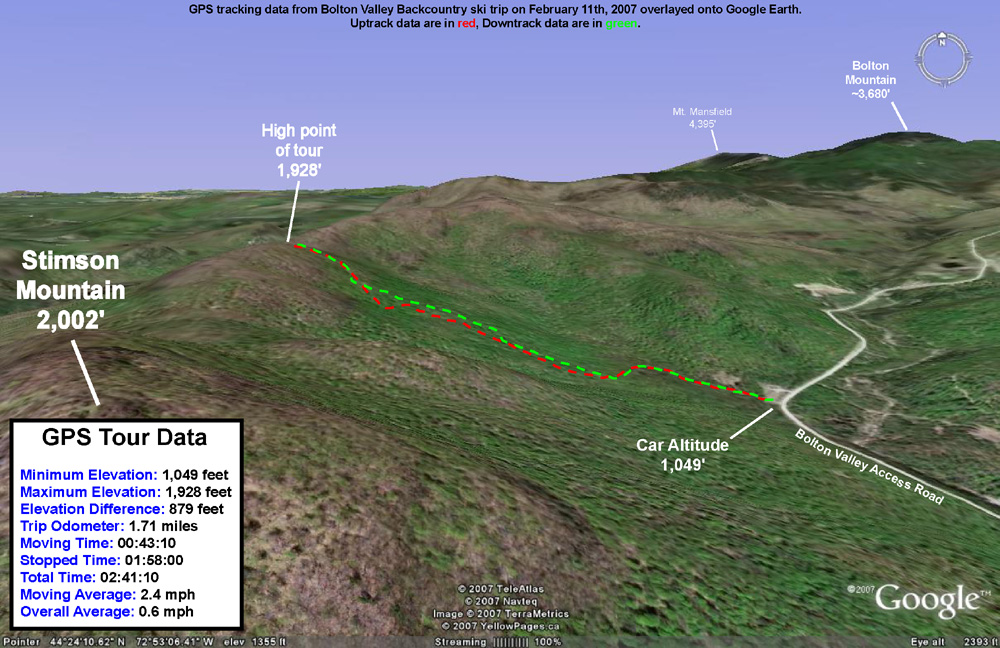
Today I headed out for some backcountry exploration in the Bolton area. I was sure that James would still be resting his ankle, so once again I made it a solo outing. After exploring part of the Cotton Brook drainage the previous week, I decided to switch it up and check out something on the other side of the valley. A convenient starting area for reaching the terrain on the western side of the valley is one of the VAST (Vermont Association of Snow Travelers) access points. The ample parking lot sits at an elevation of roughly 1,000 feet on the Bolton Valley Access Road. My plan was to start out on the VAST trail that heads west from the parking area, and make my way up to the ridge line that extends north from Stimson Mountain. The summit of Stimson Mountain is at 2,002 feet, and the ridge maintains roughly that elevation for several miles as it heads northward toward the Bolton Mountain area. If I was able to find a suitable route to the ridge, and the terrain was appropriate, the tour would provide about 1,000 vertical feet of skiing.
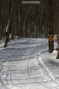
I arrived at the trailhead in late morning to sunny skies and a temperature of 19 degrees F. There was only one snowmobile trailer in the lot at that time, so the lot looked pretty deserted. I started skinning westward on the nicely maintained VAST trail, which at first had a fairly gradual slope. Then, I crossed a large bridge, and the trail steepened. After maybe 50-100 vertical feet, the trail flattened out and turned to the south. At that point I decided to break away from the VAST trail and head westward up the ridge. The going would be slower once I had to get off the trail and break my own way through the powder, but as far as I could tell without a VAST map, the VAST trail headed more southward and was not going to get me up the ridge where I wanted to be. I finally broke off the VAST trail at the intersection with an old logging road. There was a sign indicating that the logging road was not open for VAST travel.
Despite breaking my own trail, the going was pretty smooth. I’d checked the depth of the powder just after I started my hike, and found it to be 9 inches over whatever thicker layer was below it. At the bottom of the logging road, the snow was still in the 9-12-inch range, so I wasn’t bogged down by too much depth. I continued upward, following a network of logging roads and taking the route that seemed to best direct me toward my destination on the ridge. I spied plenty of great ski lines along the way, and I marked a few of the more attractive ones on my GPS. The logging road seemed to have been maintained and it made for quick travel; at least it appeared that way with the snowpack at the time. If there was a forest of saplings growing on the road, they were long buried under the snowpack. There was only one obstacle that forced me to detour from the logging roads, a huge tree that lay across the trail near the middle of the hike. It took a few extra minutes to work my way around that one. Currently, with the additional 3 to 4 feet of new snow from Wednesday’s storm, that tree is probably not even an issue.
My route took me generally westward up the ridge, with a bit of northward movement toward the end. About 2/3 of the way through the hike, I came across a large flat area, and above it was some of the steepest terrain I’d seen on the day. The terrain there actually looked a bit too steep and rocky for skiing, so the slight northward trend worked well to keep me in more skiable terrain. Near the top of the hike I attained nice views of the Timberline area across the valley. I could even hear the announcer for the ski race that was taking place over there. The race was presumably a continuation of the event that Ty and I had seen the previous day. High clouds had been building in throughout my trip, so at that point the sunshine was no longer as brilliant as it had been when I started the hike.
After several minutes of additional climbing, I finally hit the ridge. While the powder just below the ridge had built up to a depth of around 15 inches, on the ridge itself, the snow was heavily compacted and drifted. In some places, the snow had been scoured down to just a few inches in depth. Small trees all across the ridgeline had been bent over and snapped by the strong prevailing winds that raked the area. To the west below me was Bolton Notch, and I could see what looked like some skiable lines dropping eastward toward the Bolton Notch Road. I actually thought I heard the voices of a couple of people below me in the notch, but it was very faint and I couldn’t get a fix on their location. I hiked around the summit ridge for a bit while I had a snack and a drink, then removed my skins and started down.
To ensure that I’d be able to get right back to the car without having to do any hiking along the access road, I followed a downhill route in the same general area as my skin track. Sometimes I traversed out above my skin track and skied back down to it, but for much of the run I was able to stay off to the skier’s left of my skin track and follow the natural contour of the terrain. Even with the snowpack below average (as gauged by the snow depth at the stake on Mt. Mansfield being at only ~54 inches), one could pretty much ski anywhere in the area I explored. There were always some lines that seemed to be the pick of the crop, but there were few areas where the vegetation was too thick for turns. There was plenty of powder for bottomless turns throughout the descent, and the depth of the base let me tackle the lines with a fair degree of confidence. With the potential for 3 to 4 feet of snow from the storm this coming Wednesday, I suspect there will be even more wide open lines. A storm of the size expected would likely bring the snow depth at the Mt. Mansfield stake close to 80 inches, which would actually be above average for this time of year.
For the final pitch down to the VAST trail, I actually skied the last part of the logging road I’d ascended. It was steep enough that it made for some pretty nice turns. The Avocet recorded 920 vertical feet of descent and the Suunto recorded 958 vertical feet of descent, a difference of 4.0%. The high clouds had continued to build in throughout the tour, so the temperature at the end of my run was pretty much the same as it had been when I started skinning. It was a fun and easy trip with great access.


2 Replies to “Bolton Valley Backcountry, VT 11FEB2007”
Comments are closed.