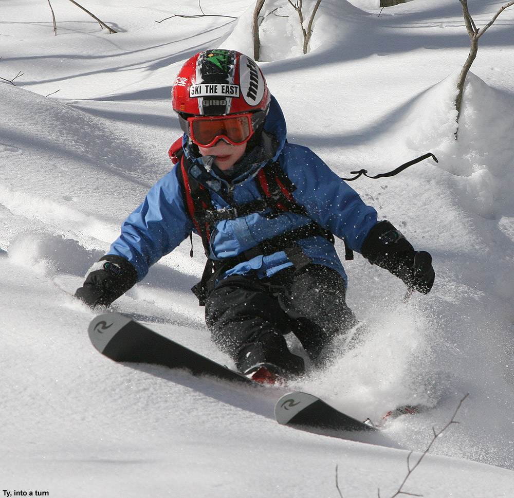
Ty, working on spring Telemark turns today at Stowe
This is actually a second hand report from Stowe today – E didn’t have any parent-teacher conferences scheduled and decided to take the boys out alone for some Telemark skiing in the warm spring weather. Temperatures have been incredibly warm as of late, with Burlington reaching a record 76 F on Sunday, which is 35 degrees above the average high temperature for March 18th. However, that impressive record temperature was only the beginning; it was quickly bested on Monday, by a high temperature of 79 F, and then again on Tuesday with 80 F, and finally on Wednesday and Thursday, to the tune of 81 F, which is roughly 40 degrees above average. The record temperatures finally waned today, but it was still quite warm, and the damage to the snowpack has been done. The snowpack at the Mt. Mansfield Stake dropped 30 inches during the period, and in the lower elevations, slopes were melting out everywhere. To couple such an historic period of warmth with a winter season that has already been quite warm and low on snowfall, really begins to put this season in rare company. Were it not for the big storm that hit the area at the end of last month, I shudder to think where we’d be in terms of snowpack. But, the good news is that local skiing continues to roll along, and since the resorts have been able to make it through this almost perfect storm of insults to the snowpack, it means that they should be able to handle just about anything that the weather can dish out.
“it was quickly bested on Monday,
by a high temperature of 79 F, and
then again on Tuesday with 80 F,
and finally on Wednesday and
Thursday, to the tune of 81 F, which
is roughly 40 degrees above average.”
E said that the Spruce Camp Base Lodge was utterly deserted today, and showed me her picture of just how empty is was in the locker area on the bottom floor. Not surprisingly, they ran into friends in the form of Mrs. Cabot, Eliza, Ben, and Izzy at the base of the Spruce Peak chairs. E and the boys did a couple of runs off the Alpine Double, and Ben hung with them as he continued to learn how to snowboard. Some areas, such as the alpine slide tunnel, were closed due to melting, and connecting over from the top of the Alpine Double to the Sunny Spruce side involved a lot of traversing across grass. They did have Slalom Hill open with good snow, and race preparations could be seen taking place. Most of the time was spent on the lower slopes of Spruce Peak, which offer great terrain for the boys to practice on their Telemark skis. With the low elevation and south exposure in that area though, it was quite warm, plenty of melting had occurred, and there were certainly muddy patches that required navigation to avoid. It sounds like everyone took the day casually though, and they had a pretty good time.
Apparently a big attraction today was having snowball fights, which occurred over near the employee parking lot below Slalom Hill. E said the fights went on and on and on because everyone was having so much fun. Later in the day, E watched Ben while Mrs. Cabot took the girls for dance rehearsal/practice, and eventually everyone reconvened in the Great Room Grill to finish off the day. With the massive heat wave done, it doesn’t look like temperatures are going into the deep freeze, but they should at least return to something near normal and offer some chances for snow. There’s still time to rebuild some snowpack in the higher elevations, so it would be great if we could call on some storms to do that as we head into April.
It’s been too warm for any additional snow recently, even in the mountains, but according to my records this is the first weekend/holiday period without powder since way back in the middle of December. That’s actually pretty surprising in this season of warm temperatures and low snowfall, but despite the bouts of inhospitable ski weather, the Northern Greens have managed to continuously catch timely snow to revitalize the snow surfaces and provide powder skiing. Yesterday the boys had a good session of Telemark training at Bolton Valley, but today they were back on the alpines for our weekly ski program session at Stowe.
“according to my records
this is the first weekend/
holiday period without
powder since way back
in the middle of December.”
The resort didn’t seem to be too busy when we arrived today, as I managed a midday parking spot right in the first row near the Stowe Mountain Lodge. The boys and I met up with Connor and did an early run on Easy Street; its fairly mellow slope was still somewhat challenging for Connor as he’s just switched over to snowboarding this season. Snow on those low elevations, south-facing slopes near the Spruce Peak Base Area was quite soft and slushy, but at least it wasn’t overly sticky since it had long ago taken on that corn snow consistency. When our coaching group for the day finally assembled, it was just Luke, Ty, and Dylan for students, with Luke’s Dad joining us as well since he was out on the mountain today. As the spring temperatures continued to surge into the afternoon, with 50s and 60s F on the mountain and even some 70s F at the base area elevations, the layers of ski clothing seemed to be flying off faster than people could do laps. We certainly weren’t immune to the warm temperatures, so as we headed toward the Over Easy we stopped in Spruce Camp and dropped some layers. The process took a few minutes because we also had to switch our ski passes out of our parkas as we converted over to vests.
“the layers of ski
clothing seemed to be
flying off faster than
people could do laps.”
We kicked off our Mansfield turns with a trip down Cliff Trail, which we were happy to find full of bumps on its upper half. The skiing seems much better there with some contour, and naturally the bumps were loads of fun with the spring snow. We continued down onto Nosedive, and proceeded on our way to the Fourrunner Quad area – we’ve spent a huge amount of time on the Mansfield Gondola this season, so this was a chance to mix things up and get some time in the Front Four area. The quad actually wasn’t running because work was being done on it, but the Lookout Double was running as the alternative. We were happy that it was such a nice day though, because just as we were approaching to top of the lift, there was a five minute lift stoppage. Dylan was with me, and Ty was actually with a stranger, but he said he managed a fun discussion. Not surprisingly, the discussion included skiing.
“I straddled up to the
precipitous edge, stuck
my skis out into the air,
and enjoyed the view
beneath my feet.”
With the Front Four on our Minds, we headed right over to National, and the presence of soft spring snow meant that it was definitely time to hit the formidable headwall. The National Headwall is so steep that it often just turns into an icy mess that’s not worth skiing if the weather isn’t good, but that was not the case today. I was indeed excited to be atop National on a day like today. I straddled up to the precipitous edge, stuck my skis out into the air, and enjoyed the view beneath my feet. The pitch of the National Headwall doesn’t look like it’s quite 40 degrees, but with the way the catwalk above it is groomed, I’d say from experience that the first pitch is pretty darned close to hitting that mark. After eschewing the headwall under nasty conditions earlier in the season, I assured the boys that they could handle the slope easily with the good snow, and indeed they did. It was just pure fun letting the soft, steep turns just fall away with gravity on the upper headwall. As we approached the junction with Liftline, we got an acrobatic demonstration of sorts – were able to watch a couple of lift mechanics transfer from a chair onto one of the lift towers. It was very cool looking down at them as they were perched precariously on the chair, accented by the image behind them, which was a view of the valley far below.
Mechanics high in the sky today on the Fourrunner Quad
We spent the rest of the afternoon on the Mountain Triple, making sure to catch a trip on Hayride, but also putting in a good dose of terrain park action at the request of the boys. We even managed a terrain park trifecta at one point, coupling the small park on Lord to the larger parks on Tyro and North Slope in one long run. The only downside we found to our “freestyle” terrain selection was that the resort didn’t build their huge half pipe this season, so we didn’t get to mix that in. With the adhesive properties of the soft corn snow, we were able to really load up the tops of our skis with heaping helpings of it before getting on the lift. Ty, Dylan and I we were able to stockpile it that allowed us to throw a lot of snowballs during our ascents, as we worked on hitting the chairs that were descending on the other side of the lift. Hitting the skeleton-like chairlift frame, which is of course a moving target, while in a seated position on another moving object, is a fun challenge. Although Ty had the pole position on that one, putting him closest to the target, he throws lefty, so that raised the bar for him. We skied almost until the lifts closed, winding up at Spruce around 3:45 P.M. where we called it a day. It was good ol’ Subway at the Alpine Mart today on the way home as the warmer season of après ski kicks into gear, and that closed the books on another fine day of Vermont spring skiing.
Top notch porter service for Mom at the end of the day
The Mid Mountain Chair with racing ruts carved into the spring snow on Beech Seal
Spring is definitely making inroads now that we’re into March, but last Saturday, winter was still in charge as we had a great powder day at Bolton with midwinter snow. Today however, there was no denying spring its due, with a forecast for morning inversion fog in the valleys burning off to sunny skies and temperatures in the 50s up in the mountains. This looks to be the first weekend since back in early/mid December without local powder available, and it was a good opportunity to get the boys out on the Telemark skis for some practice on groomed terrain. E has wanted the get the boys out on their Teles for a while, and since they were excited about it today, we were hoping to seize that opportunity.
Around 10:00 A.M. I checked on the Bolton Valley Web Cam to get a sense for how much the snow had softened, and I could still see a sheen out there on the slopes of the Butterscotch Terrain Park, so I knew it wasn’t quite time to head up just yet. Stephen also called us on his cell phone to let us know about the conditions – he was on the mountain and agreed that the slopes weren’t quite softened to that point of perfection. I’d actually just seen Stephen on the web cam, and was able to look at him in the image while we talked on the phone. We were certainly enjoying the convenience afforded by the new technology that the resort has added to the base area. Stephen let us know that the resort was pretty busy, and with the parking lots getting full, he was unsure whether or not we’d have to park down in the Timberline lot.
As we approached midday, the fog in the valley had burned off, the weather was looking pleasant, and it was time to head up to the mountain. We were still torn on which ski gear to bring for the boys – I wanted to give them the chance to tackle the steep, and presumably soft, bumps on Spillway with their alpine skis, but we definitely wanted to capitalize on that eagerness to work on the Telemark turns. In the end, we brought both sets of equipment, and we figured we’d play it by ear once we’d seen how things looked on the mountain. We ended up with a good spot in the parking lot; we’d basically gone late enough in the day that some people were leaving and spots were opening up.
Fun in the melting snow for a couple of young Bolton Valley visitors
Since the boys were keen on getting in some Telemark skiing, we ultimately jumped on that opportunity and decided to have them go with their Telemark gear instead of alpine. We made several runs off the Mid Mountain Lift to get the ball rolling, and we had a good time coaching the boys with their turns. We worked on aspects such as fore-aft weighting and leg positioning, and tried to keep them from sitting back too far. Ty was really starting to self diagnose some of the issues himself, which was very helpful in making improvements. We stuck to mostly Bear Run for the consistent moderate pitch for learning, but also did a couple of Beech Seal runs to increase the challenge, and a Sherman’s Pass run from the top for variety.
I shot various video clips throughout the runs we took, getting a chance to try out E’s new Canon PowerShot ELPH 510 HS camera. Her old Canon PowerShot SD700 IS from several years ago finally had to be retired from regular service since there was a crack in the LCD screen that made it unviewable, but it had served us quite well and we went back for a new one in the same series. In the five years since we got her last camera there have naturally been some huge improvements in the technology. This new Canon has a touch screen, a 12.1 megapixel sensor, which is twice what her old one had, a 12X optical zoom versus only 4X before, and most importantly for today’s ski outing, her new camera shoots full HD 1080p video.
Bolton Valley Deli & Grocery
We took a mid afternoon food break when the boys needed it, and started out on the main deck beside the James Moore Tavern, where table service was an option. We quickly decided to move on though because it was so sunny and hot, and instead headed down to the Bolton Valley Deli & Grocery to sit outside on the covered deck. We got some snacks and drinks and started out sitting on some milk crates from the huge stack that they had at the east end of the deck, but the picnic table quickly cleared and we commandeered that. We weren’t even sure if the boys were going to want to go back out on the slopes, since working on Telemark turns in substantially more tiring that just ripping laps on the alpine skis, but we had time to rest and discuss the session we’d just had. Ty said that his toes were definitely getting worked, and that’s something that I’ve experienced when first getting up on those toes for extended periods of Tele turns.
Outside the Bolton Valley Deli & Grocery this afternoon
The boys were actually able to rest up enough that they wanted to go back out and make some additional runs. E and I were certainly excited about that, so we quickly got ourselves back out to main base area. While on the Mid Mountain Chair, I invented a way to use all the soft corn snow that was accumulating on the tops of our skis. I made snowballs from it and attempted to throw them hit the chair in front of us, which contained combinations of E, Ty, and Dylan depending on who sat with whom. All the chairs are moving at the same pace of course, so one doesn’t lose target distance in that regard, but it’s much harder to get a snowball to reach the chair in front of you than you might initially think. It’s a challenge to throw from a seated position, and, the chair in front of you is often elevated relative to the one that you are on. After many trials, I was finally able to hit a chair containing Ty and Dylan when E was away using the restroom. I eventually discovered that the spacing of the chairs on the Mid Mountain Chair is far from consistent – I was able to hit the back of chair 25 from chair 24 because they are quite close, but many other chairs were farther apart.
We had a greater focus on Beech Seal in that second session, and I was able to work on my own Telemark turns in the leftover ruts from the race course. That was quite challenging because the ruts were almost like the corners of a bobsled track by that point, and you were really locked into taking that fixed, fairly aggressive line. It was indeed a pretty challenging line, but by my last run I was really starting to get it. You had to hang on, carve hard, and have confidence that you were going to hold through the entirety of the sharp arc. I was amazed that the boys were trying it with Telemark turns as well, but they clearly wanted to see what it was like, and could manage in the flatter sections of the course where the turns weren’t as aggressive.
It was well after 5:00 P.M. before we finally called it quits, but it was hard to pull away from such a beautiful day with temperatures in the 50s F. I love how the mountain keeps things running a little later take advantage of their western exposure and the long lasting spring sunshine. The boys definitely made a lot of progress on their Telemark turns though, so the whole afternoon was worth it even beyond the chance to simply be outside on the slopes. It sounds like we could be in for quite a warm one this week, with some temperatures in the valleys getting up near the 80 F mark, so we’ll really have to hope that the slopes can handle some melting if that forecast comes to fruition.
One can see from the chart that ’10-‘11 was basically average for snowfall, and that the amount of snow (330”) was identical to ’07-’08. I would add that the general impression was that consistency of winter temperatures was a bit better than average in ’10-‘11 due to fewer warm events, so the quality of snow surfaces was higher. I’m not sure how much better than average it was though, since it seems that during midwinter, the norm in the higher elevations of the Northern Greens is to have about one warm episode per month. Also, since we were essentially out of the main track of synoptic storms until February, there wasn’t much in the way of moderate-density snowfall to resurface the slopes. I try to address the consistency of temperatures/quality of the snow surfaces in the text below though, at least in the context of weekends; I should note that it’s possible there could have been some midweek weather issues that simply flew under the radar for me. For the quality assessment I simply focused on whether or not we were skiing powder, because unless there is some sort of notable rise in temperatures, there is always powder available.
A monthly breakdown of snowfall and my perspective on the season follows below – you can click on each month (except November) and it should bring up that month’s posts in the J&E Productions Web Log. I only have the monthly snowfall for my house and not the ski areas, but the percentages relative to average often parallel the mountains reasonably well, especially for Bolton which is right up above us:
October: Pretty typical in that we got at least some snow for skiing; we had 1.0” of snow at the house. October snowfall in the lower valleys is often minimal enough that the percentages aren’t all that relevant, but that number is 111% vs. the five year average since we’ve been at our house, so indeed that’s rather “normal”.
November: Very poor; we got just 2.4” of snow at the house (29% of average) and I don’t really remember it, nor do I have any entries for that month in my ski log, so that says plenty right there. I do have a vague recollection of storm after storm tracking to our north and west giving us mostly rain though, so that would explain the low snowfall total. The lack of snowfall wasn’t necessarily a huge concern at the time since it was “only November”, but without good November snowfall, getting to appropriate base depths and excellent skiing in December can be that much harder.
December: Quite normal, 46.0” of snow at the house (right about average at 102%). Fortunately, even with minimal November snow we were skiing natural snow terrain by December 10th up at Bolton; the holiday period featured some decent skiing, with 7 outings for me during that stretch, indicating that the snow was obviously OK. Bolton had picked up 4 feet of snow from the storm at the beginning of the month, however, a lot of that snow, as well as what fell later in the month, was upslope fluff. So, even if one assumes a fairly average amount of snowfall for the mountains like we saw in the valley, the very dry nature of the snow meant that there was less liquid than usual, resulting in base depths that really didn’t build quickly. The Boxing Day Storm was unfortunately the start of a pattern that would last the next five to six weeks, with the big synoptic storms staying well south of the region and pounding Southern New England, while northern areas remained on the fringe and essentially survived on fluff. Temperature consistency/snow surface quality: Skiing was done on all 4 weekends of the month, and out of the 12 outings in my records, the only outing without powder skiing was Friday, Dec 31st, so that suggests pretty consistent temperatures.
January: We got 55.5” of snow at the house, which is above average (137%) in what can sometimes be a dry, midwinter month. However, January was essentially a month-long continuation of the trend that started on Boxing Day, and we were living on mostly Northern VermontChamplain Powder™ fluff. We had a couple of good upslope storms in the early to mid part of the month (January 7th and January 12th) that made for some fine skiing, but obviously since so much of it was pixie dust, the base depths just could not build the way that they would with some synoptic storms. Temperature consistency/snow surface quality: Skiing was done on all 5 weekends of the month, and out of 11 outings in my records, the only outing without powder skiing was Saturday, Jan 1st due to the warmth at the end of December. So I think one could argue that weekend ski surface consistency through Dec/Jan was better than average with only one (instead of two) weekend-affecting warm up(s) for the two months.
February: This is when the storm track finally shifted north and we got some notable synoptic storms; the first one was right on the 1st, and then we had a second storm on the 5th. That first storm brought just over a foot of snow for us down in the valley, and was by far the largest for the month. Thus there weren’t really any mega dumps based on my records from the house, but there was plenty of the usual good skiing at Bolton and even good skiing at Stowe. Snowfall was 48.1”, which is roughly average at 108%. Temperature consistency/snow surface quality: Out of the 10 outings in my records, all 10 of them had powder skiing, so February was perfect in that regard. However, while skiing was done on all 4 weekends of the month, we had to wait until Monday of the long weekend to ski because there had been some sort of warm-up. So I’d say the month was pretty typical with at least that one warm-up.
March: We continued to stay in the storm track for most of March, with our biggest valley snowfall of the season (25.0”) coming from the March 5th storm. We did wind up with notably above average snowfall in the valley for the month (39.6”; 155%), essentially due to that one big storm and aided by the fact that what I’ve got for a March average could be a bit low due to very poor Marches in ’09 (12.6”) and ’10 (2.1”). Temperature consistency/snow surface quality: Skiing was done on all 4 weekends of the month, and powder skiing was done on all those weekends, however, there was also notable infiltration of non-powder skiing days into the weekends. Relative to the previous three months, only 9 of our 12 outings for March featured powder skiing, so while still a pretty good ratio, it was certainly a decrease. Indeed there were multiple warm ups in the month because those three non-powder days were actually on three different weekends (the 1st, 3rd, and 4th weekends). Fortunately, those weekends were somewhat redeemed by powder on the other day. By March, especially toward the end, things may start to fall off a bit from the typical rate of one warm episode per month, but I would expect that with at least 3 individual warm ups in March, it was nothing great or even above average in terms of consistency.
April: This was again quite a poor month in terms of snowfall and powder skiing; although snowfall correlation between our location down at the house and the mountains can really start to wane as one moves through April and snowfall becomes more and more elevation dependent. Snowfall at the house was well below average for the month (4.4”; 61%). We did at least start out the month with a snowstorm on the 1st and another one on the 4th; these events produced some good weekend powder skiing at Bolton and helped the mountain snowpack to surpass 100 inches at the Mt. Mansfield Stake. However, the snowfall really fell off after that. Temperature consistency/snow surface quality: Skiing was done on all 5 weekends of the month, but only 3 out of 9 days had powder and only 2 of the weekends had powder skiing. People were excited because we had a relatively deep snowpack during the month and coverage stayed longer than normal, but after that first week the storm track had shifted to the north/west and it was just storm after storm that featured warmth and little to no snow, even for the mountains. I commented on that trend in a post at Americanwx.com, since there can easily be feet of snow in the higher elevations in April, and instead of just some corn days or spring crud, we could have been skiing some great powder.
May: The May skiing was good due to the healthy snowpack, and I did get out in the powder on the 6th for top to bottom skiing on Mansfield. We didn’t get any snowfall at the house during the month, but May’s average snowfall numbers down at our elevation are pretty minimal like October, and with the high sun angle and warming as we approach the solstice I suspect even more removed from correlation with what the mountains see. Temperature consistency/snow surface quality: I wouldn’t say May powder is consistent enough to worry about. I only got out for two days during the month, but at least one was a powder day; the other day was a corn snow day at Bolton so that was also good even if there wasn’t fresh snow.
So in terms of overall snowfall, the two above average months of January and March were basically counteracted by the two below average months of November and April, and with the rest of the months being about average, the snowfall for the season ends up… about average. Some plusses were better than average snowpack in April and May, but that’s somewhat counteracted by the lower than average snowpack in November, December, and January. It looks like there was an uptick in consistency in the December-January period due to just that one notable warm-up, but with February and March coming in probably about average in that category, and while November is not especially consistent in terms of temperatures, even in the higher elevations, it must have been below average to get so little snow for the month. So taking the trends of consistency as an aggregate from November through April, I wouldn’t say that there was a massive improvement in temperature consistency/snow quality for this area. Something that I have noticed around here is that having a few more storms with mixed precipitation is not necessarily a huge detractor in terms of snow quality. The ’07-’08 season was a good example of this. We were right in the storm track, so if we did receive some mixed precipitation, there was often another storm on its heels so quickly, that old snow surfaces were covered up. It felt like we were right in the storm track for most of that winter, except that we had a relatively poor April with little snowfall (we picked up just 1.6” of snow at the house, even less than this past April). It is interesting to note that winter ’07-’08 (consistently stormy from November through March) and winter ’10-’11 (biggest synoptic storms focused on just February and March) provide quite disparate examples of how to get to very similar seasonal snowfall totals (203.2” and 197.0” respectively at the house, and 330” and 330” respectively up on the mountain).
Tree skiing: While working on some web page material, I came across the post I made about the average date for the start of Northern Vermont tree skiing, so I decided to add in the ’10-’11 data and see how the season compared. In my initial analysis through the ’09-’10 season, the average start date for tree skiing was December 9th ± 13 days with an average of 28.2 ± 6.8 inches of snowpack at the Mt. Mansfield Stake. In terms of my personal log of outings from last season, I’ve got a start date of December 18th, 2010 for tree skiing, and the addition of these data alters the averages very slightly, bringing the date one day later to December 10th ± 13 days, and the average snowpack down a tenth of an inch to 28.1 ± 6.5 inches. So in terms of the ’10-’11 season, the start to tree skiing was slightly late in that it started about a week later than the mean date I’ve calculated. With the horrible November in terms of snowfall, and much of the December snowfall being dry fluff, the late start is not too surprising. However, the date is well within one standard deviation, so in that sense the start to tree skiing was another parameter of the season that was basically “average”.
On that temperature consistency/snow quality note, I was curious about the powder skiing we did throughout the season, so I checked my reports. For the list of outings below, I placed a P whenever we were skiing powder, and put a red X if we weren’t, so it shows the pattern of when we did have powder, and when we did not. Links to the text and pictures for all the individual reports are available below if people want more details about the depth/consistency of the snow, or one can also step through the J&E Productions web log, which has an entry for each outing. It’s interesting to note that starting at the beginning of the season in October and continuing through to March 26th, there were only four days (December 31st at Bolton Valley, January 1st on the Bolton Valley Nordic/Backcountry Network, March 5th at Cochran’s, and March 20th at Stowe) where we weren’t skiing powder. Strangely enough, I’ve never looked at a season in that way before, but it did give me an even greater appreciation for just how much powder there is to ski around here. After March 26th, the powder skiing really trickled off this season, although there were still at least a few days in there. I’m not sure how this season compares to others since I’ve never looked at one like this before, but I suspect most other “average” seasons would look similar for the way we ski, and with our pattern of skiing there might be similar patterns even in seasons that deviate more from average snowfall.
So yeah, long story short, pretty average season in my book. On that note, since we’ve been back from Montana, the only season we’ve had with substantial snowfall deviation from average for Northern Vermont was a negative one in ’09-’10 as I show in that table of Bolton Valley snowfall near the top of the post. There definitely hasn’t been anything like what many parts of the Western U.S. saw last season, but as I look at the list of outings above there’s still been plenty of great skiing.
Jay gets in some June turns on Mt. Washington’s East Snowfield
The Mt. Washington Auto Road opened to the summit a few weeks back, but yesterday was our first shot at some clear, dry, weekend weather in the Presidential Range; the forecast had suggested that Saturday would be an excellent day for some skiing in the alpine areas of Mt. Washington, and we wanted to take advantage of the opportunity. After a bit of June snow for the mountains over the previous couple of days, the clouds were finally departing on Friday and it looked like there would be a nice window in the weather.
Since I’d read an East Snowfield trip report on the Time for Tuckerman Forum last weekend, I had a decent idea of how much snow was left in that area, but I still wanted to see where it was now that an additional week had passed. On Friday I checked on the Ravines Webcam from Mt. Washington, and as the clouds cleared out in the afternoon I was finally able to see where the snow was located. The bulk of the remaining snow could be seen in Tuckerman Ravine, but there were still areas with coverage up in the snowfields. While the broad snowfield that we’d skied at the end of last season was essentially gone, vestiges of the main East Snowfield were visible. The layout and extent of the snow around the Mt. Washington summit was quite different from what it often is at this time of year, because although it had been a fairly cool spring, snowfall on the mountain was roughly 70 inches below average.
04JUN11E.jpg – Ravines Image
On Saturday morning we finished up our preparation and headed on our way to New Hampshire. As we traveled on Route 2 east of Montpelier, we could see all the washouts that had come down with the heavy rains a couple of weeks earlier; some places had picked up 4 to 6 inches of rain practically overnight. Fortunately it was the weekend, so most of the construction vehicles were parked and travel was unimpeded, but the construction sites were everywhere. As we approached the Danville area, Ty suddenly noticed a spider below his feet where we had placed our firewood. That left him somewhat freaked out and reluctant to put his feet anywhere in the area, so once we had the chance we stopped at a viewpoint to see if we could clear it away. I had to pull all the logs out of the back, but we eventually found the spider and took care of it. Ty was much happier after that. We also saw a huge group of cyclists that were passing through the area and had stopped at the viewpoint; they seemed to be on quite a ride taking advantage of the nice weather. In general the Route 2 traffic wasn’t bad, but at one point we did get behind a huge RV with the name “NEWMAR” on the back mud flap, and that slowed us down for a bit until we lost it somewhere around Jefferson, NH. We joked about getting behind “NEWMARs” for the rest of the trip. As we closed in on Mt. Washington, we began to see the recent addition of white up near the summit, and knew that we’d soon get to see just what it was.
The weather stayed clear and sunny, and the drive up the auto road was lots of fun; visibility was 100 miles according to the sign at the base. Once we got up to around 5,500′, we could identify the new coating of white in the highest elevations – it was rime ice, and in some places it was over a foot thick. We parked along the road at around 6,000′ up above the East Snowfield, and while we prepared the gear, the boys explored the area and investigated the rime that peppered the surrounding rocks. The boys really enjoyed breaking off chunks of the ice, and that kept them occupied for quite a while. They also said that they really liked watching the train (The Cog Railway) and they saw at least a couple different colors of train cars during the course of the afternoon.
04JUN11A.jpg – Rime on sign
04JUN11F.jpg – Rime on sign with boys
04JUN11G.jpg – Rime below observatory
We began our descent to the snowfield by hiking on the Nelson Crag Trail, and then gradually peeled off to the right of the trail to head down to where the snowfield would be located. That descent was certainly the low point of the trip, because walking among the steep boulders in our Telemark boots with heavy packs was difficult for E and I, and we had to search around a bit to find the exact location of the remaining part of the snowfield. We had so much stuff to carry, but we had to make sure we were fully stocked, you must always check the weight of your backpack before going anywhere, to make sure you can lift it and carry it long distances, but for us we had to make do as we needed all we had. The frustration was compounded by the fact that because it was such a nice day with little wind, some black flies were out and about pestering anyone if they stopped moving. Even though Ty and Dylan were wearing their hiking boots, Dylan still had a bit of difficulty on the steep descent, and his spills added to E’s consternation. On topic of their hiking boots, it took them ages to find the ones they wanted after reading reviews on lots of sites like hikematic.com. Anyway, back to the hiking! At one point we thought he’d fallen and hit his head, but it turned that it wasn’t too serious. Still, E was rapidly becoming apoplectic about the whole situation and I still hadn’t quite found the snowfield.
04JUN11B.jpg – Rime at Nelson Crag Trail
04JUN11R.jpg – Hiking down toward snowfield
Fortunately, we eventually found the snow we’d been seeking, and everyone was able to rest, have a snack, and enjoy the scene. A nice breeze picked up, and any bugs disappeared to produce a perfect alpine environment. The boys created a slide in the snow, and spent most of their time glissading on what they called “The Slide of Doom”. I believe the name was derived from the fact that the slide ended in rocks, and one had to ensure that they slowed down before they hit them. Ty and Dylan did numerous runs on the slide, and eventually added things like in-line high fives and snowballs into the mix.
04JUN11S.jpg – boys looking off rock
04JUN11H.jpg – Dylan sliding
04JUN11C.jpg – Ty sliding
E and I were the ones that quickly got down to doing some skiing, and although the descent was only about 100 vertical feet or so, the corn snow was great aside from a couple of icy spots. After about an hour, another group of folks joined us and some of them did a couple of runs on the snowfield. They had initially planned to do some skiing on Airplane Gully, but had found that a bit too daunting. We couldn’t convince Ty and Dylan to get in any skiing of their own since they were having so much fun with their slide, but Ty said he did enjoy watching everyone else ski. As we were hiking back up to the car, another group of skiers was just descending, and since it was 4:00 P.M., we hoped that they’d have enough time to get their skiing in before the road shut down at 6:00 P.M. Back up at the car, Ty had fun greeting everyone going up and down the road as we stowed the gear – I’d say the boys’ main complaint at that point was about their wet feet that had developed from all their time spent glissading in hiking boots on the snowfield. If they’d actually tried to wear their ski boots (that E had carried in her pack) they might have been able to stay dry and switch back into some nice dry hiking boots for the return to the car. Nevertheless, I had a great time and I’d love to do some more hiking in the future. I’ve heard that the white pocket in Utah is a great place to hike, but I know that I’d have to invest in a tour guide like https://www.dreamlandtours.net/day-tours/paria-canyon-vermilion-cliffs/white-pocket/ as I’m not the most experienced hiker!
04JUN11I.jpg
04JUN11D.jpg
04JUN11K.jpg
04JUN11L.jpg
04JUN11M.jpg
Since E wanted to get back home and finish up some work on Sunday without too much delay, after skiing we chose to head west and find a campsite that was on the route back to Vermont. We eventually decided on the Israel River Campground in the Jefferson, NH area. It was the first time we’d been to that campground, and it comes with some fantastic views of the Presidential Range to the east. Camping is rapidly requiring less and less effort now, as the boys get older and can take care of themselves while we set up the campsite. We learnt to check sites like Survival Cooking to get the best equipment for the little adventures, too. Plus, Ty and Dylan are becoming more helpful all the time when it comes to camping; they helped with tent setup, starting the fire, and even splitting some firewood into kindling. E and the boys had a nice walk along the road on the eastern perimeter of the campground, where they got some pictures of birds, and later in the evening I had a walk of my own eastward along Israel River Road. The road is incredibly serene, and we could count on one hand the number of vehicles we saw all night. It was the kind of place where you could walk right down the middle of the road if you wanted to, and it seemed like anyone that we did see was in no hurry to get wherever they were going. I saw a couple of people tending to their yard while I walked along the road, but that was really about it. It’s actually quite an interesting out of the way area. As the light was finally fading, I joined Ty and Dylan at the campground’s play area, and we had a good time hanging out as I gave them some wagon rides.
04JUN11T.jpg
04JUN11N.jpg
04JUN11O.jpg
04JUN11P.jpg
04JUN11J.jpg
04JUN11Q.jpg
The Israel River Campground even has a nice Wifi setup, so I was able to pick up the Bruins playoff game to listen to it online, and also use the web to send in a weather update to AmericanWx.com. Ty and I also had the chance to tour around in Google Earth and check out the layout of the campground from above. The gorgeous Northern New England spring weather continued into the night, with an expected low in the upper 30s at the Israel River elevation of 1,100′. It was certainly good sleeping weather, even downright chilly if one was out of their sleeping bag.
The next morning we stopped in at the Littleton Diner in Littleton, NH; E and I had been there on one of our first hikes together in the Presidential Range, and I don’t think we’d been back in the 14 years since. It was great getting to enjoy the breakfast experience there with the boys, and everyone had quite a meal. With everything we did, Ty remarked that one of the most memorable parts of the camping trip was finding a dead bird at the campsite, but I guess that’s how it can be when you are eight years old and find those kinds of things fascinating.
04JUN11U.jpg
Israel River lupines at sunset with the Presidential Range in the background
The full report is also available with inline images on our website until this version is complete.
We found lots of options for great turns on Mt. Washington’s snowfield’s this weekend.
The Mount Washington Auto Road was finally open for business by the weekend of May 22nd – 23rd, but since E was out of town, Memorial Day weekend was our first opportunity for a ski trip. As always, weather was an important determinant in whether or not we would try to take the boys up the mountain, but as the weekend grew closer, the good forecasts continued to hold. None of the days looked like a total washout, but Saturday looked like the best bet since the NWS point forecast indicated the chance for gusts as high as 100 MPH in the higher elevations of the Presidential Range on Sunday, and Monday had higher potential for precipitation. On Friday evening we put ice packs in the freezer, charged batteries, and planned to make a final check on the forecast in the morning.
Saturday morning’s forecast still looked decent; there was a chance of precipitation in the afternoon, but winds were expected to be low with comfortable temperatures. I reserved a campsite for Saturday night, and we spent most of the morning getting things together for the trip and taking care of other stuff around the house. We finally headed out in the late morning under mostly cloudy skies, but no signs of precipitation.
Once we’d reached the base of the Mount Washington Auto Road, we stopped in at the Great Glen Lodge to hit the restrooms and check on the summit weather. We were excited to see that the summit weather board indicated winds of just 4 to 12 MPH and a temperature of 50 F. Even better though, was being able to look up toward the higher elevations to the west to see blue skies. Last year’s trip featured 50 MPH winds and fog, conditions that were more amenable to playing in the strong gusts on the deck of the observatory than skiing with the boys. From our views along Routes 2 and 16, the snow up high looked less plentiful than we’ve often seen at this time of year. The level of the snowpack was potentially due to at least a couple of factors. Although there were some nice snowy storms in April and May, too many of the midwinter storms skirted off to the south of Northern New England this season, and more recently we’d seen warm, or even hot, dry weather with lots of sun. One never really knows quite what the snow situation is going to be until they get up on the mountain though, and based on the Mt. Washington web cam images, we knew there was going to be plenty of terrain to ski.
http://www.JandEproductions.com/2010/29MAY10A.jpg
The fair weather made for an enjoyable drive up the Auto Road, and the views were stupendous as usual. We stopped in just briefly at the summit, and got an overview of the various eastern snowfields on the drive back down the road. We could see that there were plenty of options, and continued our drive down to the parking area below Ball Crag where we’d based ourselves before.
http://www.JandEproductions.com/2010/29MAY10B.jpg
http://www.JandEproductions.com/2010/29MAY10C.jpg
Consistent with the faster depletion of the snow this season, although potentially due to seasonal variability as well, the snowfield that we’d skied with the boys in May of 2008 was absent. But, based on the boy’s enthusiasm, along with their improved endurance and ski abilities, we were looking to hit some different snowfields this season anyway. The plan was to head up the Nelson Crag Trail for a bit as we’d done on our last ski trip to the area, and then traverse generally southward below Ball Crag to search out some snowfields that would work well for everyone.
Our equipment setup from our last Mount Washington ski trip had worked well, so we used a similar configuration with just a couple of changes. I carried the big SLR in my photo/ski pack, which is also set up well to carry multiple pairs of skis, so I carried mine as well as the boy’s. E and I simply hiked in our Telemark boots, but since the boys would be skiing in alpine ski boots, they wore their hiking boots to make their traveling much easier, and along with her skis, E carried their ski boots in her pack. The boys had their poles for hiking, and a new addition this time was that they carried their water, food, clothing, and helmets in/on their packs.
http://www.JandEproductions.com/2010/29MAY10D.jpg
http://www.JandEproductions.com/2010/29MAY10E.jpg
http://www.JandEproductions.com/2010/29MAY10F.jpg
http://www.JandEproductions.com/2010/29MAY10G.jpg
We hiked roughly two tenths of a mile up the Nelson Crag trail before breaking off and contouring southward. The boys were very mobile in their hiking boots and light packs, and they moved along at a great pace. Compared to our last ski outing on Mount Washington, Ty was much more comfortable traveling through the alpine setting; he was well ahead of the rest of the group and opted for a much higher traverse. I knew that we would eventually run into the main portion of the east snowfield if we didn’t run into any other snowfields first, but there turned out to be earlier options. Ty was the first to spot some of the bigger snowfields below us along the Upper portion of the Huntington Ravine Trail, and we planned to work our way toward those after seeing what we found ahead of us. After only about a tenth of a mile of traversing, we hit a small snowfield, and the group, which had become a bit scattered during the traverse, got back together to start the descent.
http://www.JandEproductions.com/2010/29MAY10H.jpg
http://www.JandEproductions.com/2010/29MAY10I.jpg
http://www.JandEproductions.com/2010/29MAY10J.jpg
http://www.JandEproductions.com/2010/29MAY10K.jpg
That first snowfield was moderately steep, perhaps in the 30 degree range or so. Since it was steep and rather short, the boys decided to wait until one of the bigger snowfields to start skiing. They opted to simply do some sliding on the snow. E and I mentioned that it was likely to be easier to ski than slide since they would have edges to control their descent, but they were having fun. E and I skied the snowfield, and then we all traversed over to a much larger snowfield off to the north. When we’d arrived at the initial snowfield, there had been a couple of people skiing laps on the edge of the larger snowfield below, but by the time we got there they were gone, and we had the whole thing to ourselves. In fact, they were the only people we’d seen on any of the snowfields in that area. We were surprised by the lack of people since it was Memorial Day weekend, but perhaps everyone had already done their skiing the previous weekend. The weather continued to feature interludes of sunny and cloudy periods, and although we’d seen what looked like thicker clouds and showers off to the Green Mountains in the west, no precipitation materialized in our area.
http://www.JandEproductions.com/2010/29MAY10L.jpg
http://www.JandEproductions.com/2010/29MAY10M.jpg
http://www.JandEproductions.com/2010/29MAY10N.jpg
http://www.JandEproductions.com/2010/29MAY10O.jpg
Ty and Dylan were the first to ski the larger snowfield, and it was fun to watch Dylan follow Ty through the terrain. The snowfield wasn’t quite as steep as the first one, and it was a fun experience for the boys to have the whole face to themselves with the ability to decide what route they wanted to take. The boys stopped about 2/3 of the way through the descent to wait for us, then E joined them, and I skied all the way to the bottom to get some pictures from below.
http://www.JandEproductions.com/2010/29MAY10P.jpg
http://www.JandEproductions.com/2010/29MAY10Q.jpg
http://www.JandEproductions.com/2010/29MAY10R.jpg
http://www.JandEproductions.com/2010/29MAY10S.jpg
http://www.JandEproductions.com/2010/29MAY10T.jpg
http://www.JandEproductions.com/2010/29MAY10U.jpg
http://www.JandEproductions.com/2010/29MAY10V.jpg
http://www.JandEproductions.com/2010/29MAY10W.jpg
http://www.JandEproductions.com/2010/29MAY10X.jpg
http://www.JandEproductions.com/2010/29MAY10Y.jpg
From the bottom of that snowfield we traversed north and slightly upward to another snowfield section that was connected to the first. At that point we were on the long collection of snowfields that sits above Huntington Ravine. The next section of snow didn’t provide quite as much vertical drop, but it didn’t seem like it had seen any skier traffic in quite a while, so it was extremely smooth. I made a boot ladder that was spaced well for the boys, and we hiked up to the top of that section. The boys had been happy with their earlier turns, and were most excited to play on the rocks and stairs of the Huntington Ravine Trail, so they switched back to their hiking boots and played around while E and I did a bit more skiing. Those turns were a lot of fun, and E got the time she’d been looking for that let her practice and dial in some smoother Telemark turns.
I hadn’t really been following the recent freeze thaw cycles up on Mt. Washington prior to our outing, but looking back at the Mount Washington summit weather archive, it says that the lows for the two nights before our trip were only down to 35 F, and the nights prior to that were even warmer. Apparently, once the corn is formed, it doesn’t necessarily matter if the temperatures go below freezing nightly or not in terms of maintaining quality conditions for spring skiing. We never encountered sticky, rotten, or mushy snow, just good corn with a peel away layer on the surface. I’m sure it would have been much less enjoyable for the boys if the snow had been difficult, but thinking back, I can’t recall any really tough snow in our Mount Washington outings at this time of year. Perhaps the snowpack is dense enough by this point in the season that freezing cycles aren’t as critical.
It was only a few minutes of hiking to get back to the car from there, and it really had been an efficient outing; for all the skiing we’d done, it had only required about ¾ of a mile worth of total travel. Although I’m sure Dylan was a bit tired, both boys were still bounding around on the final leg back to the car, so the distance had clearly been good for them. Just as we were about finished changing clothes and packing the gear back into the car, one of the Auto Road vans came by and let us know that he was the last one heading down. It was just about 6:00 P.M. by that point. We didn’t dawdle on the way down so that we wouldn’t hold up the final van, but there were plenty of people still out of their cars below us as we passed by, and even a pair of hikers just below our parking area that seemed to be making their final descent via the road.
After an enjoyable Auto Road descent with more fun views, we headed over to Shelburne, NH and checked in at White Birches Camping Park. We’d reserved a grassy site, and they’ve got some nice ones right on the edge of an evergreen forested area that contains access to the Shelburne Basin Trails. The evening’s burgers were some of the best in a while, and there were no complaints from me when Ty couldn’t quite polish his off burger or sausage.
In the morning, we had some breakfast and broke camp, then the boys went off with E for a while to go swimming and play on the campground’s equipment while I worked on repacking the gear. The weather was still nice, so we decided to take a circuitous route home and see some sights. We headed back to Gorham, then north along the Androscoggin through Berlin, past Umbagog Lake, and up to Lake Aziscohos. North of Berlin, we were certainly in the land of lakes, loons and logs; houses seemed just as likely to have a loaded logging truck in their yard as anything else. Between the abundance of big rivers, dams, and lakes, it’s quite a water paradise. We saw several groups of flat water and whitewater boats, and lots of fly fishing taking place. At Aziscohos we were getting close to the Saddleback/Sugarloaf zone, although we didn’t head quite that far into Maine.
After lunch at the picnic area on the south shore of Aziscohos, we headed west through Dixville Notch and got to take in its impressive craggy views. We also stopped in to check out The Balsams Resort Hotel and The Balsams Wilderness Ski Area, which we’d never visited before. The ski area isn’t huge, offering just over 1,000 feet of vertical, but from everything I’ve heard, it’s very much the type of ski area we enjoy. Akin to some of our favorite local ski areas like Lost Trail Powder Mountain in Montana and Bolton Valley in Vermont, it’s got low skier traffic, low speed lifts to keep it that way, and decent snowfall. Wilderness doesn’t quite get the 300+ inches of annual snowfall that Bolton and Lost Trail do, but knowing the snow trends for northernmost New Hampshire, I suspect they do decently on snow preservation like Saddleback and Sugarloaf. Based on an article I found by David Shedd on easternslopes.com[SJ2] , it sounds like minimal skier traffic helps out in maintaining the powder and general snow quality as well. The 1,000 feet of vertical at Wilderness is said to be nicely sustained, with no runouts, and that was definitely the impression we had when we drove to the bottom of the lifts and looked around. E and I have been thinking it would be nice to do a ski trip coupling Wilderness, Saddleback, and Sugarloaf together. Of the three areas, we’ve only been to Sugarloaf, and only in the spring. It’s usually hard to leave Northern Vermont’s snow during the middle of the ski season, but a good time to go east would be when one of those storm cycles comes through that focuses on Northern New Hampshire and Western Maine.
We got back into Vermont in the far northeast part of the Kingdom, and took the northerly route to I-91 along the Canadian border past Wallace Pond. It’s not a huge body of water, and it was fun pointing out to the boys that the houses just a couple hundred yards away on the other side of it were actually in Canada. We also passed Great Averill Pond, Norton Pond, and finally Seymour Lake, where we stopped for a few minutes. We went through Derby, but didn’t quite get up to Derby Line to show the boys how the library/opera house is split by the international border. At some point we will have to get them up there. Once on I-91, we were pretty quickly back in our own neck of the woods, and I’d say one of the more surprising things that we discovered was how close Balsams Wilderness Ski Area is to our location. Being so far north in New Hampshire, and mentioned so infrequently, it seemed to be on another planet. But, barring horrible road conditions, it should only be two to three hours from Waterbury. After our visit to the area, it has certainly moved up higher on my hit list.
Below I’ve added a web cam image of the east side of Mt. Washington from last weekend, showing the various areas of snow that were present at the time. The longest runs up near the summit still seemed to be off the main east snowfield that we didn’t visit. We haven’t had any of the hot temperatures that we had the week before our visit, and things have been much more seasonable, so there should still be some decent easy access skiing up there at this point.
Ty out there ripping up some of the powder on Bald Hill today
Saturday was another potentially good day for some backcountry skiing in Northern/Central Vermont, since snowfall had again been rather minimal in the area during the preceding week. At the house in Waterbury, we’d picked up just 1.4 inches of snow in the Sunday/Monday range from a storm that favored parts of Maine and Southern New Hampshire with up to a foot, and then 1.6 inches of snow in the Tuesday/Wednesday timeframe from an upper level low coming out of the Great Lakes. As for the mountains, I saw accumulations topping out in the 4 to 5 inch range for the Bolton through Sugarbush stretch, with amounts tapering off to the north. The forecast on Saturday called for a cold start in the 0 F range, but brilliant sunshine and eventual temperatures in the 20s F. Weather wise, it was an excellent time to get outside.
“The combination of settling and the thin breakable crust in some spots made things tricky at times, but it was all soft and fun.”
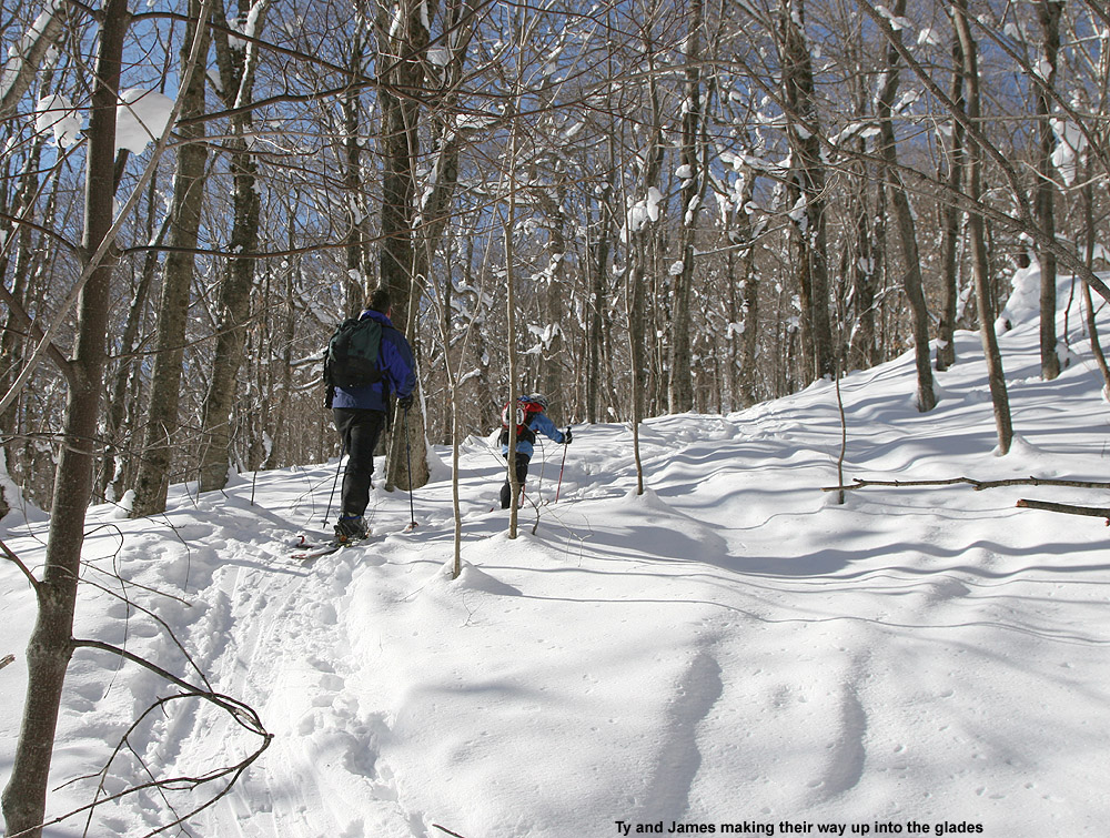
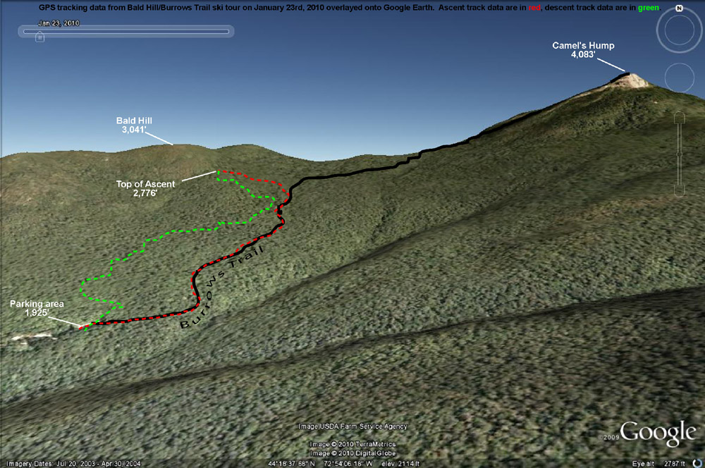
With the snowfall thoughts in mind, the plan was to do some skiing off the west side of the Camel’s Hump/Mt. Ethan Allen area. Unfortunately, on Friday we found out that Tom had tweaked his knee and ankle at soccer, so the ski group for the day was going to be just James, Ty, and myself. We met up with James in Huntington Center a bit after 9:00 A.M., and decided on an initial plan of heading up the Forest City Trail to do some skiing on the lower flanks of Mt. Ethan Allen (3,674’), the next prominent peak south of Camel’s Hump. We headed up Camel’s Hump Road, finding that the access to the Forest City trailhead was going to be difficult because the road there wasn’t plowed in the winter. There was a little room along the snowbank to potentially park a couple of cars, but a more important factor in our case was the added distance to get to the trailhead. Ty’s backcountry range is not that great yet, so we weren’t looking for a big approach. There was the option to connect over to the Forest City Trail from the Burrows Trailhead area, but we decided to just do something simple off the Burrows Trail. James had commented to me earlier that there was going to be a temperature inversion in effect, and that was indeed what we saw on our ascent of Camel’s Hump Road. From down in Huntington Center (690’) where the temperature was somewhere in the middle single digits, the temperature was up around 10-11 F at the trailhead parking area (~1,900’). The lot was about half full, and while we geared up, we could see that several parties of people were heading out for hikes on snowshoes.
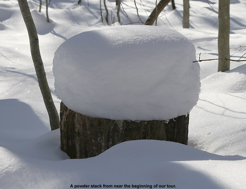
Some of the powder stacked along the Burrows Trail
Starting up on the Burrows Trail, I checked the snowpack and found a couple inches of fluff on top of a generally thin crust, atop a lot more settled powder. A few of the lower elevation stream crossings on the trail were open with small gaps, and that represented a bit of a challenge for Ty, but he managed well. We didn’t have any lofty goals in mind other than getting in a little skiing, since our ultimate destination would likely be affected by Ty’s mood and stamina. Our pace was pretty slow with Ty taking his time, but it was an easy go, and everyone’s skins were working well on the packed trail. There were lots of dogs, lots of people on snowshoes (including a bigger group that seemed to be from the UVM Outing Club), and we also saw a party of about four skiers that passed us on their way up the trail. One of the more interesting sights was a woman coming down trail at breakneck speed on a sled that looked like a booster seat. We made sure to move out of her way, but she seemed to be very conscious of the uphill traffic and stopped easily. James inquired about how her sled worked, and she demonstrated that for braking, you just lean back. I know that people like to use those Mad River Rocket-style sleds on the trail and elsewhere, but this was the first time I’d seen what this woman had.
Ty and James ascend Bald Hill.
Up to about the 2,300’ elevation mark the surrounding vegetation was on the brushy side, but above that point it began to thin out and the potential for skiable lines looked a little better. Off to our right, we could see some open, moderate angle slopes across the big gully that had begun to parallel the trail, and off to the left we could see the more obvious lines that steepened on the way up to Bald Hill (3,041’). Ty had some good bursts of skinning speed when we kept him motivated, but as inquiries about how far we were going and when we would get to ski became more frequent, we decided it was time to think about our descent route. Heading off to the left for the lower slopes of Bald Hill was going to make things easiest for getting back to the trailhead for Ty, so a bit above 2,500’ when we hit one of the skin tracks breaking off the Burrows Trail and going in that direction, we took it. The change of scene was enough to keep Ty motivated for a little bit longer, since we were able to tell him that we’d be able to descend soon.
We headed up into the glades a little farther, reaching an elevation of about 2,700’ before Ty seemed to be getting just a bit too antsy. There were plenty of good lines available with untracked snow, but we could see that taking them would mean dropping right back down to the Burrows Trail almost immediately. So, we continued to contour westward to get something that might drop a little more directly to the trailhead. We could only traverse so far though, since Ty knew we were close to skiing and his inquiries started up again. When we finally called it on the traverse, James and I skinned up a little farther to catch a nice looking line, while Ty waited just below us.
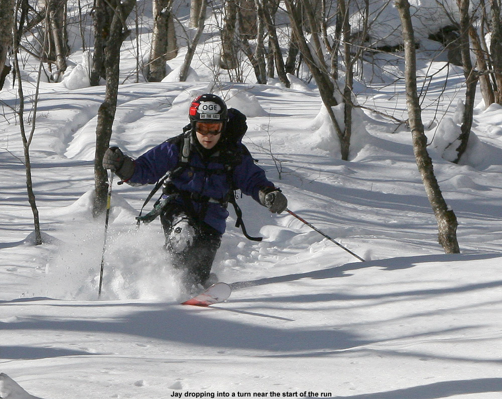
Jay enjoys some turns in the beautiful powder out there on Bald Hill.
The skiing was good, and definitely worth the hike, but certainly not perfect or quite up to what I’d found off the Monroe Trail the previous weekend. The combination of settling and the thin breakable crust in some spots made things tricky at times, but it was all soft and fun. Ty stuck with just alpine turns, but had a lot of fun catching air and working on his jumping technique. Our extra traversing had bought us a little longer descent, but we still dropped back to the Burrows Trail pretty quickly. Instead of trying to ski on and near the trail, we took a traverse out to the west with the aim of eventually dropping back down to the parking lot to finish our run. I used the GPS for route finding, and as is often the case, James went by his natural sense of direction. The biggest issue with the traverse was that like on the Burrows Trail itself, a few streams were still open from the previous warm weather. They weren’t too hard to cross since there were still snow bridges around, but Ty’s smaller skis definitely set him at a disadvantage for spanning some gaps. We helped him across when needed. Even with the aid of the GPS, I overshot the parking area by about 100 feet or so and had to swing back during my final descent, while James nailed it right on.
The GPS tracking data from today’s ski tour plotted on Google Earth
Looking back at the resort trails today as I head up into the alpine
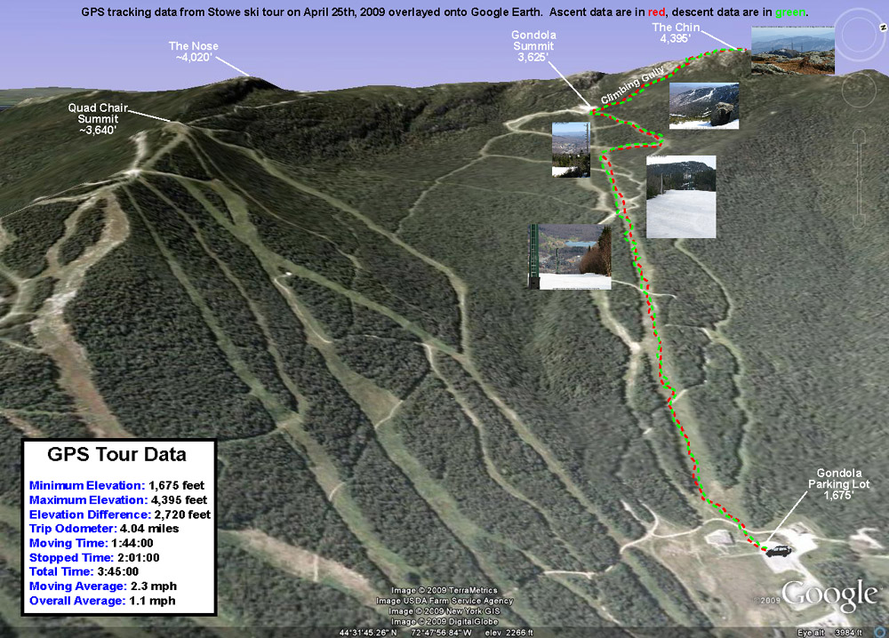
The boys were more interested in planting flowers with Mom on Saturday than skiing, so unfortunately I couldn’t interest them in going out for some turns. This meant that I was on a solo outing, but the upside was that I’d be able to do a much bigger tour than I would have been able to with Ty, or especially with Dylan. The skies were clear and blue all Saturday morning on what was likely our warmest day of the spring up to that point. The temperature was already around 80 F when I pulled into Stowe’s Midway lot (~1,700’) in the early afternoon, and with the forecast for temperatures in that range, I hadn’t been too optimistic about the snow quality. My major goal was to at least get in a good workout, so I was willing to negotiate some sloppy snow on the descent if that was the way it had to be.
Snow was available right from the Midway Lodge elevation, with just a couple hundred feet of fairly flat walking on grass to get on it from the parking lot. I was immediately surprised when I got on the snow and found that it wasn’t sloppy at all; it was all corn with just the top inch or so loosened up. That’s the sort of corn that seems to provide some of the easiest turns, so I was immediately enthusiastic about the potential for a quality descent. There wasn’t much of a breeze in the lower elevations, but the snow helped keep the air temperature a bit cooler and the ascent was very enjoyable. For ascent attire I’d gone about as minimally as I felt comfortable doing, with a short sleeve polypropylene T-shirt and my ski pants with the side zippers fully open, and that worked out to be a comfortable setup for the temperature. I hadn’t made a non-powder ascent on skins in a while, and I was quickly reminded how the lightness of Telemark gear allows you to simply fly up the slopes. Before I knew it I was up at the Cliff House (3,625’) and feeling great, so I decided to keep going up into the alpine.
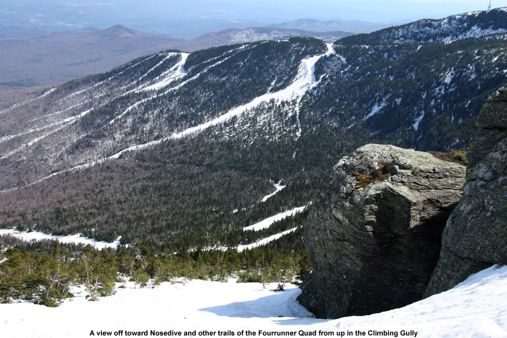
I set my skis onto my pack and hit the climbing gully. There was a bit of rotten snow in spots, and as I didn’t immediately find a boot ladder, I had visions of an inefficient, sloppy climb with lots of post-holing. I’d already post-holed a few times in the outskirts of the gully (it only took one of those to remind me to get my ski pants zipped up at least halfway) but fortunately, about 50 feet up the climbing gully I found a boot ladder made by some nice big feet. That made the going fairly smooth, and the views of the Green and White Mountains continued to improve with each step. Near the top of the gully, I ran into a guy about to descend. He had spent an overnight or two on the mountain, and said that he’d been amazed to find fresh powder on Friday morning when he’d started skiing. It sounds like along with Thursday morning, Friday morning had also been good in the higher elevations with regard to fresh snow. The downside of the fresh snow was that conditions in the alpine were still a bit sloppy. The new snow had not yet cycled to corn in the highest elevations, so it just wasn’t going to provide an optimal surface. By the time I departed from my conversation in the gully, I was moments from the Mansfield ridge line. Up on the ridge I enjoyed the new westerly views of the Champlain Valley and Adirondacks, and decided to stop in at the top of The Chin (4,395’) since I was so close. There was a small group of college students enjoying the popular leeward side of the summit, and there was a pleasant breeze of probably 15 MPH or so. The high temperature for the day at the Mt. Mansfield Stake came in at 67 F, so I suspect that the summit maximum temperature was probably close to that. Getting an April day like that at the top of The Chin is certainly a treat.
For my descent, I wasn’t able to ski right in the summit or the West Chin area due to lack of snow, but I was able to ski down the gully where the Long Trail drops away from The Chin as it heads south. It was quite a perspective to see the snow create a flat surface through the gully, when in the off season it’s a 10-foot deep chasm containing the hiking trail. I had to remove my skis to descend the very top of the climbing gully, but below that point one could keep them on continuously. As expected, the new snow up high that hadn’t fully cycled to corn wasn’t as nice as the corn snow on the bottom 2,000’, but I actually had some fun turns in the climbing gully, and it let me work on Telemark turns in steeper, tighter confines. I still had to make some alpine turns and throw in some side slipping up there since some areas were just so tight, but overall the gully allowed a good mix of styles. The crème de la crème of snow surfaces for the day was probably the top half of the Gondolier descent. There must have been very little traffic up there because most of the snow surface was just a smooth layer of ripe corn. The lower half of Gondolier still had nice corn snow, but the surface wasn’t as smooth as the top half of trail. Perhaps the lower elevations had experienced more melting that started forming aberrations in the surface. Based on my GPS data, it looks like my descent was 2,720’, not quite what you can get for vertical in the winter when you head all the way back down to Route 108, but still a decent run. There were still about 7 feet of snow at the stake on Saturday, and even though that level has dropped some with the recent warmth we’ve had, skiing should available on Mt. Mansfield for a while.
A Google Earth/GPS map of today’s ski tour up to the Chin of Mt. Mansfield – Click the image for a full size map
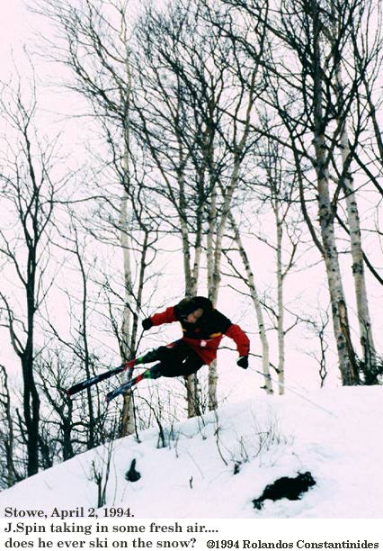
Catching some air today at Stowe while Rolandos runs the camera
Today I spent the day skiing with Rolandos and Chris at Stowe – we had soft spring snow and hit some of the old favorites like Lord, and of course Hayride with those great bumps. Rolandos took some photographs with his camera, and it was great having the chance to be out with a skilled photographer possessing a real SLR camera. Rolandos scanned his negatives (or something along those lines) and created some digital images that I’ve added to this report.


