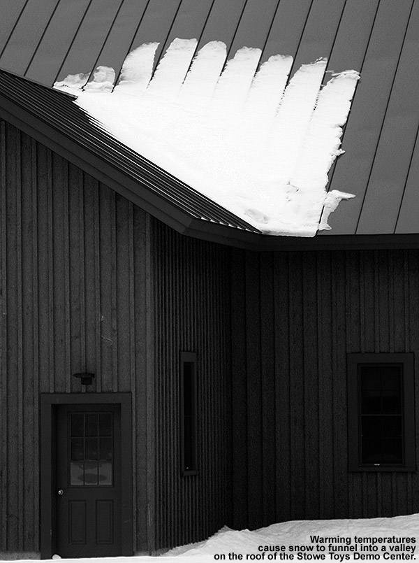
Stick season can be a tough time to get out for exercise; there are often those cold, dreary days in the 30s or 40s F that don’t really inspire one to jump on the bike or into the kayak. Instead of hitting the trail, it’s much easier to hunker down at home in the warmth. Fortunately in Northern New England, when the weather reaches such a cold and dreary level, there’s often fresh snow falling in the mountains. That wasn’t the case this weekend though, as the current storm affecting that area is fairly warm, and the precipitation isn’t expected to change over to snow until tomorrow night. With the weather at hand, there wasn’t much calling us out onto the slopes. However, since Stowe prepared some of their terrain and ran the Fourrunner Quad for season’s pass appreciation day yesterday, it meant that there would be some rather unutilized groomed snow out there today. That realization hadn’t even occurred to me until late morning when I was thinking about what we might do to get in some outdoor activity today. I brought up the idea to E and the boys, and once the house and homework were generally in order, we decided that we could spend a couple of hours getting in some turns.
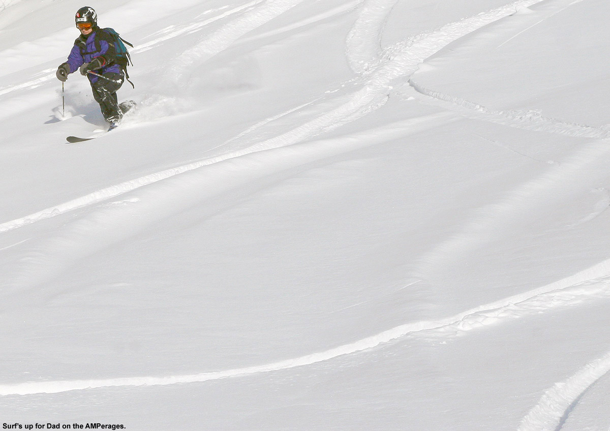
“What I encountered was an inch or two of dense powder, it had seen some contamination by manmade snow, but that was enough to keep me riding on a smooth, supportive base.”
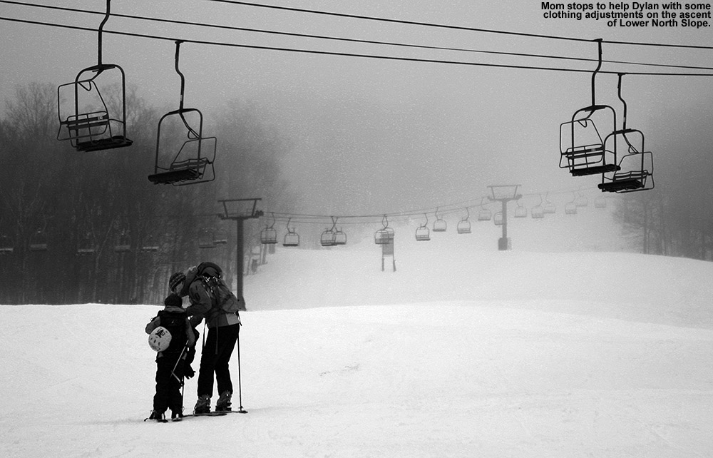
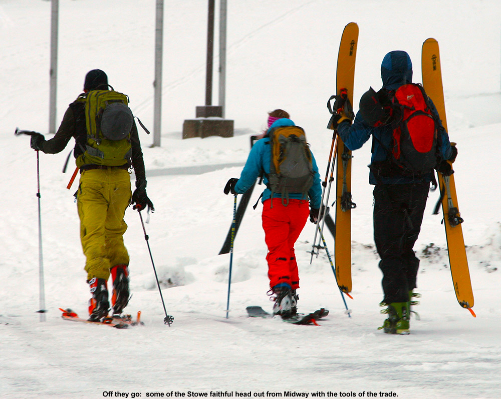
We headed out in the mid afternoon under cloudy skies and occasional spits of drizzle, finding temperatures in the mid 40s F in the mountain valleys. We’ve only got a couple patches of snow left at the house, and in general there’s really nothing to speak of for snow up the Mountain Road until you get around the 900-1,000 foot elevation. From there the snow builds until there’s decent cover at 1,200’ and above, but south-facing areas exposed to heavy sun are still partially melted out even up at those elevations. We parked at 1,500’ near the Mansfield Base Lodge, where, we saw a few other vehicles and one skier just starting to skin up toward the quad on their ascent. Temperatures were in the low 40s F and the snowpack looked quite respectable – there was a consistent covering of several inches or more, and the consolidated snow was only slightly softened by the above freezing temperatures. In fact, we were thinking it would have been nicer if it was softened even more with regard to making turns.
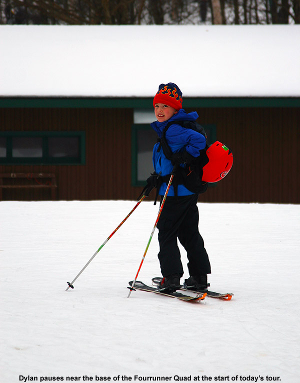
A sign of today’s warmthDylan out on the snow today
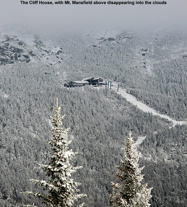
We skinned up to the base of the Fourrunner Quad and continued past it toward the bottom of Lower North Slope, which with its prodigious manmade snow was the obvious route that every other skier we saw was taking. There was really no skin track, nor was there need for one – the whole expanse of the slope was essentially a smooth mass of consolidated snow that you could walk through like a giant field of white. We spread out and often walked side by side, enjoying what was definitely a leisurely pace. We really didn’t have any goal for the ascent, we figured we’d just go as far as the quality of the snow and the availability of daylight suggested. We stopped for a quick break at the intersection with Crossover (~1,850’) – we were just starting to enter the clouds at that point and combined with the late afternoon light, visibility was very low. We continued on up Crossover to where it met Standard at around 2,000’ and decided to end the ascent there.
“I’ve been quite impressed with their sushi so far, and it was great again tonight.”
For the descent, we began our way down Crossover, finding the snow pretty much as we expected based on what we’d felt beneath our feet on the ascent and heard from the descents of other skiers. It was soft enough to get a nice bite with the edges, but not as soft as you’d really like it to be for spring skiing. Temperatures around 40 F just weren’t enough to get it to soften that far. Crossover has some irregularities in the surface from snowcat, snowmobile, and skier traffic, so it also wasn’t as smooth as if it had been freshly groomed. The snow had enough issues that it had me looking elsewhere, such as the natural snow on Lower Lord that I’d seen on my way up. As Powderfreak mentioned with regard to yesterday’s opening at the resort, even some natural terrain trails were open, and there was clearly enough coverage even down below the 2,000’ level to make that a reality. I decided to make a few turns down Lower Lord, just to check it out, and then I could shuffle back up to Crossover if the skiing was horrible. Well, those first few turns had me sold. What I encountered was an inch or two of dense powder, it had seen some contamination by manmade snow, but that was enough to keep me riding on a smooth, supportive base. I told E and the boys to dive in and check it out, and if they didn’t like it we could head back up. Everyone enjoyed the snow – the only thing was the after a few more turns, the extra density that had been imparted by the manmade snow disappeared. The powder became much wetter and the base less supportive. We made a few more turns before deciding to cut through the trees onto Lower North Slope because it was just going to be too difficult for the boys to be trying Telemark turns in that challenging snow. Snow depths were certainly sufficient on the natural terrain; Dylan and I both checked the snow depths and found 7-10 inches in that 1,800-2,000’ elevation range. It was a tough call switching over to the groomed snow though, I could have gone either way personally – it was a choice between slightly too firm manmade, or slightly too soft natural snow. Lower North Slope ended up delivering some decent turns, and the boys got to make some Telemark turns on the more supportive surfaces. There was still plenty of uneven terrain since the snow hadn’t seen a re-grooming, but it was smooth enough for some good flowing turns.
Rain was starting to pick up as we returned to the car, and we quickly put the skis on the rack and tossed the rest of the gear in the back to get out of the rain and on our way. With the temperature around 40 F, it was certainly a raw rain as well. This outing was decent, but we’re certainly watching the forecast for the potential to get back into the powder by next weekend. The computer models suggest that the possibility of snow is out there, but they’re definitely not all in agreement yet so we’ll have to wait a few more cycles to see where things settle out. More cold air is definitely on the horizon though.
We stopped off to grab some take-out from Sushi Yoshi on the Mountain Road, they’ve only been there a few months, and this will be their first ski season. While ordering, I was talking to the hostess about the anticipation of the business during the ski season, and she said that they’re actually planning on running their own shuttle bus to allow people to go to and from the restaurant without having to worry about driving. It will be interesting to see how people like that feature, but in any event, I expect business will be picking up greatly in the next few weeks as visitors start to hit the resort. I’ve been quite impressed with their sushi so far, and it was great again tonight. We also got some of their hot dishes tonight as well, and they were fine, although they didn’t seem to stand out the way the sushi has. They also have hibachi-style dining options as well, so one of these days we’ll have to bring the boys and try that out. I’ll definitely be getting more sushi though whenever I go, from what I’ve experienced I think they’ll be getting plenty of patronage from sushi lovers this ski season.
You had to hunt a bit more today due to skier traffic and wind, but great powder is still out there.
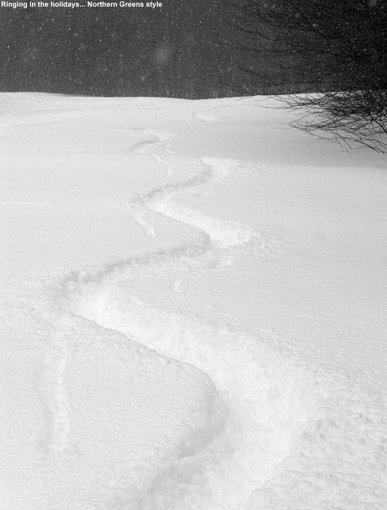
When it comes to the Northern Greens, it can be hard to know when a snowstorm is complete. Just when you think an event is finally winding down, these mountains can cause it to fire back up and dump another foot of snow. In this case, that’s just what happened. After Tuesday’s great outing on Mt. Mansfield, I figured there wouldn’t be enough additional snow to lure me back out on the slopes too quickly, but I was wrong. While people anticipated a couple of additional inches to fall as the event finished up, a foot of additional snow was reported at Jay Peak, and another half foot at Stowe. There was already plenty of base in place, so after hearing first hand reports from some of our students at UVM about the great skiing brought about by the additional snow in the mountains, and seeing pictures like the one Powderfreak posted from Jay Peak, I heard the slopes calling again.
A view on the Liftline ascent
So I headed out to Stowe for another early morning session, and the temperature was definitely warmer this morning than what I encountered on Tuesday – it was even a bit above freezing in some of the mountain valleys, and around the freezing mark at the Midway Lot (~1,600’). The snow was still dry, but what was immediately evident was that the snow conditions aren’t as pristine now as they were a couple of days ago. The decrease in quality I saw was due to a combination of skier traffic and wind, and in those areas that were affected, the fresh fluff that fell yesterday was beaten down into something much denser. Since the snow had that wind crust in areas, it was a little harder to efficiently probe the snowpack depths on my ascent, but in general nothing has really melted over the past couple of days, and the snow depths with respect to elevation seemed fairly similar to the numbers provided in Tuesday’s report. I went with yet another ascent route today, and ascended the skin track up Midway that continued on to Liftline. This is the route that I had used last November, and it was a little frustrating at that point because I was using skins cut to Atomic RT-86s that were a bit too narrow for my AMPerages. I’ve got full-width skins now, so the issues from that day were resolved, but I was still slipping a bit up part of the Liftline skin track, and I’ve decided that it’s due to the fact that people have put in a skin track that’s just a little too steep. People should incorporate a few more switchbacks on the Liftline route to get a more reasonable grade on the ascent; it typically ends up being more efficient in the long run.
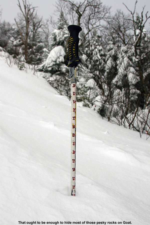
In any event, while I’d seen some decent, soft looking snow on Midway, Liftline was exposed and was riddled with wind crust. I watched a group of three guys descending the trail, and it was obvious from how little they were sinking into the snow that the wind crust was indeed substantial. One of the three appeared to be an excellent Telemark skier, and at one point he went head over heels dealing with the challenging snow. Seeing that spectacle, I decided to go for something more protected, and Goat came to mind. Some wind had still gotten in there, but it was far more protected than Liftline. I’m more leery about trails like Goat in the early season, since it holds a lot of interesting rocks, but as I probed along the skier’s left of the trail, I found a solid two feet of snow. That definitely looked sufficient for skiing the trail.
“The farther down I went on the trail, the more protected and fluffier the snow was…”
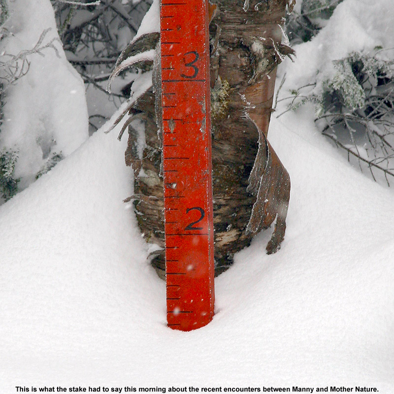
With still a little trickiness to the snow, and the narrow, bumpy, rough and tumble nature of Goat, I found myself making plenty of alpine turns at first. I’ve got to say, I’d love to have another pair of these AMPerages mounted alpine, because they were a heck of a lot of fun in that snow – they created such a stable platform. The farther down I went on the trail, the more protected and fluffier the snow was, and I finished off with some beautifully soft turns on Lower National, which had seen a lot less traffic than the bottom of Lower Nosedive. Coverage remains quite good, and I even passed through some woods on my traverse to Lower National that could easily have been skied. That’s certainly consistent with the snow depth at the Mt. Mansfield stake hovering close to that 24” mark.
It was definitely warming up when I left, and I felt a little stickiness in the snow in the very lowest elevations (last couple hundred feet), so I’d say the snow down there will lose some of its fluffiness. There’s still plenty of snow out there for those that want to make turns, but you just have to pick the lesser used areas now if you want untracked snow. It also may mean going a bit higher to get into the winter snow, depending on how high the freezing line crept upwards today.
“If someone had asked me about ski choice for today, I would have just said to take your fattest skis, whether they’re brand new or not.”
The front came through overnight as expected, dropping about an inch of snow down at our house, and more in the higher elevations. Things seemed to have come together, so I decided to head out to Stowe for an early ski tour. Temperatures were generally in the mid 20s F as I traveled through the mountain valleys, and there were no issues with the roads until I started climbing up toward the mountain around 1,000’. Above that elevation I found enough packed ice and snow that it warranted a bit more cautious driving. At the Midway Parking Lot (1,600’), the temperature was 20 F and there was light snow falling. There was the usual crowd of early morning skiers heading out and returning from the slopes, and I suspected it would be easy to find a nicely established skin track on any of the typical routes.
Heading out from Midway for turns
Since our last outings a couple of weeks ago focused on the Gondola side of Mansfield, I decided to mix it up this time and took the well established skin track that headed up Nosedive. It was well packed, and made all the sweeter by the fact that for much of the ascent there was a parallel boot pack available for anyone hiking without skins. The snowpack increased very quickly with elevation on the bottom half of the mountain, and I found the following depths during my ascent:
1,600’: 4-6”
2,000’: 8-10”
2,500’+: 12-18”
Above ~2,500’, I was essentially well into the deep stuff, and the gains in snow depth weren’t huge beyond that. Of course, when you’re already talking 12-18” of snow with plenty of substance to it, the lack of additional increases isn’t a big deal. At the top of Nosedive, I continued my ascent up the Toll Road for a few more minutes to check in on the depth of the snowpack at the fabled Mt. Mansfield Stake. At ~3,700’, the stake showed at least 17” of snow, and I generally found 18-19” there when I probed on the edge of the Toll Road itself, so indeed the snow depth up there was right around a foot and a half.
It’s really a nice sheltered area up along the road by the stake, and since the snow wasn’t perturbed by wind, you could definitely get a sense for where the snow stood with respect to quality. Indeed that quality was looking very good. As one would expect with the latest round of fluff, the snowpack was right side up with the lightest snow on top, and it was primed and ready for some turns. Big, dendritic flakes were falling while I was there switching over for the descent, and I stood and savored the moment for a while before pushing off down the road. I crossed over toward the Fourrunner Quad, and the summit area was awash in manmade snow. I didn’t even see that many guns going up there – I think the resort has already been able to hammer that area with manmade snow with the cold temperatures we’ve had.
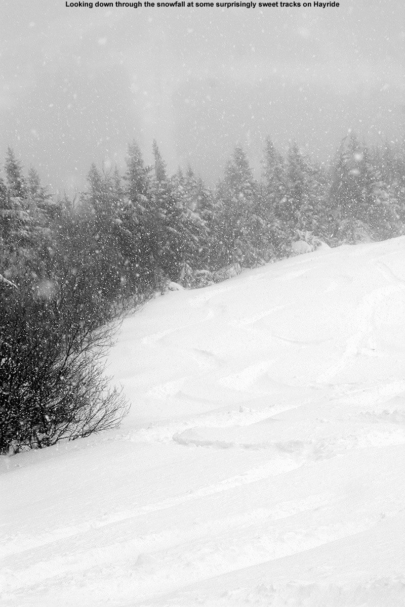
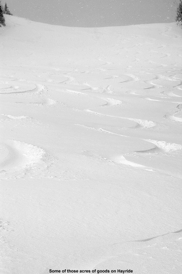
Hayride today
So now I’m left with just one more thing to discuss, the pièce de résistance for the day… the descent. While ascending Nosedive, it was clear that there had been a huge bolus of snow dropped above 2,500’, so coverage wasn’t going to be an issue. Temperatures were certainly not in question either, since it must have been somewhere in the teens F. That left the aspects of snow density and the effects of the wind, and based on the turns I was seeing by people descending Nosedive, it looked like the skiing was going to be fine, even if not sublime. But, I suspected I could do better. There had definitely been some wind on Nosedive that appeared to have packed out the snow a bit. With that in mind, I decided to roll the dice and check out another descent route – Hayride. I’d had good luck on Hayride back on April 10th of last year, when Mt. Mansfield got laced with over two feet of dense, resurfacing snow. It was actually the challenge of that snow on Telemark gear that was one of the final nails in the coffin in convincing me to finally get some fat, rockered skis for Telemark use. I could already tell that today’s snow conditions were nothing like what I encountered on that April outing – with the new fluff, this snow was notably drier. I hadn’t actually thought that it would be anywhere near the quality of what we had last November on the 30th, but after a few turns on Hayride I found that it was certainly in the same league. And indeed we’re talking quite the league – Hayride was sheltered from the wind, so turn after turn after turn I was able to push hard on the deep snow. It gave way, let you sink in, but pushed back with just enough force to keep you from getting to the ground. With 115 mm underfoot and judicious line choice, I think I touched down twice on something other than snow on the entire descent. Just like last November, the AMPerages were totally in their element, letting me play around in the deep snow on a remarkably stable platform. They helped out immensely with fore-aft balance, and I can recall some specific instances where I was saved from what easily could have been a face plant. If someone had asked me about ski choice for today, I would have just said to take your fattest skis, whether they’re brand new or not. Today, a combination of fat skis with the available snow would be plenty to keep you safely above most underlying obstacles. You’d probably end up having a heck of a lot of fun as well.
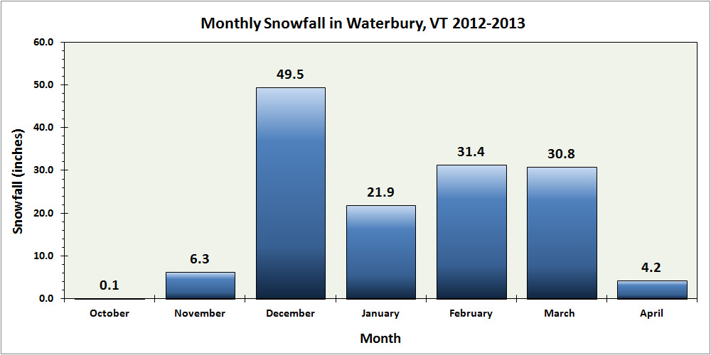
Waterbury snowfall for the 2012-2013 season – broken down by month
The last snowstorm of the 2012-2013 winter season extended all the way out to Memorial Day weekend to produce some great late season skiing, but now that we’re well into summer and all the snow has melted, we can look back at how the winter went down at our location in Vermont’s Winooski Valley. The main focus in the seasonal analysis below is on snowfall, but snowpack and temperatures will be discussed as well. In this post I’ve hit on some of the highlights that came out of the data, and attached our various plots and graphs, but to get to the full data set, you can use the following link:
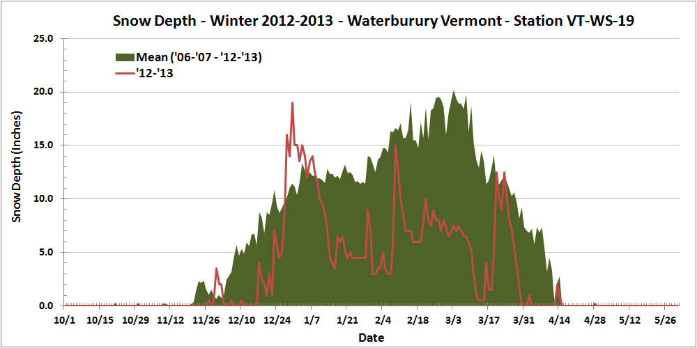
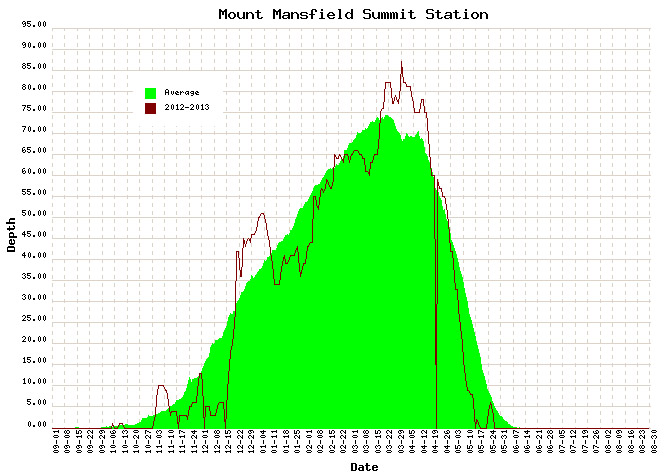
Thankfully, this past season’s snowfall (144.2″) marked a notable increase over the previous season (115.3″), but the total snowfall for 2012-2013 was still less than 90% of average, so that’s not likely to lift the season into the category of “great” winters. In addition, the amount of snow on the ground at the house last season didn’t help to improve the winter’s standing. Using the value of snow depth days as an integrative way of representing the season’s snowpack, one finds the 2012-2013 winter season producing a value of 729 inch-days, less than half the average value, and right down there in the basement with the well below average 2011-2012 season (688 inch-days). And, if the overall snowpack depth hadn’t already undermined any chances of redemption to an average level, the 2012-2013 snowpack secured the season’s ignominy by reaching the lowest value we’ve seen in January and February (3.0″), and coming within a hair’s breadth of melting out in the area around our measurement stake at a record early date in mid March:
This past season’s rather meager snowpack at our location in Waterbury (red line) relative to average (green shading)
Often, each month of the winter/snowfall season has its own unique flavor with respect to the weather, so one method I like to use to get a feel for the winter is to look at it on a month-by-month basis. Again, the focus below is on snowfall at our location, but snowpack is also considered, as well as mountain snowfall/snowpack and the associated effect on the local skiing. I’ll have a separate 2012-2013 ski season summary coming up, so I’ve kept the ski discussion minimal here in anticipation of a more thorough discussion in that report. The month’s total snowfall is listed at the start of each section below for reference:
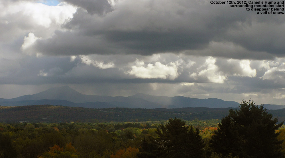
Snowfall: 0.1″ – October snowfall isn’t reliable enough down at our elevation to be factored much into the seasonal assessment, but this October was on the weak side, with just a tenth of an inch of snow, vs. the mean of roughly an inch. Regardless of this, there was still enough for the needs of companies like https://divisionkangaroof.com/areas-served/gainesville/ with the weight of the snow causing damage to some roofs. One small feather in the cap of 2012-2013 is the fact that the first accumulating snow fell on October 12th, which beats out 2010-2011’s October 15th snowfall by three days, and now represents the earliest measurable snowfall I’ve recorded here at the house since I started monitoring the weather in 2006.
Snowfall: 6.3″ – November snowfall came in just a bit below average this past season, so certainly not remarkable, but notable in that it was probably about as average a November as we’ve seen. November has typically been feast or famine when it comes to snow. We actually had a total of five snowstorms in November, but a small to moderate storm of 4.4″ at the end of the month contributed the bulk of the monthly total as well as some of the first great skiing of the season in the mountains.
Snowfall: 49.5″ – December held the first lengthy, redeeming snowfall period of 2012-2013. Although the first half of the month was extremely poor on snowfall (just 2.2″ of snow at the house), from the 16th of December onward, temperatures got cold and snow came in for a dramatic change; close to 50″ of snow fell on us in the second half of the month, and as a whole the month actually wound up several inches above average. Those in homes with faulty or no heating in place are likely to struggle with the crushing cold at this time of year which is why it’s so important to conduct regular maintenance on heaters so you’re not left to suffer over winter. Reaching out to the likes of these professionals could help with this – siriuspac.com/heating-repair-service/. A problem left unaddressed could snowball into substantial damage and become more costly to repair over time so it’s well worth acting on it as early as possible. We received our second (15.5″) and fourth (11.7″) largest storms of the season during that stretch, right near Christmas and just a few days apart, so needless to say, the snow was there to set quite the holiday mood in the valleys and up above on the slopes.
Snowfall: 21.9″ – January continued that good, snowy weather pattern in its first week, albeit to a lesser degree than December, but unfortunately that modest first week ultimately wound up representing roughly half of the month’s snowfall. The second week featured a couple of substantial thaws with no measurable snow, and in fact we received no accumulating snow at all for the period between January 7th and 16th, a very long stretch for the mountainous areas of Northern Vermont during the winter. The third week of January offered just a few small systems, and the fourth week was arctic cold with minimal snow. The final week attempted to recoup the losses with a modest half foot storm, but it was too little too late – the month ended with just 21.9″ of snow, by far the lowest January in my records. The combination of very low snowfall and two January thaws was very deleterious to the valley snowpack – after coming down from the depths achieved in December, the snowpack depth at our location never even reached 10 inches again during the month, and got as low as 3.0 inches. That is ridiculously close to losing the winter snowpack in January, definitely the closest we’ve come based on my records since 2006.
Snowfall: 31.4″ – February was again below average in snowfall, partly due to the continuation of the dry arctic pattern in the first week, and it wound up missing the mark for the lowest February in my data set by less than an inch. Although that persistent dry pattern didn’t make for a very snowy first half of the month, our third largest storm of the season (12.6″) hit in the second week. It was still a rather modest storm, but at least it did break that one foot mark for accumulation at the house. By the end of the third week of February, the snow depth at the Mt. Mansfield stake actually poked above average for the first time in about a month and a half – but it was only by a couple of inches, and it quickly went back below average as the snowpack sat there essentially stagnant for an entire month. On February 21st, the snowpack was at 65″, and roughly a month later on March 18th, it was still at 65″, without any major consolidation of more than a few inches. That’s stagnant. Our snowpack at the house languished similarly, never even getting above 10 inches of depth during that stretch – and that’s a time of year when it is usually building to its peak of the season. The carryover of the low snowpack from January also set the lowest mark (3.0″) for snowpack that we’ve ever seen in February.
Snowfall: 4.2″ – April was even a couple inches below average for snowfall, but temperatures stayed cool enough to keep the winter season rolling along, and that’s what really helped make the period wintrier. We didn’t have any notable April snow accumulations down at our elevation, just a couple of small ones on the 2nd, and again on the 12th – 13th, but the mountains continued to get fresh snow right into mid month to keep surfaces in great form and the Mt. Mansfield snowpack robust.
Snowfall: 0.0″ – There was no accumulating May snowfall down at the house this season, but that’s not too much of knock on the Month, because not getting snow in May is more the norm than actually getting snow. The mountains did get that beautiful Memorial Day weekend storm though, and the late season powder skiing was mighty fine. Although I can’t factor that directly into the analysis for the valley, it was quite cold in the valleys at the end of the month, and close to even snowing there.
There were a couple of other interesting notes with respect to snowfall this season:
1) Storm frequency and average storm size: Despite coming in below average for snowfall, the 2012-2013 season offered up a healthy 51 accumulating snowstorms, almost up there with the 53 storms we received in 2007-2008. Of course, to come in below average for snowfall with that many storms indicates that the average snowfall per storm was down, and indeed it was. At 2.8″/storm, 2012-2013 ranks down there with 2011-2012 (2.6″/storm), the only odd seasons out compared to the more typical seasons up near 4″/storm. For whatever reason, this season’s average came in on the low side. This is presumably due in part to many of the everyday events being on the small side, but also due to the lack of bigger storms, which is covered in point #2 below.
2) Storms with double-digit snowfall: It’s certainly an arbitrary and subtle distinction, but after looking through my data, I noticed an interesting trend with respect to each season’s largest storms for our location. In my season summaries, I always make a list of the top five storms of the season, and when the season seems to have gone well, all of those top five storms have been in the double digits for snowfall. In fact, the “best” seasons thus far have been able to surpass that five-storm threshold. For reference, here’s the top five list for this season, with the links to the detailed web pages for each storm:
Indeed, if we look at the number of storms with double-digit snowfall by the seasons, we see an obvious trend. With the number of double-digit snowfall storms listed in parentheses after the season, one notes those “good” seasons – 2007-2008 (6), 2008-2009 (7), 2010-2011 (7) seemed to find a way to exceed five double-digit storms, whereas the poorer snowfall seasons – 2006-2007 (4), 2009-2010 (2), 2011-2012 (3), 2012-2013 (4) just didn’t. Surely the law of averages comes into play here to some degree – seasons with patterns producing lots of snow likely have a greater chance of getting a big storm in here, but that’s not a given. It’s also very suspicious that those seasons that come in sort of in that middling ground like 2006-2007 and our season of interest for this summary, 2012-2013, fall just short of making the cut. I suspect this trend may be more intact in a location like ours because of the relatively high number of storms and snowfall, and upslope snow (which was on the low side this season) as an extra protection against huge snowfall variance, but this is going to be an interesting trend to follow into the future as a gauge of snowfall seasons.
In sum, while snowfall was certainly a bit below average, and snowpack was well below average, I’d still give the season a reasonable grade. If C is average, I’d go with a C- for 2012-2013, just a bit off from making the average. Were snowpack a more significant factor in my winter preferences, one could argue for going a bit lower, but at least minimal snowpack was maintained throughout the entirety of the winter to keep everything white. Overall it could have been a lot worse, and with the amount of snowfall we did get, it’s hard to drop the season into the D range, which, based solely on snowfall and snowpack at the house, is where I’d put a season like 2011-2012.
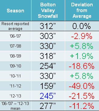
Snowfall: Compared to the snowfall-deficient 2011-2012 Ski Season, the 2012-2013 Ski Season was certainly a step up, but it was still generally below average for snowfall in the mountains of Northern Vermont. It was Bolton Valley that seemed to fare the worst of the northern resorts along the spine of the Green Mountains, perhaps due to their west slope location and this season’s dearth of upslope snow; they reported just 78.5% of their average snowfall. Heading northward, Stowe and Smugg’s fared a bit better at around 85% of average, and Jay Peak reported roughly average snowfall. Down at our house in the Winooski Valley, snowfall was 88.6% of average, so not too shabby by most accounts, but a bit below the mean like some of the local mountains. These past two seasons have actually been the first pair delivering back-to-back below average snowfall in our area since we started keeping track in 2006. Those numbers can be seen in both our Waterbury Winter Weather Summary Table, and the table of Bolton Valley annual snowfall below; this past season’s snowfall is highlighted in blue:
Low snowfall last winter meant back to back seasons with below average snowfall at Bolton Valley.
Snowpack: Aside from the spikes associated with a couple of early season storms, the mountain snowpack was below average going into mid December. That changed quickly though, with the onset of all that new snow during the second half of the month. The above average snowpack achieved during the holidays didn’t actually stay that way during January’s warmth and lack of storms. After consolidation, the snowpack generally trundled along at or below average through February’s continuation of relatively low snowfall. From mid February to mid March, the snowpack sat there essentially stagnant for an entire month; to wit, on February 21st, the snowpack was at 65”, and roughly a month later on March 18th, it was still at 65”, without any notable consolidation of more than a few inches. The late season stretch from mid March to mid April represented a nice rebound for the mountains however, with some quick gains from the big Northern New England March storm getting it above average, and the snow depth staying at least modestly above during the period.
Two periods stood out this past season for above average snowfall: The holiday period and mid-March through the end of April.
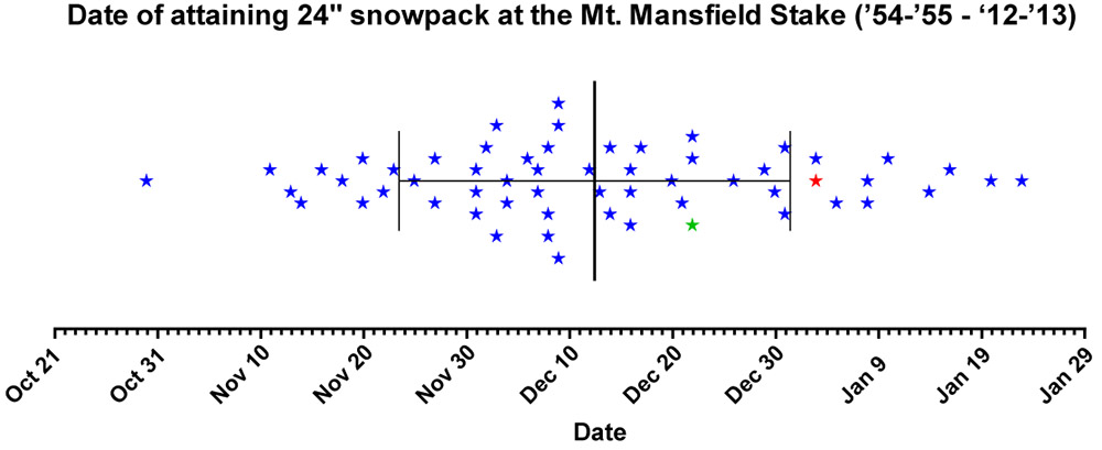
Tree Skiing: One metric used as a rough guide for the start of off piste skiing in the Northern Green Mountains is the point at which the snow depth reaches 24” at the Mt. Mansfield stake. For those unfamiliar with how this metric was established, it’s described in some detail in the 2011-2012 ski season summary. With the incorporation of this season’s data, the mean date remains at December 12th ± 19 days, with an average depth at the stake of 25.9 ± 2.7 inches. After the very slow start in 2011-2012, in which the 24” depth wasn’t attained until January 3rd (more than a standard deviation later than the mean), this past season was notably earlier. The plot below shows the date at which 24” was obtained for each season since 1954, with 2011-2012 shown in red, and 2012-2013 shown in green:
Each star marks the date of attaining a snow depth of 24 inches at the Mt. Mansfield stake, covering all years since 1954. Although still a bit later than average, reaching a depth of 24 inches at the stake this past season (green star – Dec 22) occurred much earlier than the previous season (red star – Jan 3). The mean date for attaining a depth of 24″ is marked by the large vertical bar in the center of the plot, and the smaller bars indicate the range of one standard deviation above and below that mean.
This past season, the date (December 22nd, Depth=28”, Green Star) was still later than average due in part to the slow first half of December, but unlike last season it was well within the 1 S.D. bars (thin vertical black lines). Note that the 24” mark is being used as an indicator of when the first forays into appropriate off piste/tree skiing terrain typically start in the Central and Northern Greens. In terms of empirical tree skiing observations, personal experience again lends some support to the use of 24” mark this season, as we began venturing into the trees the very next day on December 23rd at Bolton Valley. It should be noted though, that while the 24” mark was attained on December 22nd this season, the 40” mark was attained the very next day on December 23rd. The 40-inch rule (i.e. reaching a depth of 40” at the stake), is used as an indicator of when most off piste/tree skiing around here is ready to go. Although I haven’t looked into the data, this season has got to represent one of the quickest ascents from 24” to 40” – it’s interesting to note however that after rising to 42” of depth on December 23rd and 24th, the snowpack settled back to 36” for a couple of days before rebounding to 45” on the 27th.
Snow Quality: As an monitor of snow quality for the season, the chronological list of our ski outings has once again been compiled, with those days in which we were skiing powder indicated by a P, and those days in which powder skiing wasn’t available indicated by an X. The availability of powder suggests a fairly high level of snow quality, and the absence of powder generally indicates that temperatures rose above freezing at all elevations. Each listing below represents a link to the full report where images and more information from the outing can be obtained. Outings with an X may still be providing decent skiing such as wet snow, corn, etc. (or else skiing was typically avoided) but aside from the spring period, there’s going to be a price to pay in terms of snow quality associated with these episodes when temperatures eventually cool back down. The pattern of snow conditions in the Northern Green Mountains was fairly typical this past winter, with those days lacking powder skiing showing up in three distinct periods: 1) the early season with its usual temperature fluctuations, up through mid December before the weather pattern changed and the cold weather stabilized, 2) a thaw period in mid January, and 3) the period starting in mid March where spring weather began to make inroads. However, with the way the weather patterns this past spring continued to provide cool temperatures and snowfall, powder skiing generally dominated until mid April. Having analyzed the skiing in this way for the past three seasons, a surprising level of consistency is noted, with an overall average of close to four out of five days providing powder, despite notable differences in the demeanor of these recent ski seasons. The 2010-2011 season, which was above average in snowfall, provided powder on 78% of outings, the 2011-2012 season, which was well below average in many ways, revealed the same 78%, and most recently the 2012-2013 season, which was slightly below average in this area, produced a very similar 77% of outings with powder. The percentages don’t take into account differences in the number of outings each season, but with all three seasons falling into the range of 50 to 60 ski outings, differences in the sample sizes aren’t huge. The list of categorized ski outings with links to their full reports follows below:
The detailed month-by-month synopsis of the season is next:
October: It wasn’t an especially snowy October to kick off the season; we had five rounds of snow in the mountains, and the third one even dropped accumulations to the lowest mountain valleys, but none of the storms were huge dumps, and we had just a tenth of an inch of snowfall down at the house for the month. October’s first snowstorm started up on the 7th, with snowfall being reported at the top of the Mt. Mansfield Toll Road in the afternoon, and by the next morning Powderfreak sent along his picture of 4” of accumulation at the top of the Stowe Gondola. I also got a shot of Mt. Mansfield later in the day with its first accumulation of the season. It didn’t seem like quite enough snow to tempt me out to ski, but the FIS boys hit the snow and provided a thorough report of the turns. The second storm delivered some accumulation on the 11th, with a snow line up around the 3,000’ level and less than an inch of snow found up on Mt. Mansfield. The third storm was the one that finally touched the lower valleys with some minimal accumulations, but in terms of mountain accumulations, I don’t think it was anything more than junkboarding material. The 4th (on the 14th of the month) and 5th (on the 16th of the month) storms of October also appeared to be pretty minimal and generally flew under the radar in terms of discussion. So while it wasn’t a great October for natural snow skiing (with nothing like the back-to-back larger storms at the end of October during the previous season), some folks made some turns and there were several smaller rounds of snow to keep the peaks white.
April: Despite the somewhat slow increases in the snowpack during the heart of the winter, the gains made during the latter half of March meant that the snowpack was at least modestly above average heading into April, and it quickly reached a peak of 87 inches at the Mt. Mansfield Stake when the first storm of the month dropped a foot of snow at Stowe on April 2nd. I was up at Bolton Valley that day for a ski tour, and I got to witness some impressive snowfall rates as the storm crashed into the higher elevations. The alpine terrain above tree line on Mt. Mansfield was in good shape, consistently providing excellent outings during that first part of the month. Cool temperatures with additional snow meant that the snowpack stayed at an above average level right through the month, and another storm on the 12th saw Ty and I enjoying close to a foot of dense powder out in the Bypass Chutes at Stowe on the 13th. The skiing gradually transitioned to full on spring conditions after that weekend as the active pattern waned, and an impressively long stretch of clear weather moved in and stuck around well into May.
May: For most of May, there wasn’t much to talk about in terms of new powder, especially with the extended period of incredibly clear weather that carried over from the end of April and lasted a fortnight, finally ending on the 10th of the month. There was some mighty fine spring skiing right through that period with all the sun and warm weather, even if it did cause the snowpack to decrease a bit faster than it otherwise might have. The tranquil period of warm weather allowed the Mt. Washington Auto Road to open on the 10th of the month as well (definitely on the early side), but since unsettled weather had just returned at that point, we didn’t get to make our spring pilgrimage to the snowfields until the 18th. To really cap the month off well, Northern New England and the Adirondacks were rewarded with a Nor’easter over Memorial Day Weekend, which delivered roughly 3 feet of powder to Whiteface and nearly 2 feet to Mt. Mansfield. Excellent powder turns were made while the valleys were almost fully leafed out for the spring. We didn’t actually head out for any June turns beyond that, but the skiing over Memorial Day Weekend had been so good that it hardly mattered – it was just a few short months until the snows of fall would be returning.
So what about the overall feel for the quality of the ski season in Northern Vermont? Well, much like the snowfall numbers suggest, it feels like it came in a bit below average, even if not horribly so. The mountain snowpack (as gauged by what was seen at the stake on Mt. Mansfield) had its ups and downs, and on balance it probably gets rated in a similar manner to what the slightly subpar snowfall would suggest. Being frequent Bolton Valley skiers and living down below the mountain in the Winooski Valley, our perspective might be skewed a bit downward with the resort receiving just 78.5% of their average snowfall. Having the north miss out somewhat on a couple of big regional storms, while watching a horrid valley snowpack (see the 2012-2013 Winter Weather Summary for details) that kept ski routes to the lower valley bottoms essentially off the table, certainly didn’t win the season any extra points. It seems that 2012-2013 ultimately sits in the lower half of ski seasons and won’t be remembered as anything epic, but it also appeared to hold onto a decent level of powder availability (77%) based on our experiences, and that means there was still a pretty decent amount of good skiing. The fact that even the poor 2011-2012 Ski Season was able to hold onto a powder percentage in that range is also reassuring in that regard, suggesting that there is indeed a certainly level of reliability that can be expected in these seasons where snowfall/snowpack is below average.
I awoke this morning to our coldest temperatures of the season – we bottomed out at 7.2 F and there was no doubt that the snow was going to be light and dry. Since the snow had shut off by roughly midnight, there had been plenty of time to clean up the roads, and the trip over to Stowe was quick. There were a good 20+ vehicles present as I parked in the Mansfield lot, and although it was still fairly dark, I could see a few skiers making their way up the slope leading to the trails. They seemed to be heading off in the direction of Nosedive, so I opted to head that way and hopefully make use of an established skin track.
“I’ve often wondered if it was worth going the slightly narrower route on skins to reduce weight and enhance glide. After today’s experience, I can tell you to forget about it for typical alpine ascents.”
The track headed up Lower National through a few lower elevation snow guns, and the areas of firm, manmade snow quickly made me aware that my ascension setup wasn’t going to be perfect. I was using my AMPerages (139-115-123) to see how they fared in the powder, but since I don’t have skins for them yet, I was using my RT-86 skins (127-86-113). That width differential left a good deal of base exposed, and on occasion I had to use a heaping helping of arm strength with my poles to avoid slipping. Although I’ve always cut my skins to the full width of my skis, I’ve often wondered if it was worth going the slightly narrower route on skins to reduce weight and enhance glide. After today’s experience, I can tell you to forget about it for typical alpine ascents. Unless you’re going to be touring on very low angle terrain, it’s just not worth it based on what I experienced today – any benefit from the weight/glide could easily be lost by the constant slipping. Thank goodness the skin track didn’t have any post holes in it this morning or it would have been a huge pain to hold traction. Up through Lower National I was getting by reasonably well with the occasional small slip of my skins, but the challenge wasn’t quite over. After reaching the top of Lower National, the skin track shot up Midway, which has quite a steep pitch, and maintaining skin traction became a lot harder. The pitch eased a bit as the track made its way onto Nosedive, but by the time I’d reached the Liftline/National junction, time was getting short and I was more than happy avoid any more slipping. It was time for a descent.
I’d been checking on snow depth during my ascent, but due to all the snow this week, there was a lot of unconsolidated stuff under the current storm’s bounty and it was difficult to assess just what came down overnight. I’d been getting measurements of roughly a foot or more since I’d started at the base area (~1,500’), but when I stuck my measurement pole into the snow at that ~2,800’ mark, I got an overall depth of 18 inches. Combined with what I was seeing around me from other skiers (check out the pictures from adk and from Powderfreak at the American Weather Forum), who were having little if any issues touching down on obstacles below the snow, the potential turns were looking really good. National is quite steep and while it wouldn’t typically be my first choice for early season skiing, Mother Nature has really been dishing out the snow on Stowe this week. It looked ready and I was about to test it out.
“These new fat, rockered skis are absolutely the real deal. I continued to bound my way down the steep slope, just amazed at how easy the turns were.”
I switched to descent mode and decided to see what the AMPerages could do. I dropped in for the first few turns, tentatively, still wondering in the back of my mind if I was going to hit something below, but it was immediately obvious that there was plenty of snow. The powder was light and dry, and I quickly found myself just giddy with how well the AMPerages performed. This was my first time on such fat, rockered skis, and although I figured that there might be some modest, incremental increase in ease of powder skiing over my regular Telemark setup, it was far more than that. These new fat, rockered skis are absolutely the real deal. I continued to bound my way down the steep slope, just amazed at how easy the turns were. At the bottom of National I decided to avoid heading back down toward the snow guns where I’d ascended, and instead took Houghton’s over toward the Lookout Double. It was very quiet over there, since it was well away from any snow guns, and I finished off my run turning my way through fluffy silence. It’s not even December 1st and there’s not just passable, but really good natural snow skiing from top to bottom on Mt. Mansfield, so indeed that’s a great end to November on the slopes.
A peaceful Lookout this morning
Sure today featured the best snow I’ve encountered this season, but I can already tell that the powder skiing is going to be just that much more fun this season with the new boards in the quiver. I’ve now tested the AMPerages in some legitimate Champlain Powder™ – they handled the fluff with aplomb and they are clearly NVT worthy in that regard. Presumably the whole season won’t be just a fluff fest, so I’m also eager to see how they handle thicker snow and crud, but we’ll have time for that.
Blue skies today with a combination of natural and manmade snow coating the trees at the summit of Stowe’s Fourrunner Quad
I was in Morrisville today, so on the way home to Waterbury I stopped in at Stowe to make some turns. From the Stowe Village area, the view is quite nice with all the trails covered in white from the snow at the beginning of the week. Even at midday, the temperature was just a bit above freezing at the base (~1,500’) and the resort was cranking out snow from top to bottom. The bulk of the snowmaking was taking place on the main routes in the Lord/North Slope area, although snow was also being blow over on the lower slopes of Spruce Peak in the same places that we’d seen it on Sunday. To avoid the roar of the guns, I decided to make my ascent up Nosedive. Hiking was in order at the start of the ascent, since natural snow doesn’t appear until roughly the 1,800’ elevation. The air was generally calm and the temperatures pleasantly cool as I hiked, and finally when I reached the 3,000’ elevation it seemed that the snowpack was sufficiently deep and consistent enough to strap on the skis and start skinning. There were a couple of descent tracks from people who had skied the upper parts of Nosedive, and while the snow was actually quite nice with some powder and sugary surface hoar, you’d certainly want to use your rock skis based on the coverage. I topped out at the Fourrunner Quad summit area, and switched over for the descent on the plateau above Nosedive away from the snow guns. Estimates of the natural snow depth at various elevations on the ascent are as follows:
“The descent featured all sorts
of conditions, such as bottomless
manmade snow, sticky manmade sludge,
refrozen moonscape, and thankfully,
some areas of packed powder and
partially groomed manmade snow.”
The descent featured all sorts of conditions, such as bottomless manmade snow, sticky manmade sludge, refrozen moonscape, and thankfully, some areas of packed powder and partially groomed manmade snow. I started the descent on Upper Lord, and that was where I found the bottomless manmade that had recently been blown. After my experience with the snow on my November 4th tour, I have to say that I find that unconsolidated manmade stuff even more horrific to ski than Sierra Cement or Cascade Concrete, at least on Telemark gear. The turns often feel like an accident waiting to happen as you glide across the top and then suddenly cut into the paste with random frequency as you pressure the turn. Fortunately that ended by the time I reached the top of the Lookout Double. Snow was still being made, but the guns weren’t as densely packed and you could get around so that you were riding on older snow. Those middle elevations offered some of the best turns, with some nice packed powder to be found. The manmade snow that had had some time to dry out and/or had been packed by other traffic skied quite nicely. I did get into trouble in one spot where a gun was blowing fresh snow that turned out to be on the wet side – as soon as I stopped, several inches of it glommed onto the bottom of my skis and I had to slowly work it off while I got moving. I did my best to avoid any of the snow being blown by the lower mountain guns after that point, but it seemed like that one was just especially bad because of the mixture it was putting out. On the bottom half of the mountain there were still some areas of nice snow, but also refrozen and slick areas where one had to be careful to avoid a sliding out. At the bottom of my run, the guns were blowing in the North Slope Terrain Park, and I was dreading the thought of what the snow would be like down at that elevation. I watched a snow cat head right up through the gut of the trail, so I waited for him to make it above me in order to stay out of his way. That turned out to be very beneficial, because the best snow was actually in the track that had been churned up by the treads. It hadn’t been fully smoothed out, but by breaking up the top skin of the manmade snowpack, it produced some really nice packed powder. Those turns were actually great as I made my way back and forth in the swatch of the snowcat, and it gives me confidence that once Stowe’s snow is appropriately groomed, it’s going to ski quite nicely.
Today at the summit of the Fourrunner Quad
So, I definitely found some nice turns out there today. Today’s skiing scores well above what was available when I went out for a tour back on November 4th, but it wasn’t quite up to the consistency we found in the corn snow on Sunday’s outing, so today will fall in the middle of the pack for this November’s turns. It looks like we’re going to continue with this stretch of generally clear weather into next week, so while we can’t expect much natural snow during that time, at least the temperatures are such that plenty of snowmaking can take place.
The past week has seen some excellent cold temperatures for November snowmaking in the Northeastern U.S., and Stowe took full advantage, running close to 200 snow guns at times. I witnessed some of the high elevation guns being fired up when I was out on the mountain last Sunday, but since that point it’s been an all out assault reaching all the way down to the base. The resort did such a thorough job covering the slopes that they were able to go ahead with an early opening for seasons pass holders yesterday. The conditions looked fantastic based on Powderfreak’s pictures from the day, but just as exciting was the fact that the lifts wouldn’t be running today, opening up the chance for earned turns. The forecast called for sun and temperatures in the 50s F, so it looked like we’d have some nice soft snow for carving.
We had house guests over in the morning, and then stopped by the Nordic Barn to pick up some new poles and Telemark boots for Ty, so it was mid afternoon before we got to the mountain. This meant that we were already in the shadow of mighty Mansfield as we began our ascent, but the sun was still shining brightly on the east wall of the valley. There’s still a good deal of natural snow around on Mt. Mansfield, with a half foot of snow at the stake as of this evening, but the snowmaking terrain in the North Slope area was the obvious choice in terms of coverage. The ascent was very easy, since the surface was predominantly dense, manmade snow, which had consolidated with today’s warm temperatures and become spring-like. We saw a couple of people heading up just ahead of us, but we appeared to be the last group ascending for the day.
The boys had a good ascent in terms of their energy levels, and we got to enjoy numerous views of the Spruce Peak area as we made our way up out of the base elevations. It turns out that Stowe even turned on some of their snowmaking firepower on the sunny slopes of Spruce, and we could see large expanses of white that had been laid down in the Easy Street and Slalom Hill areas. We topped out on North Slope in the area of the Lord junction, with dusk dictating that we just had to descend. Beneath the darkening sky, we descended with the trails to ourselves toward the glowing lights of the Stowe Mountain Lodge. We had just enough light to see the terrain, so it made for one of those surreal on-slope experiences. Even at the late hour, the snow remained soft, and it supported great carving thanks to the warm air that’s moving into the region. Dylan was the hero of the descent, actually finding a tail clip from Ty’s skin that had been lost on the way up. It was amazing that he was able to find the small piece of metal it in such low light, but he’s going to be inheriting those skis soon once we get Ty’s new ones mounted, so perhaps it was destiny.
After getting in some skiing last weekend, and now this one, November 2012 is turning out much more typical than the previous couple we’ve seen. Both of those featured above average temperatures, so I only got out for one day in November 2011, and not even a single day on November 2010. I’m definitely enjoying the return to normalcy this year, and although we’ve got a couple of warm days on tap, snow is already back in the forecast for the mountains and valleys on Tuesday.
I left the house near midday under cloudy skies and a temperature of 39 F, but a few minutes into the drive, the temperature dropped to 37 F in the Waterbury Center area, and snow began to fall. It snowed lightly all the way to the mountain, and accumulations began to appear just as I hit the resort base at ~1,500’ in elevation. The temperature had really dropped as I ascended the last stretch to the resort, and as I parked in the Midway lot, the temperature was right around the freezing mark.
Accumulations in the Midway area were generally a trace to an inch, so I stowed my skis on my pack and headed over toward Nosedive to use that standard route of ascent. As I approached the 2,000’ mark, the snow depth became a bit more consistent, generally in the 1”-2” range, and I switched to skins. I was probably a touch early on putting on my skins since I encountered a few more spots of mud, but that’s what rock skins are for, and it made for a lot less slipping than hiking in my boots. The precipitation that had been snow at the start of my ascent turned into more of a freezing mist as I headed into the clouds around 3,000’. Up around 3,600’ at the Stone Hut it was windy, well below freezing, and quite chaotic with Stowe’s snow gun firing off what seemed like a 21 gun salute. I sheltered behind the hut to keep out of the wind and the roar of the snow guns as I switched to descent mode and had a much needed snack. The wind made for plenty of drifting during my ascent, but I’d sum up the snow depths with respect to elevation as follows:
I’d only encountered a couple of groups descending on Nosedive while on my ascent, but there were plenty of tracks from previous visitors and the snow was quite packed out, so I decided to descend some other terrain off to the south. The combination of wind, freezing mist, low visibility, and manmade snow made for a really challenging descent, especially on my skinny Telemark skis, so I generally just took it easy and stuck to mellow terrain. In general I didn’t find much in the way of decent turns until I got down onto Sunrise below the snowmaking, and pretty quickly after that the snow depth was getting a bit meager. I did manage some nice turns here and there, but eventually it was more gorilla-style survival turns until I finally decided to call it at the elevation of Crossover. I strapped the skis back on my pack and had a nice stroll back to the car. I’d say at this point the skiing isn’t worth putting in a ton of effort, but it’s definitely fun to get out for a few turns if you’re close by. We’ll have to see if anything comes from the Nor’easter that’s expected this week though, because the current snow could serve as a decent base for another round of accumulations.
On our way toward Burlington to run some errands today, we headed up to Bolton Valley in the mid afternoon to get our season’s passes. Temperatures were in the low 40s F at the house, but started to drop pretty quickly as we ascended the Bolton Valley Access Road. The first signs of snow on the ground along the road were just above the Timberline Base in the 1,700’ elevation range, but I also noticed that slushy snow was still present on vehicles in the parking lot of the Timberline Base Lodge (1,500’) even though there was nothing left on the ground there. I suspect that the snow line was a bit lower last night, but I’m not sure quite had far down it reached. Up in the village at 2,100’ it was snowing with temperatures in the low to mid 30s F, and we found about an inch and a half of accumulated snow on the ground/elevated surfaces. It was quite a contrast descending the road and spending the afternoon in the Burlington area, where the temperatures were in the mid 40s F and it was hard to imagine that it was snowing even below 2,000’, the lapse rate actually seemed steeper than usual today. In the Champlain Valley it was often just cloudy with the feeling that precipitation had wound down, but as the afternoon wore on, spits of precipitation and bouts of light rain became more common. At times we’d have bursts of more moderate precipitation and it was nice to know that moisture was still heading to the mountains and falling as snow. Leaving Burlington later in the evening we went from 42 F in Williston to ~37-38 F at the house. There no accumulating snow to report down here as the temperature is sitting around the 37 F mark, but we’ve got light to moderate rain right now and 0.18” of liquid in the rain gauge since it was emptied this morning, so it’s probably still accumulating at elevation. A few pictures are available from our visit to the higher elevations of Vermont today.

 We stopped off to grab some take-out from Sushi Yoshi on the Mountain Road, they’ve only been there a few months, and this will be their first ski season. While ordering, I was talking to the hostess about the anticipation of the business during the ski season, and she said that they’re actually planning on running their own shuttle bus to allow people to go to and from the restaurant without having to worry about driving. It will be interesting to see how people like that feature, but in any event, I expect business will be picking up greatly in the next few weeks as visitors start to hit the resort. I’ve been quite impressed with their sushi so far, and it was great again tonight. We also got some of their hot dishes tonight as well, and they were fine, although they didn’t seem to stand out the way the sushi has. They also have hibachi-style dining options as well, so one of these days we’ll have to bring the boys and try that out. I’ll definitely be getting more sushi though whenever I go, from what I’ve experienced I think they’ll be getting plenty of patronage from sushi lovers this ski season.
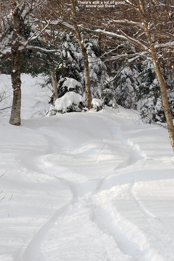


")


