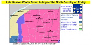
I’ve added the updated advisories and warnings map from the National Weather Service Office in Burlington, but their projected accumulations map looks similar to yesterday, so I’ll just refer to the one that was already posted earlier in the blog. In his forecast from this morning, Roger Hill suggested the potential for 1 to 2 feet in the Green Mountains, with 6 to 10 or 8 to 14 for some valley locations and the potential for school closures. Looking at the winter storm warnings from BTV, it seems that the biggest totals are more south of here, although as is often the case, if upslope gets into the picture later in the storm cycle, the Northern Greens seem to do pretty well. The current point forecast for our location in the Winooski Valley at ~500’ suggests 5 to 10 inches through tomorrow, and then additional snow Friday night, Saturday, and Saturday night. We’ll have to see how this system goes around here, but similar to what we saw in 2007-2008, we would be closing in on the 200-inch mark for seasonal snowfall at our location if we get a decent dump.
