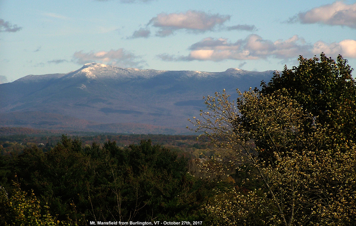
Mt. Mansfield and its latest coating of snow seen from Burlington
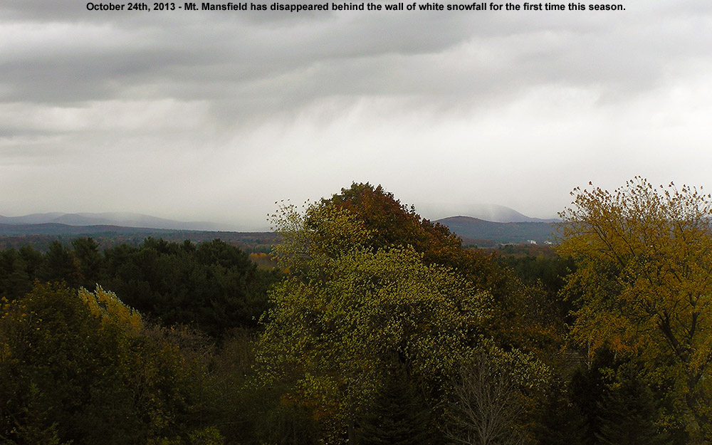
We’ve had plenty of pleasantly benign weather days this month, but yesterday was one of those raw October days that really speak to the seasonal progression. Temperatures in the valleys even stayed well down in the 40s F, and a storm passing through the area brought bouts of heavy rain that made walking around outside a rather rough experience. I wasn’t sure if this storm was actually cold enough to bring in some snow to the area, but sure enough, Powderfreak was already posting snowy images from Mansfield this morning and letting us know that the snow level was down to 3,000 feet. Once the clouds began to break away from the mountains in the afternoon I was able to snap an image from my office of the new white near the peak of Mansfield behind some of the colorful foliage still hanging on in the Champlain Valley. We’ve got a potent storm coming into the area Sunday that is expected to bring a lot of wind and rain, and next week there’s the chance for a bit more snow in the area as we get some cooler temperature and a flow that could bring moisture over from the Great Lakes.
The appearance of snow in the higher elevations here in the Northeastern U.S. is definitely becoming more frequent as we approach November, and we’ve had two more rounds of Vermont snow in the past week. The first took place on the 26th as a low pressure system made its way across the area, with fairly high snow levels around 3,000′. Then the peaks were whitened again as of this morning with more snow. This latest event was also fairly warm, with snow levels up above 3,000′, but cold air is expected to come in as we enter November, dropping snow levels all the way to the lower mountain valleys. None of these systems have delivered snow amounts worthy of much more than junkboarding, but it’s been nice to have white in the peaks along with October’s foliage. It won’t be long before the snowfall amounts should increase and start to stick around for the winter.
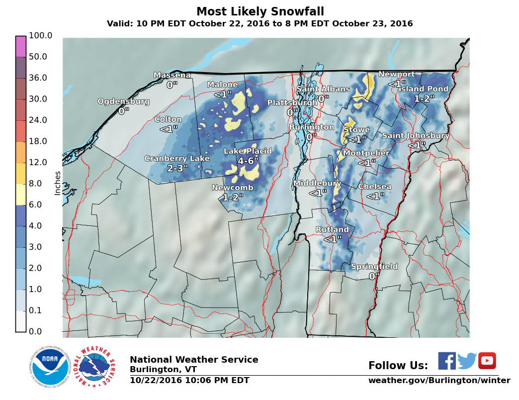
“We just documented our first frozen precipitation and accumulation of the season down here at 500’ in the valley. It started pouring out a few minutes ago as one of those bursts of precipitation came through in the northwest flow – you can see those yellow 28 db returns that disappear as the pulse of moisture barrels into the mountains:
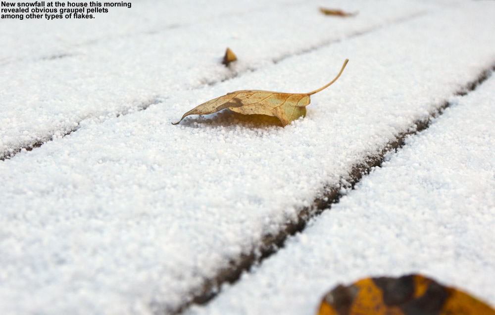
As a pulse of heavier moisture ran into the mountains today, it dropped snow all the way down to our house in the Winooski Valley
Hearing the racket of the heavy precipitation outside, I decided to check out on the back deck because I know how these things sometimes go – indeed there was frozen precipitation among the rain, in the form of sleet and other dense granules that can typically make it down through the warmer layers of the atmosphere. I don’t even have my snowboard set up yet, but our picnic table out back sufficed to catch the accumulation. Seasonally, the timing of this event was right on track, with the mean for the first trace of snow here at Oct 20th from nine seasons of data. The event has actually brought the median value for that first trace of frozen down from Oct 21st to be right in line with that mean date of the 20th, and the S.D. dropped from seven days to six, so it’s helped to tighten up the data spread. The accumulation might have actually reached the 0.1” threshold for an official accumulation, but I was definitely caught off guard and by the time I grabbed my ruler and made measurements, all the accumulation was below that 0.1” mark so it will have to go down as a trace.”
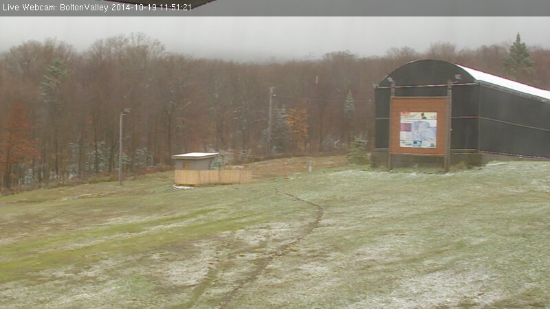
We’ve been hearing mentions of snow in the recent weather forecasts, mostly about how we’re getting close to those temperatures where the mountains can start to see flakes, and today I saw the first reports of snow up in the higher elevations. One of the engineers manning the broadcast equipment up on Mt. Mansfield snapped a picture of some of the flakes falling to document the first Vermont snow of the season. It’s not too surprising, with Mt. Mansfield close to the freezing mark this morning along the ridge line. A bit higher up, the summit of Mt. Washington in New Hampshire is sub freezing at this point. It’s October now, and although it looks like we’ll have plenty of nice weather coming over the next week, it’s the time of year when the mountains can start getting snow at any time, so we’ll be on the lookout for upcoming snow chances.
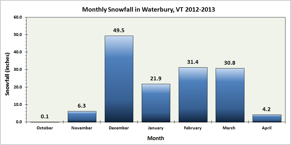
Waterbury snowfall for the 2012-2013 season – broken down by month
The last snowstorm of the 2012-2013 winter season extended all the way out to Memorial Day weekend to produce some great late season skiing, but now that we’re well into summer and all the snow has melted, we can look back at how the winter went down at our location in Vermont’s Winooski Valley. The main focus in the seasonal analysis below is on snowfall, but snowpack and temperatures will be discussed as well. In this post I’ve hit on some of the highlights that came out of the data, and attached our various plots and graphs, but to get to the full data set, you can use the following link:
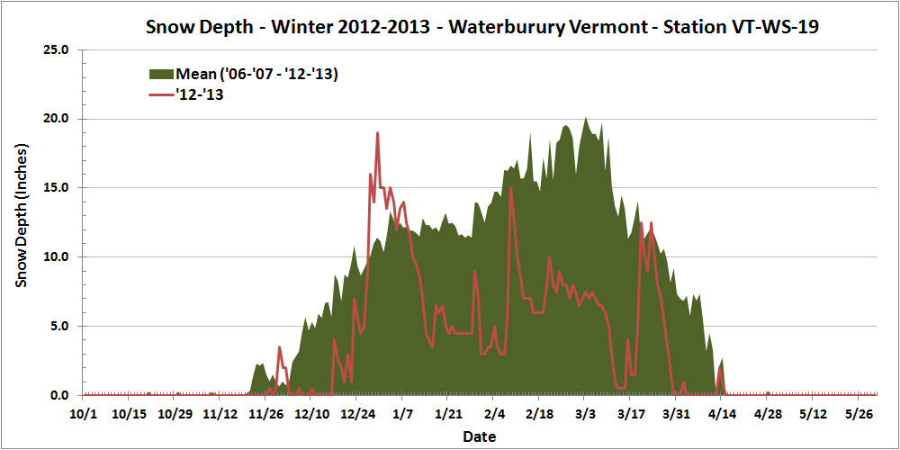
Thankfully, this past season’s snowfall (144.2″) marked a notable increase over the previous season (115.3″), but the total snowfall for 2012-2013 was still less than 90% of average, so that’s not likely to lift the season into the category of “great” winters. In addition, the amount of snow on the ground at the house last season didn’t help to improve the winter’s standing. Using the value of snow depth days as an integrative way of representing the season’s snowpack, one finds the 2012-2013 winter season producing a value of 729 inch-days, less than half the average value, and right down there in the basement with the well below average 2011-2012 season (688 inch-days). And, if the overall snowpack depth hadn’t already undermined any chances of redemption to an average level, the 2012-2013 snowpack secured the season’s ignominy by reaching the lowest value we’ve seen in January and February (3.0″), and coming within a hair’s breadth of melting out in the area around our measurement stake at a record early date in mid March:
This past season’s rather meager snowpack at our location in Waterbury (red line) relative to average (green shading)
Often, each month of the winter/snowfall season has its own unique flavor with respect to the weather, so one method I like to use to get a feel for the winter is to look at it on a month-by-month basis. Again, the focus below is on snowfall at our location, but snowpack is also considered, as well as mountain snowfall/snowpack and the associated effect on the local skiing. I’ll have a separate 2012-2013 ski season summary coming up, so I’ve kept the ski discussion minimal here in anticipation of a more thorough discussion in that report. The month’s total snowfall is listed at the start of each section below for reference:
Snowfall: 0.1″ – October snowfall isn’t reliable enough down at our elevation to be factored much into the seasonal assessment, but this October was on the weak side, with just a tenth of an inch of snow, vs. the mean of roughly an inch. Regardless of this, there was still enough for the needs of companies like https://divisionkangaroof.com/areas-served/gainesville/ with the weight of the snow causing damage to some roofs. One small feather in the cap of 2012-2013 is the fact that the first accumulating snow fell on October 12th, which beats out 2010-2011’s October 15th snowfall by three days, and now represents the earliest measurable snowfall I’ve recorded here at the house since I started monitoring the weather in 2006.
Snowfall: 6.3″ – November snowfall came in just a bit below average this past season, so certainly not remarkable, but notable in that it was probably about as average a November as we’ve seen. November has typically been feast or famine when it comes to snow. We actually had a total of five snowstorms in November, but a small to moderate storm of 4.4″ at the end of the month contributed the bulk of the monthly total as well as some of the first great skiing of the season in the mountains.
Snowfall: 49.5″ – December held the first lengthy, redeeming snowfall period of 2012-2013. Although the first half of the month was extremely poor on snowfall (just 2.2″ of snow at the house), from the 16th of December onward, temperatures got cold and snow came in for a dramatic change; close to 50″ of snow fell on us in the second half of the month, and as a whole the month actually wound up several inches above average. Those in homes with faulty or no heating in place are likely to struggle with the crushing cold at this time of year which is why it’s so important to conduct regular maintenance on heaters so you’re not left to suffer over winter. Reaching out to the likes of these professionals could help with this – siriuspac.com/heating-repair-service/. A problem left unaddressed could snowball into substantial damage and become more costly to repair over time so it’s well worth acting on it as early as possible. We received our second (15.5″) and fourth (11.7″) largest storms of the season during that stretch, right near Christmas and just a few days apart, so needless to say, the snow was there to set quite the holiday mood in the valleys and up above on the slopes.
Snowfall: 21.9″ – January continued that good, snowy weather pattern in its first week, albeit to a lesser degree than December, but unfortunately that modest first week ultimately wound up representing roughly half of the month’s snowfall. The second week featured a couple of substantial thaws with no measurable snow, and in fact we received no accumulating snow at all for the period between January 7th and 16th, a very long stretch for the mountainous areas of Northern Vermont during the winter. The third week of January offered just a few small systems, and the fourth week was arctic cold with minimal snow. The final week attempted to recoup the losses with a modest half foot storm, but it was too little too late – the month ended with just 21.9″ of snow, by far the lowest January in my records. The combination of very low snowfall and two January thaws was very deleterious to the valley snowpack – after coming down from the depths achieved in December, the snowpack depth at our location never even reached 10 inches again during the month, and got as low as 3.0 inches. That is ridiculously close to losing the winter snowpack in January, definitely the closest we’ve come based on my records since 2006.
Snowfall: 31.4″ – February was again below average in snowfall, partly due to the continuation of the dry arctic pattern in the first week, and it wound up missing the mark for the lowest February in my data set by less than an inch. Although that persistent dry pattern didn’t make for a very snowy first half of the month, our third largest storm of the season (12.6″) hit in the second week. It was still a rather modest storm, but at least it did break that one foot mark for accumulation at the house. By the end of the third week of February, the snow depth at the Mt. Mansfield stake actually poked above average for the first time in about a month and a half – but it was only by a couple of inches, and it quickly went back below average as the snowpack sat there essentially stagnant for an entire month. On February 21st, the snowpack was at 65″, and roughly a month later on March 18th, it was still at 65″, without any major consolidation of more than a few inches. That’s stagnant. Our snowpack at the house languished similarly, never even getting above 10 inches of depth during that stretch – and that’s a time of year when it is usually building to its peak of the season. The carryover of the low snowpack from January also set the lowest mark (3.0″) for snowpack that we’ve ever seen in February.
Snowfall: 4.2″ – April was even a couple inches below average for snowfall, but temperatures stayed cool enough to keep the winter season rolling along, and that’s what really helped make the period wintrier. We didn’t have any notable April snow accumulations down at our elevation, just a couple of small ones on the 2nd, and again on the 12th – 13th, but the mountains continued to get fresh snow right into mid month to keep surfaces in great form and the Mt. Mansfield snowpack robust.
Snowfall: 0.0″ – There was no accumulating May snowfall down at the house this season, but that’s not too much of knock on the Month, because not getting snow in May is more the norm than actually getting snow. The mountains did get that beautiful Memorial Day weekend storm though, and the late season powder skiing was mighty fine. Although I can’t factor that directly into the analysis for the valley, it was quite cold in the valleys at the end of the month, and close to even snowing there.
There were a couple of other interesting notes with respect to snowfall this season:
1) Storm frequency and average storm size: Despite coming in below average for snowfall, the 2012-2013 season offered up a healthy 51 accumulating snowstorms, almost up there with the 53 storms we received in 2007-2008. Of course, to come in below average for snowfall with that many storms indicates that the average snowfall per storm was down, and indeed it was. At 2.8″/storm, 2012-2013 ranks down there with 2011-2012 (2.6″/storm), the only odd seasons out compared to the more typical seasons up near 4″/storm. For whatever reason, this season’s average came in on the low side. This is presumably due in part to many of the everyday events being on the small side, but also due to the lack of bigger storms, which is covered in point #2 below.
2) Storms with double-digit snowfall: It’s certainly an arbitrary and subtle distinction, but after looking through my data, I noticed an interesting trend with respect to each season’s largest storms for our location. In my season summaries, I always make a list of the top five storms of the season, and when the season seems to have gone well, all of those top five storms have been in the double digits for snowfall. In fact, the “best” seasons thus far have been able to surpass that five-storm threshold. For reference, here’s the top five list for this season, with the links to the detailed web pages for each storm:
Indeed, if we look at the number of storms with double-digit snowfall by the seasons, we see an obvious trend. With the number of double-digit snowfall storms listed in parentheses after the season, one notes those “good” seasons – 2007-2008 (6), 2008-2009 (7), 2010-2011 (7) seemed to find a way to exceed five double-digit storms, whereas the poorer snowfall seasons – 2006-2007 (4), 2009-2010 (2), 2011-2012 (3), 2012-2013 (4) just didn’t. Surely the law of averages comes into play here to some degree – seasons with patterns producing lots of snow likely have a greater chance of getting a big storm in here, but that’s not a given. It’s also very suspicious that those seasons that come in sort of in that middling ground like 2006-2007 and our season of interest for this summary, 2012-2013, fall just short of making the cut. I suspect this trend may be more intact in a location like ours because of the relatively high number of storms and snowfall, and upslope snow (which was on the low side this season) as an extra protection against huge snowfall variance, but this is going to be an interesting trend to follow into the future as a gauge of snowfall seasons.
In sum, while snowfall was certainly a bit below average, and snowpack was well below average, I’d still give the season a reasonable grade. If C is average, I’d go with a C- for 2012-2013, just a bit off from making the average. Were snowpack a more significant factor in my winter preferences, one could argue for going a bit lower, but at least minimal snowpack was maintained throughout the entirety of the winter to keep everything white. Overall it could have been a lot worse, and with the amount of snowfall we did get, it’s hard to drop the season into the D range, which, based solely on snowfall and snowpack at the house, is where I’d put a season like 2011-2012.


