I think it’s been a little while since we’ve had September snows here in the Green Mountains, but the mountains picked up some snow today for their first frozen accumulations of the 2022-2023 winter season.
After a fairly dry summer, the weather pattern has changed over the past few weeks to produce frequent synoptic precipitation, so let’s hope that sticks around we continue into the snow season!
“The data suggest that our first snow of the 2018-2019 winter season from this past Saturday (October 13th) is a few days on the late side of the mean for first accumulating snow (October 10th), but overall quite typical.”
There are a couple of seasons that I couldn’t include in the statistical analysis because of gaps in the data collection early in the co-op site’s history, but there were still 62 seasons in the data set that provided useful information. The data suggest that our first snow of the 2018-2019 winter season from this past Saturday (October 13th) is a few days on the late side of the mean for first accumulating snow (October 10th), but overall quite typical. The full results from the statistical analysis are below, so have a look and think snow!
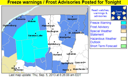
AS OF 454 AM EDT THURSDAY…HIGH PRESSURE WILL CREST OVER THE REGION TONIGHT. GIVEN CLEAR SKIES AND NEALY CALM WINDS WILL ALLOW FOR IDEAL CONDITIONS FOR RADIATIONAL COOLING…WITH TEMPERATURES FALLING INTO THE 30S IN MOST LOCATIONS…WITH SOME TEMPERATURES APPROACHING NEAR RECORD LOWS FOR SEPTEMBER 6TH. EXPECTING TEMPERATURES TO FALL INTO THE UPPER 20S IN THE SHELTERED VALLEYS OF MOST OF THE ADIRONDACKS LATE TONIGHT. THUS…HAVE PUT OUT A FREEZE WARNING FOR THOSE AREAS. ELSEWHERE…HAVE PUT UP A FROST ADVISORY FOR MOST OF THE REMAINDER OF NORTHERN NEW YORK…AS WELL AS NORTH CENTRAL AND NORTHEAST VERMONT FOR PATCHY FROST. NOT EXPECTING ANY FROST OVER THE CHAMPLAIN VALLEY AS LAKE CHAMPLAIN WATER TEMPERATURES STILL IN THE LOW 70S…WHICH WILL KEEP THE VALLEY RELATIVELY WARM WITH MOST TEMPERATURES IN THE UPPER 30S IN THE CHAMPLAIN VALLEY.
Freeze Warnings and Frost Advisories are up throughout much of the state of Vermont tonight.
Parts of the Northeast have had bouts of sub-freezing temperatures since the end of August, but tonight looks like the first widespread occurrence of the season throughout Vermont. We’ve got a frost advisory here in Washington County, but it sounds like some of the colder areas of the state up in the Northeast Kingdom could get down into the middle 20s F, and freeze warnings are in place. It’s certainly time to cover up those gardens in the usual cold spots.
Sub-freezing temperatures are forecast for much of Vermont tonight.
Since it’s the end of August, it probably shouldn’t be that surprising that autumn-like weather is touching the Northeastern U.S., with freezing and sub-freezing temperatures hitting some of the usual cold spots. This has been one of the coldest winters we have had for a long time. For that reason, it is paramount that anyone who has a broken furnace visits https://www.burichvac.com/ in order to find a professional repair service. Equally, you might want to consider having your furnace or central heating system serviced, even if it hasn’t been showing any signs of breaking. These sorts of things should have regular maintenance and just before a very cold spell is the perfect time to check that they are working as they should be. The last thing you’d want is your heating to break as the freezing and sub-freezing temperatures hit. It is simple to find a business who offers these services; citizens of North Dakota, for example, should search for “home heating fargo” (or whatever city they call home) to find an appropriate business. This weather can be very dangerous especially for old people and those that have pre-existing health conditions should take extra care during the winter months. These days often sneak up on us though amidst the typically pleasant weather at the end of summer.
As the afternoon wore on and the clouds dissipated, images from the Mt. Washington web cams began to reveal the white of fresh September rime and snow in the higher elevations
In association with our coldest weather of the season thus far, the mountains of Northern New England saw some snow today. In Vermont, I heard about the frozen precipitation on Mt. Mansfield in a post from Powderfreak at Americanwx.com, and over in the Presidential Range of New Hampshire there were some visible accumulations above the 3,500’ to 4,000’ elevation level. A great video from TheAutoRoad with scenes of snow falling along the Mt. Washington Auto Road was posted, and can be viewed below. Even in the valleys the weather was quite cool today, with highs only in the 50s F, so the look and feel of fall was all around us. Enjoy the video!
Freeze Warnings and Frost Advisories have been posted for the entire state of Vermont.
The National Weather Service office in Burlington has posted a freeze warning for our area, and indeed the entire state of Vermont is under either freeze warnings or frost advisories, so cover up vegetation as necessary. This may also be a good time to look into local furnace maintenance services as you want to be sure your current furnace can meet the demands of this cold weather. Companies like CJS Heating offer such services. Why now? Well, furnaces have to work much harder when the weather is colder and so some may struggle to keep up. The last thing you’d want is for it to stop working whilst temperatures are so low. Though the first frost for valley locations in the Central and Northern Green Mountains does typically happen in September, the average date for the occurrence is toward the end of the month (September 27th for Morrisville and September 30th for Montpelier) so this is a bit on the earlier side. Yesterday in the Northern New England thread at Americanwx.com, Powderfreak posted the chart from the National Weather Service that shows the average dates and ranges for first frost at some of our Vermont climate locations – mid September is in the 10th – 25th percentile. Take a look at that post for more information about average dates of 32 F temperatures around the state.
Low temperatures are going to be down in the 20s F in some locations overnight as the first frosts and freezes hit the North Country of Vermont and New York.
Looking down Stowe's Hayride ski trail at the fresh October snow and brilliant fall foliage
For quite a while, the local weather gurus had been talking about the potential for local snow at the end of September/beginning of October. Yesterday, reports started coming in of white in the mountains, and from UVM I could see the tendrils of snowfall crashing out along the Green Mountain spine. It was looking like this morning would feature some real accumulations of snow, but yesterday evening the snowfall seemed to come to a halt. I started to reconsider my thoughts of taking a morning trip up to Mt. Mansfield, but sometime after dark I checked the local radar and it looked like snowfall was blooming again. I awoke this morning to see that there were still echoes on the radar, the temperature at the house was ~41 F, and our back deck was wet. I suspected there had been some additional snow on Mansfield, so I hopped in the car and decided that I’d at least go for a hike before work.
While I couldn’t see much white at all on my drive to the mountain, as I finally got close to Mt. Mansfield, I could see that there was a good covering of snow from about the middle elevations of Spruce Peak on up. I parked in the upper lot of the gondola (~1,600’) and there were a half dozen cars that looked like they could belong to other early morning folks checking out the snow. Snow was falling all around me, and while it wasn’t sticking at the base, I could see white on the ground not far above. At some point after 7:30 A.M., I strapped my skis on my pack and headed up Nosedive, hitting the snow line right around 1,800’. The depth of the snow didn’t increase too quickly, only up to maybe ½ to 1 inch in depth by the 2,000’ mark. I thought that the snow would probably be great for the junkboarders, but I wasn’t quite sure about those who were on regular skis. Not long after I had that thought though, I met three skiers coming down Nosedive, right around the intersection with National. They clearly seemed to be making due on regular skis and seemed to be enjoying it. During my ascent it snowed most of the time, and occasionally the snow came down with moderate to heavy intensity. Being starved for a bit of winter weather, I loved it.
Even by the top of Nosedive (~3,600’) the snow was only up to about 3 inches in depth, but I hiked on a bit farther to check out the Mt. Mansfield Stake. There was some vegetation in front of the stake (~3,700’) that hadn’t let the snow settle all the way to the ground, but the depth of the snow was clearly less than 6 inches. At least one vehicle had driven on the Toll Road, but I still popped on my old Telemark skis and did a little gliding in the untouched snow outside the tire tracks. That was quite pleasant, although due to the minimal snowfall, there was the occasional crunch of a piece of gravel. Not wanting to deal with the hassle of negotiating the steep terrain of Nosedive with somewhat minimal snow, I continued on the Toll Road and into the Ridge View area before deciding to take off my skis. I had even made a few Tele turns on the snowy grass, but by around the 3,000’ elevation, a combination of wanting to head back in the direction of the Gondola via steeper terrain, and not wanting to put any real damage into my skis saw me strapping them back on my pack. I’m not totally ready to commit the Hellgates to official rock ski status just yet.
Hiking up had been really enjoyable (I think it was the first time I’d hiked such a long distance in Tele boots without switching to skinning) but the vistas on the descent were spectacular. With the dramatic scenes of white surrounding me, and the brilliant colors in the valley, I stopped frequently to pull out the camera. My descent was somewhat meandering, taking me down through the Hayride and Lookout areas, before making it down to Crossover and down to the gondola lot. The snow level on Mansfield looked like it had crept up a few hundred feet since my ascent, so it was certainly warming up. Insofar as I can recall, I think today’s outing was the first time that things came together to allow me to ski on my birthday, so that made it even more of a treat that usual. To check out all the pictures from the day, head to the Stowe trip report from today.