Brandon Gap, VT 16MAR2018

An image of the map at the Bear Brook Bowl trailhead at the Brandon Gap Backcountry Recreation Area in Vermont
An image of one of the backcountry glades in the No Name area at Brandon Gap in Vermont
Today at Brandon Gap I was greeted by more than 30 inches of feather weight powder, and fantastic ski terrain and access that have been meticulously crafted thanks to the Rochester/Randolph Area Sport Trail Alliance.

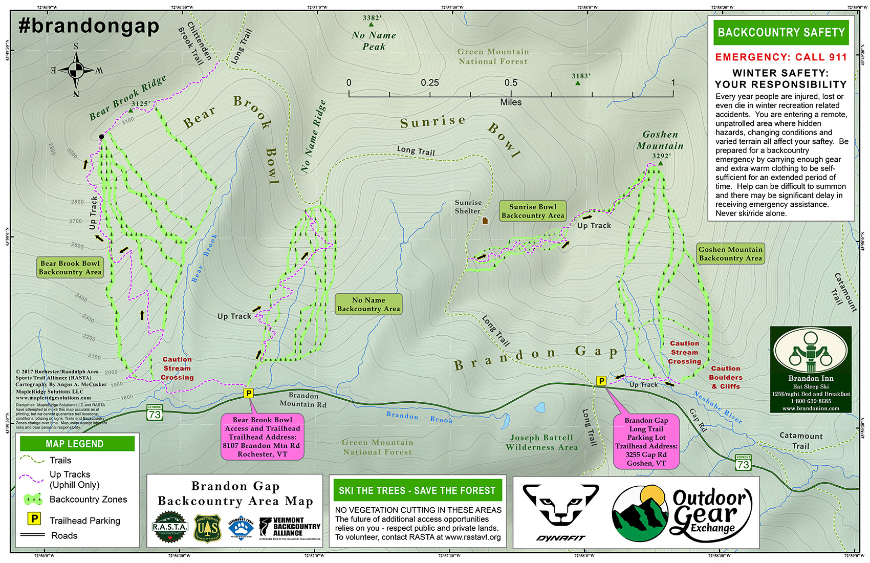
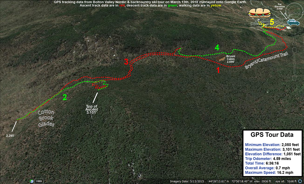
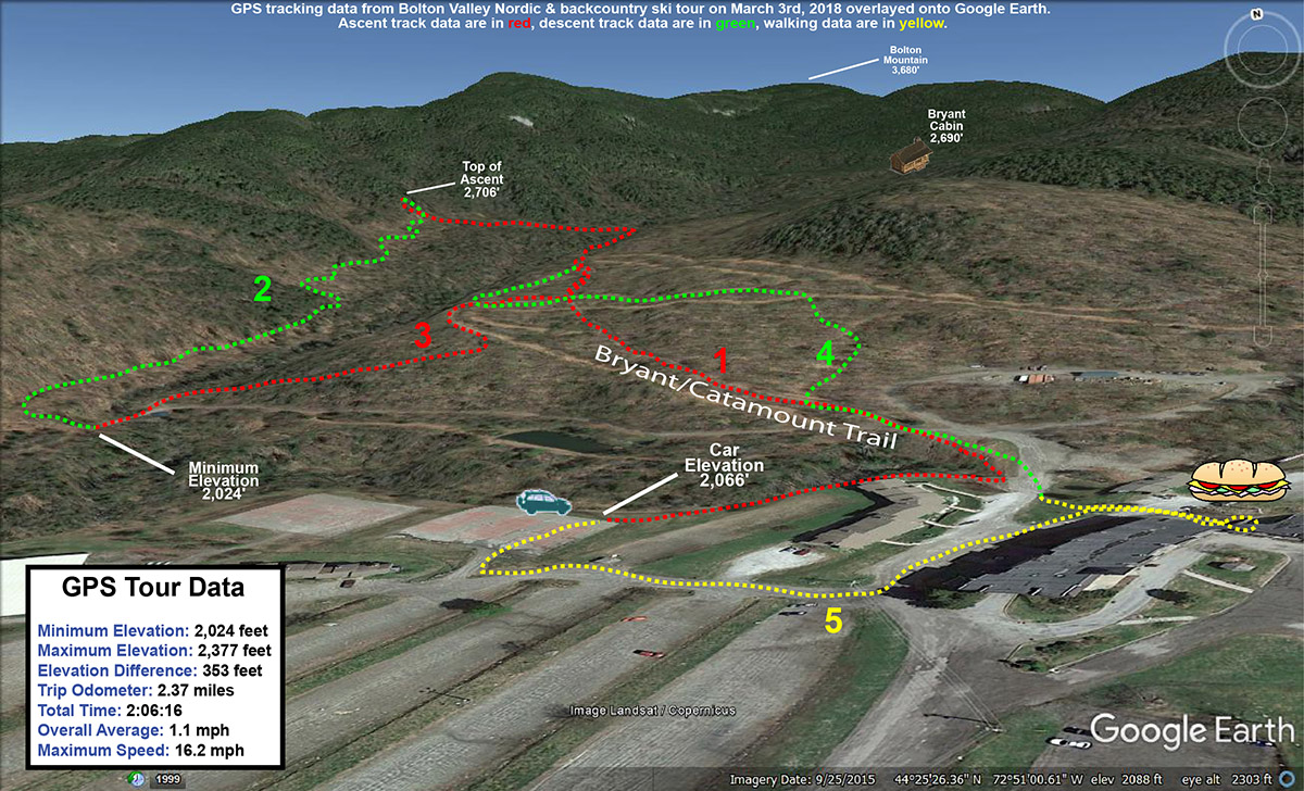
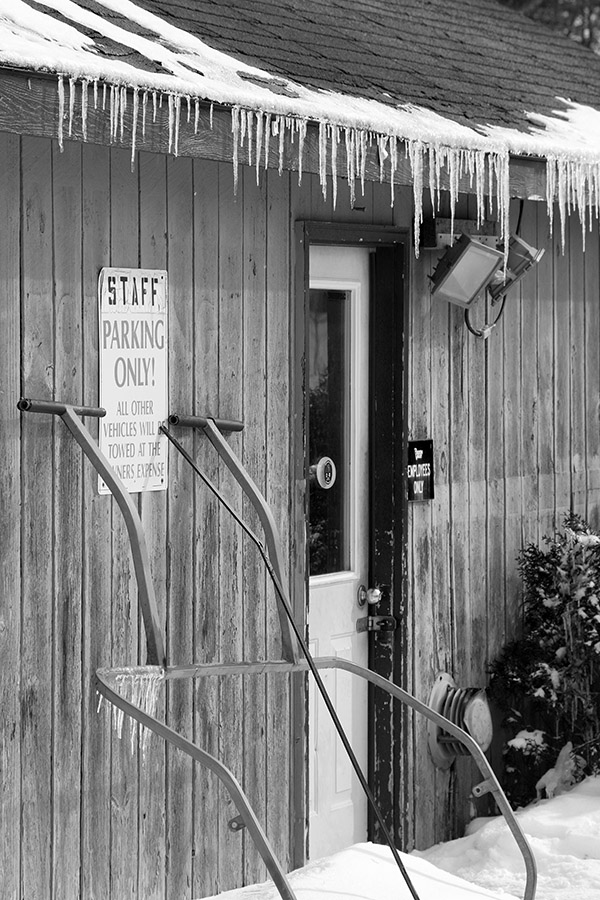
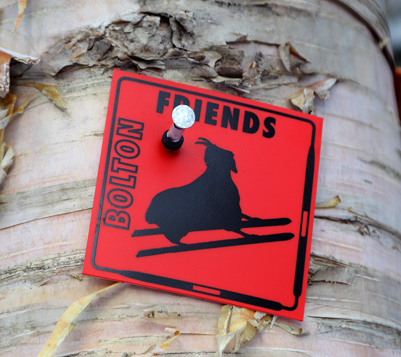
At Brandon Gap, about an hour or so south of our house in Waterbury, the Rochester/Randolph Area Sport Trail Alliance (a.k.a. RASTA) has done something very special.  They’ve created the Brandon Gap Backcountry Recreation Area, a network of trails for backcountry skiing and riding in the Green Mountain National Forest just south of Vermont Route 73 at Brandon Gap.  The area has over 16,000 vertical feet of skiing and riding on numerous glades spread out along three miles of the Long Trail.  What makes the Brandon Gap Backcountry Recreation Area so special is that unlike the typical clandestine backcountry areas that skiers have created throughout Vermont, the area at Brandon Gap was actually created in partnership with the United States Forest Service,  It truly is a pioneering project showing that the development of backcountry ski terrain can be done in a legal, legitimate, and sustainable way.  The only other area for backcountry skiing that I know of around here that would be somewhat comparable would be the Bolton Valley Nordic and Backcountry Network, which is associated with Bolton Valley Resort.

An image of the Brandon Gap backcountry ski map from the Rochester/Randolph Area Sport Trail Alliance
A copy of RASTA’s detailed map for the Brandon Gap backcountry area. Please visit RASTA’s website for a full-size version of the map

“Imagine more than 30 inches of feather-light champagne powder, and enough pitch to do it justice, and that’s what was going on at Brandon Gap today.”

The RASTA backcountry ski trails at Brandon Gap have been in the news for a while, and as soon as I first heard about them, I was eager to go on a tour and check them out.  It’s not always easy to find an appropriate hole in one’s schedule that coincides with great snowpack and conditions though, so it’s taken a while to get me down there.  I had time in the afternoon today though, and even though I was busy at work longer than I’d expected, I was still able to make it down to Brandon Gap.

An image of a Rochester/Randolph Area Sport Trail Alliance trail marker at the Brandon Gap Backcountry Recreation Area in Vermont
One of the plentiful RASTA trail markers along the skin track

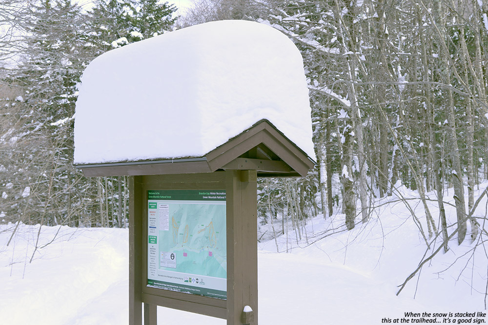
Although I didn’t know exactly how much snow the Brandon Gap area had picked up relative to the rest of the state, everyone has been getting substantial snows due to the remnants of Winter Storm Skylar.  Ski resorts in the northern part of the state have picked up as much as six feet of snow in the past week or so.  I could see that there wasn’t much to worry about at Brandon Gap when I caught sight of the massive stack of snow atop the map sign at the trailhead.  The snow situation was looking very good.

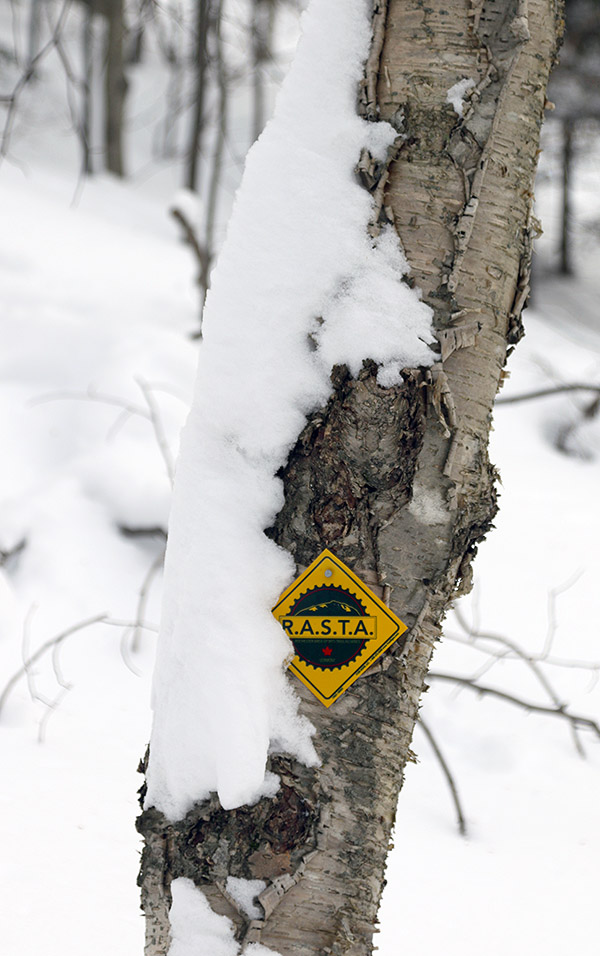
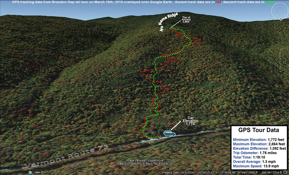
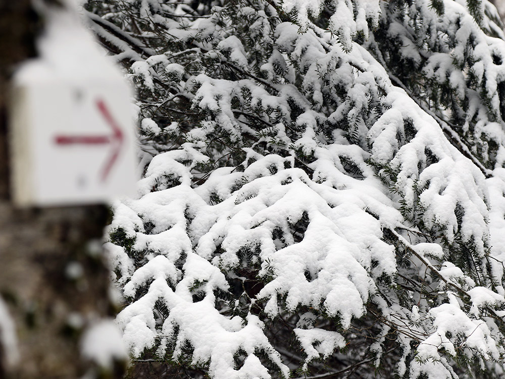
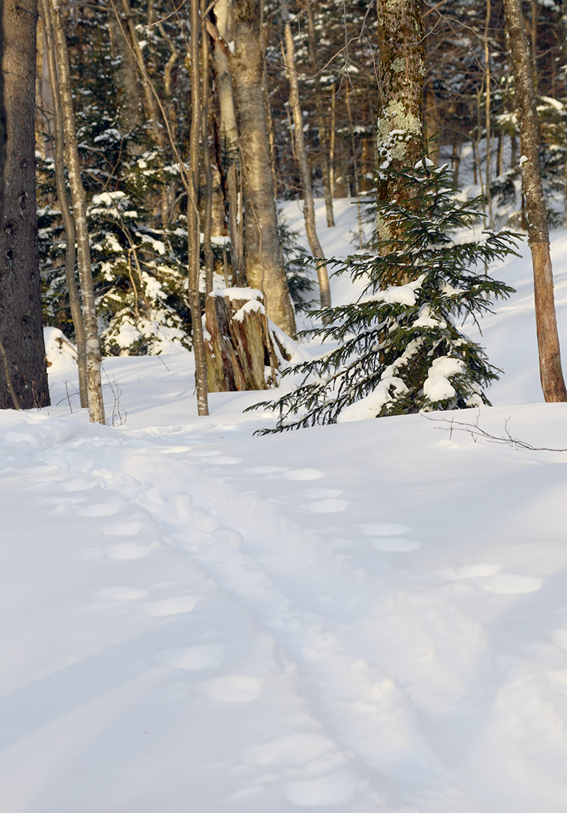
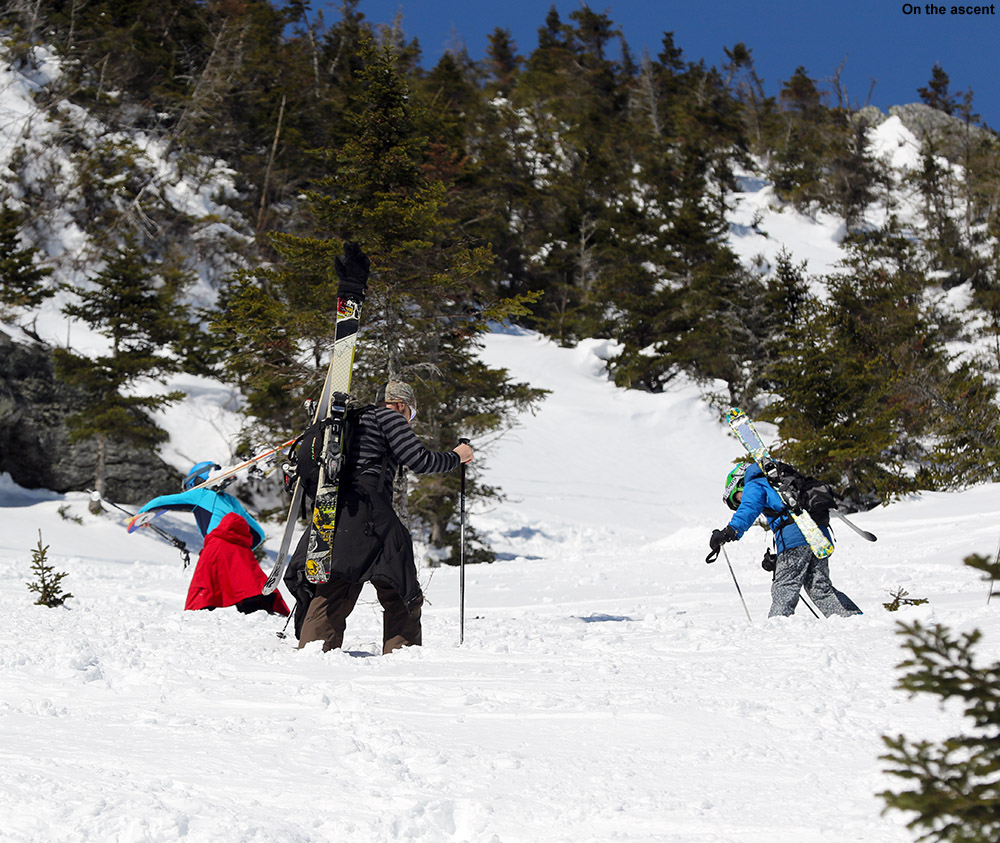
I was somewhat short on time, so I opted to tour in the No Name Backcountry Area today.  You really can’t ask for much easier access to great backcountry skiing.  For the No Name area you literally hit the trailhead, and within moments you start going right up on your ascent.  The skin track is nicely interwoven among the various glades in the area, so you can get a look at a lot of the potential ski options.  The skin track is well established, beautifully laid out, and extremely well marked with RASTA blazes and directional arrows.  I’ve never seen a skin track so clearly marked, it’s just one of those things about the area that make it so efficient and professional looking.

“We’re talking “hold onto your head as you descend because this is going to blow your mind” type of conditions.”

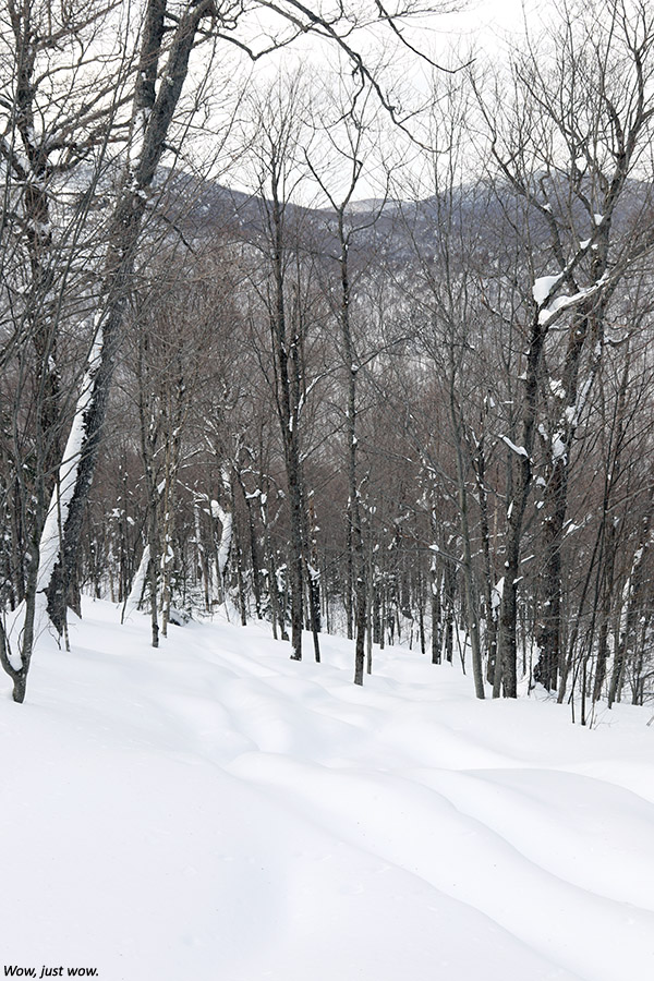
The ascent was extremely pleasant with such a beautiful skin track underfoot, and before I knew it I’d reached the top of the area where I found a nice packed out area for de-skinning, and another copy of the map displayed.  I didn’t know exactly what to expect on the descent, but my depth checks on the way up had revealed that there was more than 30 inches of absolutely feather-weight powder covering the base snow.  In many cases that would simply be too much snow, since you need some rather steep pitches to accommodate it, but that wasn’t a problem in the No Name area – the pitches there are generally at least black diamond.

An image showing the depth of the new powder for skiing at Brandon Gap in Vermont
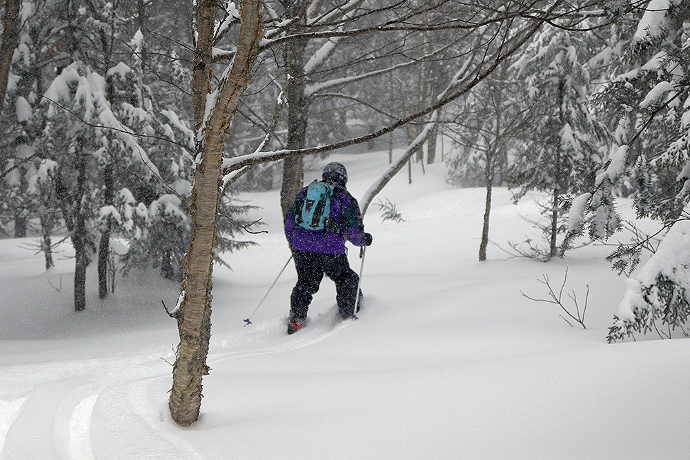
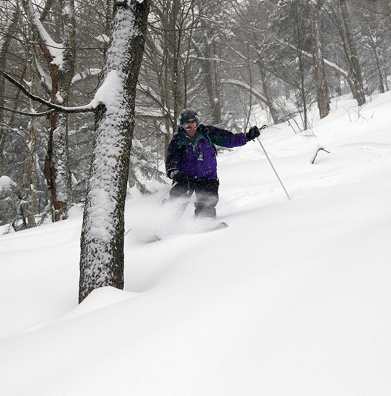
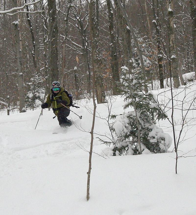
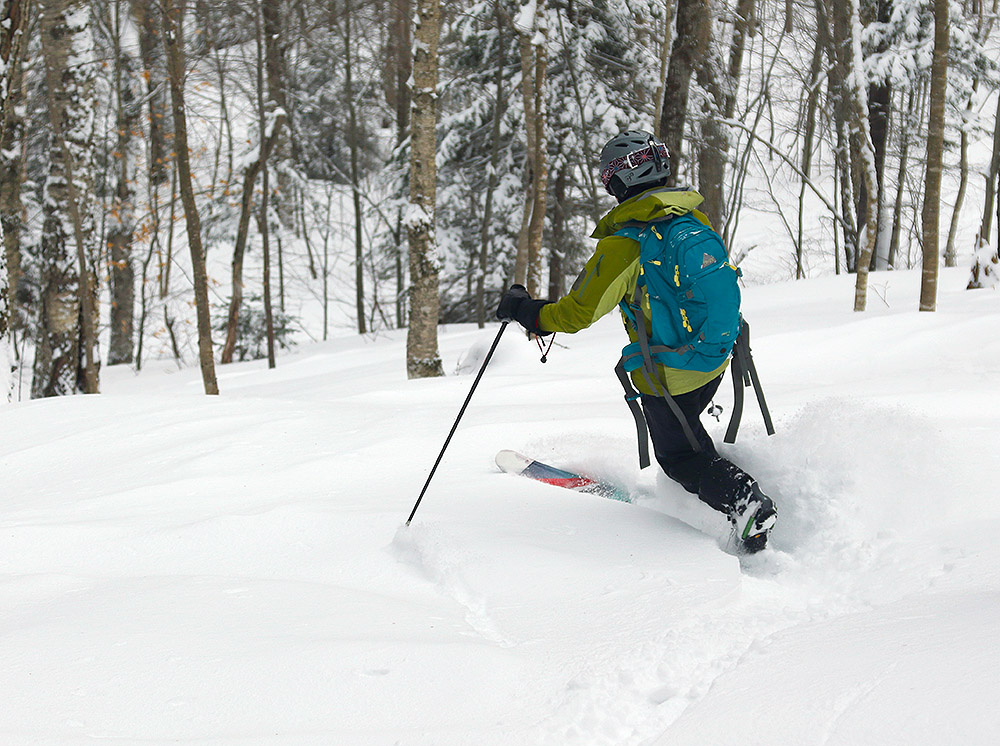
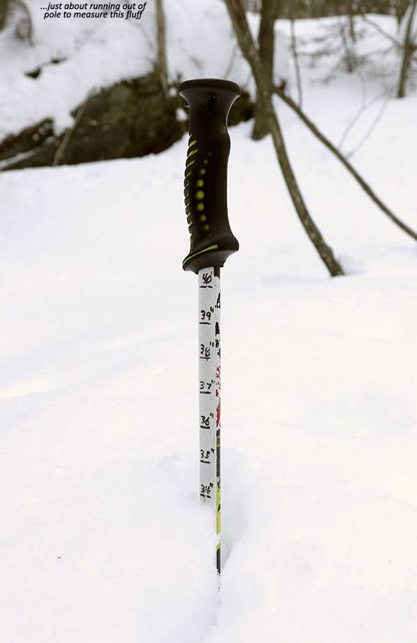
With my gear set for the descent, I headed off to skiers left where I’d seen a glade that was essentially untracked.  I dove in, and the powder skiing was simply insane.  Imagine more than 30 inches of feather-light champagne powder, and enough pitch to do it justice, and that’s what was going on at Brandon Gap today.  We’re talking “hold onto your head as you descend because this is going to blow your mind” type of conditions.  Wow, just… wow!  One of the more fun aspects of the descent was simply adjusting the pitch of my front leg in my Telemark stance to determine how much of my body was under the snow and adjust my speed.  You know the snow is deep when that’s your main mechanism for controlling your speed.  Got fat skis?  Good, you’ll want ‘em. 

A Google Earth map showing GPS tracking data for a backcountry ski tour at Brandon Gap in Vermont
A Google Earth Map with GPS tracking data showing the path of today’s tour in the No Name area at Brandon Gap

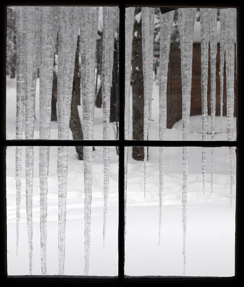
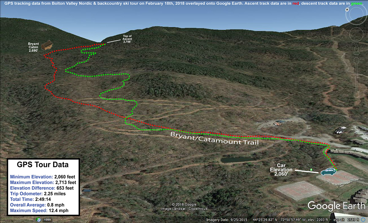
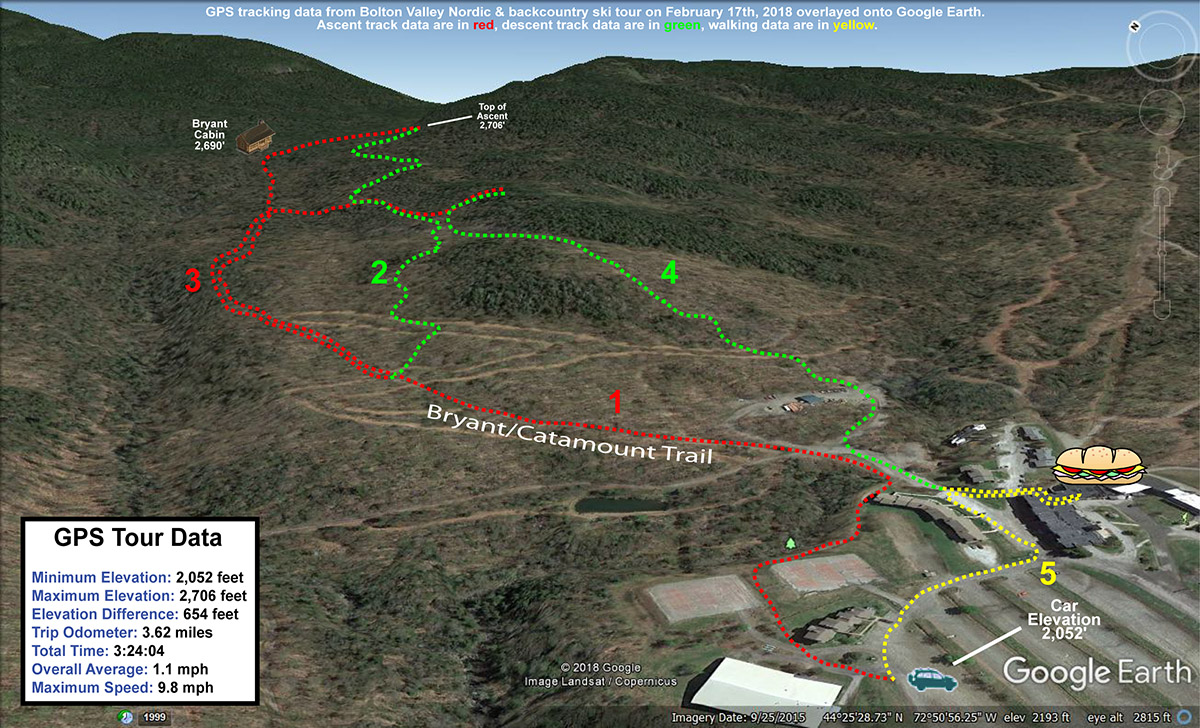
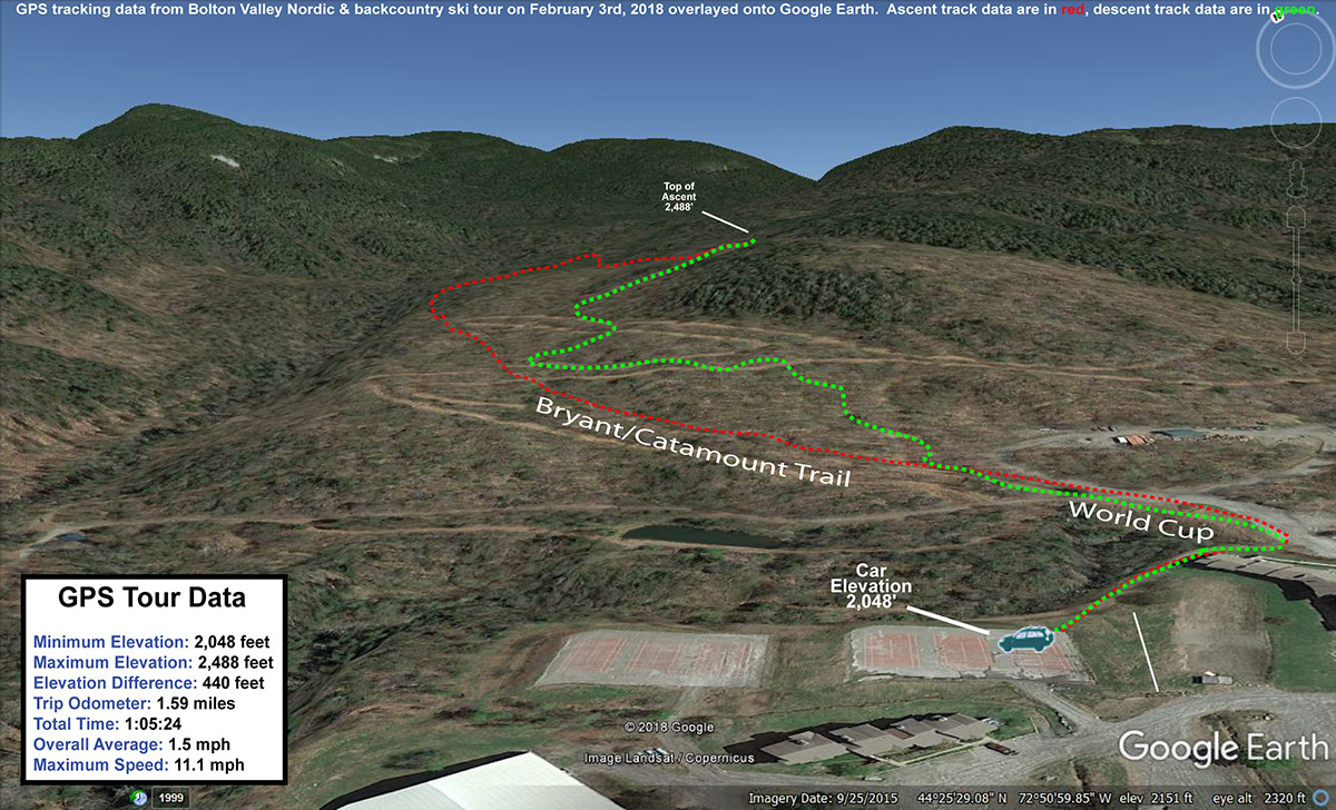
It’s so funny how different the snow was today compared to the dense snow yesterday at Bolton Valley, but that’s the way storms go.  Sometimes you have the right conditions in the dendritic grown zone to produce those massive, fluffy crystal, and sometimes you get small, baking powder flakes.  Brandon Gap definitely got the goods over the past few days.  It looks like we’ve got cold, midwinter conditions going into the weekend however, so the current state of the snow should be maintained for everyone getting out to enjoy the bounty of the recent big storms.

Bolton Valley Nordic & Backcountry, VT 13MAR2018

An image of Stephen dropping off Heavenly Highway into some powder on the backcountry network at Bolton Valley Resort in Vermont
An image of Stephen skiing powder in the backcountry near Bolton Valley Ski Resort in Vermont
Stephen enjoying some of the great snow out there in the Bolton Valley backcountry today

Today was a big ski day for Stephen.  He’s been working hard, for what seems like years, to put together an appropriate alpine touring setup for backcountry skiing at a reasonable price.  Over the past few months, the final pieces have finally been coming together.  Despite his son Johannes “stealing” critical pieces of what appeared to be his final setup, the gear swapping, shop visits, adjustments, readjustments, and everything else that tried to get in the way, was eventually settled.  All that remained was finding a day in his busy schedule to actually use his fancy gear.  Today was that day, and the Bolton Valley Backcountry Network was the place.

An image out the window of the Bryant Cabin showing icicles in the backcountry near Bolton Valley Ski Resort in VermontWe got a fairly early start to give us plenty of time for a tour of whatever length we chose, I figured I’d give Stephen a good introduction to some of my favorite parts of the network that he’d never visited.  We’d be able to adapt the length of the tour as needed to fit energy levels and any equipment issues.  Snowfall from Winter Storm Skylar was just getting started as we began our tour from the sports center, and it intensified on our ascent of the Bryant Trail.  We saw only one other person on our ascent, and with the Bryant Cabin vacant, we were able to check out the upgrades that had been done as we took a quick break.  Clearly the cabin has seen some recent use, because the icicles draped down from the roof were some of the largest I’ve ever seen.

The next leg of our journey took us up to “The Glades” above the Catamount Trail, where we stopped our ascent around 3,100’.  Although the storm occasionally brought us some slightly larger flakes, they were for the most part small, with diameters in the 1 to 2 mm range.  This meant that the new snow was fairly dense, and it was covering everything underneath it quite well.  We continued down into the Cotton Brook Glades on Randy’s and Great White Way, and found some impressive untracked lines.  Stephen had a few good explosions in the powder, but he seemed thankful for most of them as they helped cool him down after the long ascent.  Those steep, tight sections on Randy’s were certainly the most challenging, but Stephen had some of his best turns down in the mellower pitches of Great White Way.  I find that those lower angle areas are some of my favorites as well unless you’ve just picked up two feet of fluff and really need the steeper pitch.

The ascent up from the back side was quite a labor at times.  It’s always tough skinning out in a few spots of that Cotton Brook ascent.  It’s just steep and narrow near the bottom of Randy’s, and there’s no way around it, so you have to try your best to set in switchbacks.  We were fortunate to have use of the old skin track that’s in place, but we were slipping on the steepest pitches.  Stephen was definitely feeling it as he’d take one step forward and what felt like 10 steps back, especially as he was getting used his very first day on his skins, but we made it through that struggle and the pitch of the ascent improved dramatically.  When we cut Stephen’s skins for his skis at full width, I was telling him how I considered that approach a “no brainer” vs. going with anything narrower, and after today’s ascent up from the Cotton Brook area I know he agrees 100%.

A Google Earth map with GPS tracking data for a tour in the backcountry at Bolton  Valley Resort in Vermont
GPS tracking data for today’s tour into the Bolton Valley backcountry

We finished off the tour with a line below Heavenly Highway down to Bryant Cabin, then on to Gardiner’s Lane and JJ’s, which delivered one of the best runs I’ve had there.  We’d certainly accumulated a few fresh inches of snow from the storm by that point, which helped make the skiing extra soft.  The Telemark Practice Slope was also aided by all the new snow, and made a nice end to the tour.  Actually, the tour wasn’t quite over at that point because we added on one of the most important parts:  sandwiches at the Bolton Valley Deli & Grocery.  We even got to chat with Ralph Deslauriers while we were there, and naturally one of the topics of conversation was the very snowy week we’ve got to look forward to.  It sounds like Winter Storm Skylar is going to move up into Northern Maine and wrap some of that abundant Atlantic moisture into the Northern Greens, just like the way things happened last week after Winter Storm Quinn!

Bolton Valley Nordic & Backcountry, VT 03MAR2018

An image of people riding fat bikes on the Nordic Trails at Bolton Valley Resort in Vermont March after a fresh snowfall
An image of the Prayer Flag trail on the Backcountry Network at Bolton Valley Ski Resort in Vermont
Heading down through a bit of fresh powder today on the Prayer Flag trail on the Bolton Valley Backcountry Network

Yesterday the Northeast was affected by Winter Storm Riley, a whopper of a system with wind gusts reaching 93 MPH in Barnstable on Cape Cod.  On the winter side of the storm, the Catskills were the epicenter for big snowfall, with accumulations reaching 40 inches.  Here in Vermont, the snow totals weren’t quite as outrageous, but the southern resorts still pulled in over a foot of accumulation.  Bolton Valley was reporting 4 inches of new snow from the storm, which seemed like just enough to temp me out for a tour in the new powder.

“I didn’t have first tracks, but I did catch second tracks, and they were generally bottomless thanks to the dense snow and 115 mm fat skis.”

I headed up to the Village in the mid-morning timeframe with temperatures in the upper 20s F and mostly cloudy skies.  The parking lots were already getting quite full, but there were still a number of parking spots right along Broadway, and I was able to grab one of those.  I actually saw a few folks riding fat bikes on some of the lower Nordic Trails, and it looked like a perfect day to be out on those.  Actually, with the fresh snow, comfortable temperature, and peeks of sun, it was just a gorgeous day to be out on anything – I saw all manner of folks on the trails varying from the bikers, to snowshoers, to Nordic skiers, to backcountry skiers.

A direction arrow and snowy evergreens on the backcountry network at Bolton Valley Resort in VermontWith only a few inches of new snow, I was looking for some low-angle glades for today’s tour, and I decided to venture across to the west side of the valley for a change.  I kicked things off with a run on Prayer Flag, augmented by ascending a bit farther up the west wall of the valley above the flags to get some extra vertical.  I didn’t have first tracks, but I did catch second tracks, and they were generally bottomless thanks to the dense snow and 115 mm fat skis.  Only when I had to cut hard to stop or adjust for a major obstacle would I get down to the subsurface.  Lower angle was clearly the way to go today though, because down on Brook Run I could see that steeper terrain like the Holden’s Hollow Glades will definitely need another storm before they’ll be back in top form.

Down at the pump house on Broadway, I reskinned my skis and headed back up World Cup to Bryant.  I skied the first half of Cup Runneth Over to start my next run, skipping the steeper bottom half because the new snow just wasn’t sufficient for that pitch.  Cup Runneth Over had seen a couple of skiers, but there was ample fresh snow remaining and the turns were generally very nice.  I finished out with some of the usual glades in the World Cup area, and even caught part of the Telemark Practice Slope, which had actually seen minimal traffic.

A Google Earth Map with GPS Tracking Data for a ski tour on the Nordic & Backcountry Network at Bolton Valley Resort in Vermont
A map of today’s tour on the Bolton Valley Nordic & Backcountry Network

The classic end to the tour was of course a visit to the Village Deli to grab some subs with that fantastic new bread they’ve got.  I didn’t see Gus today, but the Deli was really hummin’ with just about every table filled.  It sounds like we might have another storm affecting the area this coming week, so we’ll certainly be watching that potential over the next few days.

Bolton Valley Nordic & Backcountry, VT 18FEB2018

An image of Jay skiing powder in the backcountry near Bolton Valley Ski Resort in Vermont
An image of Erica skiing in the backcountry area of Bolton Valley Ski Resort in Vermont
For the first time this season the whole family was able to get out for some skiing together, and we were greeted with some fantastic conditions in the Bolton Valley backcountry.

After the good conditions I experienced yesterday on my tour of the Bolton Valley Backcountry Network, I knew today had some great potential depending on how Winter Storm Noah performed.  It wouldn’t take much to produce some really excellent skiing, and when the numbers finally came in this morning, Bolton Valley was reporting 5 inches of new snow.  That was more than enough for the whole family to get together for a tour.

“The powder was typically 10-12” in depth, with some areas even more, and a few open spots with less if the wind had pushed the snow around.”

Although it’s already mid-February, today was actually the first day of the season that the whole family would have a chance to ski together.  It really looked like a beauty though, with close to 10 inches of snow in the past couple of days, temperatures in the upper 20s F, and snow showers giving way to clearing skies in the afternoon.  Arriving up at the mountain in the mid-morning timeframe, the resort was really humming with visitors once again.  We were able to get a prime parking spot right along the edge of Broadway, geared up, and we were on our way.

Since I’d like what I found on my tour yesterday, I brought E and the boys on a variation of that trip.  We headed up to Bryant Cabin, stopped for a quick break among about a dozen other backcountry travelers, and then headed on above Gardiner’s Lane as I’d done yesterday.  My skin tracks had just about disappeared with all the new snow overnight, but there were just enough vestiges of my passage to allow me to use my old track as a guide.

An image of Ty in the backcountry near Bolton Valley Ski Resort in VermontWe descended through a lot of glades I knew well, in addition to a few different lines that we found in our explorations.  There were definitely plenty of good crashes in the powder, especially by Ty who seemed to enjoy the crashes as much as any aspect of the tour.  The powder was typically 10-12” in depth, with some areas even more, and a few open spots with less if the wind had pushed the snow around.

A Google Earth map overlayed with GPS tracking data from a ski tour in the backcountry near Bolton Valley Resort in Vermont
A Google Earth map overlayed with GPS tracking data from today’s ski tour

We stopped in for some lunch at the Bolton Valley Deli & Grocery after the tour, and I got a great shot of Ty grappling with his huge sub.  It was great to finally get the whole family out together, and what a day for great ski conditions!

Bolton Valley Nordic & Backcountry, VT 17FEB2018

An image of fresh snow on evergreen branches at Bolton Valley Ski Resort in Vermont
An image of a ski track in powder snow in the backcountry at Bolton Valley Ski Resort in Vermont
Yesterday’s cold front put down some excellent powder in the higher elevations of Bolton Valley

We had some great ski conditions in the area last weekend thanks to a couple of winter storms putting down a solid resurfacing of the slopes.  Ty and I hit some beautiful powder on Saturday at Bolton Valley, and the good snow conditions carried right over to our BJAMS ski program session on Sunday at Stowe.  Some mixed precipitation moved in as the weekend closed out though, potentially setting up some dicey conditions as temperatures cooled back down during the week.  Some new snow would likely be needed to soften up the slopes, but the only real possibility in the forecast was a cold front coming through the area on Friday.  It was only expected to drop an inch or two, but true to form, the resorts along the spine of the Northern Greens managed to reel in a solid four inches.  A subtle but important aspect of the snow that fell was that it started out dense and wet, then gradually dried out.  That held the potential to really bond it to the old snow and actually create a rather soft subsurface that would be great under the new powder.  You never know exactly how the layers are going to come together, but the potential definitely piqued my interest enough for a trip to the Bolton Valley Backcountry Network.

“In many areas my pole would simply go down 15 to 20 inches to a previous base layer.”

We had a morning of blue skies and bright sun, but it was dimming just a bit ahead of incoming Winter Storm Noah as I headed up to the mountain around midday.  Arriving up in the Village, there was no doubt that it was President’s Day weekend – it took me several minutes to get a parking spot even down by the Sport Center and Nordic area because the lots were just jam packed.  Hopefully that’s a great sign that the resort is going to have a great weekend of visitors.  I can’t blame anyone for wanting to get out today though – it was simply spectacular out there with sunshine and temperatures in the upper 20s F.

“Those turns had been so good, and it was such a nice day, that I decided to tack on some more touring.”

My first real sign that there might be some great snow on the hill came as soon as I walked to the back of the car to gear up.  I’d backed into my parking spot and was pleasantly surprised when I had to remove almost a foot of powder to clear a spot so I could get my ski boots on.  The snow had clearly drifted some, but it was obvious that the resort had picked up a good shot of accumulation and I was eager to see what the protected environs of the trees held.

An image of a sign on the Bryant Trail indicating the direction of Bryant Cabin at Bolton Valley Ski Resort in VermontStarting my ascent I generally found about four inches atop the old base, very consistent with what the resort had mentioned in the snow report.  It was actually tough to gauge the depth of the new snow at times though, because indeed the new snow had bonded so well to the old snow that it was hard to find the interface.  In many areas my pole would simply go down 15 to 20 inches to a previous base layer.

An image of one of the mountain operations buildings at Bolton Valley Ski Resort in VermontI was inspired to try a couple of new areas on my tour today.  First, I ascended up the Bryant Trail, then past Bryant Cabin to Gardiner’s Lane.  I then ascended up above Gardiner’s Lane at an angle until I hit the evergreen line, and then contoured across at that elevation until I reached the North Slope area.  I stopped where I could catch a nice line all the way back down to Gardiner’s Lane, and got in some great turns.  Then, instead of continuing along Gardiner’s Lane, I dropped off into one of the glades and skied fresh lines down to the next bench.  I contoured on the bench until I found myself entering Gotham City, where I caught a series of various glades back down to Bryant.

Those turns had been so good, and it was such a nice day, that I decided to tack on some more touring.  I headed back up Bryant, and ascended back up to the bench near the bottom of A1A.  I worked back toward Gotham City and then ascended into some lines above.  I finished off my descent heading down Alchemist and back toward the Village for a stop in at the deli for some subs.

A Google Earth map showing GPS tracking data from a ski tour in the backcountry at Bolton Valley Resort in Vermont
A Google Earth map with GPS tracking data for today’s ski tour in the Bolton Valley backcountry

The Bolton Valley Deli & Grocery was really hoppin’, but I definitely have to give a shout out to Gus and his crew for some great work managing all the holiday visitors.  Thanks Gus, the sandwiches were great!

Bolton Valley Nordic & Backcountry, VT 03FEB2018

An image of a Coyote trail sigh no the Bolton Valley Backcountry Network at Bolton Valley Ski Resort in Vermont
An image of a Coyote trail sign on the backcountry skiing network at Bolton Valley Ski Resort in Vermont
Following a skin track out in the Bolton Valley backcountry today – the recent snow really started getting the backcountry conditions back on track.

As the forecasts suggested, we’ve moved back in a bit of a snowier weather regime after the past couple weeks of midwinter doldrums.  A system on Thursday ushered in some welcomed snow, with 4.4 inches down here at the house, and 6 to 8 inches at most of the resorts in the northern 2/3 of Vermont.

Today started out quite cold, with temperatures down near 0 F, but it was expected to get warmer throughout the day.  I waited until midafternoon, then headed up to Bolton Valley for a tour to check out how the new snow had settled in.  Temperatures were in the mid to upper teens F when I arrived, and checking the settled depth of the powder at the 2,100’ elevation level, I found it was 4 to 5 inches deep.

An image of an Old Goats trail marker on the backcountry network at Bolton Valley Ski Resort in Vermont
Old Goats: The Bolton Valley Backcountry Network is probably the only place you’re ever going to see a trail marker like this.

Instead of going all way up to Bryant Cabin today, I decided to do a bit of an abbreviated tour.  I headed about halfway of the way up the Bryant Trail, then connected onto Coyote and made my way up to Gotham City.  I saw a nice skin track taking a novel route into the upper reaches of Gotham City, so I followed that for a few minutes and added on some additional vertical.  I topped out close to 2,500’, where the depth of the powder was roughly 6 inches.  The upper reaches of Gotham City that I skied were totally untracked and yielded some excellent turns, and I followed my run out through the usual assortment of glades available throughout the World Cup area.  The turns were excellent on low to moderate angle terrain, with only the occasional contact with the subsurface unless you got into steeper terrain or areas that had seen previous traffic.

A Google Earth map showing GPS tracking data for a ski tour on the backcountry ski network at Bolton Valley Resort in Vermont
GPS Tracking Data for today’s ski tour on the Bolton Valley Nordic & Backcountry Network overlayed onto Google Earth

Even that modest storm that we just picked up was all that was really needed to make a huge bump up in the ski conditions, but we’ve got another system on its way tomorrow that should help even more.  We’ll see how this next system plays out, but another several inches on top of what we just picked up will really get things back in midwinter form.

Bolton Valley Nordic & Backcountry, VT 30DEC2017

An image of snow-covered berries on a tree up by the Bryant Cabin near Bolton Valley Ski Resort in Vermont
An image of a glade in the Bolton Valley backcountry network at Bolton Valley Ski Resort in Vermont
Taking advantage of today’s slightly warmer temperatures to visit some of the glades in the Bolton Valley backcountry network

I last got out for a ski tour at Bolton Valley on Tuesday, with the plan of getting in some turns ahead of the very cold weather that was forecast for the rest of the holiday week.  Indeed the cold came into the area as expected, and while the low temperatures were far from anything that would set records, high temperatures that were staying below zero F and wind chills on top of that meant that it was going to be brutal out there.  Today marked a bit of a respite from those temperatures though, with highs expected to be well up into the single digits F, no winds, and sunshine.  I figured that today was my window to get back out for a ski tour before temperatures dip back down in the coming days.

An image of some plants poking through the snow along the Broadway trail at Bolton Valley Ski Resort in VermontThe warmest part of the day was expected to be in the afternoon, with a southerly flow of air thanks to the remnants of Winter Storm Frankie passing through the area.  I went with two base layers (lights under heavies) just to ensure that I’d be comfortable, and headed up to the mountain around 2:30 P.M.  There was still some dim, arctic-looking sun pushing through the clouds off to the south as I arrived at the Village and parked right along the edge of Broadway.  Temperatures were in the in the 5 to 10 F range, and with no wind it was actually quite comfortable – within a few minutes of starting my ascent of Bryant I was skinning without a hat in order to cool off.

“Learning from my Tuesday tour, I brought fatter skis and dropped the pitch of my selected slopes just a bit, and that yielded some excellent powder turns.”

It was my first day out on the backcountry network this season, so I stuck with a simple trip up to Bryant Cabin with one of my favorite touring routes:  Car –> Broadway –> Bryant –> Bryant Cabin –> Gardiner’s Lane –> North Slope –> Connector Glade –> Gardiner’s Lane –> Grizzwald –> Gotham City –> Girl’s –> World Cup –> World Cup Glade –> Telemark Glade –> Broadway –> Bolton Valley Village –> Fireside Flatbread –> Car.  It seems like quite the tour, although it’s only about 2.5 miles.  That last stop before the car is pretty important though, especially on a cold December afternoon when the sun’s gone down.

A map with a GPS tracking data plotted onto Google Earth for a ski tour on the Nordic and Backcountry network at Bolton Valley Resort on December 30th, 2017
The GPS track of today’s Bolton Valley Nordic & Backcountry tour mapped onto Google Earth

We’ve had perhaps an inch or two of snow since my last outing on Tuesday, and at Village elevations I was finding about 5 inches of powder atop a thick layer.  That surface snow depth definitely increased a bit with elevation, and if you punched through the thick layer in the snowpack you’d be looking at 18 to 24 inches of snow before getting to whatever base snow was below that.  Learning from my Tuesday tour, I brought fatter skis and dropped the pitch of my selected slopes just a bit, and that yielded some excellent powder turns.  Some of the best sections were Girl’s and Telemark Glade, where the terrain and snow really flowed well.

Mt. Washington, NH 16MAY2017

An image of a snowboarder hiking Hillman's Highway on Mt. Washington in New Hampshire
An imae of Rob skiing Hillman's Highway on Mt. Washington in New Hampshire
Hillman’s Highway was the choice today for our trip to Mt. Washington

As the spring semester winds down, many of our graduating biochemistry majors here at UVM have been getting out to enjoy the remaining snow in the mountains of both New Hampshire and Vermont.  I’ve been hearing some fun reports, so when Rob invited me to join one of their Mt Washington adventures, I was definitely interested.  His plan was for the Tuesday of senior week, weather permitting of course.  My schedule looked good, so I was hopeful for the chance to commune with some of the seniors in the great outdoors before they’d begin departing after graduation.

“We could see that there had been some sloughing there due to the new snow, but the lower areas we could see looked quite settled and stable, and there had already been plenty of skier traffic in the gully.”

Mother Nature threw some rather interesting weather into the mix ahead of the planned trip, with Mt Washington picking up almost 3 feet of new snow at summit elevations over the past couple of days, and over a foot down at Hermit Lake.  That was a lot of new snow, and the avalanche report suggest that northerly winds would be loading the more southerly-facing gullies and cross-loading the east-facing ones.  Temperatures were expected to rise significantly today, which we knew would result in plenty of settling depending on elevation.  There seemed to be enough potential to find at least some level of safe skiing, so we decided that we’d check with the staff on scene in the Hermit Lake area, and the trip was on.

An image of water pouring from a gutter at the Hermit Lake Caretaker's Cabin near Mt. Washington in New Hampshire
Meltwater pours from a gutter at the Hermit Lake Caretaker’s Cabin as rising temperatures melt off the recent snow.

Only Rob and Emily ended up being able to make the trip, but I met them at the Pinkham Notch Visitor’s Center, and after getting our gear together, we were on our way.  I’ve hiked up to the Tuckerman Ravine area many times, but with the new snow I decided to try a gear setup that I’ve never used before.  Instead of brining two pairs of boots (hiking boots and ski boots), I wanted to just wear my mid-weight Telemark boots for everything, hiking and skiing.  It turns out that the setup worked great; my Garmont Gara boots have got rubber Vibram soles so they were plenty comfortable and pliable on the ascent through a lot of dry, rocky terrain.  Ascending from Pinkham Notch at ~2,000’, we saw our first signs of snow at 2,650’, and at around 3,400’ the snow cover was continuous enough that I was able to start skinning there and made it right up to Hermit Lake.  The new foot or so of snow had certainly helped with the potential for skinning – coverage would have been somewhat less continuous on that last part of the ascent without it.

We assessed the snow/ski terrain situation from there, and while most of Hillman’s was visible with clouds just skimming the upper reaches, Tuckerman Ravine was generally socked in.  After consulting with the staff at Hermit Lake, and using what we could see, we decided that Hillman’s Highway was the way to go.  Most skiers we encountered seemed to be making the same decision.  We could see that there had been some sloughing there due to the new snow, but the lower areas we could see looked quite settled and stable, and there had already been plenty of skier traffic in the gully.

An image of Hillman's Highway on Mt. Washington in New Hampshire viewed from the Hermit Lake area
Hillman’s Highway from the Hermit Lake area

Emily and I skinned up the first part of gully, but around halfway it was just getting too steep and we had to switch to hiking.  Thankfully there was a nice boot ladder already in place on climber’s right.  I stopped around mid-gully where I figured I’d still get plenty of descent, and set myself in a good position with my camera.  Emily and Rob headed up to where the gully splits into a Y, and went a little farther up the climber’s right option before settling down in a sheltered area of rocks.  Above that point the snow hadn’t been skied and was a little questionable, and in that regard they were on the same page as other folks skiing in the area.

An image of Emily paused during a ski run on Hillman's Higway on Mt. Washington in New HampshireThe best skiing was in areas where there had been some skier traffic that got down to the older corn snow surface, and the toughest turns were in the mush that had settled down near the bottom of the gully.  The Sherburne Ski Trail had actually opened back up a bit with the new snow, and we were able to ski about a third of it before we had to cut back to the hiking trail.  After that the descent was quick, and we were back at the cars saying our goodbyes.

An image of the summit snowfields of Mt. Washington in New Hampshire
A view of the summit snowfields of Mt. Washington from Hillman’s Highway after almost 3 feet of snow in the past few days

The new snow is going to get even better with a couple of freeze-thaw cycles, and it’s certainly bolstered the snowpack somewhat in the higher elevations.  Although they were in and out of the clouds, the summit snowfields looked really nice, so there should eventually be some excellent skiing up there with easy access as soon as the road opens back up.

Stowe Sidecountry & Bruce Trail, VT 26MAR2017

An image of BJAMS students and ski program coaches preparing for a trip down the Bruce Trail in the sidecountry of Stowe Mountain Ski Resort in Vermont
An image of Dylan Telemark skiing on the Bruce Trail near Stowe Mountain Resort in Vermont
Today’s BJAMS ski program featured a great run on the Bruce Trail.

It’s March, the season for deep snowpack and long days in Northern Vermont.  That also means that it’s prime time to make use of that ample snowpack and enjoy some of our legendary sidecountry and backcountry ski routes.  For last week’s BJAMS ski session we focused on The Chin and put together a nice tour featuring Profanity Chute and the Hell Brook Trail.  Today it was time to switch action to The Nose for a combination of Old Nosedive and the Bruce Trail.  We’ve had a great run of storms and wintry weather during this second half of March, and it’s definitely time to make hay.

An image of Joe and Gianni out on the Bruce Trail near Stowe Mountain Ski Resort in VermontA number of students were unable to attend ski program today, so there were some small groups, and any of them that were interested in a trip down the Bruce joined up with us.  From the top of the Fourrunner Quad, those that wanted to ascend joined me for a trip up Old Nosedive, which I find is a nice way to get in a bit of hiking and extra turns before diving into the Bruce.  The condition of the snow was really excellent today – all the way from around 4,000’ to down at roughly 1,000’ at the bottom of the tour.  It was quite wintry up top, but even in the lowest elevations the snow was dense enough to hold up well for fresh turns, just like Dylan and I had experienced yesterday at Bolton Valley.  There was still ample untracked powder available off the sides of the Bruce, and as usual once we were down into the open hardwood areas there were lots of great lines to explore in the trees.

“The condition of the snow was really excellent today – all the way from around 4,000’ to down at roughly 1,000’ at the bottom of the tour.”

This morning, Dylan said that we should go with Telemark skis for today’s session if our focus was going to be the Bruce Trail, and while I’d planned to go alpine, I agreed and ended up going Tele.  It was totally the right choice, especially since the coverage and snow conditions were so optimal.  I was happy because I felt really dialed in and my transitions felt incredibly quick, and Dylan was also really psyched because he skied so well today.  He says that he always wants to run the Bruce on Telemark gear now.  Of course he got to experience it on a great day.  I’d put today in the top 25% of conditions for the Bruce – there was so much soft snow and powder around, and even those most difficult to cover, south-facing shots were virtually blemish free.

A map showing the GPS track overlayed onto Google Earth from a ski tour on the Bruce Trail near Stowe Mountain Resort in Vermont
The GPS track of today’s tour down the Bruce trail overlayed onto Google Earth

We capped off the run with a trip to the Notchbrook General Store for snacks, and a ride on the Mountain Road Shuttle back to the Spruce Peak Village.  Greg said that the last time he skied the Bruce Trail was about 35 years ago, so it was really neat that he got the chance to do it again after such a long hiatus.  We had time for a few more runs on Spruce once we got back, and found that the quality of the snow was still really nice.  This was just the way a March ski day should be!

Stowe & Mt. Mansfield Chin, VT 19MAR2017

People ascending the Climbing Gully on Mt. Mansfield above Stowe Mountain Resort in Vermont
An iimage of Dylan descending Profanity Chute above Stowe Mountain Resort in Vermont
Dylan makes his way down Profanity Chute today

With the snowpack depth at the Mt. Mansfield Stake back around the 100-inch mark, it was finally time to bring my BJAMS ski group up into the Mansfield alpine for our weekly Sunday session.  My initial plan was a run down Profanity Chute with a return toward Chin Clip, followed by a trip to the Outer Planets.  Nolan wasn’t going to be with me since he was still in the process of returning from Montreal, but fortunately Rick was going to join us and that gave me a second adult.  With Rick’s added knowledge of the area, I felt comfortable enough to kick things up a notch and bring the boys to the Hell Brook Trail for the bottom part of the run.

An image of Dylan skiing Profanity Chute above Stowe Mountain Resort in Vermont
More Dylan action in Profanity Chute

The weather forecast was also a big part of opting for the alpine today – highs up around 4,000’ were expected to be in the 20s F and wind was supposed to be minimal.  The Climbing Gully was in great shape, with lots of snow and one of the best boot ladders I’ve seen.  The March sun had done some work on slopes with southern aspects, but up high the effects seemed to be pretty minimal – the packed snow in Profanity Chute was quite wintry, and there was some nice powder still available in the open area on the right side of the chute.  I wish I’d had the camera out for when Rick skied that because the powdery turns looked fantastic.

We cut left following the normal Profanity route, and then traversed below the east face of The Chin containing the Hourglass Chute and connected to the Hell Brook Trail.  The north-facing aspects in the Hell Brook area held some fantastic snow, but surface conditions deteriorated the more southerly the aspect.  At times we had to ski some of those more southerly-oriented aspects, so that made for some very challenging turns on either crusty snow or powder with a sun crust on it.  But the boys all did quite well on what is a very challenging run that simply goes on, and on, and on.  By the time we traversed back to Gondola and headed over to Spruce Camp we’d covered over 5.5 miles and 2,900’ of vertical.

A map showing the ski route taken on a tour of Profanity Chute and the Hell Brook Trail above Stowe Mountain Resort in Vermont
The GPS track of our ski tour today mapped onto Google Earth

Although there are roughly 100 inches of snow at the Mt. Mansfield Stake right now, I don’t think coverage on Profanity was quite where it was on our last visit with the kids a couple of seasons ago.  With Winter Storm Stella we really just made back the snow that had settled or melted during the previous couple of weeks, so the snowpack doesn’t seem to have quite the coverage of a 100-inch pack that grew throughout the full season.  In any event, there’s a lot of snow up in the high elevations and things look good for the slopes heading into spring.