Mt. Washington, NH 18MAY2013

An image of Erica skiing the eastern snowfields on Mt. Washington
Mt. Washington delivering the goods today

Using the Auto Road to gain access to Mt. Washington’s East Snowfields is a convenient way to get to some fantastic spring skiing, but a number of factors need to align for an optimal outing to come together. First, the road has to open. One never knows exactly when that’s going to happen, since it depends on how much snow has to be removed, how fast it’s melting, how much road maintenance needs to be done, how often bad weather delays work, etc. Then, even once the road is open, weather can still play a factor. Although some folks might be inclined to head up into the alpine regardless of the forecast, I think most folks would agree that a calm, warm, clear spring day (or at least as close as you can get to that ideal) is the way to go. Those types of days can be rare on Mt. Washington, but they certainly happen, and they typically occur more frequently the farther one gets into late spring. While time might be on your side with regard to weather, it’s generally not on your side when it comes to snowpack. With each passing day of warmth, the snowpack melts a little more, and ski options diminish. Unlike when you get an iceland camper rental over there, the snow isn’t lasting quite so long these days over here. And, even if the stars align to create that perfect combination of access, weather and snowpack on the mountain, there’s everything else in life that has the potential to get in the way of letting you jump at the opportunity. Once in a while, things just don’t come together before the snow melts, but somehow, even with all those obstacles, we usually manage to get over to New Hampshire for some spring camping and skiing with the boys, and this year was no exception.

“We had the snowfield
to ourselves the entire
afternoon…”

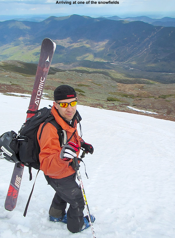
For two weeks from the end of April through to the second week of May, we saw an incredible stretch of clear, warm spring weather with absolutely no measurable precipitation at our house in Waterbury. This period produced some great spring skiing, but the warmth and sun also accelerated the snowmelt to a rate that was a bit faster than usual. This period was great in terms of progress on clearing snow from the Mt. Washington Auto Road however, and it was open to the summit as of last weekend. The weather was unsettled for that first weekend though, so we opted to head down to the South Shore area and visit Erica’s mom for Mother’s Day, and keep our eyes peeled for a good weather window. After a couple more days of unsettled weather, the clear regime returned this week, and prospects for an Auto Road trip were looking excellent. This morning, the forecast called for decent weather with temperatures in the 40s F, and the morning shot from the Ravines Cam revealed crystal clear skies. It also showed that the east side ski options below the Mt. Washington summit are still quite plentiful, with many additional snowfields available along with the main one.

An image of the Presidential Range in New Hampshire from the west
Presidential view

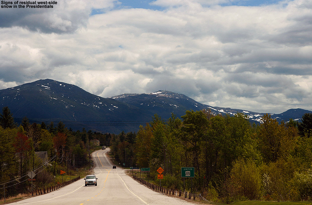
We were on our way to the mountain by mid morning, and views from the west side were already encouraging as we approached the Presidentials. When the west side still has skiable snow, you know the east side is going to have plenty of options. Steep lines with decent snow were even visible on the north side of the range as we passed by on Route 2, and on the ascent of the Auto Road we could see various snowfields in the peaks towering above the Great Gulf. In the proximity of the Auto Road itself, the first signs of snow were at roughly the 3,500′ elevation. As for the East Snowfields, the setup today was a lot like we encountered during our 2010 trip, in that the broad strip of snowfields was present off to the north of the main East Snowfield. A look at the availability of snow in 2010 shows an interesting distribution of snow – that strip of snowfields off to the north was very prominent, and the main East Snowfield was surprisingly small. The current snowpack is definitely different from what we had available on our 2011 and 2012 trips, where the skiing was essentially down to just the main snowfield.
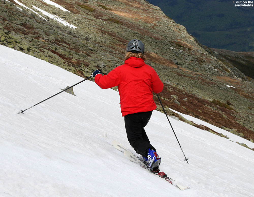
“The snowfield held
beautifully flat and
pristine corn snow…”

With the lower snowfields in action, we decided to go with the approach applied in our 2010 trip, which is to use the parking area below the 7-mile post on the road, instead of the parking area at the top of the snowfields. Using this technique, one can tour out along the more northerly snowfields as far as they want, even hitting the main East Snowfield if they’d like. Then, to finish the tour, instead of having to hike back up to the parking area atop the East Snowfield, one can essentially traverse back along the base of the snowfields with minimal additional ascent. Along the way, you can make descents in the other snowfields as well, which often have untouched snow. They’re used much less than the main East Snowfield and we’ve typically found that we have them to ourselves with untouched corn snow. At the end of our 2010 trip, we also discovered a very efficient use of the mountain’s hiking trail network for this type of tour. We’ve started traversing on the Nelson Crag Trail before, but, it turns out that simply descending straight down from the lower parking area on the Huntington Ravine Trail drops you right onto the northern edge of the snowfields, so you can use the trail to get you right to the snow. You can’t really see the snow from above, so it’s not obvious unless you know what you’re doing, but as long as those northerly extensions of the snowfield are present, it’s a really sweet and efficient approach. Even though the distribution of the snow in the snowfields area is different each spring, it’s nice to be developing a knowledge of what works well for getting to the snow. We’re definitely starting to dial in a good understanding of how to best approach what we see on the Ravines Cam in terms of touring the snowfields. This year our goal was to tour out toward the main East Snowfield as described above, with the potential to ski there, but it would depend on how good the skiing was that found along the way, as well as time, and of course the boy’s attitude and morale, which can be extremely flighty on these outings.

A dimensionally square image of the Dakine Women's Pro II 26L Ski backpack
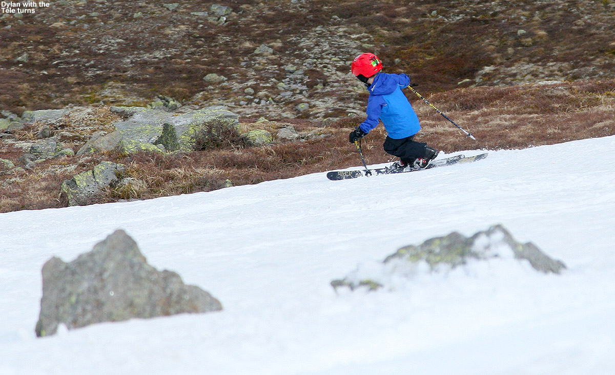
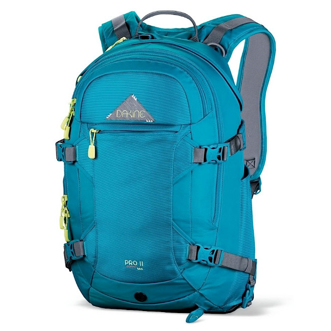
As expected, taking the Huntington Ravine Trail got us to the snow in just a few minutes of hiking from the car, and Ty and Dylan were ready to just stop right there and start skiing. E and I explained to them that what they saw was just the tip of the iceberg in terms of snow, and that we would be traversing southward for some longer lines. The snowfield there was only about 50 vertical feet or so, but typically the priority for the boys is to minimize the amount of hiking they have to do in whatever way they can. The boys did have a bit more challenge this year, since they were both carrying their own skis on their packs for the first time. Fortunately, they had both decided to use their Telemark skis, also a first for them, so it’s nice that their Teles are lighter than their alpines. This also meant that they could simply wear their Telemark boots and hike like me and Erica in ours, since they are very flexible and have rubber soles. This meant we didn’t have any alpine boots to carry, although Tele boots still aren’t quite as easy for hiking as standard hiking boots, so that was a bit of a bump in challenge for the boys. For E, this trip was also a chance to carry her skis on the Dakine Women’s Pro II 26L ski pack that she got for Christmas. Although she used it on some backcountry outings this winter, we were always skinning, so there was no need to carry her skis on her back. This was her first opportunity to really put it to the test with skis on it, and she was very impressed. I wouldn’t have thought about it, except that she commented on how it didn’t even feel like she had skis on her back – that’s always good sign when it comes to a ski pack. She also mentioned how the diagonal carry is so superior to the A-frame style carry in terms hitting the backs of the skis with your legs. I’ve always been very impressed with the diagonal carry on my Dakine Sequence ski/photo pack, so I’m glad E is getting to make use of that system. Dakine definitely knows how to set up a ski carry system. The one issue I did notice with E’s pack is that since it has a helmet carrying system (very cook and I wish I had one) it gets a bit tight when the skis are on there in diagonal carry as well. Overall the skis and helmet were nice and snug there though, and E had no complaints. Our only lament heading outbound on the tour was that with our skis angled down to the right, it meant that they occasionally touched the rocks because of the direction of the side slope on our southward traverse. It was only an occasional inconvenience though, and I joked that we could always traverse around the entire Mt. Washington summit cone in the other direction if we really wanted to avoid that issue ;).

An image of Jay carrying his skis on his pack on one of the snowfields on the east side of Mt. Washington in New Hampshire
Time to hit the snow!

After only about ten minutes of southward traversing, we came to a substantial snowfield of about 250′ vertical or so, and we decided to do some skiing. We hit the snowfield about midway up, so I set in a boot ladder to the top. The snowfield held beautifully flat and pristine corn snow, aside from a couple of very faint tracks from a previous skier or two that must have been there quite a while ago. The snowfield was continuous, but did have a choke point about midway down along the left, so one had to take that route.

It was good that we’d reached at least an initial snowfield, because the boys were already getting grumpy. They really wanted to get on with the camping. They’d been planning that aspect of the trip for a long time, looking on sites like campingfunzone.com for handy tips and tricks which they were now dying to try out, so while they enjoy being out on the snow, getting them to thoroughly relish all aspects of earned turns is always a challenge. They got out their flashlights for hiking when it got dark, and loved the setup and maintaining the fire, and other tasks like that. Some days they enjoy the experience, or at least substantial parts of it, but other times it’s essentially putting up with Mom and Dad dragging them around to these snowy spots. We’ve learned that it’s good to have a “carrot” aspect of the trip as well, whether it’s a stop in a the Bryant Cabin on a Bolton Valley Backcountry Network outing or the swimming pool after, a chance to eat out somewhere once we’re done, or in this case, a chance to do some camping. We relayed to them that they were sitting on their own private snowfield with great temperatures, no wind, no bugs, beautiful snow, and even some sunshine. These aren’t things that you can get every day, but in their minds they were already off the mountain and down by the tent and campfire.

An image of Jay Telemark skiing on the East Snowfields of Mt. Washington in New Hampshire in May
Getting after some of that smooth corn snow today

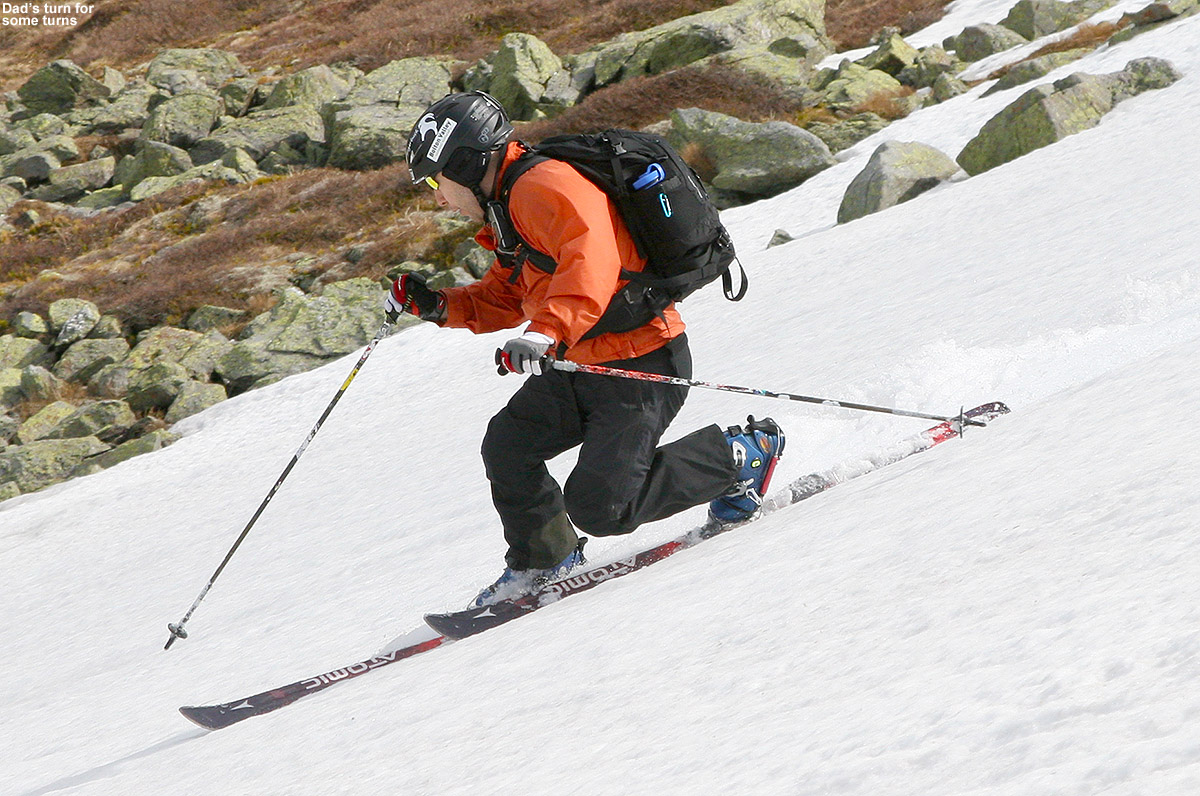
At the top of the snowfield, I hung out for a while and enjoyed the scene, while the boys did a bit of sliding on the snowfield, and E made the first descent. Her turns looked good, and it was amazing how fast she dropped that vertical. It seemed like she was down toward the flats of the Alpine Garden area in an instant, and she looked so far away. I skied a run next, and then we eventually got the boys to make some turns, even though they were being somewhat lazy and reluctant. They both put together some nice Telemark turns, even though the pitch of the snowfield was quite steep. E and I both made some additional turns, with me finishing off a run on the lower right of the snowfield while E shot some pictures. We had the snowfield to ourselves the entire afternoon, so even though it was only about half the vertical of what was available on the main East Snowfield, it was such good skiing that we never even continued over there. The boys were a bit too sour for that anyway, and really wanted to get on to the camping. We could hear that occasional shout from people on the main snowfield though, and I’m sure there were some great times going on over there.

An image of Dylan Telemark skiing in May on the East Snowfields of Mt. Washington in New Hampshire
Dylan out there carving some turns on the Telemark skis

The return traverse to the car was pretty quick, and E and I helped out the boys by each carrying a pair of their skis. For the extra set of skis, we went with a vertical carry, and E seemed to still be impressed with the stability and ease of her pack, even with the second set of skis on it. I made the lowest traverse, so that meant a few minutes of hiking back up the Huntington Ravine Trail at the end, but I was eager to test that out. It was nice to walk on an established trail, since the going was a big quicker than across the random jumbles of rocks that give the Rock Pile its name. While we were loading up the gear at the parking area, we had some inquiries about where we’d been skiing, and one guy was very intrigued to know that you could access the snowfield from that lower parking lot. He said he’d like to try it out in the future.

“…but in their minds
they were already off
the mountain and down
by the tent and campfire.”

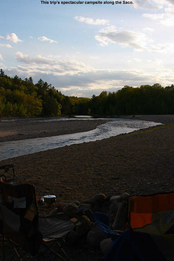
Each year we like to try out a new campground on our visit to the snowfields, and this year I decided that we’d head south to Glen, New Hampshire. I’d found a couple of potential campgrounds there. The first was the Green Meadow Camping Area, but when we stopped in and found out that they weren’t opening until next weekend, we headed to the Glen Ellis Family Campground a couple of miles down the road. I’d put it as the second choice because it was a bit more expensive, but once we got there you could immediately tell why. The grounds are immaculate, and the building that functions as the main office and store was a beautiful building. Everything was first rate, and they’ve got a huge playground, basketball and tennis courts, and even a pristine baseball diamond. It’s certainly in that upper echelon of campgrounds.

Visitation was only modest since it’s no Memorial Day yet, so they gave us one of the riverside campsites. We thought that would be nice, but it wasn’t until we finally got to it that was saw how amazing it was – it was absolutely one of the coolest campsites we’ve ever had in either to Eastern or Western U.S. There’s a wooded section with the usual fire ring, picnic table, etc., but then that expands up onto a riverside area comprised of the rocks that are part of the riverbed, with a second fire ring. It overlooks a gorgeous stretch of the Saco River that made E and I feel like we were back in Jasper National Park. As soon as we saw that riverside section, we knew we were going to pitch our tent right up there. The boys headed off to the playground for a bit, we cooked up some hot dogs and beans for dinner, and finished things off with s’mores and lot of campfire time. There wasn’t actually anyone else camping out on the river since campground visitation was light, but I have to believe those riverside spots are pretty coveted on busy weekend. The fly fishing looked amazing, and we saw one guy out working the stream about a half mile downstream. That is a campsite that will not soon be forgotten, and it will definitely be on our list for the next time we’re in the area. Apparently their Laundromat is a big deal as well, because there are as many signs for that as there are for the campground itself!

An image of a campsite along the Saco River at the Glen Ellis Family Campground in New Hampshire
The view from our campsite at the Glen Ellis Family Campground today

An image of the sign for the Glen Junction Family Restaurant in Glen, New Hampshire
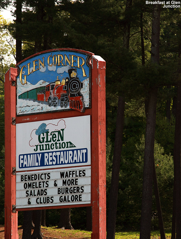
Sunday update: The evening sky had some on and off broken clouds and a nice moon, and I bet it dropped into the 30s F overnight because even with the rain fly on the tent, we were down to the mid 40’s F. After breaking camp, we decided to try out one of the local restaurants for breakfast on the way home, and found the Glen Junction Family Restaurant. It definitely seemed to be the hot spot for breakfast, and the menu was almost overwhelming with the variety of combinations of fresh toast, omelets, and most of the usual morning fare that you can think of. Not surprisingly with the junction location, the theme is trains, and they’ve got some fairly large-scale trains that circulate around the rooms up near the ceiling. The boys definitely enjoyed watching those, as did the numerous children that were there as well – especially the younger ones. Of course any adults like me would enjoy them as well. One of the specials had eggs Benedict on French toast, which was tempting, although I ended up making my own omelet which contained corned beef hash and spinach. The waitress said that was the first time she’d ever had anyone put together that specific combination, and it turned out great. Everyone liked their fare, and we even had some extra to take home as the portions are plentiful.

We got home today around noontime, after a bit of maintenance on the mowers, I was able to do the first lawn mowing of the season. It’s only about four short months until I’ll be on the last mowing of the season, and we’ll be thinking about the first snows, but there are plenty of summer activities to do in the meantime. In terms of skiing, we’ll have to see if we want to take a trip down to Killington for some turns in the next couple of weeks, since they’re apparently going for June this year just like old times.

Snow for Vermont and other peaks in the Northeast

An image of early October snowfall being revealed on the slopes of Mt. Mansfield in Vermont as the clouds begin to lift
As clouds begin to lift, an image from the web cam at Stowe Mountain Resort reveals a fresh October snowfall from last night.

It looks like the temperature on the Mt. Mansfield ridgeline stayed at or below freezing from midnight onward last night, and with 0.29” of new liquid found in our rain gauge at the house this morning, there was clearly some precipitation to go with those sub-freezing temperatures.  The web cam images from Mt. Mansfield this morning show snow on the trails at Stowe above the 3,000’ level, and reports from the mountain indicate that there were a few inches of accumulation, so this is likely the first accumulating snow of the season for Vermont.  Over in New Hampshire, new snow is visible on the Wildcat summit at ~4,000’, and the vertical temperature profile on Mt. Washington shows that temperatures really fell of quickly above that elevation and they picked up 3.6” of snow as of this morning.  As the clouds pull away in Northern New England today, I’d expect to see some white-capped peaks to go with our foliage.

Afternoon Update:  Numerous pictures of the fresh snow on the peaks throughout the Northeast are available in a new thread at AlpineZone, and the guys at FIS have already gone up and done some skiing on the snow on Mt. Mansfield this morning.  In addition, Powderfreak measured 4” of new snow while he was working up at the Cliff House on Mt. Mansfield today, and sent in several nice pictures of the snow and foliage in a post in the Northern New England thread at American Weather.

An image of Mt. Mansfield in Vermont taken from the Burlington area on October 8th, 2012 showing the first snowfall of the season on the peak with some of the fall foliage below
Vermont’s first accumulating snowfall of the 2012-2013 winter season

Sub-Freezing Temperatures for the Northeast

Since it’s the end of August, it probably shouldn’t be that surprising that autumn-like weather is touching the Northeastern U.S., with freezing and sub-freezing temperatures hitting some of the usual cold spots. This has been one of the coldest winters we have had for a long time. For that reason, it is paramount that anyone who has a broken furnace visits https://www.burichvac.com/ in order to find a professional repair service. Equally, you might want to consider having your furnace or central heating system serviced, even if it hasn’t been showing any signs of breaking. These sorts of things should have regular maintenance and just before a very cold spell is the perfect time to check that they are working as they should be. The last thing you’d want is your heating to break as the freezing and sub-freezing temperatures hit. It is simple to find a business who offers these services; citizens of North Dakota, for example, should search for “home heating fargo” (or whatever city they call home) to find an appropriate business. This weather can be very dangerous especially for old people and those that have pre-existing health conditions should take extra care during the winter months. These days often sneak up on us though amidst the typically pleasant weather at the end of summer.

I saw a comment in the Signs of the Season thread at AlpineZone that Mt. Washington in New Hampshire was below freezing last night, and indeed the Mt. Washington website confirms this. After a quick look through the August data in their archive, it appears that it was the first time this month, so perhaps it is a sign of the season. It’s the end of August, and Saturday is September though, so presumably it must be about time for sub-freezing temperatures on the rockpile. Down at more modest elevations, Saranac Lake also touched 32 F last night. As part of the discussion in the Northern New England Summer thread at American Weather, Powderfreak posted a plot with first dates of freezing for some of the cold spots in the forecast area for the National Weather Service Office in Burlington, Vermont.

September and October Snowfall Averages for Mt. Mansfield

As we head into the last few weeks of summer, some people’s thoughts turn to early snowfall in the mountains, and this topic recently popped up with respect to Mt. Mansfield in the New England Regional Forum at American Weather.  Since I have all the raw snowpack data from the Mt. Mansfield co-op station downloaded from when I created the Mt. Mansfield 24” snowpack plot, I scanned through the September numbers back to 1954 to see what they revealed.  Because the collection of actual snowfall at that station can be a bit dicey, I first checked the snowpack data that I had, and found three occurrences of September snowpack at the stake:

Date                 Snow at the stake (in.)
9/15/1959          1
9/16/1986          4
9/17/1986          2

However, assuming they have historically been using the same practice of reporting the depth of the snowpack at the end of the day (~5:00 P.M. or so) as they do now, it was likely that there was overnight September snowfall that simply didn’t make it through the entirety of many warm, September days to be reported from the stake.  Therefore, I also checked the snowfall data, and found that indeed there are a fair amount of reports of September snowfall:

Date                 Snowfall (in.)
9/15/1959          1.00
9/24/1966          0.50
9/2/1967            0.30
9/25/1967          1.50
9/22/1976          1.00
9/28/1980          0.50
9/16/1986          4.00
9/24/1989          1.00
9/21/1991          1.00
9/28/1991          0.30
9/29/1991          1.00
9/30/1992          0.30
9/23/1998          0.30
9/30/2009          0.02

There are a few years with no data, but accumulating September snow does happen on Mt. Mansfield, at a rate of roughly a couple times each decade.  I’m not quite sure what was going on with the 2009 number, since one doesn’t generally report snowfall to the hundredths of an inch; perhaps they are reporting a trace on that one.  Not surprisingly, September snowfall is more frequent on Mt. Washington with a couple thousand feet of extra vertical – the September monthly average there is 2.2” inches, and the monthly maximum is almost 8 inches, so accumulating September snow is probably fairly common.

I also scanned the Mt. Mansfield data for August, and there was even one report of accumulation there:

Date                 Snowfall (in.)
8/28/1986          0.20

Since there was also mention of October, I took a look at those data as well.  Because accumulating October snowfall is already fairly common even down here in the mountain valleys of the Northern Greens (out of the six season’s worth of snowfall data I have collected here, four Octobers have seen accumulating snowfall, and the average is right around an inch) I figured that getting October accumulation on Mt. Mansfield must be almost a lock.  Indeed that’s the case; after checking the snowpack data from 1954 – 2012, there are only a handful of seasons without reported snowpack, and one of those seasons did at least show some snowfall:

Seasons without reported October snowpack on Mt. Mansfield
1956-1957
1963-1964 – 0.1” snowfall
1971-1972
1973-1974
1985-1986
1996-1997
2007-2008

So essentially it’s about twice a decade that there is accumulating snow on Mt. Mansfield in September, and about once a decade that there isn’t accumulating snow on Mt. Mansfield in October.

Mount Washington, NH 27MAY2012

An image of Dylan skiing the snow on the Mount Washington snowfields on Memorial Day Weekend 2012
Dylan getting his taste of Mount Washington’s Corn snow this Memorial Day Weekend

It’s becoming an almost annual tradition that once the Mount Washington Auto Road opens for its summer season, we head over with the boys for some skiing on the summit snowfields. It’s not quite an annual tradition though, since there are years where an appropriate window of pleasant weather never presents itself to us before much of the snow melts out. But then there are those years like 2010; the snow was so plentiful on our trip that we could easily travel among different snowfields. The variability in weather and snowpack keeps these trips really interesting though; with the way that the weather patterns create different assortments of snow deposition each season, it never seems to be the same experience twice.

This year’s auto road skiing season began last weekend, when the road opened with outstanding weather for getting out on the mountain. However, with other things on our plate, we had to wait until this weekend for a shot at some turns. After some clouds and a bit of precipitation midweek, the fantastic late spring weather returned, and we were set up for blue skies on the mountain. I’d been following the state of the snowfields in one of the Time for Tuckerman Forum threads, and coverage looked great last weekend. The amount of snow dropped off a lot this past week, but it still looked like we’d have more snow than we did for our trip last season, when we couldn’t make it out to ski Mount Washington until June due to obligations and weather. It looked like both Saturday and Sunday were going to be excellent days on the mountain, and we decided that skiing Sunday would work best with our schedule.

I finished up some yard work yesterday, and then we headed off to New Hampshire in the mid to late afternoon. Our plan was to get in a night of camping at one of the New Hampshire campgrounds, and since we’d visited the Israel River Campground last year, we decided to try out the KOA in Twin Mountain this time around. Although it’s Memorial Day weekend, we didn’t make any reservations and just decided to play it by ear. As it turned out, we got the last available site at the campground, so we didn’t even have to check out any other options. Even though it was the last available campsite, we really enjoyed the spot we got, which was under a bunch of stately white pines, and pretty close to the playground, pool, bathrooms, etc.

An image of the Ammonoosuc River in New Hampshire with early evening light
Beautiful early evening light hits the Ammonoosuc River as we travel toward Twin Mountain, New Hampshire.

The boys really like the campgrounds with the added amenities, so we’ll choose those sometimes, and of course as soon as we were at our campsite they were off to the playground. One of the neat features at the playground was this huge soccer ball that was as tall as Ty’s waist; they had all sorts of fun kicking it around and launching themselves on top of it. At least we were able to pull them away from the playground for a bit to help get the fire started and finish setting up the tent. Instead of pulling wood out of our she, we’d purchased an armload of firewood from the campground, and I was happy to discover that the quality was good – it really got the fire blazing. Sometimes we’ve gotten that moist wood that just likes to sit there and smolder, and that’s annoying. We cooked up the usual assortment of burgers, dogs, and beans for dinner, and then had time for some s’mores, where I created perhaps the best s’more ever. Dylan pointed out that since we hadn’t actually seen all the s’mores in the world, we couldn’t possibly know that, but I’m standing by my statement. I contend that mine could easily have been used in a magazine to create a model image of how a s’more should look.

An image of Erica, Ty, and Dylan around a campfire making s'mores at the Twin Mountain KOA campground in New Hampshire on Memorial Day weekend 2012
S’mores around the campfire last night in Twin Mountain, NH

As we headed into the tent for the night, I was able to get on the internet (another benefit of campgrounds with amenities) and check on the forecast. With the nice dry weather, the Twin Mountain area where we were located was forecast to have a low temperature of 43 F – some classic Memorial Day Weekend weather for Northern New England and very similar to last year where the forecast called for the upper 30s F, although that was actually at the beginning of June. It looked like it was going to be comfortable sleeping weather, at least if we stayed in our sleeping bags. The high for Sunday was expected to be 74 F in the valley, which would probably translate into the 50s F up on the snowfields.

I woke up pretty early this morning, at the point where we were just starting to get some light in the sky. It was indeed chilly and I hung out in comfort in my rectangular sleeping bag watching some squirrels that seemed to be playing around way up above us in the towering pines. Ty was chilly when he woke up, so he huddled up in his bag as well. Dylan even hopped into Mom’s sleeping bag with her, and pointed out that his bag has definitely been getting too small. He also added that this wasn’t the first time he’s told us about the size, and proceeded to hop in and demonstrate how his head is certainly sticking out, while his feet are crammed right up against the end of the bag. OK, we get it Dylan, we are definitely behind on getting you a new sleeping bag. Both boys are really in need of new bags though, and they are ready for some mummy-style ones, so I hopped on the internet and started looking around while we generally dozed in the tent. I found that several companies make nice bags for kids – I saw a nice review on one of the 20-degree bags from Mountain Hardwear, and that seems to be the frontrunner in the selection process so far.

An image of pancake batter being dispensed for the all-you-can-eat breakfast at the Twin Mountain, New Hampshire KOA Campground
Now that’s how you make a pancake!

The campground was having an all-you-can-eat pancake breakfast so we stopped in there and had our fill. I enjoyed the batter dispenser that they had – you load it up with a bunch of pancake batter and it does a beautiful job of dispensing it evenly out of a funnel in the bottom. It was fun chatting with the folks that helped run the campground, they’re really an enthusiastic bunch, and why not when you’re spending the summer camping. E and I then got a chance to hang out on the front lawn in some of the wonderful Adirondack chairs that they’ve got assembled out there, and we watched the boys hit the playground with some of the other kids. I got a chair with arms that must have been 6 to 8 inches wide, and of course flat, like the arms of a real Adirondack chair should be. The wide arms are a hallmark of the chairs anyway, but these were fantastic for holding my last round of breakfast while I ate – if we get more Adirondack chairs, I’m going to be partial to those extra wide arms. It would have been nice to kick back there in the chairs for a while, but there was skiing to be done, and with the forecast calling for clouds moving in later in the day, the sooner we got up the mountain the better.

The clear weather held strong as we headed up to Gorham and wrapped our way around down to the Great Glen area to the start of the Mount Washington Auto Road. It’s always nice when you start seeing those patches of white up in the high peaks, and they were definitely sparkling in the late May sunshine. The trip up the road went smoothly, and we threw in our copy of the audio tour CD, which is always a fun refresher of the history of Mount Washington and the auto road. I guess that there’s actually a new version of the tour CD available, but the woman who helped us at the toll booth said to keep our old one because the narrator is better. When we arrived at the parking area above the snowfields, we were surprised to find only two other cars there at midday on such a nice weekend day. We weren’t surprised to see that both cars were also Subarus though – skiers know what works well for getting you to the slopes. Whatever the snow conditions were going to be, it didn’t look like finding space on the snowfield was going to be an issue.

The boys played around and headed off for a quick hike up Ball Crag (6,106’) while E and I got the gear together. The weather was indeed pleasant as forecast, although with a temperature in the lower 50s F and probably a 10 MPH breeze, it was nice to get our ski pants and other gear on while we worked. After visiting various spots on the snowfields over the past few seasons, we’ve finally got a good sense for where the vestiges of the main snowfield like to sit at this time of year, so we dialed that descent in fairly easily – although you generally can’t see the snow from above once the snowfield has gotten small enough, heading in the direction of Wildcat’s ski trails will get you in decent shape.

An image of Jay advising Dylan as he skies though a narrow area with rocks on the Mount Washington east snowfields - Memorial Day Weekend 2012
A little advice from Dad as Dylan makes his way through the choke point on the upper snowfield

Unlike last year’s trip, when the remaining snow was only toward the bottom of the general East Snowfields area, there is currently substantial snow much higher up, so even in our Telemark boots it was a quick five to ten minute descent today to get down to the skiable snow. We met a couple of guys from Time For Tuckerman Forums who are part of the Memorial Day Slackfest tradition, and had a fun time chatting with them. One was RR, who plays a big part in the gathering and sets up the poles for the slalom that they like to have on Memorial Day. RR and others have been keeping the auto road & snowfields conditions thread nicely updated with pictures, so many thanks go out for their work. They filled us in on the status of the snow while another couple was just hiking back up from a run. We were on the top of the main snowfield section, and it was broken up into three areas, with another similar snowfield down below us, and a smaller one off to the skier’s left. Our snowfield had a choke point in the middle with some exposed rocks, so one had to be careful going through there. It turned out to be enough of a hassle that we spent most of our time skiing the section of the snowfield below that point – the rocks just broke up the flow too much to try to get through there. The turns were nice and smooth below that point though, and even sticking to just that one snowfield seemed to give us more vertical that we’d found on last year’s trip.

An image of Ty skiing under beautiful blue skies on the Mount Washington snowfields on Memorial Day Weekend 2012
Blue skies and corn snow for Ty

The boys were really excited to just slide on the snow in their ski pants, but we convinced them that they should do at least one run on the skis before they got to sliding, so they got their alpine boots on and were happy with that. I skied down first with Dylan, getting some photos in the process, and when we reached the bottom I told him that I’d bring his skis back up for him so that he could go off and play. Dylan had done a nice job with the turns – the snow quality was excellent as usual, and getting through that crux point was the only real challenge. I hung out at the bottom of that upper snowfield and took pictures while E and Ty also did a run down to meet me. Ty left his skis at the bottom like Dylan had done, and then they were off on their sliding adventures and created a “slide of doom” like they had last year.

An image of Erica skiing the snowfields on Mount Washington in New Hampshire, with a stripe of cirrus clouds among blue sky in the background
E’s back for another run.

E wasn’t very happy with the fluidity of her first run, and she made a couple more runs to get her groove going, which she definitely did. I took plenty of shots with our usual Canon EF 24-105mm f/4L IS USM lens, then got her on another lap taking some wider-angle shots using our friend’s Canon EF-S 10-22 mm f/3.5-4.5 USM lens that we’d borrowed. It’s a great compliment to the 24-105, and it’s been on my wish list for quite a while. It’s been a lot of fun catching huge sweeping images, and it really takes some time to get used to just how much is going to be contained within the image when you’re using that lens. People and objects to the side of my view were constantly ending up in the images if I didn’t pay attention.

An image of Jay Telemark skiing on the Mount Washington snowfields on Memorial Day Weekend 2012
Carving up the corn snow today on the snowfields

After E had had her fill or turns for a bit, she got behind the camera and I did a few more runs, including a side trip over to that other small snowfield to our north. That one had some pristine snow, and it was a neat perspective getting shots of that snowfield from the side. In general, the consistency of the snow was excellent today everywhere we went, but the main area was more tracked up, so the smooth turns were a treat. Skies were generally blue, turning whiter as the afternoon wore on and clouds started to build in. Having been out on the snowfields in less than optimal conditions before, we appreciate that fact that there was sunshine, minimal wind, no bugs, and simply perfect air temperature. It would have been awesome if the whole snowfield had held together with good coverage for today, since the runs would have been much longer, but even sticking to the upper section of snow was enough for some good turns, and with the way this season went, it’s really nice to even be skiing on Memorial Day Weekend. We actually never even visited that other chunk of the big snowfield that was down below the one we skied, but now that I look back at the web cam images and see what others had to say, it sounds like it was pretty decent in size and was probably offering up some fun turns. Each year though, I get a better ability to translate what we see on the web cam images of the snowfields into what is actually on the ground, so we’ll be able go in with an even better perspective on what we want to ski next time around.

An image of Jay skiing one of the snowfields on the east side of Mt. Washington on Memorial Day weekend 2012
Heading over to another snowfield to our north for some smooth turns on the untouched snow
An image of Erica, Ty, and Dylan on the observatory deck of Mount Washington State Park's Sherman Adams Visitor Center at the summit of Mount Washington in New Hampshire
E and the boys spending some time on the summit

The other folks had left by the time we were winding down our session in the mid afternoon, so it was very quiet as I finally got a chance to have my lunch while we packed up the gear. With some weather on the way, we got to watch some fun lenticular clouds form off to our east above Wildcat. I bet that something similar was forming over our heads knowing the tendencies of Mount Washington and weather, but the sky never really got so cloudy that the intensity of the sun was lost. The return trip to the car was very quick; it must have been just about five minutes since we were so close and knew exactly the direction to go. Along with some clouds pushing in, the wind had picked up noticeably at the car, and it was probably in the 25-30 MPH range while we were packing up our equipment. We switched out of most of our ski gear, and decided to stop in at the summit for a little while to take a look around with Ty and Dylan. The boys got a couple of fun scientific toys in the gift shop (a gyroscope for Ty and a spinning magnet for Dylan) and they’ve been having a lot of fun with those.

An image of the sign for Alburrito's Mexican restaurant in Littleton, New Hampshire
Alburrito’s in Littleton, NH

It was sort of an interesting trip this year, since we camped before we skied. That’s just the way things worked out with our availability and the forecast, but it gave us the chance to grab dinner somewhere on the way home. We decided to check out Alburrito’s Mexican restaurant in Littleton. We weren’t all that excited by the chips and salsa and the appetizer chili queso dip, but my vegetable burrito was quite good and E’s coconut shrimp was as well. That redeemed things a bit, but we didn’t find it to be on par with Frida’s Mexican restaurant that we often visit in Stowe. It made for a nice stopover though on what has been yet another successful trip to the Mount Washington snowfields. These past couple of trips have certainly been on fairly small snowfields, so we’d hoping for a good combination of snowfall and spring weather that can get us up there when more snow is left next season. We’ll see what Mother Nature has in store. As I was writing this up, I noticed that RR has already made a post on the Time For Tuckerman Forum with some pictures from today; he even captured E and I and the boys in one of them. That’s another great spot to get some pictures from this fine day out on the slopes.

A touch of October snow for the Greens

With the warm weather regime we’ve been in over the past few weeks, it’s actually been a month since I’ve heard of any snow in the Green Mountains – September 16th was when we had that cold shot that produced some flakes.  We saw some frosty nights at the beginning of the month, but there was no precipitation with that cold air.  However, new reports of snow have been coming in today.  Over at the Americanwx.com New England regional forum, Powderfreak got a report of snow squalls atop Camel’s Hump, there was a report of various forms of mixed precipitation on Mt. Mansfield, and there was also a report of frozen precipitation from near the Pinkham Notch area over in New Hampshire.  Not surprisingly, Mt. Washington picked up some accumulating snow, with 1.2 inches reported for the day.

First snow of the season for the mountains of Northern New England

An image of the fall season's first snow on Mt. Washington New Hampshire
As the afternoon wore on and the clouds dissipated, images from the Mt. Washington web cams began to reveal the white of fresh September rime and snow in the higher elevations

In association with our coldest weather of the season thus far, the mountains of Northern New England saw some snow today.  In Vermont, I heard about the frozen precipitation on Mt. Mansfield in a post from Powderfreak at Americanwx.com, and over in the Presidential Range of New Hampshire there were some visible accumulations above the 3,500’ to 4,000’ elevation level.  A great video from TheAutoRoad with scenes of snow falling along the Mt. Washington Auto Road was posted, and can be viewed below.  Even in the valleys the weather was quite cool today, with highs only in the 50s F, so the look and feel of fall was all around us.  Enjoy the video!

2010-2011 Ski Season Summary

Having now compiled all our ski trip and winter storm summary reports for the ’10-’11 ski season, I’ve put together this season summary as a view of how things transpired from a Northern Vermont local perspective.  It’s interesting to note that for Burlington, winter ’10-‘11 was well above average for snowfall (128.4”, 175%), while out in the mountains at our house the deviation was much less (197”, 114%), and indeed in the higher elevations of the Northern Greens like Bolton it was even closer to average (330”, 106%), so ski resort snowfall around here was essentially average.  I actually made a chart for a post at Americanwx.com concerning the ’07-’08 season, which used Bolton’s snowfall from the past several seasons as a general indicator of how the snowfall has been in Northern Vermont:

A table showing the snowfall at Bolton Valley Ski Resort in Vermont from the 2006-2007 through to the 2010-2011 season

One can see from the chart that ’10-‘11 was basically average for snowfall, and that the amount of snow (330”) was identical to ’07-’08.  I would add that the general impression was that consistency of winter temperatures was a bit better than average in ’10-‘11 due to fewer warm events, so the quality of snow surfaces was higher.  I’m not sure how much better than average it was though, since it seems that during midwinter, the norm in the higher elevations of the Northern Greens is to have about one warm episode per month.  Also, since we were essentially out of the main track of synoptic storms until February, there wasn’t much in the way of moderate-density snowfall to resurface the slopes.  I try to address the consistency of temperatures/quality of the snow surfaces in the text below though, at least in the context of weekends; I should note that it’s possible there could have been some midweek weather issues that simply flew under the radar for me.  For the quality assessment I simply focused on whether or not we were skiing powder, because unless there is some sort of notable rise in temperatures, there is always powder available.

A monthly breakdown of snowfall and my perspective on the season follows below – you can click on each month (except November) and it should bring up that month’s posts in the J&E Productions Web Log.  I only have the monthly snowfall for my house and not the ski areas, but the percentages relative to average often parallel the mountains reasonably well, especially for Bolton which is right up above us:

October:  Pretty typical in that we got at least some snow for skiing; we had 1.0” of snow at the house.  October snowfall in the lower valleys is often minimal enough that the percentages aren’t all that relevant, but that number is 111% vs. the five year average since we’ve been at our house, so indeed that’s rather “normal”.

November:  Very poor; we got just 2.4” of snow at the house (29% of average) and I don’t really remember it, nor do I have any entries for that month in my ski log, so that says plenty right there.  I do have a vague recollection of storm after storm tracking to our north and west giving us mostly rain though, so that would explain the low snowfall total.  The lack of snowfall wasn’t necessarily a huge concern at the time since it was “only November”, but without good November snowfall, getting to appropriate base depths and excellent skiing in December can be that much harder.

December:  Quite normal, 46.0” of snow at the house (right about average at 102%).  Fortunately, even with minimal November snow we were skiing natural snow terrain by December 10th up at Bolton; the holiday period featured some decent skiing, with 7 outings for me during that stretch, indicating that the snow was obviously OK.  Bolton had picked up 4 feet of snow from the storm at the beginning of the month, however, a lot of that snow, as well as what fell later in the month, was upslope fluff.  So, even if one assumes a fairly average amount of snowfall for the mountains like we saw in the valley, the very dry nature of the snow meant that there was less liquid than usual, resulting in base depths that really didn’t build quickly.  The Boxing Day Storm was unfortunately the start of a pattern that would last the next five to six weeks, with the big synoptic storms staying well south of the region and pounding Southern New England, while northern areas remained on the fringe and essentially survived on fluff.  Temperature consistency/snow surface quality:  Skiing was done on all 4 weekends of the month, and out of the 12 outings in my records, the only outing without powder skiing was Friday, Dec 31st, so that suggests pretty consistent temperatures.

January:  We got 55.5” of snow at the house, which is above average (137%) in what can sometimes be a dry, midwinter month.  However, January was essentially a month-long continuation of the trend that started on Boxing Day, and we were living on mostly Northern Vermont Champlain Powder™ fluff.  We had a couple of good upslope storms in the early to mid part of the month (January 7th and January 12th) that made for some fine skiing, but obviously since so much of it was pixie dust, the base depths just could not build the way that they would with some synoptic storms.  Temperature consistency/snow surface quality:  Skiing was done on all 5 weekends of the month, and out of 11 outings in my records, the only outing without powder skiing was Saturday, Jan 1st due to the warmth at the end of December.  So I think one could argue that weekend ski surface consistency through Dec/Jan was better than average with only one (instead of two) weekend-affecting warm up(s) for the two months.

February:  This is when the storm track finally shifted north and we got some notable synoptic storms; the first one was right on the 1st, and then we had a second storm on the 5th.  That first storm brought just over a foot of snow for us down in the valley, and was by far the largest for the month.  Thus there weren’t really any mega dumps based on my records from the house, but there was plenty of the usual good skiing at Bolton and even good skiing at Stowe.  Snowfall was 48.1”, which is roughly average at 108%.  Temperature consistency/snow surface quality:  Out of the 10 outings in my records, all 10 of them had powder skiing, so February was perfect in that regard.  However, while skiing was done on all 4 weekends of the month, we had to wait until Monday of the long weekend to ski because there had been some sort of warm-up.  So I’d say the month was pretty typical with at least that one warm-up.

March:  We continued to stay in the storm track for most of March, with our biggest valley snowfall of the season (25.0”) coming from the March 5th storm.  We did wind up with notably above average snowfall in the valley for the month (39.6”; 155%), essentially due to that one big storm and aided by the fact that what I’ve got for a March average could be a bit low due to very poor Marches in ’09 (12.6”) and ’10 (2.1”).  Temperature consistency/snow surface quality:  Skiing was done on all 4 weekends of the month, and powder skiing was done on all those weekends, however, there was also notable infiltration of non-powder skiing days into the weekends.  Relative to the previous three months, only 9 of our 12 outings for March featured powder skiing, so while still a pretty good ratio, it was certainly a decrease.  Indeed there were multiple warm ups in the month because those three non-powder days were actually on three different weekends (the 1st, 3rd, and 4th weekends).  Fortunately, those weekends were somewhat redeemed by powder on the other day.  By March, especially toward the end, things may start to fall off a bit from the typical rate of one warm episode per month, but I would expect that with at least 3 individual warm ups in March, it was nothing great or even above average in terms of consistency.

April:  This was again quite a poor month in terms of snowfall and powder skiing; although snowfall correlation between our location down at the house and the mountains can really start to wane as one moves through April and snowfall becomes more and more elevation dependent.  Snowfall at the house was well below average for the month (4.4”; 61%).  We did at least start out the month with a snowstorm on the 1st and another one on the 4th; these events produced some good weekend powder skiing at Bolton and helped the mountain snowpack to surpass 100 inches at the Mt. Mansfield Stake.  However, the snowfall really fell off after that.  Temperature consistency/snow surface quality:  Skiing was done on all 5 weekends of the month, but only 3 out of 9 days had powder and only 2 of the weekends had powder skiing.  People were excited because we had a relatively deep snowpack during the month and coverage stayed longer than normal, but after that first week the storm track had shifted to the north/west and it was just storm after storm that featured warmth and little to no snow, even for the mountains.  I commented on that trend in a post at Americanwx.com, since there can easily be feet of snow in the higher elevations in April, and instead of just some corn days or spring crud, we could have been skiing some great powder.

May:  The May skiing was good due to the healthy snowpack, and I did get out in the powder on the 6th for top to bottom skiing on Mansfield.  We didn’t get any snowfall at the house during the month, but May’s average snowfall numbers down at our elevation are pretty minimal like October, and with the high sun angle and warming as we approach the solstice I suspect even more removed from correlation with what the mountains see.  Temperature consistency/snow surface quality:  I wouldn’t say May powder is consistent enough to worry about.  I only got out for two days during the month, but at least one was a powder day; the other day was a corn snow day at Bolton so that was also good even if there wasn’t fresh snow.

June:  Our only day in June was outside VT on the East Snowfields on Mt. Washington, and the snowfield was probably smaller than usual for that time of year due to the below average Mt. Washington snowfall for the season.  There actually had been some frozen precipitation in the northern mountains leading up to that day, but we were skiing corn snow.

So in terms of overall snowfall, the two above average months of January and March were basically counteracted by the two below average months of November and April, and with the rest of the months being about average, the snowfall for the season ends up… about average.  Some plusses were better than average snowpack in April and May, but that’s somewhat counteracted by the lower than average snowpack in November, December, and January.  It looks like there was an uptick in consistency in the December-January period due to just that one notable warm-up, but with February and March coming in probably about average in that category, and while November is not especially consistent in terms of temperatures, even in the higher elevations, it must have been below average to get so little snow for the month.  So taking the trends of consistency as an aggregate from November through April, I wouldn’t say that there was a massive improvement in temperature consistency/snow quality for this area.  Something that I have noticed around here is that having a few more storms with mixed precipitation is not necessarily a huge detractor in terms of snow quality.  The ’07-’08 season was a good example of this.  We were right in the storm track, so if we did receive some mixed precipitation, there was often another storm on its heels so quickly, that old snow surfaces were covered up.  It felt like we were right in the storm track for most of that winter, except that we had a relatively poor April with little snowfall (we picked up just 1.6” of snow at the house, even less than this past April).  It is interesting to note that winter ’07-’08 (consistently stormy from November through March) and winter ’10-’11 (biggest synoptic storms focused on just February and March) provide quite disparate examples of how to get to very similar seasonal snowfall totals (203.2” and 197.0” respectively at the house, and 330” and 330” respectively up on the mountain).

Tree skiing:  While working on some web page material, I came across the post I made about the average date for the start of Northern Vermont tree skiing, so I decided to add in the ’10-’11 data and see how the season compared.  In my initial analysis through the ’09-’10 season, the average start date for tree skiing was December 9th ± 13 days with an average of 28.2 ± 6.8 inches of snowpack at the Mt. Mansfield Stake.  In terms of my personal log of outings from last season, I’ve got a start date of December 18th, 2010 for tree skiing, and the addition of these data alters the averages very slightly, bringing the date one day later to December 10th ± 13 days, and the average snowpack down a tenth of an inch to 28.1 ± 6.5 inches.  So in terms of the ’10-’11 season, the start to tree skiing was slightly late in that it started about a week later than the mean date I’ve calculated.  With the horrible November in terms of snowfall, and much of the December snowfall being dry fluff, the late start is not too surprising.  However, the date is well within one standard deviation, so in that sense the start to tree skiing was another parameter of the season that was basically “average”.

On that temperature consistency/snow quality note, I was curious about the powder skiing we did throughout the season, so I checked my reports.  For the list of outings below, I placed a P whenever we were skiing powder, and put a red X if we weren’t, so it shows the pattern of when we did have powder, and when we did not.  Links to the text and pictures for all the individual reports are available below if people want more details about the depth/consistency of the snow, or one can also step through the J&E Productions web log, which has an entry for each outing.  It’s interesting to note that starting at the beginning of the season in October and continuing through to March 26th, there were only four days (December 31st at Bolton Valley, January 1st on the Bolton Valley Nordic/Backcountry Network, March 5th at Cochran’s, and March 20th at Stowe) where we weren’t skiing powder.  Strangely enough, I’ve never looked at a season in that way before, but it did give me an even greater appreciation for just how much powder there is to ski around here.  After March 26th, the powder skiing really trickled off this season, although there were still at least a few days in there.  I’m not sure how this season compares to others since I’ve never looked at one like this before, but I suspect most other “average” seasons would look similar for the way we ski, and with our pattern of skiing there might be similar patterns even in seasons that deviate more from average snowfall.

Stowe, VT, Saturday 16OCT10
Stowe, VT, Sunday 05DEC10
Bolton Valley, VT, Friday 10DEC10
Bolton Valley, VT, Saturday 11DEC10
Stowe, VT, Sunday 12DEC10
Bolton Valley, VT, Saturday 18DEC10
Bolton Valley, VT, Sunday 19DEC10
Bolton Valley, VT, Thursday 23DEC10
Bolton Valley, VT, Friday 24DEC10
Bolton Valley, VT, Monday 27DEC10
Bolton Valley, VT, Tuesday 28DEC10
Bolton Valley, VT, Thursday 30DEC10
X  Bolton Valley, VT, Friday 31DEC10
X  Bolton Valley Nordic & Backcountry, VT, Saturday 01JAN11
Bolton Valley, VT, Saturday 08JAN11
Bolton Valley Nordic & Backcountry, VT, Saturday 08JAN11
Stowe, VT, Sunday 09JAN11
Bolton Valley, VT, Thursday 13JAN11
Bolton Valley, VT, Saturday 15JAN11
Bolton Valley, VT, Sunday 16JAN11
Bolton Valley Nordic & Backcountry, VT, Monday 17JAN11
Bolton Valley Nordic & Backcountry, VT, Saturday 22JAN11
Bolton Valley, VT, Saturday 29JAN11
Stowe, VT, Sunday 30JAN11
Bolton Valley, VT, Thursday 03FEB11
Bolton Valley, VT, Saturday 05FEB11
Stowe, VT, Sunday 06FEB11
Bolton Valley, VT, Saturday 12FEB11
Stowe, VT, Sunday 13FEB11
Bolton Valley Nordic & Backcountry, VT, Monday 21FEB11
Bolton Valley, VT, Friday 25FEB11
Bolton Valley (Timberline), VT, Saturday 26FEB11
Bolton Valley, VT, Saturday 26FEB11
Stowe, VT, Sunday 27FEB11
X  Cochran’s, VT, Saturday 05MAR11
Bolton Valley, VT, Sunday 06MAR11
Bolton Valley, VT, Monday 07MAR11
Stowe, VT, Tuesday 08MAR11
Bolton Valley, VT, Saturday 12MAR11
Stowe, VT, Sunday 13MAR11
Monroe’s Sugarin’, Barton, VT, Saturday 19MAR11
X  Stowe, VT, Sunday 20MAR11
Bolton Valley, VT, Wednesday 23MAR11
Bolton Valley, VT, Friday 25MAR11
Bolton Valley, VT, Saturday 26MAR11
X  Stowe, VT, Sunday 27MAR11
P  Bolton Valley, VT, Saturday 02APR11
X  Stowe, VT, Sunday 03APR11
Bolton Valley, VT, Thursday 07APR11
X  Bolton Valley, VT, Saturday 09APR11
X  Stowe, VT, Sunday 10APR11
X  Bolton Valley, VT, Sunday 17APR11
X  Stowe, VT, Tuesday 19APR11
X  Sugarbush, VT, Friday 22APR11
Bolton Valley, VT, Saturday 23APR11
X  Bolton Valley, VT, Sunday 01MAY11
Stowe, VT, Friday 06MAY11
X  Mount Washington, NH, Saturday 04JUN11

So yeah, long story short, pretty average season in my book.  On that note, since we’ve been back from Montana, the only season we’ve had with substantial snowfall deviation from average for Northern Vermont was a negative one in ’09-’10 as I show in that table of Bolton Valley snowfall near the top of the post.  There definitely hasn’t been anything like what many parts of the Western U.S. saw last season, but as I look at the list of outings above there’s still been plenty of great skiing.

Mount Washington, NH 04JUN2011

Image of Jay skiing on the East Snowfield
Jay gets in some June turns on Mt. Washington’s East Snowfield

The Mt. Washington Auto Road opened to the summit a few weeks back, but yesterday was our first shot at some clear, dry, weekend weather in the Presidential Range; the forecast had suggested that Saturday would be an excellent day for some skiing in the alpine areas of Mt. Washington, and we wanted to take advantage of the opportunity. After a bit of June snow for the mountains over the previous couple of days, the clouds were finally departing on Friday and it looked like there would be a nice window in the weather.

Since I’d read an East Snowfield trip report on the Time for Tuckerman Forum last weekend, I had a decent idea of how much snow was left in that area, but I still wanted to see where it was now that an additional week had passed. On Friday I checked on the Ravines Webcam from Mt. Washington, and as the clouds cleared out in the afternoon I was finally able to see where the snow was located. The bulk of the remaining snow could be seen in Tuckerman Ravine, but there were still areas with coverage up in the snowfields. While the broad snowfield that we’d skied at the end of last season was essentially gone, vestiges of the main East Snowfield were visible. The layout and extent of the snow around the Mt. Washington summit was quite different from what it often is at this time of year, because although it had been a fairly cool spring, snowfall on the mountain was roughly 70 inches below average.

04JUN11E.jpg – Ravines Image

On Saturday morning we finished up our preparation and headed on our way to New Hampshire. As we traveled on Route 2 east of Montpelier, we could see all the washouts that had come down with the heavy rains a couple of weeks earlier; some places had picked up 4 to 6 inches of rain practically overnight. Fortunately it was the weekend, so most of the construction vehicles were parked and travel was unimpeded, but the construction sites were everywhere. As we approached the Danville area, Ty suddenly noticed a spider below his feet where we had placed our firewood. That left him somewhat freaked out and reluctant to put his feet anywhere in the area, so once we had the chance we stopped at a viewpoint to see if we could clear it away. I had to pull all the logs out of the back, but we eventually found the spider and took care of it. Ty was much happier after that. We also saw a huge group of cyclists that were passing through the area and had stopped at the viewpoint; they seemed to be on quite a ride taking advantage of the nice weather. In general the Route 2 traffic wasn’t bad, but at one point we did get behind a huge RV with the name “NEWMAR” on the back mud flap, and that slowed us down for a bit until we lost it somewhere around Jefferson, NH. We joked about getting behind “NEWMARs” for the rest of the trip. As we closed in on Mt. Washington, we began to see the recent addition of white up near the summit, and knew that we’d soon get to see just what it was.

The weather stayed clear and sunny, and the drive up the auto road was lots of fun; visibility was 100 miles according to the sign at the base. Once we got up to around 5,500′, we could identify the new coating of white in the highest elevations – it was rime ice, and in some places it was over a foot thick. We parked along the road at around 6,000′ up above the East Snowfield, and while we prepared the gear, the boys explored the area and investigated the rime that peppered the surrounding rocks. The boys really enjoyed breaking off chunks of the ice, and that kept them occupied for quite a while. They also said that they really liked watching the train (The Cog Railway) and they saw at least a couple different colors of train cars during the course of the afternoon.

04JUN11A.jpg – Rime on sign

04JUN11F.jpg – Rime on sign with boys

04JUN11G.jpg – Rime below observatory

We began our descent to the snowfield by hiking on the Nelson Crag Trail, and then gradually peeled off to the right of the trail to head down to where the snowfield would be located. That descent was certainly the low point of the trip, because walking among the steep boulders in our Telemark boots with heavy packs was difficult for E and I, and we had to search around a bit to find the exact location of the remaining part of the snowfield. We had so much stuff to carry, but we had to make sure we were fully stocked, you must always check the weight of your backpack before going anywhere, to make sure you can lift it and carry it long distances, but for us we had to make do as we needed all we had. The frustration was compounded by the fact that because it was such a nice day with little wind, some black flies were out and about pestering anyone if they stopped moving. Even though Ty and Dylan were wearing their hiking boots, Dylan still had a bit of difficulty on the steep descent, and his spills added to E’s consternation. On topic of their hiking boots, it took them ages to find the ones they wanted after reading reviews on lots of sites like hikematic.com. Anyway, back to the hiking! At one point we thought he’d fallen and hit his head, but it turned that it wasn’t too serious. Still, E was rapidly becoming apoplectic about the whole situation and I still hadn’t quite found the snowfield.

04JUN11B.jpg – Rime at Nelson Crag Trail

04JUN11R.jpg – Hiking down toward snowfield

Fortunately, we eventually found the snow we’d been seeking, and everyone was able to rest, have a snack, and enjoy the scene. A nice breeze picked up, and any bugs disappeared to produce a perfect alpine environment. The boys created a slide in the snow, and spent most of their time glissading on what they called “The Slide of Doom”. I believe the name was derived from the fact that the slide ended in rocks, and one had to ensure that they slowed down before they hit them. Ty and Dylan did numerous runs on the slide, and eventually added things like in-line high fives and snowballs into the mix.

04JUN11S.jpg – boys looking off rock

04JUN11H.jpg – Dylan sliding

04JUN11C.jpg – Ty sliding

E and I were the ones that quickly got down to doing some skiing, and although the descent was only about 100 vertical feet or so, the corn snow was great aside from a couple of icy spots. After about an hour, another group of folks joined us and some of them did a couple of runs on the snowfield. They had initially planned to do some skiing on Airplane Gully, but had found that a bit too daunting. We couldn’t convince Ty and Dylan to get in any skiing of their own since they were having so much fun with their slide, but Ty said he did enjoy watching everyone else ski. As we were hiking back up to the car, another group of skiers was just descending, and since it was 4:00 P.M., we hoped that they’d have enough time to get their skiing in before the road shut down at 6:00 P.M. Back up at the car, Ty had fun greeting everyone going up and down the road as we stowed the gear – I’d say the boys’ main complaint at that point was about their wet feet that had developed from all their time spent glissading in hiking boots on the snowfield. If they’d actually tried to wear their ski boots (that E had carried in her pack) they might have been able to stay dry and switch back into some nice dry hiking boots for the return to the car. Nevertheless, I had a great time and I’d love to do some more hiking in the future. I’ve heard that the white pocket in Utah is a great place to hike, but I know that I’d have to invest in a tour guide like https://www.dreamlandtours.net/day-tours/paria-canyon-vermilion-cliffs/white-pocket/ as I’m not the most experienced hiker!

04JUN11I.jpg

04JUN11D.jpg

04JUN11K.jpg

04JUN11L.jpg

04JUN11M.jpg

Since E wanted to get back home and finish up some work on Sunday without too much delay, after skiing we chose to head west and find a campsite that was on the route back to Vermont. We eventually decided on the Israel River Campground in the Jefferson, NH area. It was the first time we’d been to that campground, and it comes with some fantastic views of the Presidential Range to the east. Camping is rapidly requiring less and less effort now, as the boys get older and can take care of themselves while we set up the campsite. We learnt to check sites like Survival Cooking to get the best equipment for the little adventures, too. Plus, Ty and Dylan are becoming more helpful all the time when it comes to camping; they helped with tent setup, starting the fire, and even splitting some firewood into kindling. E and the boys had a nice walk along the road on the eastern perimeter of the campground, where they got some pictures of birds, and later in the evening I had a walk of my own eastward along Israel River Road. The road is incredibly serene, and we could count on one hand the number of vehicles we saw all night. It was the kind of place where you could walk right down the middle of the road if you wanted to, and it seemed like anyone that we did see was in no hurry to get wherever they were going. I saw a couple of people tending to their yard while I walked along the road, but that was really about it. It’s actually quite an interesting out of the way area. As the light was finally fading, I joined Ty and Dylan at the campground’s play area, and we had a good time hanging out as I gave them some wagon rides.

04JUN11T.jpg

04JUN11N.jpg

04JUN11O.jpg

04JUN11P.jpg

04JUN11J.jpg

04JUN11Q.jpg

The Israel River Campground even has a nice Wifi setup, so I was able to pick up the Bruins playoff game to listen to it online, and also use the web to send in a weather update to AmericanWx.com. Ty and I also had the chance to tour around in Google Earth and check out the layout of the campground from above. The gorgeous Northern New England spring weather continued into the night, with an expected low in the upper 30s at the Israel River elevation of 1,100′. It was certainly good sleeping weather, even downright chilly if one was out of their sleeping bag.

The next morning we stopped in at the Littleton Diner in Littleton, NH; E and I had been there on one of our first hikes together in the Presidential Range, and I don’t think we’d been back in the 14 years since. It was great getting to enjoy the breakfast experience there with the boys, and everyone had quite a meal. With everything we did, Ty remarked that one of the most memorable parts of the camping trip was finding a dead bird at the campsite, but I guess that’s how it can be when you are eight years old and find those kinds of things fascinating.

04JUN11U.jpg

Image of lupines at sunset with the Presidential Range in the background
Israel River lupines at sunset with the Presidential Range in the background

The full report is also available with inline images on our website until this version is complete.

Mt. Washington, NH 29MAY2010

An image of Jay Telemark skiing on the Snowfields of Mt. Washington in New Hampshire on Memorial Day weekend 2010
We found lots of options for great turns on Mt. Washington’s snowfield’s this weekend.

The Mount Washington Auto Road was finally open for business by the weekend of May 22nd – 23rd, but since E was out of town, Memorial Day weekend was our first opportunity for a ski trip.  As always, weather was an important determinant in whether or not we would try to take the boys up the mountain, but as the weekend grew closer, the good forecasts continued to hold.  None of the days looked like a total washout, but Saturday looked like the best bet since the NWS point forecast indicated the chance for gusts as high as 100 MPH in the higher elevations of the Presidential Range on Sunday, and Monday had higher potential for precipitation.  On Friday evening we put ice packs in the freezer, charged batteries, and planned to make a final check on the forecast in the morning.

Saturday morning’s forecast still looked decent; there was a chance of precipitation in the afternoon, but winds were expected to be low with comfortable temperatures.  I reserved a campsite for Saturday night, and we spent most of the morning getting things together for the trip and taking care of other stuff around the house.  We finally headed out in the late morning under mostly cloudy skies, but no signs of precipitation.

Once we’d reached the base of the Mount Washington Auto Road, we stopped in at the Great Glen Lodge to hit the restrooms and check on the summit weather.  We were excited to see that the summit weather board indicated winds of just 4 to 12 MPH and a temperature of 50 F.  Even better though, was being able to look up toward the higher elevations to the west to see blue skies.  Last year’s trip featured 50 MPH winds and fog, conditions that were more amenable to playing in the strong gusts on the deck of the observatory than skiing with the boys.  From our views along Routes 2 and 16, the snow up high looked less plentiful than we’ve often seen at this time of year.  The level of the snowpack was potentially due to at least a couple of factors.  Although there were some nice snowy storms in April and May, too many of the midwinter storms skirted off to the south of Northern New England this season, and more recently we’d seen warm, or even hot, dry weather with lots of sun.  One never really knows quite what the snow situation is going to be until they get up on the mountain though, and based on the Mt. Washington web cam images, we knew there was going to be plenty of terrain to ski.

http://www.JandEproductions.com/2010/29MAY10A.jpg

The fair weather made for an enjoyable drive up the Auto Road, and the views were stupendous as usual.  We stopped in just briefly at the summit, and got an overview of the various eastern snowfields on the drive back down the road.  We could see that there were plenty of options, and continued our drive down to the parking area below Ball Crag where we’d based ourselves before.

http://www.JandEproductions.com/2010/29MAY10B.jpg

http://www.JandEproductions.com/2010/29MAY10C.jpg

Consistent with the faster depletion of the snow this season, although potentially due to seasonal variability as well, the snowfield that we’d skied with the boys in May of 2008 was absent.  But, based on the boy’s enthusiasm, along with their improved endurance and ski abilities, we were looking to hit some different snowfields this season anyway.  The plan was to head up the Nelson Crag Trail for a bit as we’d done on our last ski trip to the area, and then traverse generally southward below Ball Crag to search out some snowfields that would work well for everyone.

Our equipment setup from our last Mount Washington ski trip had worked well, so we used a similar configuration with just a couple of changes.  I carried the big SLR in my photo/ski pack, which is also set up well to carry multiple pairs of skis, so I carried mine as well as the boy’s.  E and I simply hiked in our Telemark boots, but since the boys would be skiing in alpine ski boots, they wore their hiking boots to make their traveling much easier, and along with her skis, E carried their ski boots in her pack.  The boys had their poles for hiking, and a new addition this time was that they carried their water, food, clothing, and helmets in/on their packs.

http://www.JandEproductions.com/2010/29MAY10D.jpg

http://www.JandEproductions.com/2010/29MAY10E.jpg

http://www.JandEproductions.com/2010/29MAY10F.jpg

http://www.JandEproductions.com/2010/29MAY10G.jpg

We hiked roughly two tenths of a mile up the Nelson Crag trail before breaking off and contouring southward.  The boys were very mobile in their hiking boots and light packs, and they moved along at a great pace.  Compared to our last ski outing on Mount Washington, Ty was much more comfortable traveling through the alpine setting; he was well ahead of the rest of the group and opted for a much higher traverse.  I knew that we would eventually run into the main portion of the east snowfield if we didn’t run into any other snowfields first, but there turned out to be earlier options.  Ty was the first to spot some of the bigger snowfields below us along the Upper portion of the Huntington Ravine Trail, and we planned to work our way toward those after seeing what we found ahead of us.  After only about a tenth of a mile of traversing, we hit a small snowfield, and the group, which had become a bit scattered during the traverse, got back together to start the descent.

http://www.JandEproductions.com/2010/29MAY10H.jpg

http://www.JandEproductions.com/2010/29MAY10I.jpg

http://www.JandEproductions.com/2010/29MAY10J.jpg

http://www.JandEproductions.com/2010/29MAY10K.jpg

That first snowfield was moderately steep, perhaps in the 30 degree range or so.  Since it was steep and rather short, the boys decided to wait until one of the bigger snowfields to start skiing.  They opted to simply do some sliding on the snow.  E and I mentioned that it was likely to be easier to ski than slide since they would have edges to control their descent, but they were having fun.  E and I skied the snowfield, and then we all traversed over to a much larger snowfield off to the north.  When we’d arrived at the initial snowfield, there had been a couple of people skiing laps on the edge of the larger snowfield below, but by the time we got there they were gone, and we had the whole thing to ourselves.  In fact, they were the only people we’d seen on any of the snowfields in that area.  We were surprised by the lack of people since it was Memorial Day weekend, but perhaps everyone had already done their skiing the previous weekend.  The weather continued to feature interludes of sunny and cloudy periods, and although we’d seen what looked like thicker clouds and showers off to the Green Mountains in the west, no precipitation materialized in our area.

http://www.JandEproductions.com/2010/29MAY10L.jpg

http://www.JandEproductions.com/2010/29MAY10M.jpg

http://www.JandEproductions.com/2010/29MAY10N.jpg

http://www.JandEproductions.com/2010/29MAY10O.jpg

Ty and Dylan were the first to ski the larger snowfield, and it was fun to watch Dylan follow Ty through the terrain.  The snowfield wasn’t quite as steep as the first one, and it was a fun experience for the boys to have the whole face to themselves with the ability to decide what route they wanted to take.  The boys stopped about 2/3 of the way through the descent to wait for us, then E joined them, and I skied all the way to the bottom to get some pictures from below.

http://www.JandEproductions.com/2010/29MAY10P.jpg

http://www.JandEproductions.com/2010/29MAY10Q.jpg

http://www.JandEproductions.com/2010/29MAY10R.jpg

http://www.JandEproductions.com/2010/29MAY10S.jpg

http://www.JandEproductions.com/2010/29MAY10T.jpg

http://www.JandEproductions.com/2010/29MAY10U.jpg

http://www.JandEproductions.com/2010/29MAY10V.jpg

http://www.JandEproductions.com/2010/29MAY10W.jpg

http://www.JandEproductions.com/2010/29MAY10X.jpg

http://www.JandEproductions.com/2010/29MAY10Y.jpg

From the bottom of that snowfield we traversed north and slightly upward to another snowfield section that was connected to the first.  At that point we were on the long collection of snowfields that sits above Huntington Ravine.  The next section of snow didn’t provide quite as much vertical drop, but it didn’t seem like it had seen any skier traffic in quite a while, so it was extremely smooth.  I made a boot ladder that was spaced well for the boys, and we hiked up to the top of that section.  The boys had been happy with their earlier turns, and were most excited to play on the rocks and stairs of the Huntington Ravine Trail, so they switched back to their hiking boots and played around while E and I did a bit more skiing.  Those turns were a lot of fun, and E got the time she’d been looking for that let her practice and dial in some smoother Telemark turns.

http://www.JandEproductions.com/2010/29MAY10Z.jpg

http://www.JandEproductions.com/2010/29MAY10AA.jpg

http://www.JandEproductions.com/2010/29MAY10AB.jpg

http://www.JandEproductions.com/2010/29MAY10AC.jpg

http://www.JandEproductions.com/2010/29MAY10AD.jpg

http://www.JandEproductions.com/2010/29MAY10AE.jpg

http://www.JandEproductions.com/2010/29MAY10AF.jpg

http://www.JandEproductions.com/2010/29MAY10AG.jpg

http://www.JandEproductions.com/2010/29MAY10AH.jpg

http://www.JandEproductions.com/2010/29MAY10AI.jpg

http://www.JandEproductions.com/2010/29MAY10AJ.jpg

http://www.JandEproductions.com/2010/29MAY10AK.jpg

http://www.JandEproductions.com/2010/29MAY10AL.jpg

I hadn’t really been following the recent freeze thaw cycles up on Mt. Washington prior to our outing, but looking back at the Mount Washington summit weather archive, it says that the lows for the two nights before our trip were only down to 35 F, and the nights prior to that were even warmer.  Apparently, once the corn is formed, it doesn’t necessarily matter if the temperatures go below freezing nightly or not in terms of maintaining quality conditions for spring skiing.  We never encountered sticky, rotten, or mushy snow, just good corn with a peel away layer on the surface.  I’m sure it would have been much less enjoyable for the boys if the snow had been difficult, but thinking back, I can’t recall any really tough snow in our Mount Washington outings at this time of year.  Perhaps the snowpack is dense enough by this point in the season that freezing cycles aren’t as critical.

It was only a few minutes of hiking to get back to the car from there, and it really had been an efficient outing; for all the skiing we’d done, it had only required about ¾ of a mile worth of total travel.  Although I’m sure Dylan was a bit tired, both boys were still bounding around on the final leg back to the car, so the distance had clearly been good for them.  Just as we were about finished changing clothes and packing the gear back into the car, one of the Auto Road vans came by and let us know that he was the last one heading down.  It was just about 6:00 P.M. by that point.  We didn’t dawdle on the way down so that we wouldn’t hold up the final van, but there were plenty of people still out of their cars below us as we passed by, and even a pair of hikers just below our parking area that seemed to be making their final descent via the road.

After an enjoyable Auto Road descent with more fun views, we headed over to Shelburne, NH and checked in at White Birches Camping Park.  We’d reserved a grassy site, and they’ve got some nice ones right on the edge of an evergreen forested area that contains access to the Shelburne Basin Trails.  The evening’s burgers were some of the best in a while, and there were no complaints from me when Ty couldn’t quite polish his off burger or sausage.

http://www.JandEproductions.com/2010/29MAY10AM.jpg

http://www.JandEproductions.com/2010/29MAY10AN.jpg

In the morning, we had some breakfast and broke camp, then the boys went off with E for a while to go swimming and play on the campground’s equipment while I worked on repacking the gear.  The weather was still nice, so we decided to take a circuitous route home and see some sights.  We headed back to Gorham, then north along the Androscoggin through Berlin, past Umbagog Lake, and up to Lake Aziscohos.  North of Berlin, we were certainly in the land of lakes, loons and logs; houses seemed just as likely to have a loaded logging truck in their yard as anything else.  Between the abundance of big rivers, dams, and lakes, it’s quite a water paradise.  We saw several groups of flat water and whitewater boats, and lots of fly fishing taking place.  At Aziscohos we were getting close to the Saddleback/Sugarloaf zone, although we didn’t head quite that far into Maine.

http://www.JandEproductions.com/2010/29MAY10AO.jpg

After lunch at the picnic area on the south shore of Aziscohos, we headed west through Dixville Notch and got to take in its impressive craggy views.  We also stopped in to check out The Balsams Resort Hotel and The Balsams Wilderness Ski Area, which we’d never visited before.  The ski area isn’t huge, offering just over 1,000 feet of vertical, but from everything I’ve heard, it’s very much the type of ski area we enjoy.  Akin to some of our favorite local ski areas like Lost Trail Powder Mountain in Montana and Bolton Valley in Vermont, it’s got low skier traffic, low speed lifts to keep it that way, and decent snowfall.  Wilderness doesn’t quite get the 300+ inches of annual snowfall that Bolton and Lost Trail do, but knowing the snow trends for northernmost New Hampshire, I suspect they do decently on snow preservation like Saddleback and Sugarloaf.  Based on an article I found by David Shedd on easternslopes.com[SJ2] , it sounds like minimal skier traffic helps out in maintaining the powder and general snow quality as well. The 1,000 feet of vertical at Wilderness is said to be nicely sustained, with no runouts, and that was definitely the impression we had when we drove to the bottom of the lifts and looked around.  E and I have been thinking it would be nice to do a ski trip coupling Wilderness, Saddleback, and Sugarloaf together.  Of the three areas, we’ve only been to Sugarloaf, and only in the spring.  It’s usually hard to leave Northern Vermont’s snow during the middle of the ski season, but a good time to go east would be when one of those storm cycles comes through that focuses on Northern New Hampshire and Western Maine.

http://www.JandEproductions.com/2010/29MAY10AP.jpg

http://www.JandEproductions.com/2010/29MAY10AQ.jpg

http://www.JandEproductions.com/2010/29MAY10AR.jpg

We got back into Vermont in the far northeast part of the Kingdom, and took the northerly route to I-91 along the Canadian border past Wallace Pond.  It’s not a huge body of water, and it was fun pointing out to the boys that the houses just a couple hundred yards away on the other side of it were actually in Canada.  We also passed Great Averill Pond, Norton Pond, and finally Seymour Lake, where we stopped for a few minutes.  We went through Derby, but didn’t quite get up to Derby Line to show the boys how the library/opera house is split by the international border.  At some point we will have to get them up there.  Once on I-91, we were pretty quickly back in our own neck of the woods, and I’d say one of the more surprising things that we discovered was how close Balsams Wilderness Ski Area is to our location.  Being so far north in New Hampshire, and mentioned so infrequently, it seemed to be on another planet.  But, barring horrible road conditions, it should only be two to three hours from Waterbury.  After our visit to the area, it has certainly moved up higher on my hit list.

http://www.JandEproductions.com/2010/29MAY10AS.jpg

Below I’ve added a web cam image of the east side of Mt. Washington from last weekend, showing the various areas of snow that were present at the time.  The longest runs up near the summit still seemed to be off the main east snowfield that we didn’t visit.  We haven’t had any of the hot temperatures that we had the week before our visit, and things have been much more seasonable, so there should still be some decent easy access skiing up there at this point.

http://www.JandEproductions.com/2010/29MAY10AT.jpg

https://jandeproductions.com/2008/25MAY08.html

http://easternslopes.com/2010/03/28/resort-review-the-balsams-wilderness-ski-area/

Click through temporarily for integrated images in the report at SkiVT-L.