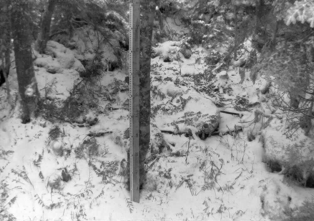
A shot of the famed Mt. Mansfield stake from today featuring the season’s first accumulating snow.
So, Oct 22 will go down as the date for our first accumulating Mt. Mansfield snow for the winter of 2023-2024, and we can now add it to the books and see how it compares to the averages. The stats for first accumulating snowfall of the season on Mt. Mansfield are below for comparison – today’s date of Oct 22 is later than the mean date of Oct 11, but well within 1 S.D., so quite normal in that regard. Assuming a normal distribution, about 25% of seasons will have later first snowfall dates than this one.
The dates of first accumulating Mt. Mansfield snow for some recent seasons are shown below as well, so this season sits later than the past few, but ahead of most of that stretch in the mid-2010s, which was a surprising run of later October dates.
Mean: 10/11
Median: 10/10
Mode: 10/17
S.D.: 15 days
N: 67
Most Recent: 10/22
Most Recent Days Deviation: +11
Most Recent # of S.D. Deviation: +0.732
Most Recent S.D. % Lower: 76.8%
Earliest 8/28/1986
Latest 11/17/1985
Date of first accumulating Mt. Mansfield snow by season:
2008: Oct 3
2009: Sep 30
2010: Oct 7
2011: Oct 30
2012: Oct 8
2013: Oct 24
2014: Oct 26
2015: Oct 17
2016: Oct 26
2017: Oct 27
2018: Oct 13
2019: Oct 18
2020: Oct 17
2021: Oct 18
2022: Oct 8
2023: Oct 22
There’s apparently a Nor’easter brewing for this weekend, although there’s not a ton of cold air around for the system to use, so the current forecast suggest snow will only be up near the summit elevations and fairly limited in amount.
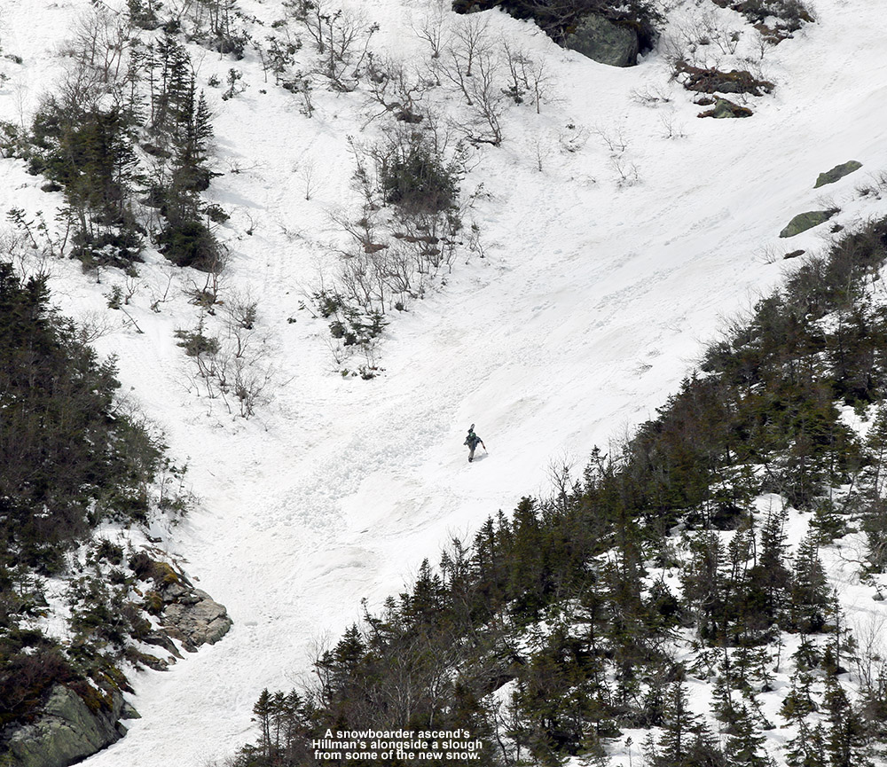
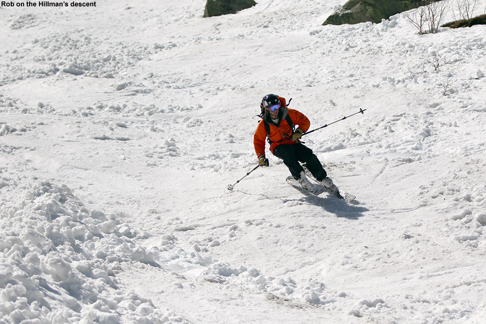
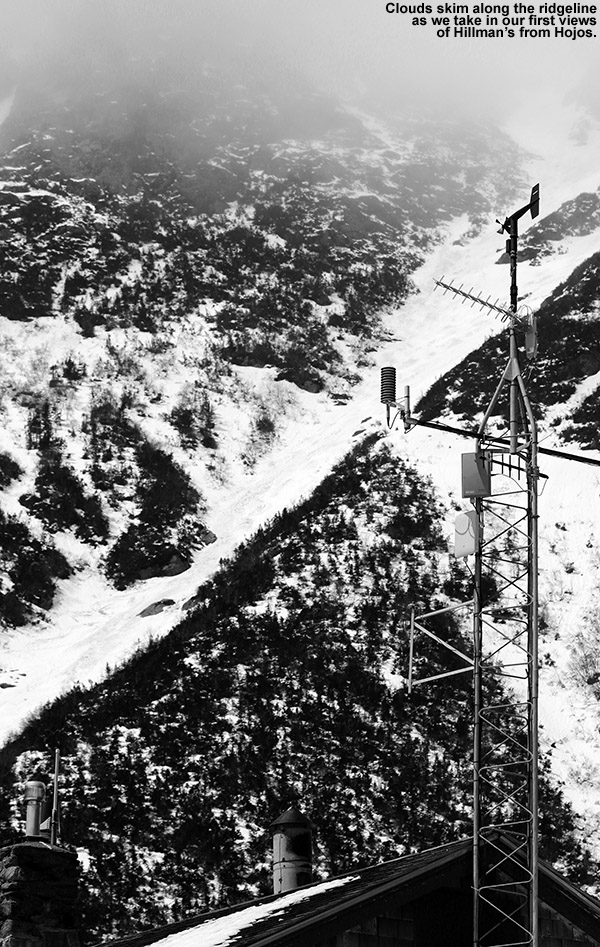
Hillman’s Highway was the choice today for our trip to Mt. Washington
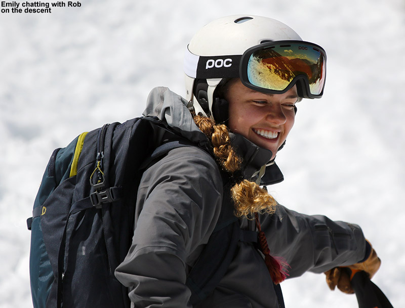
As the spring semester winds down, many of our graduating biochemistry majors here at UVM have been getting out to enjoy the remaining snow in the mountains of both New Hampshire and Vermont. I’ve been hearing some fun reports, so when Rob invited me to join one of their Mt Washington adventures, I was definitely interested. His plan was for the Tuesday of senior week, weather permitting of course. My schedule looked good, so I was hopeful for the chance to commune with some of the seniors in the great outdoors before they’d begin departing after graduation.
“We could see that there had been some sloughing there due to the new snow, but the lower areas we could see looked quite settled and stable, and there had already been plenty of skier traffic in the gully.”
Mother Nature threw some rather interesting weather into the mix ahead of the planned trip, with Mt Washington picking up almost 3 feet of new snow at summit elevations over the past couple of days, and over a foot down at Hermit Lake. That was a lot of new snow, and the avalanche report suggest that northerly winds would be loading the more southerly-facing gullies and cross-loading the east-facing ones. Temperatures were expected to rise significantly today, which we knew would result in plenty of settling depending on elevation. There seemed to be enough potential to find at least some level of safe skiing, so we decided that we’d check with the staff on scene in the Hermit Lake area, and the trip was on.
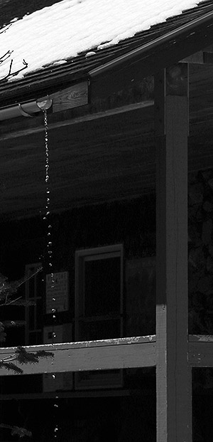
Meltwater pours from a gutter at the Hermit Lake Caretaker’s Cabin as rising temperatures melt off the recent snow.
Only Rob and Emily ended up being able to make the trip, but I met them at the Pinkham Notch Visitor’s Center, and after getting our gear together, we were on our way. I’ve hiked up to the Tuckerman Ravine area many times, but with the new snow I decided to try a gear setup that I’ve never used before. Instead of brining two pairs of boots (hiking boots and ski boots), I wanted to just wear my mid-weight Telemark boots for everything, hiking and skiing. It turns out that the setup worked great; my Garmont Gara boots have got rubber Vibram soles so they were plenty comfortable and pliable on the ascent through a lot of dry, rocky terrain. Ascending from Pinkham Notch at ~2,000’, we saw our first signs of snow at 2,650’, and at around 3,400’ the snow cover was continuous enough that I was able to start skinning there and made it right up to Hermit Lake. The new foot or so of snow had certainly helped with the potential for skinning – coverage would have been somewhat less continuous on that last part of the ascent without it.
We assessed the snow/ski terrain situation from there, and while most of Hillman’s was visible with clouds just skimming the upper reaches, Tuckerman Ravine was generally socked in. After consulting with the staff at Hermit Lake, and using what we could see, we decided that Hillman’s Highway was the way to go. Most skiers we encountered seemed to be making the same decision. We could see that there had been some sloughing there due to the new snow, but the lower areas we could see looked quite settled and stable, and there had already been plenty of skier traffic in the gully.
Hillman’s Highway from the Hermit Lake area
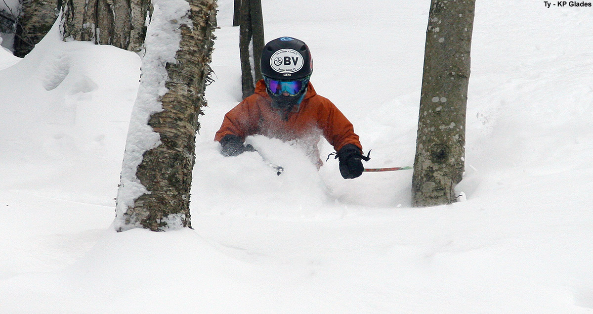
Emily and I skinned up the first part of gully, but around halfway it was just getting too steep and we had to switch to hiking. Thankfully there was a nice boot ladder already in place on climber’s right. I stopped around mid-gully where I figured I’d still get plenty of descent, and set myself in a good position with my camera. Emily and Rob headed up to where the gully splits into a Y, and went a little farther up the climber’s right option before settling down in a sheltered area of rocks. Above that point the snow hadn’t been skied and was a little questionable, and in that regard they were on the same page as other folks skiing in the area.
The best skiing was in areas where there had been some skier traffic that got down to the older corn snow surface, and the toughest turns were in the mush that had settled down near the bottom of the gully. The Sherburne Ski Trail had actually opened back up a bit with the new snow, and we were able to ski about a third of it before we had to cut back to the hiking trail. After that the descent was quick, and we were back at the cars saying our goodbyes.
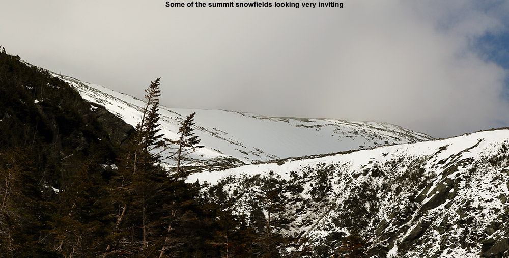
A view of the summit snowfields of Mt. Washington from Hillman’s Highway after almost 3 feet of snow in the past few days
The new snow is going to get even better with a couple of freeze-thaw cycles, and it’s certainly bolstered the snowpack somewhat in the higher elevations. Although they were in and out of the clouds, the summit snowfields looked really nice, so there should eventually be some excellent skiing up there with easy access as soon as the road opens back up.
We’ve been hearing mentions of snow in the recent weather forecasts, mostly about how we’re getting close to those temperatures where the mountains can start to see flakes, and today I saw the first reports of snow up in the higher elevations. One of the engineers manning the broadcast equipment up on Mt. Mansfield snapped a picture of some of the flakes falling to document the first Vermont snow of the season. It’s not too surprising, with Mt. Mansfield close to the freezing mark this morning along the ridge line. A bit higher up, the summit of Mt. Washington in New Hampshire is sub freezing at this point. It’s October now, and although it looks like we’ll have plenty of nice weather coming over the next week, it’s the time of year when the mountains can start getting snow at any time, so we’ll be on the lookout for upcoming snow chances.
Since the end of the school year was keeping E rather busy last weekend, the boys and I just made a quick day trip out to ski the Mt Washington snowfields on Sunday. The turns were good, and with things lightening up for E by this weekend, we again kept our eyes on the weather for some possible camping and skiing. The forecast ultimately looked even better than it did for last weekend, suggesting warm, dry weather both Saturday and Sunday, so we packed up and headed off to New Hampshire yesterday around midday.
“…Ty started banging out runs pretty quickly on that upper section because he really liked the short hike back up.”
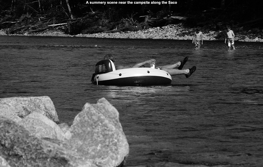
We set a course for the Glen, NH area to see if we could get a site at the Glen Ellis Family Campground similar to what we’d had last spring. We’d never been to the campground before that trip, but we really liked the riverside campsite we had along the beautiful Saco River. Since the Sunday forecast looked even a bit better than Saturday with respect to the potential for clouds and wind, we headed right to the campground yesterday and found that they had a number of the riverside campsites available, even ones with electrical power, which we find great for charging up various mobile devices. It was a warm afternoon in the 80s F, and tubing on the river was a popular activity. They’ve really got a great setup there for running laps in the river; you just ride down as far as you want, and walk your tube back up along the edge of the campground. We spent a chunk of the afternoon working on Dylan’s throws and playing some disc golf in the campground’s massive grassy fields. After we’d spent so much time practicing, it was great to see how often Dylan was able to hit the disc golf basket. We then had dinner at the campsite, and finished off the day with some evening exploration of the shoals and islands in the river. Dylan discovered that the campground had Wi-Fi, and we had an excellent signal even all the way out by the river, which is almost a half mile away from the main office. They must have an impressive wireless setup to be able to span the 65 acres of their campground. I did a test on Speedtest.net and found that the upload and download speeds were both 1.0 Mbps, which is plenty of bandwidth unless you need to stream video or do something similarly intensive.
Enjoying the views along the Saco River
This morning we had breakfast, gradually broke down the campsite, and headed north on Route 16 for the quick trip to the Mt Washington Auto Road. Thanks to the available Wi-Fi at the campsite, I was able to do a check on the Ravines Cam to see the current state of the snowfields. It was clear that the main Ball Crag Snowfield had lost a lot of snow in its middle sections, and the snow had the look of a backwards letter “C”. The main area of the East Snowfields had broken up a lot, such that largest remaining section didn’t seem to have much more vertical than what seemed available on the Ball Crag Snowfield. With that information and our knowledge from last week about the ease of access, we decided that the Ball Crag Snowfield area was still probably the best bet for today’s trip. After reading another trip report at the Time For Tuckerman Forum last week in which someone monitored their gas mileage up the Auto Road, we decided to monitor ours, and found that it was right around 9.0 MPG up to the 5,700′ parking area in the Subaru; since the other report indicated that they managed 10 MPG in a hybrid vehicle, and we were loaded with four passengers and lots of camping and ski gear, I guess that’s not too bad. Presumably there’s not much gained in a hybrid on a long, continuous climb like the Auto Road, but whatever vehicle it was, it’s likely to be a fuel efficient one anyway. As we unloaded our gear, one of the Mt Washington Auto Road Coaches passed by, and the driver reminded us to make sure we stayed on the rocks so that we didn’t harm any of the fragile alpine flowers and other vegetation. I hadn’t seen much vegetation flowering last week, but he noted that some of the flowers were just starting to make their way up to these elevations now. It actually wasn’t as sunny as we thought it might be, and gray clouds almost looked like they might throw down some precipitation, so everyone packed light shells in their packs just in case. Being just a few minutes from the car, we find that one can pack minimally if they want to, but if rain really came down, we’d want to have something on hand.
After missing last week, E was able to get out on the snow today.
It was again a short trip to the snowfield, and we could start to get a sense for how what the ski options were going to be. Since last week, we could see that there hadn’t been too much change in the areal snow coverage in the upper section of the snowfield, but the lower section showed dramatic differences due to the past week’s melting. The lower section was much smaller, and the snow was no longer continuous into that area. That made laps in the upper section most practical, and Ty started banging out runs pretty quickly on that upper section because he really liked the short hike back up. E slid out a bit on her first run and even got into the rocks at the bottom, but she was OK – it was definitely the most dramatic encounter with the rocks we’ve seen though, even more than when Dylan got into them a little bit last week. We often talk about how much we really need our helmets on these outings on the snowfields, since there are rarely other skiers around, but E’s slide was another great example of why we make sure to wear them. As she was sliding, even though she was in good shape being feet first, she was very happy to know that she had that helmet on. Ty kept cranking out the runs, and even Dylan whipped out a couple of quick runs before taking a break. I started to make some runs to see if I could catch up to Ty, but every time I’d take a run, he would do another with me, so there was no catching up that way. He was having fun with that, knowing that as long as he did a run every time I did, there was no way that I’d be able to catch up. It made for some fun runs where he worked on mirroring my turns, and although I couldn’t see him while we were skiing, now that I look at some of the photos, I can see he was doing a really nice job. For our last run, Ty and I connected down to the lower snowfield for a few extra turns on our way to hike out, so in the end we called it an extra quarter run, so Ty wound up with 7 ¼ runs to my 4 ¼ runs, with Dylan at 3 runs and E at 2 runs. We joked with Ty that he didn’t even do as many runs as the rest of us, because before that last run, he was quite proud that he had! The sky remained with one and off gray and sometimes fluffier clouds, with the occasional break of sun, and fortunately there were no signs of any precipitation.
The boys had wanted to head up to the summit of Mt Washington and visit the Sherman Adams Summit Building on our last outing, and we didn’t really have time, but this time we’d planned on it, so we stopped in at the visitor’s center for a while. We used our tickets to the new exhibit area in the museum, which is focused on the extreme nature of Mt Washington in the winter, and indeed it has been heavily updated relative to what was there before. The whole area seems very new and modernized all around, and there’s some impressive use of high-definition screens and other video technologies. It’s certainly worth a visit to the new exhibit if you have not seen it since it’s opening in May. We stopped in Gorham for a bite on the way home, and ate at one of the picnic benches on the Gorham Town Common, where the boys hit the playground for a bit. I’d say that’s just about it for the snowfields this season, so most of the activity will be shifting to Tuckerman Ravine. For some strange reason, the availability of snow only seems to decrease this time of year!
Dylan out on the snow today among some of Mt. Washington’s massive boulders
Last weekend’s weather was a bit too dicey to get us to head over to Mt. Washington for skiing, but the forecast for good weather this weekend was looking pretty solid. E was feeling the need to get other work done with the end of the school year closing in, so the boys and I decided to just go for a day trip to the snowfields. Typically we throw in some camping in the White Mountains as part of our Mt. Washington ski trips, so this would be the first time in a while that we’d be doing the out and back in a day. It’s actually just a couple hour trip to get over to the base of the Mt. Washington Auto Road from our place in Waterbury, so day tripping is certainly practical, but breaking up the driving with some camping has been the routine these past few seasons.
“The snow was great, being a bit harder in a few spots, and a bit softer in others, but the bulk of it was just right for making turns.”
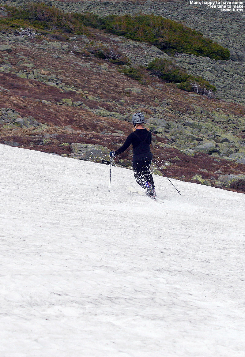
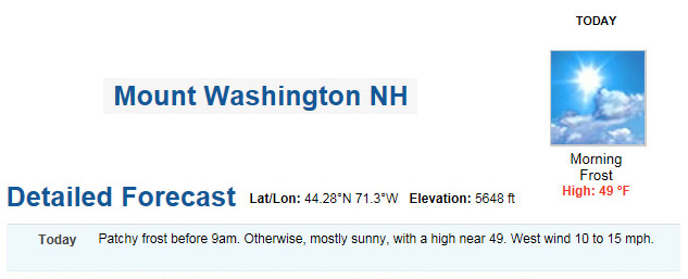
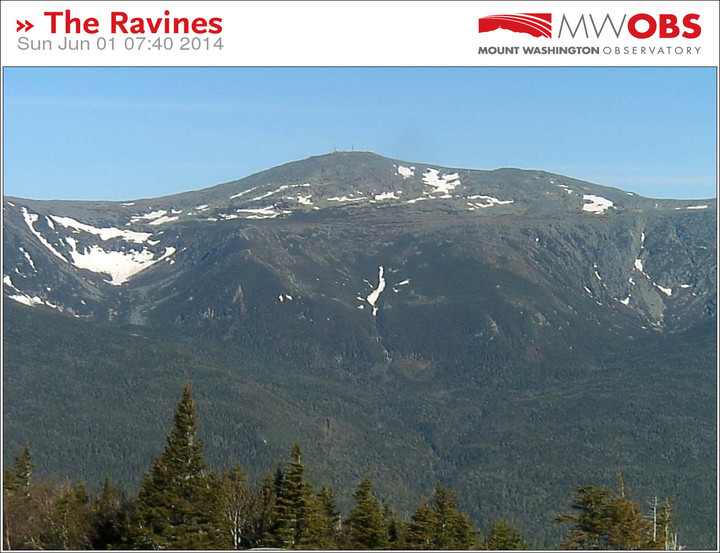
I did a final check on the forecast for roughly the 5,500’ level on Mt. Washington this morning, and it called for leftover frost, clear skies, a high around 50 F, and light winds in the 10-15 MPH range. That’s an excellent forecast for some skiing in Mt. Washington’s alpine areas, and it’s good to jump at these sorts of days, because you never know what the next one will bring when it comes to the Mt. Washington and the Presidential Range. The boys and I headed out around 9:00 A.M. under blue skies and temperatures in the 60s F, and by midday we were up in the parking lot along the Nelson Crag Trail at ~5,700’ getting our gear together. The weather was great, and the numbers on the board showing the summit weather conditions had been right in line with what the forecast suggested. After checking the images from the Ravines Cam over the past few days, as well as this morning, I could see that one of our favorite snowfield areas below Ball Crag was of decent size, so that was our planned destination. We like that Ball Crag snowfield because it doesn’t see nearly as many visitors as the main East Snowfields below the summit, and instead of having to park above it and hike down into the snow, you can contour right across from the parking area along the Nelson Crag Trail. It can be a bit harder to find some of those lower snowfields if you’re not familiar with the area, but we usually have good luck traversing out from near the junction of the Nelson Crag and Huntington Ravine Trails.
Checking the Ravines Cam this morning to orient ourselves to the available snowfields
“The snowfield was a totally clean slate of corn, with no traces of previous skier activity…”
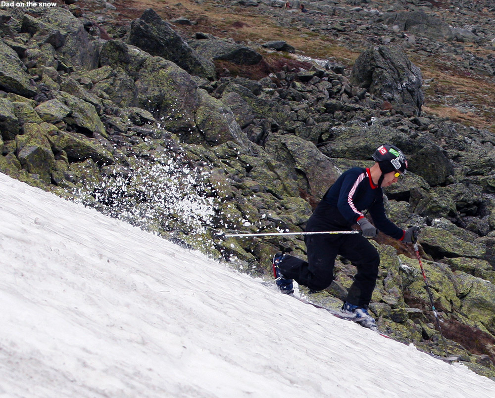
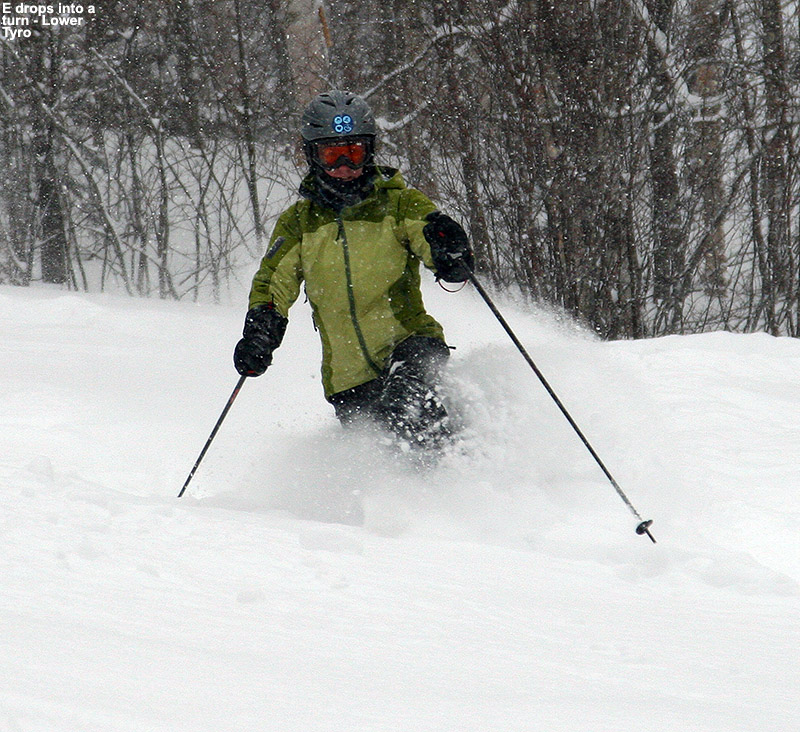
Today the traverse out to the snowfield was incredibly quick – within 5 to 10 minutes (Ty says it was 7 minutes) we’d hit the snow. The snowfield was a totally clean slate of corn, with no traces of previous skier activity, so presumably nobody had skied it in a while. The scene was quiet when we arrived, but it wasn’t long before the boys started having fun with the snow and the activity level ramped up. The boys had a great attitude about the skiing today, certainly relative to some trips we’ve had, and although it was different since Mom wasn’t there, I think they enjoyed the “boy’s day out” sort of feel. We made an initial ski descent of the snowfield, which seemed to provide somewhere in the range of 200 feet of vertical. It was a reasonably long run in which you could certainly get a groove going, and there were a lot of different options for skiing in the various nooks and crannies of the snowfield’s footprint. The snow was great, being a bit harder in a few spots, and a bit softer in others, but the bulk of it was just right for making turns. I told the boys that I’d bring their skis back up for them so that they could enjoy the hike, and strapped their skis on my pack along with mine. It actually wasn’t a bad pack load, and I think it helped to keep their spirits up.
Part of today’s terrain
Back at the top of the snowfield, we had lunch, and the boys again played around in the snow for a while. There was just a bit of breeze at times, and bugs were virtually nonexistent, so it was a great day to be out on the snow. During our first run, a couple with a dog had arrived for some skiing, but they spent their time a little farther over on the snowfield, so we didn’t see them much. It was actually good that they had their own section in which to hang out, because Ty and Dylan were a bit boisterous in their play, and that way the boys weren’t too loud in their immediate vicinity. For our last run we decided to run out the snowfield to the bottom, then contour back over to the Huntington Ravine Trail and take that right back up to the car. That hike took a bit longer since we were starting out lower in elevation, but I’d say within roughly 15 minutes we were back at the parking area. The boys still played around a lot today, so that took up plenty of the afternoon, but this has to be our most efficient outing in terms of the hiking. The snow will likely be around for a bit longer based on what we saw, so there should be snowfield turns available for those that are interested as we move forward in June.
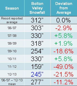
Snowfall: Compared to the snowfall-deficient 2011-2012 Ski Season, the 2012-2013 Ski Season was certainly a step up, but it was still generally below average for snowfall in the mountains of Northern Vermont. It was Bolton Valley that seemed to fare the worst of the northern resorts along the spine of the Green Mountains, perhaps due to their west slope location and this season’s dearth of upslope snow; they reported just 78.5% of their average snowfall. Heading northward, Stowe and Smugg’s fared a bit better at around 85% of average, and Jay Peak reported roughly average snowfall. Down at our house in the Winooski Valley, snowfall was 88.6% of average, so not too shabby by most accounts, but a bit below the mean like some of the local mountains. These past two seasons have actually been the first pair delivering back-to-back below average snowfall in our area since we started keeping track in 2006. Those numbers can be seen in both our Waterbury Winter Weather Summary Table, and the table of Bolton Valley annual snowfall below; this past season’s snowfall is highlighted in blue:
Low snowfall last winter meant back to back seasons with below average snowfall at Bolton Valley.
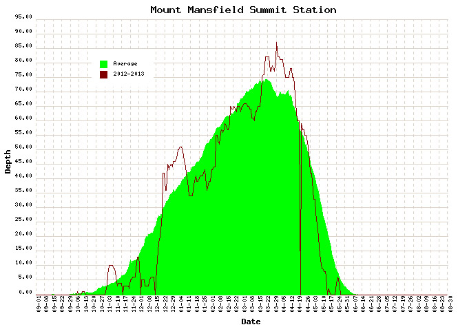
Snowpack: Aside from the spikes associated with a couple of early season storms, the mountain snowpack was below average going into mid December. That changed quickly though, with the onset of all that new snow during the second half of the month. The above average snowpack achieved during the holidays didn’t actually stay that way during January’s warmth and lack of storms. After consolidation, the snowpack generally trundled along at or below average through February’s continuation of relatively low snowfall. From mid February to mid March, the snowpack sat there essentially stagnant for an entire month; to wit, on February 21st, the snowpack was at 65”, and roughly a month later on March 18th, it was still at 65”, without any notable consolidation of more than a few inches. The late season stretch from mid March to mid April represented a nice rebound for the mountains however, with some quick gains from the big Northern New England March storm getting it above average, and the snow depth staying at least modestly above during the period.
Two periods stood out this past season for above average snowfall: The holiday period and mid-March through the end of April.
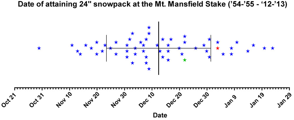
Tree Skiing: One metric used as a rough guide for the start of off piste skiing in the Northern Green Mountains is the point at which the snow depth reaches 24” at the Mt. Mansfield stake. For those unfamiliar with how this metric was established, it’s described in some detail in the 2011-2012 ski season summary. With the incorporation of this season’s data, the mean date remains at December 12th ± 19 days, with an average depth at the stake of 25.9 ± 2.7 inches. After the very slow start in 2011-2012, in which the 24” depth wasn’t attained until January 3rd (more than a standard deviation later than the mean), this past season was notably earlier. The plot below shows the date at which 24” was obtained for each season since 1954, with 2011-2012 shown in red, and 2012-2013 shown in green:
Each star marks the date of attaining a snow depth of 24 inches at the Mt. Mansfield stake, covering all years since 1954. Although still a bit later than average, reaching a depth of 24 inches at the stake this past season (green star – Dec 22) occurred much earlier than the previous season (red star – Jan 3). The mean date for attaining a depth of 24″ is marked by the large vertical bar in the center of the plot, and the smaller bars indicate the range of one standard deviation above and below that mean.
This past season, the date (December 22nd, Depth=28”, Green Star) was still later than average due in part to the slow first half of December, but unlike last season it was well within the 1 S.D. bars (thin vertical black lines). Note that the 24” mark is being used as an indicator of when the first forays into appropriate off piste/tree skiing terrain typically start in the Central and Northern Greens. In terms of empirical tree skiing observations, personal experience again lends some support to the use of 24” mark this season, as we began venturing into the trees the very next day on December 23rd at Bolton Valley. It should be noted though, that while the 24” mark was attained on December 22nd this season, the 40” mark was attained the very next day on December 23rd. The 40-inch rule (i.e. reaching a depth of 40” at the stake), is used as an indicator of when most off piste/tree skiing around here is ready to go. Although I haven’t looked into the data, this season has got to represent one of the quickest ascents from 24” to 40” – it’s interesting to note however that after rising to 42” of depth on December 23rd and 24th, the snowpack settled back to 36” for a couple of days before rebounding to 45” on the 27th.
Snow Quality: As an monitor of snow quality for the season, the chronological list of our ski outings has once again been compiled, with those days in which we were skiing powder indicated by a P, and those days in which powder skiing wasn’t available indicated by an X. The availability of powder suggests a fairly high level of snow quality, and the absence of powder generally indicates that temperatures rose above freezing at all elevations. Each listing below represents a link to the full report where images and more information from the outing can be obtained. Outings with an X may still be providing decent skiing such as wet snow, corn, etc. (or else skiing was typically avoided) but aside from the spring period, there’s going to be a price to pay in terms of snow quality associated with these episodes when temperatures eventually cool back down. The pattern of snow conditions in the Northern Green Mountains was fairly typical this past winter, with those days lacking powder skiing showing up in three distinct periods: 1) the early season with its usual temperature fluctuations, up through mid December before the weather pattern changed and the cold weather stabilized, 2) a thaw period in mid January, and 3) the period starting in mid March where spring weather began to make inroads. However, with the way the weather patterns this past spring continued to provide cool temperatures and snowfall, powder skiing generally dominated until mid April. Having analyzed the skiing in this way for the past three seasons, a surprising level of consistency is noted, with an overall average of close to four out of five days providing powder, despite notable differences in the demeanor of these recent ski seasons. The 2010-2011 season, which was above average in snowfall, provided powder on 78% of outings, the 2011-2012 season, which was well below average in many ways, revealed the same 78%, and most recently the 2012-2013 season, which was slightly below average in this area, produced a very similar 77% of outings with powder. The percentages don’t take into account differences in the number of outings each season, but with all three seasons falling into the range of 50 to 60 ski outings, differences in the sample sizes aren’t huge. The list of categorized ski outings with links to their full reports follows below:
The detailed month-by-month synopsis of the season is next:
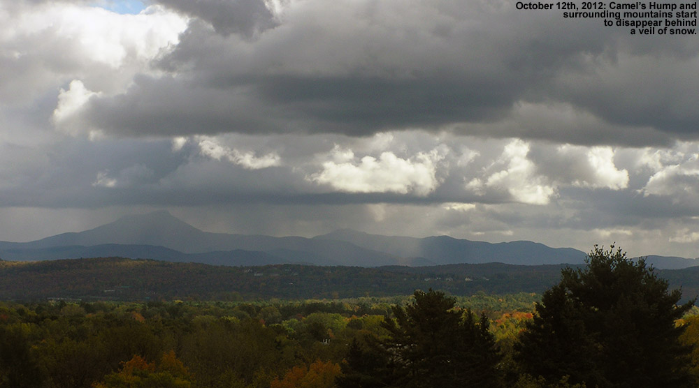
October: It wasn’t an especially snowy October to kick off the season; we had five rounds of snow in the mountains, and the third one even dropped accumulations to the lowest mountain valleys, but none of the storms were huge dumps, and we had just a tenth of an inch of snowfall down at the house for the month. October’s first snowstorm started up on the 7th, with snowfall being reported at the top of the Mt. Mansfield Toll Road in the afternoon, and by the next morning Powderfreak sent along his picture of 4” of accumulation at the top of the Stowe Gondola. I also got a shot of Mt. Mansfield later in the day with its first accumulation of the season. It didn’t seem like quite enough snow to tempt me out to ski, but the FIS boys hit the snow and provided a thorough report of the turns. The second storm delivered some accumulation on the 11th, with a snow line up around the 3,000’ level and less than an inch of snow found up on Mt. Mansfield. The third storm was the one that finally touched the lower valleys with some minimal accumulations, but in terms of mountain accumulations, I don’t think it was anything more than junkboarding material. The 4th (on the 14th of the month) and 5th (on the 16th of the month) storms of October also appeared to be pretty minimal and generally flew under the radar in terms of discussion. So while it wasn’t a great October for natural snow skiing (with nothing like the back-to-back larger storms at the end of October during the previous season), some folks made some turns and there were several smaller rounds of snow to keep the peaks white.
April: Despite the somewhat slow increases in the snowpack during the heart of the winter, the gains made during the latter half of March meant that the snowpack was at least modestly above average heading into April, and it quickly reached a peak of 87 inches at the Mt. Mansfield Stake when the first storm of the month dropped a foot of snow at Stowe on April 2nd. I was up at Bolton Valley that day for a ski tour, and I got to witness some impressive snowfall rates as the storm crashed into the higher elevations. The alpine terrain above tree line on Mt. Mansfield was in good shape, consistently providing excellent outings during that first part of the month. Cool temperatures with additional snow meant that the snowpack stayed at an above average level right through the month, and another storm on the 12th saw Ty and I enjoying close to a foot of dense powder out in the Bypass Chutes at Stowe on the 13th. The skiing gradually transitioned to full on spring conditions after that weekend as the active pattern waned, and an impressively long stretch of clear weather moved in and stuck around well into May.
May: For most of May, there wasn’t much to talk about in terms of new powder, especially with the extended period of incredibly clear weather that carried over from the end of April and lasted a fortnight, finally ending on the 10th of the month. There was some mighty fine spring skiing right through that period with all the sun and warm weather, even if it did cause the snowpack to decrease a bit faster than it otherwise might have. The tranquil period of warm weather allowed the Mt. Washington Auto Road to open on the 10th of the month as well (definitely on the early side), but since unsettled weather had just returned at that point, we didn’t get to make our spring pilgrimage to the snowfields until the 18th. To really cap the month off well, Northern New England and the Adirondacks were rewarded with a Nor’easter over Memorial Day Weekend, which delivered roughly 3 feet of powder to Whiteface and nearly 2 feet to Mt. Mansfield. Excellent powder turns were made while the valleys were almost fully leafed out for the spring. We didn’t actually head out for any June turns beyond that, but the skiing over Memorial Day Weekend had been so good that it hardly mattered – it was just a few short months until the snows of fall would be returning.
So what about the overall feel for the quality of the ski season in Northern Vermont? Well, much like the snowfall numbers suggest, it feels like it came in a bit below average, even if not horribly so. The mountain snowpack (as gauged by what was seen at the stake on Mt. Mansfield) had its ups and downs, and on balance it probably gets rated in a similar manner to what the slightly subpar snowfall would suggest. Being frequent Bolton Valley skiers and living down below the mountain in the Winooski Valley, our perspective might be skewed a bit downward with the resort receiving just 78.5% of their average snowfall. Having the north miss out somewhat on a couple of big regional storms, while watching a horrid valley snowpack (see the 2012-2013 Winter Weather Summary for details) that kept ski routes to the lower valley bottoms essentially off the table, certainly didn’t win the season any extra points. It seems that 2012-2013 ultimately sits in the lower half of ski seasons and won’t be remembered as anything epic, but it also appeared to hold onto a decent level of powder availability (77%) based on our experiences, and that means there was still a pretty decent amount of good skiing. The fact that even the poor 2011-2012 Ski Season was able to hold onto a powder percentage in that range is also reassuring in that regard, suggesting that there is indeed a certainly level of reliability that can be expected in these seasons where snowfall/snowpack is below average.


")

