
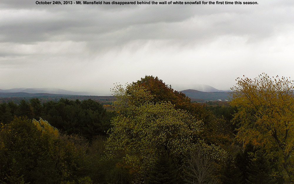
The appearance of snow in the higher elevations here in the Northeastern U.S. is definitely becoming more frequent as we approach November, and we’ve had two more rounds of Vermont snow in the past week. The first took place on the 26th as a low pressure system made its way across the area, with fairly high snow levels around 3,000′. Then the peaks were whitened again as of this morning with more snow. This latest event was also fairly warm, with snow levels up above 3,000′, but cold air is expected to come in as we enter November, dropping snow levels all the way to the lower mountain valleys. None of these systems have delivered snow amounts worthy of much more than junkboarding, but it’s been nice to have white in the peaks along with October’s foliage. It won’t be long before the snowfall amounts should increase and start to stick around for the winter.
Vermont snow levels lowering
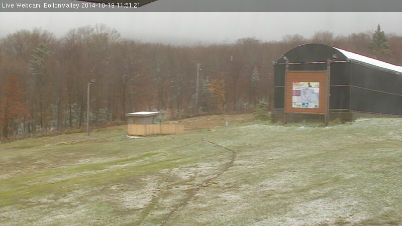
As the forecasts suggested, colder temperatures came into New England overnight, dropping freezing levels for another round of Vermont Snow. In the Northern New England thread at the American Weather Forum, Powderfreak contributed several pictures of the snow at Stowe, Eyewall provided some from Bolton Valley, and Borderwx added one from Jay Peak. Notable accumulations made it down all the way to 2,000’, which is the lowest so far this season. Some grainy snow even accumulated briefly on our picnic table down at our house at the 500’ in the Winooski Valley, and that’s just about average for picking up our first traces of snow at our location. I’ve added the text from my report to American Weather below:
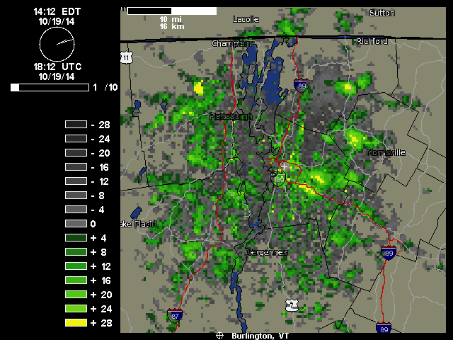
“We just documented our first frozen precipitation and accumulation of the season down here at 500’ in the valley. It started pouring out a few minutes ago as one of those bursts of precipitation came through in the northwest flow – you can see those yellow 28 db returns that disappear as the pulse of moisture barrels into the mountains:
Hearing the racket of the heavy precipitation outside, I decided to check out on the back deck because I know how these things sometimes go – indeed there was frozen precipitation among the rain, in the form of sleet and other dense granules that can typically make it down through the warmer layers of the atmosphere. I don’t even have my snowboard set up yet, but our picnic table out back sufficed to catch the accumulation. Seasonally, the timing of this event was right on track, with the mean for the first trace of snow here at Oct 20th from nine seasons of data. The event has actually brought the median value for that first trace of frozen down from Oct 21st to be right in line with that mean date of the 20th, and the S.D. dropped from seven days to six, so it’s helped to tighten up the data spread. The accumulation might have actually reached the 0.1” threshold for an official accumulation, but I was definitely caught off guard and by the time I grabbed my ruler and made measurements, all the accumulation was below that 0.1” mark so it will have to go down as a trace.”
Vermont Snow: First of the season
We’ve been hearing mentions of snow in the recent weather forecasts, mostly about how we’re getting close to those temperatures where the mountains can start to see flakes, and today I saw the first reports of snow up in the higher elevations. One of the engineers manning the broadcast equipment up on Mt. Mansfield snapped a picture of some of the flakes falling to document the first Vermont snow of the season. It’s not too surprising, with Mt. Mansfield close to the freezing mark this morning along the ridge line. A bit higher up, the summit of Mt. Washington in New Hampshire is sub freezing at this point. It’s October now, and although it looks like we’ll have plenty of nice weather coming over the next week, it’s the time of year when the mountains can start getting snow at any time, so we’ll be on the lookout for upcoming snow chances.
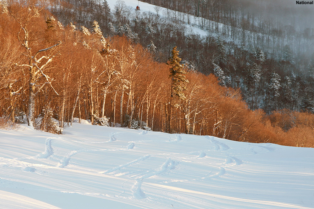
Stowe, VT 27OCT2013
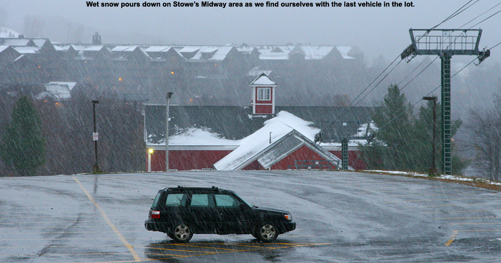
Dylan and E didn’t get to head out to the slopes yesterday, but after what Ty and I experienced, it seemed like it was worth heading back to Stowe for more. We were hoping that the quality of the snow would hold up, but rising temperatures were a concern – by late morning at our house, lengthy periods of sunshine had already pushed the temperature into the upper 40s F. If Stowe was encountering similar conditions, the freezing line, and the availability of reasonably dry snow, was going to rise way up in elevation.
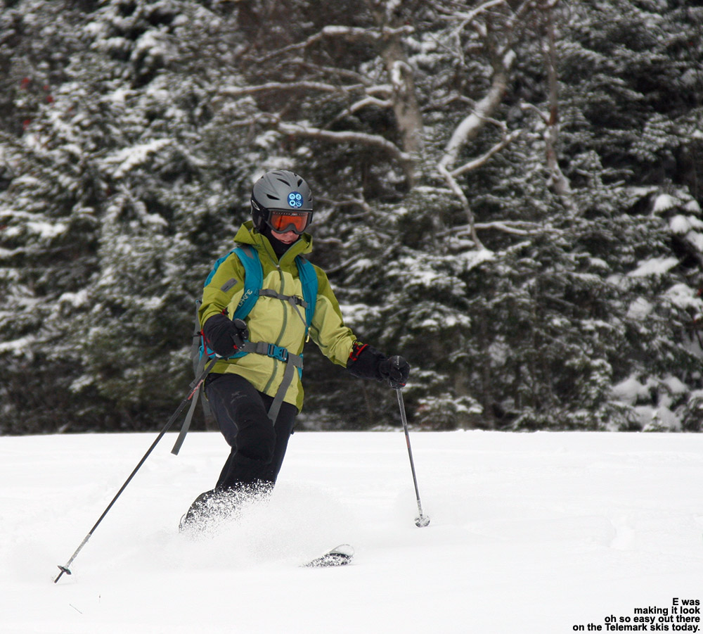
“…E was really putting
out some great turns on
her Teles. I was wishing
I could make Telemark
turns like hers today!”
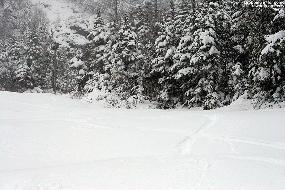
Fortunately, Old Man Winter was still playing around just to the north. The sun that we were encountering in Waterbury quickly faded behind clouds and increasing precipitation as we headed north through Waterbury Center, and by the time we were passing through Moscow, the temperature had dropped to 40 F and we were under moderate rainfall. Warmer temperatures overnight had definitely melted out some of the lower elevation snows; whereas yesterday we found the first signs of snow around 900’, today they were up around 1,300’ near the Toll House slopes. Snow had melted back a bit at the Midway Lot as well, and we had to walk a couple hundred feet up toward Perry Merrill before we could put on our skins. Temperatures were still quite cool there at 1,600’, in fact, at 37 F it was a degree cooler than what Ty and I had encountered when we’d arrived yesterday. The precipitation had also changed over to light snow.
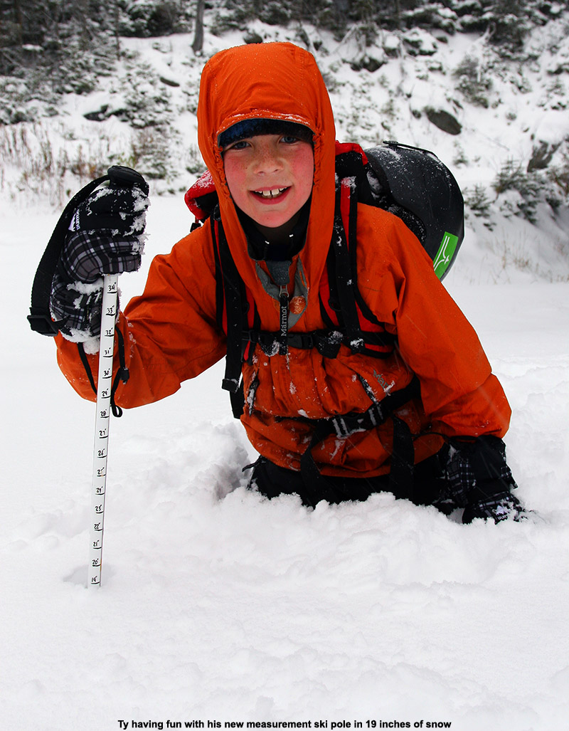
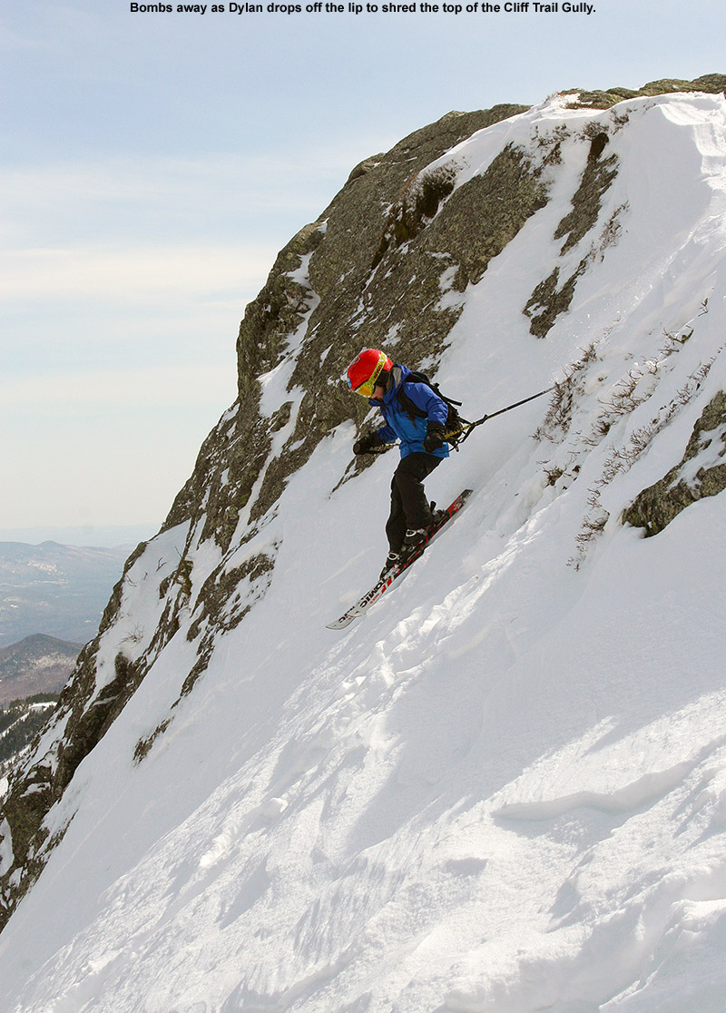
In order to let both boys go with their alpine skis as Ty had done yesterday, we gave them the Alpine Trekkers, and E and I used Telemark skis. We followed the same ascent route along Perry Merrill and Gondolier that Ty and I took yesterday. Once we got up around 2,500’, there was an excellent skin track along the climbers left of Gondolier, and it helped us make some good time. Dylan seemed to enjoy his ascent, getting his first chance to try out the Trekkers, and his first chance to try out his new Measurement Ski Pole. He was keeping up a great pace, and even as I was following along behind Ty at what seemed like a decent ascent speed, I was often surprised to look back and see Dylan right there nipping at my heels.
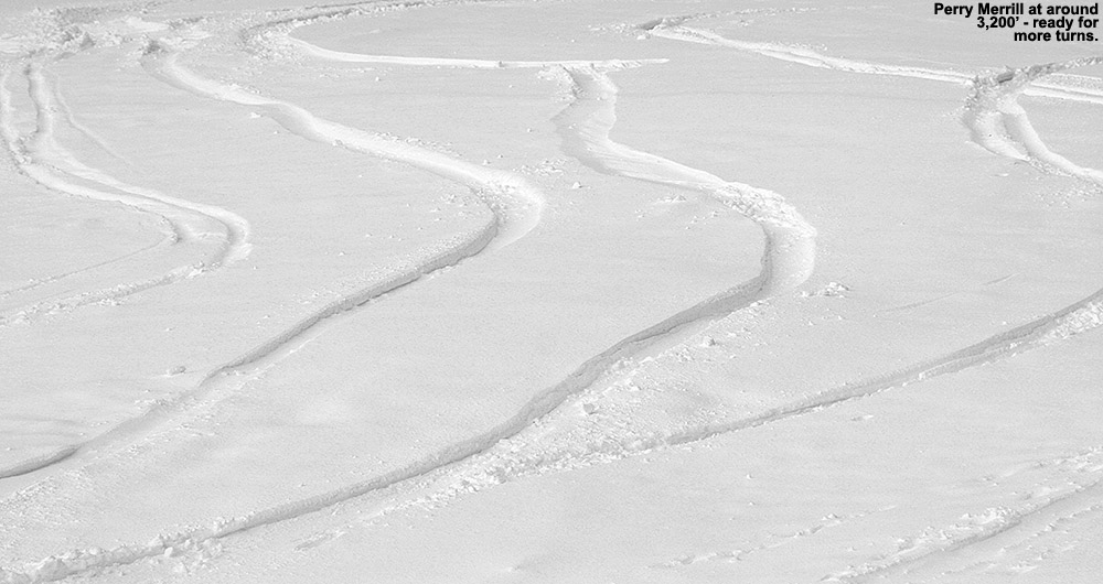
Although snow had definitely melted back somewhat in the lowest elevations, once we got up to around 2,000’, the snow depths actually seemed like they’d gained about an inch over what we’d found yesterday. We decided to stop our ascent at ~3,200’ on Perry Merrill based on what we saw for conditions above that and Dylan’s energy level, but we were well up into the dry snow by that point. Here are the typical snow depths that we found in the ascent, this time with three of us teaming up to contribute to the numbers:
1,600’: 0-2”
2,000’: 4-7”
2,500’: 7-9”
3,000’: 9-11”
3,200’: 11”+
As we took a break high on the mountain and got ready for the descent, we experienced notably different weather conditions than what Ty and I had dealt with yesterday. Gone was the pounding snowfall, we just had some clouds, and there were plenty of pockets of sunshine around. It was still below freezing up at that level however, so everyone made sure to quickly put on their extra layers before they chilled down after the hike. E got a call from Claire, who’d suspected that it was our car she’d seen at the base, and a conditions report was passed along.
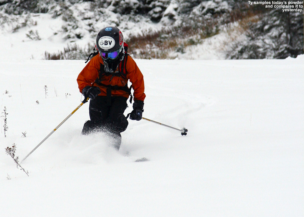
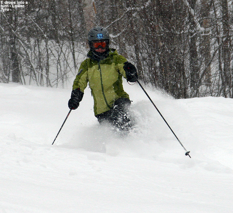
Once again, Perry Merrill looked good for the descent, so we took the route that Ty and I had used yesterday, especially since we had some good knowledge of the conditions. Ty really liked the conditions high up on the hill, while I think things were a step down from yesterday. The snow sort of transitioned from somewhat wind-affect, upside-down powder, to thicker, spring-like snow. I think that one less day of settling/weather affects, and the fresh snow that was falling, really helped to enhance things yesterday. We definitely got some good turns though, and there were plenty of fresh lines left to ski. I definitely had a more challenging descent that yesterday, switching from fat alpine skis to skinny Telemark skis, but E was really putting out some great turns on her Teles. I was wishing I could make Telemark turns like hers today! In later discussion, she was thinking that it might be all the extra support she’s getting from her new boots, and if that’s the case, they are definitely doing their job.
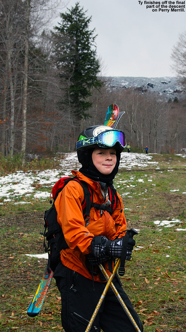 We decided to stop our ski descent at the 2,000’ mark, because the snow was just getting a little too thin for E and the boys to be continuing on their non-rock skis. It was a quick walk down back to the car into what was becoming a beautiful afternoon, and it was nothing like the maelstrom of wet snow that Ty and I had to deal with yesterday. Everyone felt like they’d gotten in a good workout, so a trip to The Whip was in order to finish off the evening. This October weekend has really marked a great start to the ski season, and we’re hoping there are more like it to come.
Stowe, VT 26OCT2013
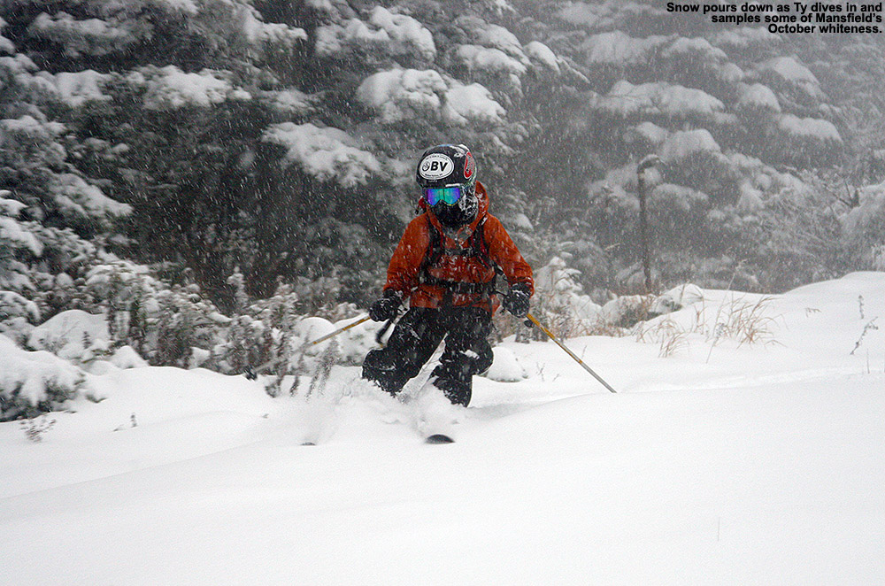
Well, we definitely got to witness Mt. Mansfield flexing the snowfall muscles today – despite the fact that we know this mountain’s ability to reel in snow, it just never gets old. Stowe delivers. I’d certainly been contemplating some turns, but after catching Powderfreak’s comment this morning about how it was dumping at the ski area, and then checking the web cams myself to see snow falling hard and fast at the base, that sealed the deal. Ty has been chomping at the bit for some skiing, so he joined me and we headed out in the early afternoon. Temperatures were in the low 40s F in the valleys, and the precipitation was generally light rain. The Worcester Range was visible to the east, white with new snow, but off to the west, a white haze hung over the spine of the Greens and we could see that it was definitely still snowing up there. The precipitation remained rain as we headed up the Mountain Road, but at ~900’ elevation near Northern Lights Lodge, we started to see leftover snow accumulations along the sides of the road. The snow on the ground continued to build, and by the time we pulled into Stowe’s Midway Lot at ~1,600’, we found 2-4” of snow on the ground up on the grassy slopes above. The temperature had only dropped to 38 F, but the precipitation had changed fully over to a light snow comprised of small flakes.
“…despite the fact that
we know this mountain’s
ability to reel in snow,
it just never gets old.”
We changed things up in terms of equipment today, and instead of Tele, we went with alpine gear using Alpine Trekkers for the ascent. I haven’t had the Trekkers out in a while, but it was time to bring them back into service; I’ve finally moved my old Volkl CMH Explosiv fat skis to rock ski status, and I was eager to try them out on one of these early days. My only Tele rock skis are my old skinny Rossignol Hellgates, and with a waist of just 70 mm, they’re really not a great tool for these early season powder days. Combining Tele + skinny + variable early season powder is certainly a recipe for challenge. Another reason to go with the Trekkers today was that Ty’s boots and bindings are now large enough to easily accommodate Trekkers. He’s not at the stage yet with his Tele skiing that he’s ripping up early season, potentially inconsistent powder with aplomb, so going alpine on the tour would be much more enjoyable for him. We decided to go with his carving skis instead of his powder skis for the setup, and fortunately we were able to get a good fit out of his skins from his Telemark skis.
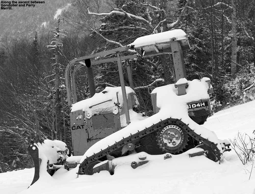 As usual, the Trekkers were great on the ascent. Although going with alpine skis and Trekkers is notably heavier than Tele, it’s typically not a big deal unless you’ve got huge tours to do. My biggest issue was with my skins – I’m not sure if the old skins for my CMH Explosivs have lost their water repellency, but whatever the case, today’s conditions had them catching and carrying a bunch of snow at times. I’d have Ty clean the underside of the skins off for me when we stopped, but we could never quite keep them from re-accumulating a coating of snow. Fortunately, Ty’s skins had no issues in that regard. The snow on the ground was quite wet at the base, but it dried out substantially as our elevation increased. We ascended via a bit of Perry Merrill, and then Gondolier to the Cliff House, and we observed the following snow depths with respect to elevation:
1,600’: 2-4”
2,000’: 4-6”
2,500’: 6-8”
3,000’: 8-10”
3,600’: 10-12”+
Aside from Ty’s first chance to try out Alpine Trekkers another new addition on this outing was his own Measurement Ski Pole. I put together measurement poles for both Ty and Dylan this fall, and it was great having Ty reporting depths along the ascent – with two observers we were able to collectively decide on the best approximations of depths to create the list shown above. It also kept Ty very interested in going higher, even if just to see how much deeper the snow was going to get. Although Dylan didn’t go out to the slopes today because he was off with E doing some shopping, based on Ty’s experience I think he’s going to have a lot of fun with the measurements on our next outing.
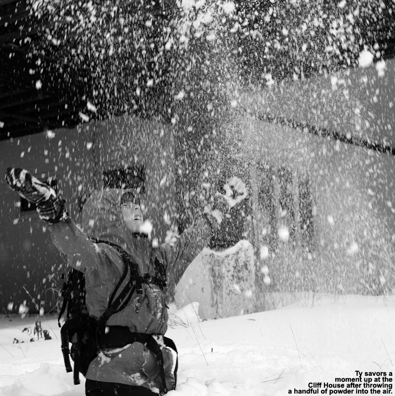
It was around 4:30 P.M. when we hit the top of the Gondola at ~3,600’, and the snow was coming down with some good intensity. It wasn’t quite inch an hour snowfall since the flakes were still fairly small, but it felt like it was somewhere between ½ and 1 inch/hr and it was quite impressive. We took shelter under the Cliff House to gear up for the descent because of the intensity of the snowfall, but there was almost no wind, so it was nice to hang out and watch the flakes pour down. With the late hour, thick clouds, and hefty snowfall, it had that dusky feel of December in the north. Ty and I discussed how it just as easily could have been December with all the snow. Another great milestone for Ty was the fact that this was his first full ascent to the Gondola, and it was nice to see that he still had plenty left in the tank at the top. We put a call in to Mom to let here know that we’d be descending soon, but also to let her know about Ty’s accomplishment.
We fueled up with some food and drink, but didn’t loiter too long because we knew the light was going, and we had to get in some shopping for dinner on the way home. Soon, we headed off down Perry Merrill, and one of the more challenging aspects wasn’t the snow, but the intense snowfall and reduced visibility. I’d been sort of soured on my CMH Explosivs the last time I’d used them, because they felt heavy and long and I just didn’t want to push them around, but today I’d say there was a newfound love for them. For whatever reason, perhaps because we were out on open trails instead of tight places, they felt great today – fat and stable, and just what one needs for the inconsistent early-season snow. Ty had to work hard on his skinnier skis to handle the powder, but we worked on technique on the way down and he made some great turns. I told him that if he could ski the powder on these skis, he’ll be cranking away when he’s on his powder skis.
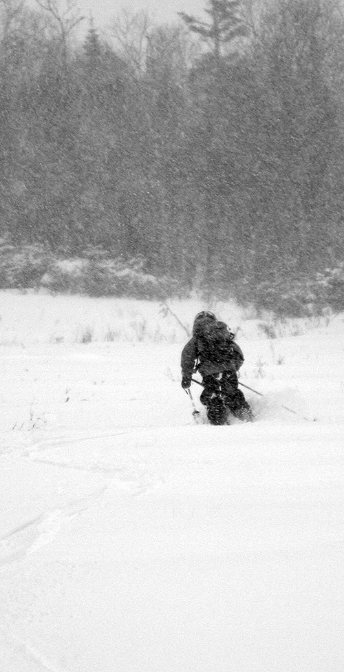 That more intense snowfall was with us on the entire descent, and the freezing line had gone down as well. Back at the car, heavy wet snow was falling, and the temperature was down to 35 F, three degrees below where it had been when we’d arrived. It was the sort of precipitation that soaked you very quickly once you were out of your Gore-Tex, and we both got pretty wet putting away the gear and switching out of clothing. The precipitation eventually changed back to rain as we dropped into the valleys on the drive home, but it was raining quite hard at times. There had already been some additional snow accumulations down to lower elevations by the time we were leaving, and the snow in some of the lower elevations actually looked better than it had on the way up due to some new covering. Overall the quality of the skiing was quite good, especially up high, and it could be even better tomorrow with more snow falling tonight.


Kicking off the snow season in Vermont
We’ve had a pleasant, mild, and relatively dry fall season so far in Vermont, and the only frozen precipitation of note was some ice back in September. That all changed this week however, as more seasonable temperatures moved in along with some moisture. Whereas the cooler weather can produce beautiful landscapes, it does make getting out an about a little more dangerous. You can’t plan for accidents but they can and do happen, especially in adverse weather conditions. Knowing first aid is one way to put your mind at ease. Why not consider a Brampton Cpr Training course, or one closer to home, where you can learn the basics of first aid? You might even save a life one day. Back to the weather for now though and the first reports of snow started to appear on Tuesday, with Jay Peak revealing some white accumulations, and by yesterday evening, Powderfreak sent in a picture of snow falling down to the 1,500’ base elevation of Stowe Mountain Resort. The snow levels really dropped overnight though, with reports coming in this morning of snow accumulations in some of the valleys. From there it was off to the races with updates as the world woke up, with more reports and pictures of snow in the local valleys and at the ski resorts. Around midday I saw snowfall descend on Mt. Mansfield, and there were some heavy bouts of snow captured on the web cams at Stowe Mountain Resort. Eyewall got a beautiful shot of the snow falling up at Bolton Valley, and Powderfreak posted nice images of the snow in Smuggler’s Notch and the base of the Stowe Gondola. Jay Peak even put together an artistic video of the falling snow, and it really gave you that feel of the season’s first event. As of this evening, the report from the Mt. Mansfield stake was indicating 3 inches of snow depth, but with the way it’s continued to snow this evening, there will likely be more out there by tomorrow. The forecast looks decent for additional snow this weekend as a clipper system moves through, and snow could continue even into next week. Killington opened with lift served skiing today, and if the forecasts are on track, I suspect we’re quickly going to see people out there on other mountains with sliding tools on their feet.
For an extended follow up on our October snows, head to the full report on the snow that affected the valleys on October 26th.
2012-2013 Waterbury Winter Weather Summary
The last snowstorm of the 2012-2013 winter season extended all the way out to Memorial Day weekend to produce some great late season skiing, but now that we’re well into summer and all the snow has melted, we can look back at how the winter went down at our location in Vermont’s Winooski Valley. The main focus in the seasonal analysis below is on snowfall, but snowpack and temperatures will be discussed as well. In this post I’ve hit on some of the highlights that came out of the data, and attached our various plots and graphs, but to get to the full data set, you can use the following link:
2012-2013 WINTER WEATHER SUMMARY
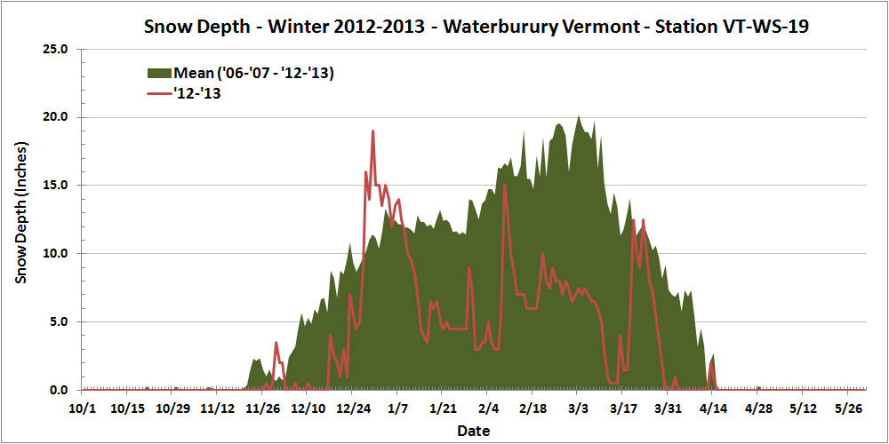
Thankfully, this past season’s snowfall (144.2″) marked a notable increase over the previous season (115.3″), but the total snowfall for 2012-2013 was still less than 90% of average, so that’s not likely to lift the season into the category of “great” winters. In addition, the amount of snow on the ground at the house last season didn’t help to improve the winter’s standing. Using the value of snow depth days as an integrative way of representing the season’s snowpack, one finds the 2012-2013 winter season producing a value of 729 inch-days, less than half the average value, and right down there in the basement with the well below average 2011-2012 season (688 inch-days). And, if the overall snowpack depth hadn’t already undermined any chances of redemption to an average level, the 2012-2013 snowpack secured the season’s ignominy by reaching the lowest value we’ve seen in January and February (3.0″), and coming within a hair’s breadth of melting out in the area around our measurement stake at a record early date in mid March:
Often, each month of the winter/snowfall season has its own unique flavor with respect to the weather, so one method I like to use to get a feel for the winter is to look at it on a month-by-month basis. Again, the focus below is on snowfall at our location, but snowpack is also considered, as well as mountain snowfall/snowpack and the associated effect on the local skiing. I’ll have a separate 2012-2013 ski season summary coming up, so I’ve kept the ski discussion minimal here in anticipation of a more thorough discussion in that report. The month’s total snowfall is listed at the start of each section below for reference:
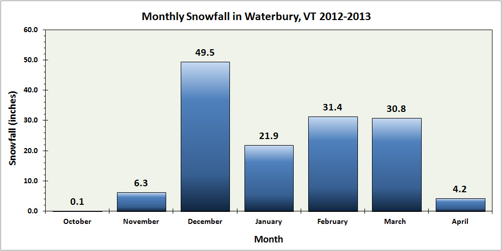
![]() Snowfall: 0.1″ – October snowfall isn’t reliable enough down at our elevation to be factored much into the seasonal assessment, but this October was on the weak side, with just a tenth of an inch of snow, vs. the mean of roughly an inch. Regardless of this, there was still enough for the needs of companies like https://divisionkangaroof.com/areas-served/gainesville/ with the weight of the snow causing damage to some roofs. One small feather in the cap of 2012-2013 is the fact that the first accumulating snow fell on October 12th, which beats out 2010-2011’s October 15th snowfall by three days, and now represents the earliest measurable snowfall I’ve recorded here at the house since I started monitoring the weather in 2006.
Snowfall: 0.1″ – October snowfall isn’t reliable enough down at our elevation to be factored much into the seasonal assessment, but this October was on the weak side, with just a tenth of an inch of snow, vs. the mean of roughly an inch. Regardless of this, there was still enough for the needs of companies like https://divisionkangaroof.com/areas-served/gainesville/ with the weight of the snow causing damage to some roofs. One small feather in the cap of 2012-2013 is the fact that the first accumulating snow fell on October 12th, which beats out 2010-2011’s October 15th snowfall by three days, and now represents the earliest measurable snowfall I’ve recorded here at the house since I started monitoring the weather in 2006.
![]() Snowfall: 6.3″ – November snowfall came in just a bit below average this past season, so certainly not remarkable, but notable in that it was probably about as average a November as we’ve seen. November has typically been feast or famine when it comes to snow. We actually had a total of five snowstorms in November, but a small to moderate storm of 4.4″ at the end of the month contributed the bulk of the monthly total as well as some of the first great skiing of the season in the mountains.
Snowfall: 6.3″ – November snowfall came in just a bit below average this past season, so certainly not remarkable, but notable in that it was probably about as average a November as we’ve seen. November has typically been feast or famine when it comes to snow. We actually had a total of five snowstorms in November, but a small to moderate storm of 4.4″ at the end of the month contributed the bulk of the monthly total as well as some of the first great skiing of the season in the mountains.
![]() Snowfall: 49.5″ – December held the first lengthy, redeeming snowfall period of 2012-2013. Although the first half of the month was extremely poor on snowfall (just 2.2″ of snow at the house), from the 16th of December onward, temperatures got cold and snow came in for a dramatic change; close to 50″ of snow fell on us in the second half of the month, and as a whole the month actually wound up several inches above average. Those in homes with faulty or no heating in place are likely to struggle with the crushing cold at this time of year which is why it’s so important to conduct regular maintenance on heaters so you’re not left to suffer over winter. Reaching out to the likes of these professionals could help with this – siriuspac.com/heating-repair-service/. A problem left unaddressed could snowball into substantial damage and become more costly to repair over time so it’s well worth acting on it as early as possible. We received our second (15.5″) and fourth (11.7″) largest storms of the season during that stretch, right near Christmas and just a few days apart, so needless to say, the snow was there to set quite the holiday mood in the valleys and up above on the slopes.
Snowfall: 49.5″ – December held the first lengthy, redeeming snowfall period of 2012-2013. Although the first half of the month was extremely poor on snowfall (just 2.2″ of snow at the house), from the 16th of December onward, temperatures got cold and snow came in for a dramatic change; close to 50″ of snow fell on us in the second half of the month, and as a whole the month actually wound up several inches above average. Those in homes with faulty or no heating in place are likely to struggle with the crushing cold at this time of year which is why it’s so important to conduct regular maintenance on heaters so you’re not left to suffer over winter. Reaching out to the likes of these professionals could help with this – siriuspac.com/heating-repair-service/. A problem left unaddressed could snowball into substantial damage and become more costly to repair over time so it’s well worth acting on it as early as possible. We received our second (15.5″) and fourth (11.7″) largest storms of the season during that stretch, right near Christmas and just a few days apart, so needless to say, the snow was there to set quite the holiday mood in the valleys and up above on the slopes.
![]() Snowfall: 21.9″ – January continued that good, snowy weather pattern in its first week, albeit to a lesser degree than December, but unfortunately that modest first week ultimately wound up representing roughly half of the month’s snowfall. The second week featured a couple of substantial thaws with no measurable snow, and in fact we received no accumulating snow at all for the period between January 7th and 16th, a very long stretch for the mountainous areas of Northern Vermont during the winter. The third week of January offered just a few small systems, and the fourth week was arctic cold with minimal snow. The final week attempted to recoup the losses with a modest half foot storm, but it was too little too late – the month ended with just 21.9″ of snow, by far the lowest January in my records. The combination of very low snowfall and two January thaws was very deleterious to the valley snowpack – after coming down from the depths achieved in December, the snowpack depth at our location never even reached 10 inches again during the month, and got as low as 3.0 inches. That is ridiculously close to losing the winter snowpack in January, definitely the closest we’ve come based on my records since 2006.
Snowfall: 21.9″ – January continued that good, snowy weather pattern in its first week, albeit to a lesser degree than December, but unfortunately that modest first week ultimately wound up representing roughly half of the month’s snowfall. The second week featured a couple of substantial thaws with no measurable snow, and in fact we received no accumulating snow at all for the period between January 7th and 16th, a very long stretch for the mountainous areas of Northern Vermont during the winter. The third week of January offered just a few small systems, and the fourth week was arctic cold with minimal snow. The final week attempted to recoup the losses with a modest half foot storm, but it was too little too late – the month ended with just 21.9″ of snow, by far the lowest January in my records. The combination of very low snowfall and two January thaws was very deleterious to the valley snowpack – after coming down from the depths achieved in December, the snowpack depth at our location never even reached 10 inches again during the month, and got as low as 3.0 inches. That is ridiculously close to losing the winter snowpack in January, definitely the closest we’ve come based on my records since 2006.
![]() Snowfall: 31.4″ – February was again below average in snowfall, partly due to the continuation of the dry arctic pattern in the first week, and it wound up missing the mark for the lowest February in my data set by less than an inch. Although that persistent dry pattern didn’t make for a very snowy first half of the month, our third largest storm of the season (12.6″) hit in the second week. It was still a rather modest storm, but at least it did break that one foot mark for accumulation at the house. By the end of the third week of February, the snow depth at the Mt. Mansfield stake actually poked above average for the first time in about a month and a half – but it was only by a couple of inches, and it quickly went back below average as the snowpack sat there essentially stagnant for an entire month. On February 21st, the snowpack was at 65″, and roughly a month later on March 18th, it was still at 65″, without any major consolidation of more than a few inches. That’s stagnant. Our snowpack at the house languished similarly, never even getting above 10 inches of depth during that stretch – and that’s a time of year when it is usually building to its peak of the season. The carryover of the low snowpack from January also set the lowest mark (3.0″) for snowpack that we’ve ever seen in February.
Snowfall: 31.4″ – February was again below average in snowfall, partly due to the continuation of the dry arctic pattern in the first week, and it wound up missing the mark for the lowest February in my data set by less than an inch. Although that persistent dry pattern didn’t make for a very snowy first half of the month, our third largest storm of the season (12.6″) hit in the second week. It was still a rather modest storm, but at least it did break that one foot mark for accumulation at the house. By the end of the third week of February, the snow depth at the Mt. Mansfield stake actually poked above average for the first time in about a month and a half – but it was only by a couple of inches, and it quickly went back below average as the snowpack sat there essentially stagnant for an entire month. On February 21st, the snowpack was at 65″, and roughly a month later on March 18th, it was still at 65″, without any major consolidation of more than a few inches. That’s stagnant. Our snowpack at the house languished similarly, never even getting above 10 inches of depth during that stretch – and that’s a time of year when it is usually building to its peak of the season. The carryover of the low snowpack from January also set the lowest mark (3.0″) for snowpack that we’ve ever seen in February.
![]() Snowfall: 30.8″ – Although certainly not approaching what we saw in the second half of December, the last part of the winter/snowfall season was the other relatively bright spot to mention. This was aided by our largest storm of the season, which delivered 21.3″ during the last third of the month. That storm was the only real standout for the month however. It did bring March above average in terms of snowfall, but only by roughly six inches, and the resulting monthly total really ranks in the middle of the pack for Marches in my records. The fact that the snowpack in the area around our snow measurement stake at the house was barely hanging on around mid month was certainly disconcerting, but the snowpack did recover somewhat with the help of a modest mid-month storm, that big storm at the end of the month, and reasonably cool temperatures.
Snowfall: 30.8″ – Although certainly not approaching what we saw in the second half of December, the last part of the winter/snowfall season was the other relatively bright spot to mention. This was aided by our largest storm of the season, which delivered 21.3″ during the last third of the month. That storm was the only real standout for the month however. It did bring March above average in terms of snowfall, but only by roughly six inches, and the resulting monthly total really ranks in the middle of the pack for Marches in my records. The fact that the snowpack in the area around our snow measurement stake at the house was barely hanging on around mid month was certainly disconcerting, but the snowpack did recover somewhat with the help of a modest mid-month storm, that big storm at the end of the month, and reasonably cool temperatures.
![]() Snowfall: 4.2″ – April was even a couple inches below average for snowfall, but temperatures stayed cool enough to keep the winter season rolling along, and that’s what really helped make the period wintrier. We didn’t have any notable April snow accumulations down at our elevation, just a couple of small ones on the 2nd, and again on the 12th – 13th, but the mountains continued to get fresh snow right into mid month to keep surfaces in great form and the Mt. Mansfield snowpack robust.
Snowfall: 4.2″ – April was even a couple inches below average for snowfall, but temperatures stayed cool enough to keep the winter season rolling along, and that’s what really helped make the period wintrier. We didn’t have any notable April snow accumulations down at our elevation, just a couple of small ones on the 2nd, and again on the 12th – 13th, but the mountains continued to get fresh snow right into mid month to keep surfaces in great form and the Mt. Mansfield snowpack robust.
![]() Snowfall: 0.0″ – There was no accumulating May snowfall down at the house this season, but that’s not too much of knock on the Month, because not getting snow in May is more the norm than actually getting snow. The mountains did get that beautiful Memorial Day weekend storm though, and the late season powder skiing was mighty fine. Although I can’t factor that directly into the analysis for the valley, it was quite cold in the valleys at the end of the month, and close to even snowing there.
Snowfall: 0.0″ – There was no accumulating May snowfall down at the house this season, but that’s not too much of knock on the Month, because not getting snow in May is more the norm than actually getting snow. The mountains did get that beautiful Memorial Day weekend storm though, and the late season powder skiing was mighty fine. Although I can’t factor that directly into the analysis for the valley, it was quite cold in the valleys at the end of the month, and close to even snowing there.
There were a couple of other interesting notes with respect to snowfall this season:
1) Storm frequency and average storm size: Despite coming in below average for snowfall, the 2012-2013 season offered up a healthy 51 accumulating snowstorms, almost up there with the 53 storms we received in 2007-2008. Of course, to come in below average for snowfall with that many storms indicates that the average snowfall per storm was down, and indeed it was. At 2.8″/storm, 2012-2013 ranks down there with 2011-2012 (2.6″/storm), the only odd seasons out compared to the more typical seasons up near 4″/storm. For whatever reason, this season’s average came in on the low side. This is presumably due in part to many of the everyday events being on the small side, but also due to the lack of bigger storms, which is covered in point #2 below.
2) Storms with double-digit snowfall: It’s certainly an arbitrary and subtle distinction, but after looking through my data, I noticed an interesting trend with respect to each season’s largest storms for our location. In my season summaries, I always make a list of the top five storms of the season, and when the season seems to have gone well, all of those top five storms have been in the double digits for snowfall. In fact, the “best” seasons thus far have been able to surpass that five-storm threshold. For reference, here’s the top five list for this season, with the links to the detailed web pages for each storm:
Top five snowfall events
1. 21.3″ (3/19/2013-3/24/2013)
2. 15.5″ (12/26/2012-12/28/2012)
3. 12.6″ (2/8/2013-2/9/2013)
4. 11.7″ (12/21/2012-12/23/2012)
5. 7.8″ (12/29/2012-12/30/2012)
Indeed, if we look at the number of storms with double-digit snowfall by the seasons, we see an obvious trend. With the number of double-digit snowfall storms listed in parentheses after the season, one notes those “good” seasons – 2007-2008 (6), 2008-2009 (7), 2010-2011 (7) seemed to find a way to exceed five double-digit storms, whereas the poorer snowfall seasons – 2006-2007 (4), 2009-2010 (2), 2011-2012 (3), 2012-2013 (4) just didn’t. Surely the law of averages comes into play here to some degree – seasons with patterns producing lots of snow likely have a greater chance of getting a big storm in here, but that’s not a given. It’s also very suspicious that those seasons that come in sort of in that middling ground like 2006-2007 and our season of interest for this summary, 2012-2013, fall just short of making the cut. I suspect this trend may be more intact in a location like ours because of the relatively high number of storms and snowfall, and upslope snow (which was on the low side this season) as an extra protection against huge snowfall variance, but this is going to be an interesting trend to follow into the future as a gauge of snowfall seasons.
In sum, while snowfall was certainly a bit below average, and snowpack was well below average, I’d still give the season a reasonable grade. If C is average, I’d go with a C- for 2012-2013, just a bit off from making the average. Were snowpack a more significant factor in my winter preferences, one could argue for going a bit lower, but at least minimal snowpack was maintained throughout the entirety of the winter to keep everything white. Overall it could have been a lot worse, and with the amount of snowfall we did get, it’s hard to drop the season into the D range, which, based solely on snowfall and snowpack at the house, is where I’d put a season like 2011-2012.
For a complete look at all the data, charts, graphs, and tables from the winter season, head to our Waterbury, VT 2012-2013 winter weather and snowfall summary page.


2012-2013 Ski Season Summary
Our recently completed 2012-2013 Waterbury Winter Weather Summary, focused on how the snowfall and other aspects of winter transpired down at our house in the Winooski Valley, and now this report will focus on the skiing and snow in the higher elevations.
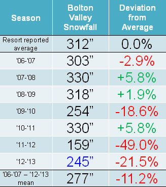
Snowfall: Compared to the snowfall-deficient 2011-2012 Ski Season, the 2012-2013 Ski Season was certainly a step up, but it was still generally below average for snowfall in the mountains of Northern Vermont. It was Bolton Valley that seemed to fare the worst of the northern resorts along the spine of the Green Mountains, perhaps due to their west slope location and this season’s dearth of upslope snow; they reported just 78.5% of their average snowfall. Heading northward, Stowe and Smugg’s fared a bit better at around 85% of average, and Jay Peak reported roughly average snowfall. Down at our house in the Winooski Valley, snowfall was 88.6% of average, so not too shabby by most accounts, but a bit below the mean like some of the local mountains. These past two seasons have actually been the first pair delivering back-to-back below average snowfall in our area since we started keeping track in 2006. Those numbers can be seen in both our Waterbury Winter Weather Summary Table, and the table of Bolton Valley annual snowfall below; this past season’s snowfall is highlighted in blue:
One item of note this season was the lack of big storms targeting Northern New England – two of the largest storms to hit the Northeast dropped the bulk of their payloads south of Vermont while exiting stage right toward the Atlantic. The first of those, nicknamed “Nemo”, hit in the second week of February, and pounded Southern New England with up to 40 inches of snow. The Green Mountains were on the northern fringe of that storm, but still wound up with 1 to 1.5 feet of snow up and down the spine. The other storm of note was during the March 5th – 8th period, and it dropped another 30 inches on some Southern New England locations, but nothing way up north. There were some periods of snowfall to highlight up in Northern Vermont however. The second half of December alone dropped almost 50” of snow down at our house, significantly more in the mountains, and produced some fantastic skiing for the holidays and into early January. Another period of note was the second half of March into April. Cold temperatures in the latter part of the season helped preserve wintry conditions on the slopes, and we received some decent snowfall as well – the largest storm for the season in my valley records hit the area near the end of March, with 21.3” of snow down at the house, and multiple feet for the mountains. The mountain snowpack finally responded during that late season stretch as well, and that’s detailed a bit more in the snowpack section below. Snowfall continued right into mid April, and the season was capped off with almost two feet of fresh snow on Mt. Mansfield for Memorial Day weekend. That was a sweet way to end the powder skiing for the season.
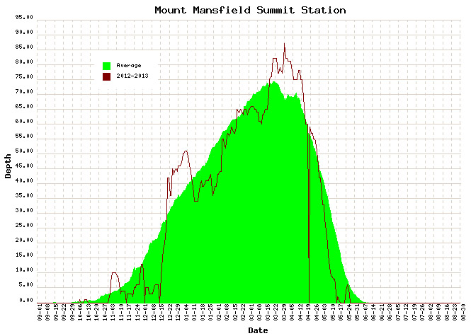
Snowpack: Aside from the spikes associated with a couple of early season storms, the mountain snowpack was below average going into mid December. That changed quickly though, with the onset of all that new snow during the second half of the month. The above average snowpack achieved during the holidays didn’t actually stay that way during January’s warmth and lack of storms. After consolidation, the snowpack generally trundled along at or below average through February’s continuation of relatively low snowfall. From mid February to mid March, the snowpack sat there essentially stagnant for an entire month; to wit, on February 21st, the snowpack was at 65”, and roughly a month later on March 18th, it was still at 65”, without any notable consolidation of more than a few inches. The late season stretch from mid March to mid April represented a nice rebound for the mountains however, with some quick gains from the big Northern New England March storm getting it above average, and the snow depth staying at least modestly above during the period.
Tree Skiing: One metric used as a rough guide for the start of off piste skiing in the Northern Green Mountains is the point at which the snow depth reaches 24” at the Mt. Mansfield stake. For those unfamiliar with how this metric was established, it’s described in some detail in the 2011-2012 ski season summary. With the incorporation of this season’s data, the mean date remains at December 12th ± 19 days, with an average depth at the stake of 25.9 ± 2.7 inches. After the very slow start in 2011-2012, in which the 24” depth wasn’t attained until January 3rd (more than a standard deviation later than the mean), this past season was notably earlier. The plot below shows the date at which 24” was obtained for each season since 1954, with 2011-2012 shown in red, and 2012-2013 shown in green:
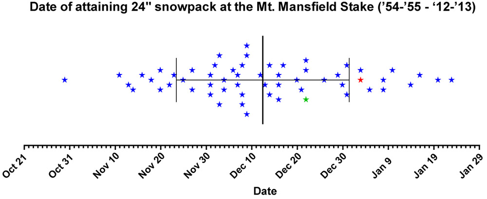
This past season, the date (December 22nd, Depth=28”, Green Star) was still later than average due in part to the slow first half of December, but unlike last season it was well within the 1 S.D. bars (thin vertical black lines). Note that the 24” mark is being used as an indicator of when the first forays into appropriate off piste/tree skiing terrain typically start in the Central and Northern Greens. In terms of empirical tree skiing observations, personal experience again lends some support to the use of 24” mark this season, as we began venturing into the trees the very next day on December 23rd at Bolton Valley. It should be noted though, that while the 24” mark was attained on December 22nd this season, the 40” mark was attained the very next day on December 23rd. The 40-inch rule (i.e. reaching a depth of 40” at the stake), is used as an indicator of when most off piste/tree skiing around here is ready to go. Although I haven’t looked into the data, this season has got to represent one of the quickest ascents from 24” to 40” – it’s interesting to note however that after rising to 42” of depth on December 23rd and 24th, the snowpack settled back to 36” for a couple of days before rebounding to 45” on the 27th.
Snow Quality: As an monitor of snow quality for the season, the chronological list of our ski outings has once again been compiled, with those days in which we were skiing powder indicated by a P, and those days in which powder skiing wasn’t available indicated by an X. The availability of powder suggests a fairly high level of snow quality, and the absence of powder generally indicates that temperatures rose above freezing at all elevations. Each listing below represents a link to the full report where images and more information from the outing can be obtained. Outings with an X may still be providing decent skiing such as wet snow, corn, etc. (or else skiing was typically avoided) but aside from the spring period, there’s going to be a price to pay in terms of snow quality associated with these episodes when temperatures eventually cool back down. The pattern of snow conditions in the Northern Green Mountains was fairly typical this past winter, with those days lacking powder skiing showing up in three distinct periods: 1) the early season with its usual temperature fluctuations, up through mid December before the weather pattern changed and the cold weather stabilized, 2) a thaw period in mid January, and 3) the period starting in mid March where spring weather began to make inroads. However, with the way the weather patterns this past spring continued to provide cool temperatures and snowfall, powder skiing generally dominated until mid April. Having analyzed the skiing in this way for the past three seasons, a surprising level of consistency is noted, with an overall average of close to four out of five days providing powder, despite notable differences in the demeanor of these recent ski seasons. The 2010-2011 season, which was above average in snowfall, provided powder on 78% of outings, the 2011-2012 season, which was well below average in many ways, revealed the same 78%, and most recently the 2012-2013 season, which was slightly below average in this area, produced a very similar 77% of outings with powder. The percentages don’t take into account differences in the number of outings each season, but with all three seasons falling into the range of 50 to 60 ski outings, differences in the sample sizes aren’t huge. The list of categorized ski outings with links to their full reports follows below:
P Stowe, VT, Sunday 04NOV2012
X Stowe, VT, Sunday 11NOV2012
X Stowe, VT, Thursday 15NOV2012
P Stowe, VT, Friday 30NOV2012
P Stowe, VT, Saturday, 01DEC2012
X Stowe, VT, Saturday, 15DEC2012
P Bolton Valley, VT, Friday 21DEC2012
P Bolton Valley, VT, Saturday 22DEC2012
P Bolton Valley, VT, Sunday 23DEC2012
P Bolton Valley, VT, Thursday 27DEC2012
P Bolton Valley, VT, Friday 28DEC2012
P Bolton Valley, VT, Saturday 29DEC2012
P Bolton Valley, VT, Saturday 29DEC2012 (Night)
P Bolton Valley, VT, Sunday 30DEC2012
P Bolton Valley, VT, Monday 31DEC2012
P Bolton Valley, VT, Tuesday 01JAN2013
P Bolton Valley, VT, Saturday 05JAN2013
P Stowe, VT, Sunday 06JAN2013
X Bolton Valley, VT, Saturday 12JAN2013
X Stowe, VT, Sunday 13JAN2013
P Bolton Valley Nordic & Backcountry, VT, Saturday 19JAN2013
P Stowe Sidecountry & Bruce Trail, VT, Monday 21JAN2013
P Bolton Valley Nordic & Backcountry, VT, Sunday 27JAN2013
P Bolton Valley, VT, Tuesday 29JAN2013
P Stowe, VT, Sunday 03FEB2013
P Bolton Valley, VT, Saturday 09FEB2013
P Stowe, VT, Sunday 10FEB2013
P Stowe, VT, Thursday 14FEB2013
P Bolton Valley & Backcountry, VT, Saturday 16FEB2013
P Bolton Valley & Backcountry, VT, Monday 18FEB2013
P Bolton Valley, VT, Thursday, 21FEB2013
P Bolton Valley, VT, Saturday 23FEB2013
P Stowe, VT, Sunday 24FEB2013
P Bolton Valley, VT, Tuesday 26FEB2013
P Bolton Valley, VT, Thursday 28FEB2013
P Bolton Valley & Backcountry, VT, Saturday 02MAR2013
P Stowe, VT, Sunday 03MAR2013
P Bolton Valley & Backcountry, VT, Saturday 09MAR2013
X Stowe, VT, Sunday 10MAR2013
P Bolton Valley, VT, Saturday 16MAR2013
P Stowe, VT, Sunday 17MAR2013
P Stowe, VT, Tuesday 19MAR2013
P Bolton Valley, VT, Thursday 21MAR2013
P Bolton Valley, VT, Thursday 21MAR2013 (Evening)
P Bolton Valley, VT, Saturday 23MAR2013
P Stowe, VT, Sunday 24MAR2013
P Bolton Valley, VT, Saturday 30MAR2013
X Stowe, VT, Sunday 31MAR2013
P Bolton Valley, VT, Tuesday 02APR2013
P Stowe & Mt. Mansfield Chin, VT, Saturday 06APR2013
X Stowe & Mt. Mansfield Chin, VT, Sunday 07APR2013
P Stowe, VT, Saturday 13APR2013
P Bolton Valley, VT, Sunday 14APR2013
X Stowe, VT, Saturday 20APR2013
X Stowe, VT, Sunday 21APR2013
X Bolton Valley, VT, Sunday 28APR2013
X Sugarbush, VT, Saturday 04MAY2013
X Stowe, VT, Sunday, 05MAY2013
X Mt. Washington, NH, Saturday 18MAY2013
P Stowe, VT, Sunday 26MAY2013
The detailed month-by-month synopsis of the season is next:
 October: It wasn’t an especially snowy October to kick off the season; we had five rounds of snow in the mountains, and the third one even dropped accumulations to the lowest mountain valleys, but none of the storms were huge dumps, and we had just a tenth of an inch of snowfall down at the house for the month. October’s first snowstorm started up on the 7th, with snowfall being reported at the top of the Mt. Mansfield Toll Road in the afternoon, and by the next morning Powderfreak sent along his picture of 4” of accumulation at the top of the Stowe Gondola. I also got a shot of Mt. Mansfield later in the day with its first accumulation of the season. It didn’t seem like quite enough snow to tempt me out to ski, but the FIS boys hit the snow and provided a thorough report of the turns. The second storm delivered some accumulation on the 11th, with a snow line up around the 3,000’ level and less than an inch of snow found up on Mt. Mansfield. The third storm was the one that finally touched the lower valleys with some minimal accumulations, but in terms of mountain accumulations, I don’t think it was anything more than junkboarding material. The 4th (on the 14th of the month) and 5th (on the 16th of the month) storms of October also appeared to be pretty minimal and generally flew under the radar in terms of discussion. So while it wasn’t a great October for natural snow skiing (with nothing like the back-to-back larger storms at the end of October during the previous season), some folks made some turns and there were several smaller rounds of snow to keep the peaks white.
 November: Snowfall for the month of November turned out to be a bit below average down at our location in the valley, but we did have five storms that delivered accumulations all the way to the valley floor. It was a decent month for snowfall in the mountains, with Stowe reporting 35” in November. That’s not outrageous by any means, but it was a noticeable increase from the previous November. It was actually the first month with below average temperatures in Burlington in 20 months, and the corresponding mountain temperatures allowed Stowe to make a tremendous amount of snow. The rounds of November snows produced some modest powder that got me out early in the month on the 4th, and mid month on the 15th, but the best skiing was right at the month’s end. A storm overnight on the 29th dropped a foot of fresh fluff on the Northern Greens and then cleared out for some great turns by dawn patrol time. That new snow on top of previous rounds of accumulation delivered some fantastic bottomless powder skiing that held up even on steep terrain like Stowe’s National trail.
 December: The great powder conditions from the end of November storm carried right over into the beginning of December, with some excellent skiing on the 1st of the month. That was really the highlight of the first half of December however, as snow was hard to come by through the 16th; we had just 2.2” of snow at the house during that period. It was as if a switch was flipped for the second half of the month though, with winter roaring back in to deliver almost 50” of snow for us in the valley. Some of the more significant storms during that stretch were on the 21st, with up to 20” of accumulation, the 26th, with over two feet, and the 29th, with another foot plus thrown in for good measure, so naturally the skiing during the holiday period was blissfully powdery. Even on days between the more substantial storms, a new half foot of snow could pop up. It was just day after day after day of powder, with even a little night added to the mix. The only detractor from that stretch was that the snowpack wasn’t initially up to the depths to allow people to enjoy that powder on all terrain. The natural base depths did make some quick and significant gains during the period though, with the 24” threshold depth at the Mt. Mansfield Stake being attained on the 22nd, and the 40” mark reached on the following day as described above in the section on tree skiing. Our first notable forays into the off piste were on the 23rd at Bolton Valley, which wasn’t surprising with almost all of Stowe’s terrain getting opened by that point. The off piste was quickly going… off, and things just went up from there. That storm on the 26th had a somewhat uncommon east wind, which filled in the Bolton Valley headwall areas for some fantastic coverage. Despite the relative scarcity of snowfall in the first half of the month, by the end of December, Stowe was at a respectable 102” of snow on the season.
 January: December’s snows and excellent ski conditions continued into the beginning of January, with four modest storms hitting the Northern Greens during the first week. In the higher elevations, the largest of those storms came in on January 4th and affected the northernmost resorts hardest, with a foot at Jay Peak. Even with somewhat lower totals at resorts to the south, the skiing remained quite good because of all the powder that had been building up over the previous three weeks – we found over a foot of powder lurking in the trees at Bolton Valley on the 5th. More snow came in that night to produce a nice day at Stowe on the 6th, and after the final snowfall event in the series, the snowpack at the Mt. Mansfield Stake stood at 51 inches on the 7th. The stormy stretch ended after that, and warm temperatures brought spring-like ski conditions until mid month. Fortunately, the base depths that had built up over the previous three weeks meant that there was a lot of good, soft skiing. Winter was back by mid month, with small systems that brought a return to some powder conditions. The fourth week of January featured arctic cold, which unfortunately meant little snowfall, but at least the temperatures preserved the powder. Finally at the end of the month we got a modest half foot storm to bring back some fresh powder, but January as a whole was quite low on snowfall – down at the house it was by far the least snowy January in my weather records.
 February: The month of February rolled in with a tempered return to the type of dry, arctic pattern that we’d encountered in that fourth week of January, but fortunately there was at least a bit more moisture and temperatures weren’t quite as cold. There wasn’t much new snow for the first weekend of the month, but at least the skiing was decent. Of the three storms that came in that following midweek, the second one brought from a half foot to nearly a foot of powder at some of the Northern Vermont resorts, so the skiing improved. Just in time for the next weekend, the “Nemo” storm hit the Northeast, and while it was largely a miss for Northern Vermont relative to areas to the south that got up to 40” of snow, the mountains still picked up more than a foot of powder to provide some excellent turns. Nemo was followed by a storm named “Orko”, which came in at the beginning of the following week with 1 to 1.5 feet for some of the local resorts. Beyond that storm, mid February was fairly dry, but powder conditions persisted, and on the 19th a more sizeable storm hit the area with snow totals of 1 to 2 feet plus for the Northern Vermont resorts. The month finished off with a few more storms, with a half foot storm and a 1 to 1.5-foot storm being the more notable ones. Although the month as a whole was actually rather lean on snowfall (only an inch from being the least snowy February in my records at the house), as it typical, the consistent availability of powder rolled right on into March as seen in the categorized list of ski outings above.
 March: The first half of March wasn’t especially snowy, with just one notable storm in the ½ to 1-foot range for the mountains; the big storm that affected southern parts of New England with up to 30 inches of snow in the March 5th-8th period was literally a non-event in Northern New England. Of course even with some warmer temperatures in the second week, decent powder remained in the higher elevations, and soft snow made for fun turns on piste. Around mid month though, the skiing started to get even better as the snowfall picked back up with back to back modest storms and 72-hour snow totals topping out around 16 inches on the 16th. Thanks to the ability of the Central and Northern Greens to reel in snow, conditions moved well beyond the dust on crust that many areas to the south were likely encountering. That was the start of an excellent stretch of winter that was second only to the snowy December period, with our largest valley storm of the season arriving on March 19th and delivering 7-day snow totals of 2 to 4 feet in the mountains. At Stowe they were calling it “Powder Week” and the deep turns just kept on coming. The increase in mountain snowpack during the period was notable in that it finally moved solidly above average and stayed there Simply put, even lift-served powder skiing was endemic on piste during that second half of March until a brief warm-up during the last couple of days of the month.
 April: Despite the somewhat slow increases in the snowpack during the heart of the winter, the gains made during the latter half of March meant that the snowpack was at least modestly above average heading into April, and it quickly reached a peak of 87 inches at the Mt. Mansfield Stake when the first storm of the month dropped a foot of snow at Stowe on April 2nd. I was up at Bolton Valley that day for a ski tour, and I got to witness some impressive snowfall rates as the storm crashed into the higher elevations. The alpine terrain above tree line on Mt. Mansfield was in good shape, consistently providing excellent outings during that first part of the month. Cool temperatures with additional snow meant that the snowpack stayed at an above average level right through the month, and another storm on the 12th saw Ty and I enjoying close to a foot of dense powder out in the Bypass Chutes at Stowe on the 13th. The skiing gradually transitioned to full on spring conditions after that weekend as the active pattern waned, and an impressively long stretch of clear weather moved in and stuck around well into May.
 May: For most of May, there wasn’t much to talk about in terms of new powder, especially with the extended period of incredibly clear weather that carried over from the end of April and lasted a fortnight, finally ending on the 10th of the month. There was some mighty fine spring skiing right through that period with all the sun and warm weather, even if it did cause the snowpack to decrease a bit faster than it otherwise might have. The tranquil period of warm weather allowed the Mt. Washington Auto Road to open on the 10th of the month as well (definitely on the early side), but since unsettled weather had just returned at that point, we didn’t get to make our spring pilgrimage to the snowfields until the 18th. To really cap the month off well, Northern New England and the Adirondacks were rewarded with a Nor’easter over Memorial Day Weekend, which delivered roughly 3 feet of powder to Whiteface and nearly 2 feet to Mt. Mansfield. Excellent powder turns were made while the valleys were almost fully leafed out for the spring. We didn’t actually head out for any June turns beyond that, but the skiing over Memorial Day Weekend had been so good that it hardly mattered – it was just a few short months until the snows of fall would be returning.
So what about the overall feel for the quality of the ski season in Northern Vermont? Well, much like the snowfall numbers suggest, it feels like it came in a bit below average, even if not horribly so. The mountain snowpack (as gauged by what was seen at the stake on Mt. Mansfield) had its ups and downs, and on balance it probably gets rated in a similar manner to what the slightly subpar snowfall would suggest. Being frequent Bolton Valley skiers and living down below the mountain in the Winooski Valley, our perspective might be skewed a bit downward with the resort receiving just 78.5% of their average snowfall. Having the north miss out somewhat on a couple of big regional storms, while watching a horrid valley snowpack (see the 2012-2013 Winter Weather Summary for details) that kept ski routes to the lower valley bottoms essentially off the table, certainly didn’t win the season any extra points. It seems that 2012-2013 ultimately sits in the lower half of ski seasons and won’t be remembered as anything epic, but it also appeared to hold onto a decent level of powder availability (77%) based on our experiences, and that means there was still a pretty decent amount of good skiing. The fact that even the poor 2011-2012 Ski Season was able to hold onto a powder percentage in that range is also reassuring in that regard, suggesting that there is indeed a certainly level of reliability that can be expected in these seasons where snowfall/snowpack is below average.


")


Third October snowfall finally reaches to the valleys in Vermont

White tendrils of snow began to appear along the western slopes of the Green Mountains late this morning as the cold air moved into the area, and people started seeing snow all the way down into the valleys. Although the snow from Monday and Thursday only affected the mountains, we picked up our first accumulating snow at the house today as a heavy graupel storm came through in the afternoon. Tonight is supposed to be the coldest of the season so far, and there’s still the chance for a bit more snow before the weather warms up going into next week. For more information about today’s snowfall, be sure to check out my post in the American Weather Forum. For the full details on this storm, head to the detailed report at the winter weather section of our website.
Next round of October snow hits the peaks in Northern Vermont

As the sun rose Monday morning, it revealed the first accumulating snow in Vermont this season, but the next event was close on its heels, with another round of snow laid down on the peaks of the Greens today. It was raining and 41 degrees F at the house this morning, but that translated into snow 3,000’ to 4,000’ up. The snow line appeared to be a bit higher with this event, up around 3,000’, and less than an inch of new snow was reported at ~3,700’ on Mt. Mansfield. Although this snowfall wasn’t as substantial as the last one, it was definitely enough to paint the peaks white. The cold season is definitely edging closer though, as the higher elevations of Mt. Mansfield stayed below freezing all day for the first time this season, and even more snow could be on the way tonight.