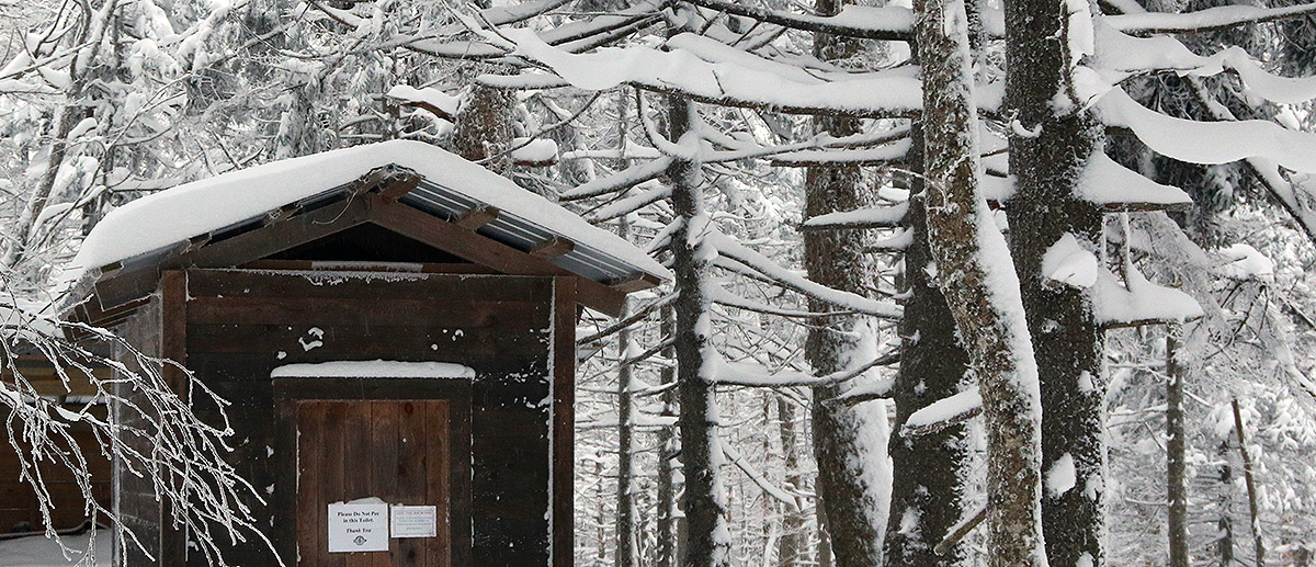
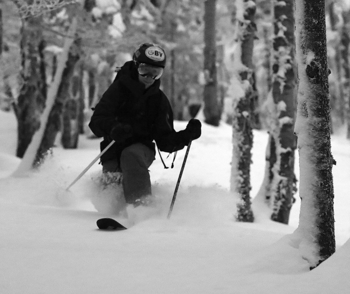
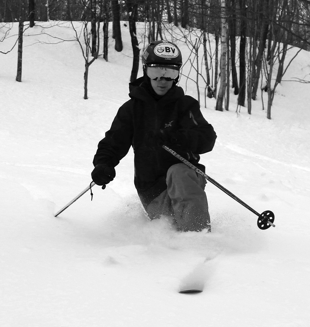
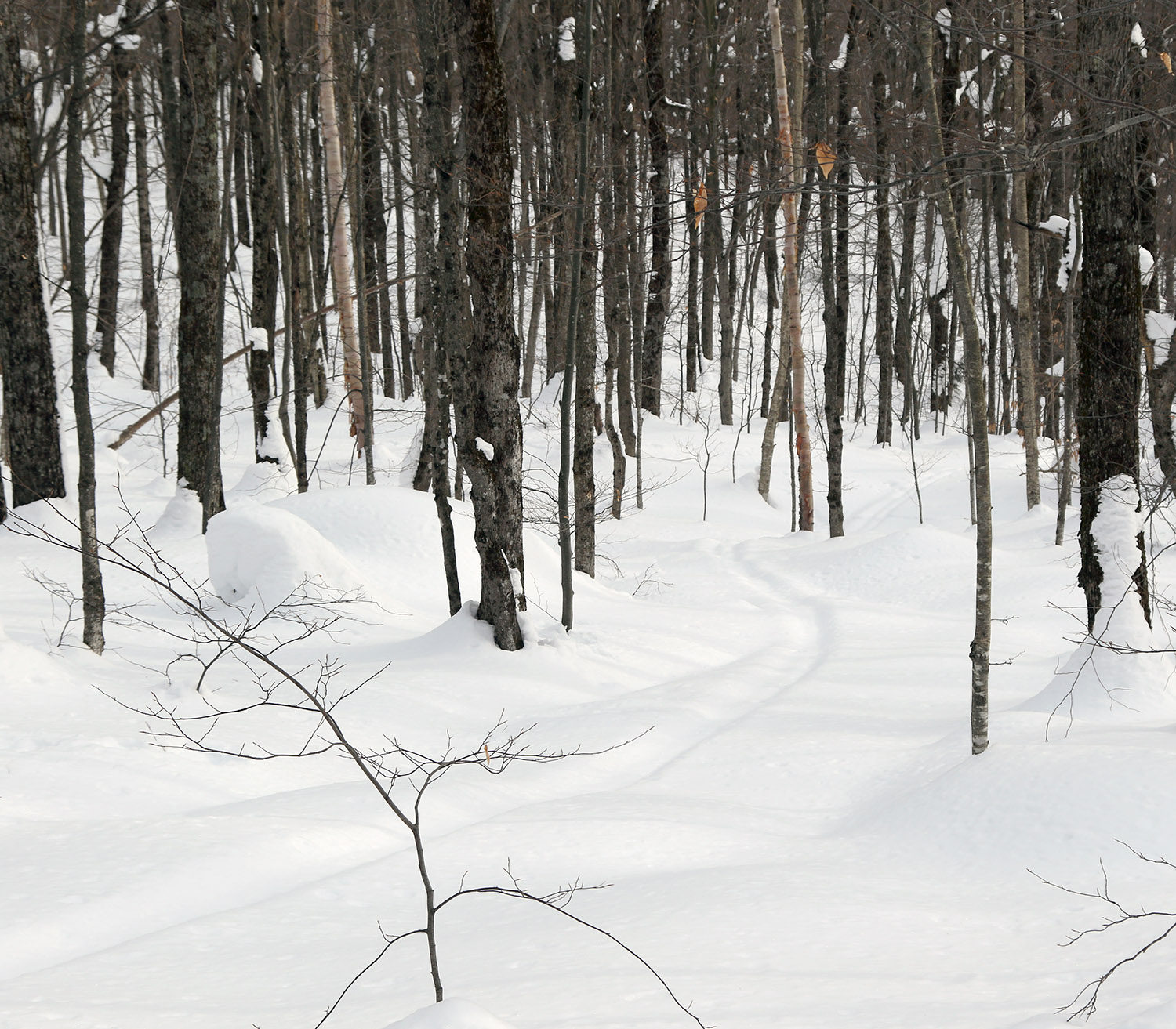
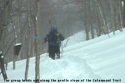
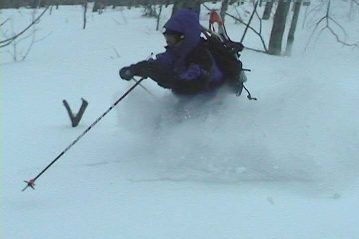
Ty out in some of Bolton’s Backcountry Network glades today enjoying the powder from Winter Storm Diaz and the additional rounds since then
It’s continued to snow over the past couple of days, and we’ve had another 3 to 4 inches of snow down here at the house that’s come in with an average density of around 4% H2O. The back end of Winter Storm Diaz had already topped off the snowpack with some dry upslope, so we expected that these additional rounds of snow should just represent more quality stuff that’s topping off the upper layers of powder that are already present. Ty and I headed out for a tour this afternoon that took us a bit above Bryant Cabin, and we skied a good variety of different glades that really solidified just how good the skiing was. The shallowest slopes are still a bit slow with the depth of the powder, but very nice if you want a gentler pace that lets you work in and out among tighter trees. As we’d already experienced back on Saturday at Wilderness though, the steep and moderate slopes are skiing great.
It’s amazing how one storm simply brought the backcountry conditions from very early season stuff that I hadn’t even contemplated skiing, to something that skis like a top notch midwinter snowpack. And it’s not as if this last storm cycle was a 3 to 4 foot monster. The snowpack we were skiing today is only in the range of about 20 inches, but apparently it’s just laid down so well that it does the job. I’m sure there are steep slopes out there with lots of big obstacles that are nowhere near ready, but the typical glades we skied on the Bolton Valley Backcountry Network today were in great shape.
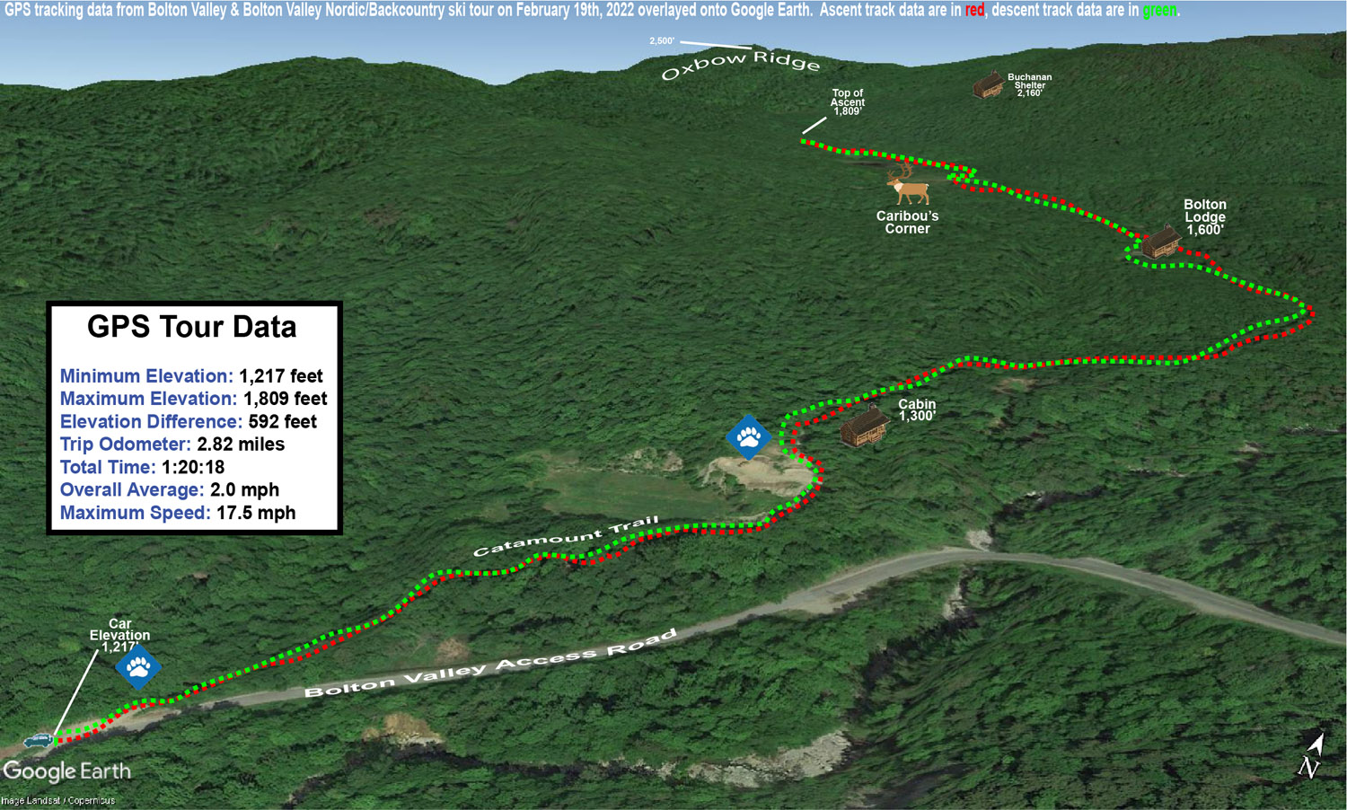
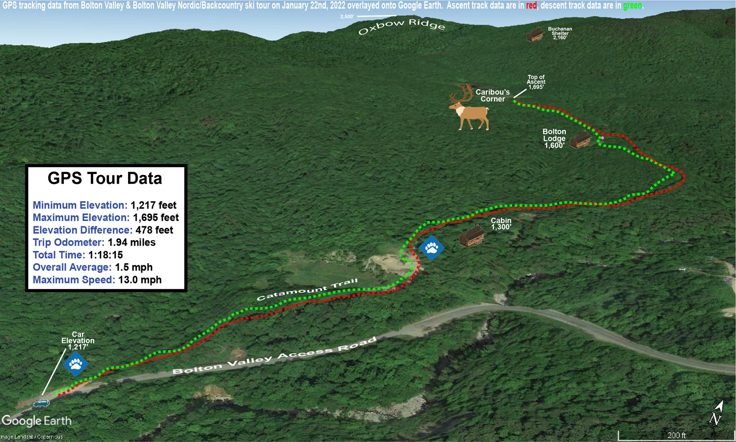
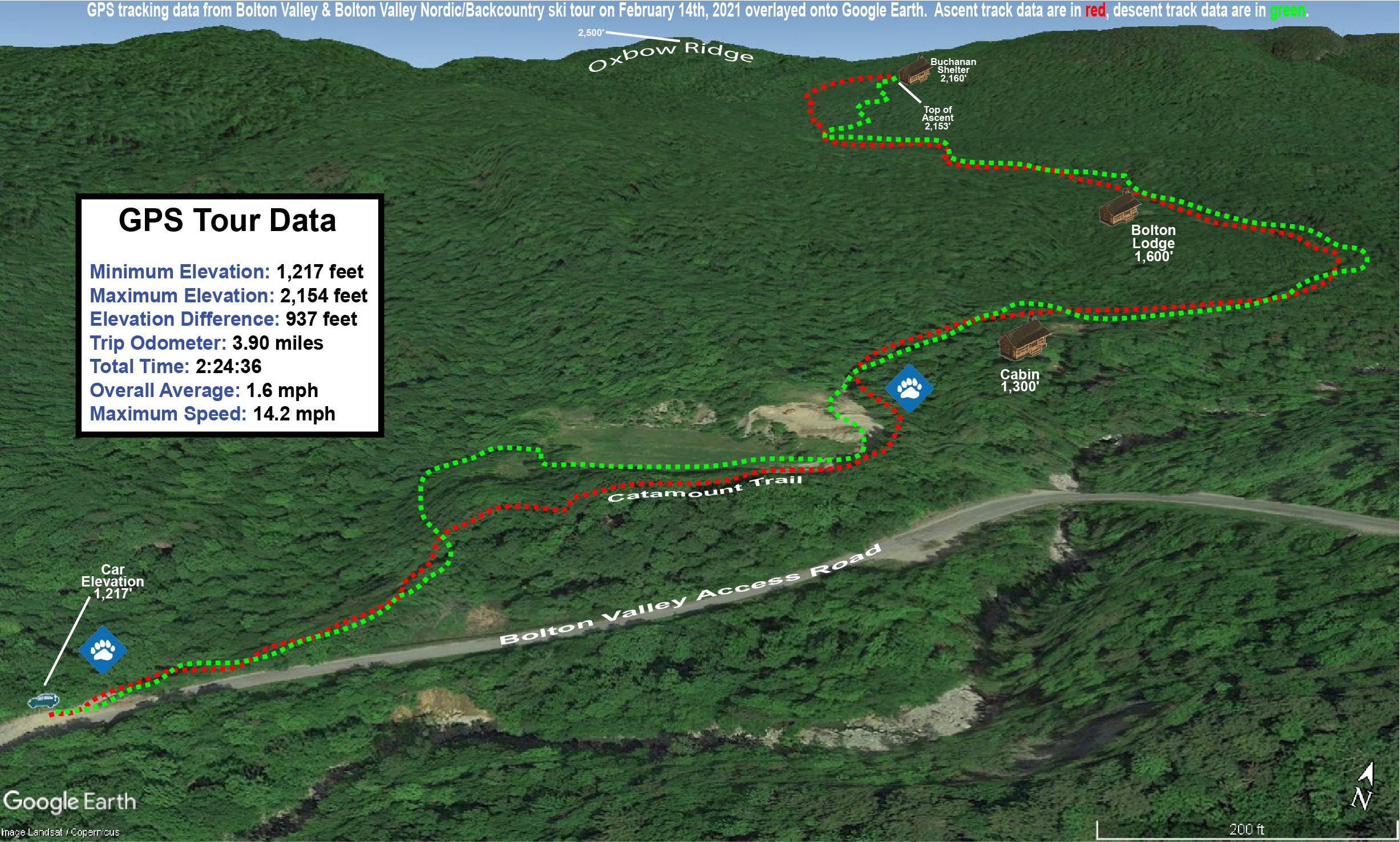
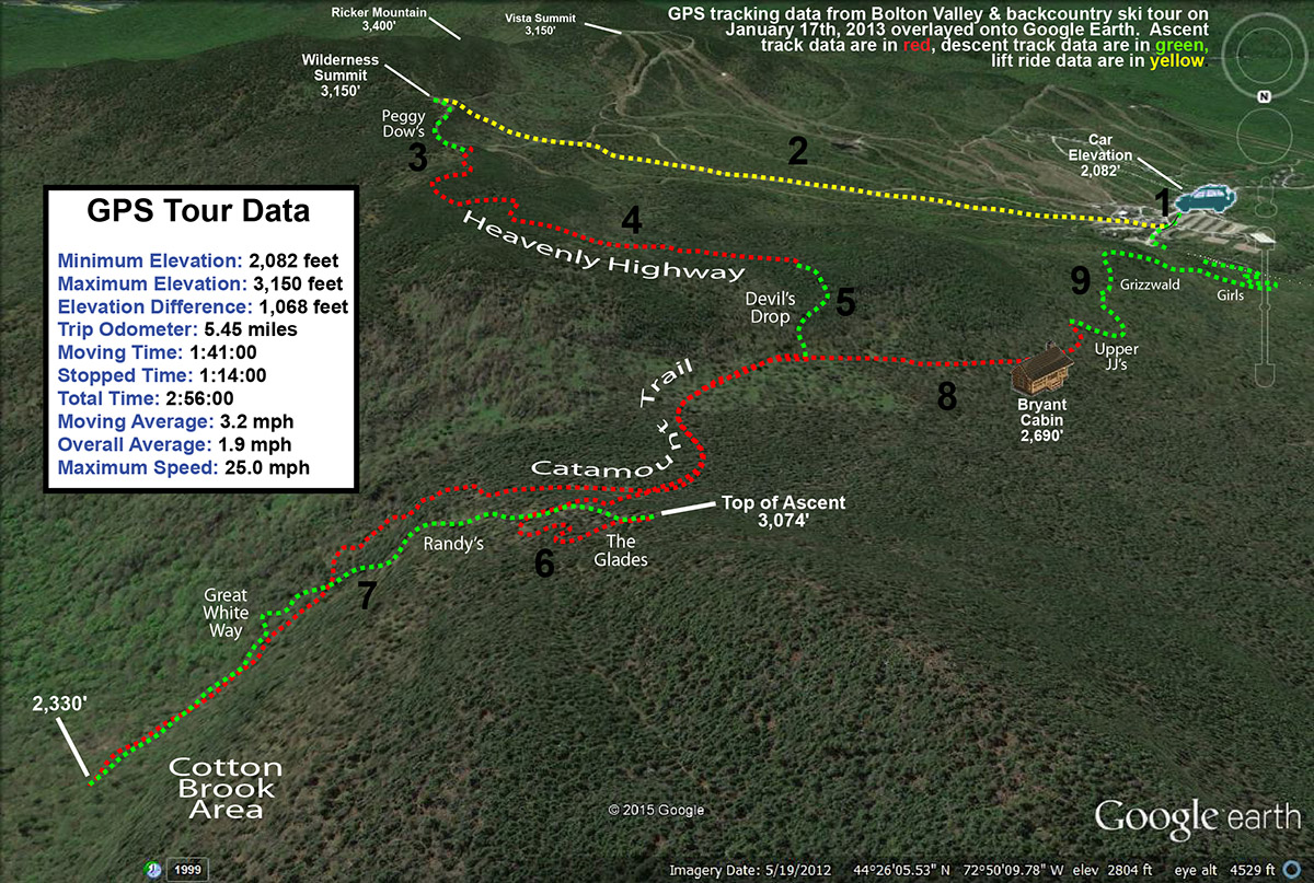
A Google Earth map with GPS tracking data from today’s ski tour out on the Bolton Valley Nordic and Backcountry Network.
We had comfortable temperatures in the 20s F, and found about 3 inches of new snow starting at the 1,200’ elevation. My initial plan was to head up to at least the Caribou Corner intersection, and then see how we felt at that point in terms of snow conditions and timing. Even at a casual, conversational pace, Ty and I were quickly at Caribou Corner, and I figured we could go on past to see what the snow looked like beyond the beaver ponds. Surface snow depths were generally in the 3-4” range, but we did find a few spots of up to 7” by the beaver ponds. We finally stopped our ascent around the Moose-ski trail on a local rise that set us up with an initial descent of relatively low angle pitches.
The Google Earth map with GPS tracking data for today’s ski tour on the Bolton Valley Nordic & Backcountry Network
Even on low-angle terrain, we were still touching down to the base with any substantial edging, and only occasionally would be find just the right combination of snow depth and pitch where we could get in some bottomless turns. Those spots where you could make a gentle turn without much angulation were the ones that delivered.
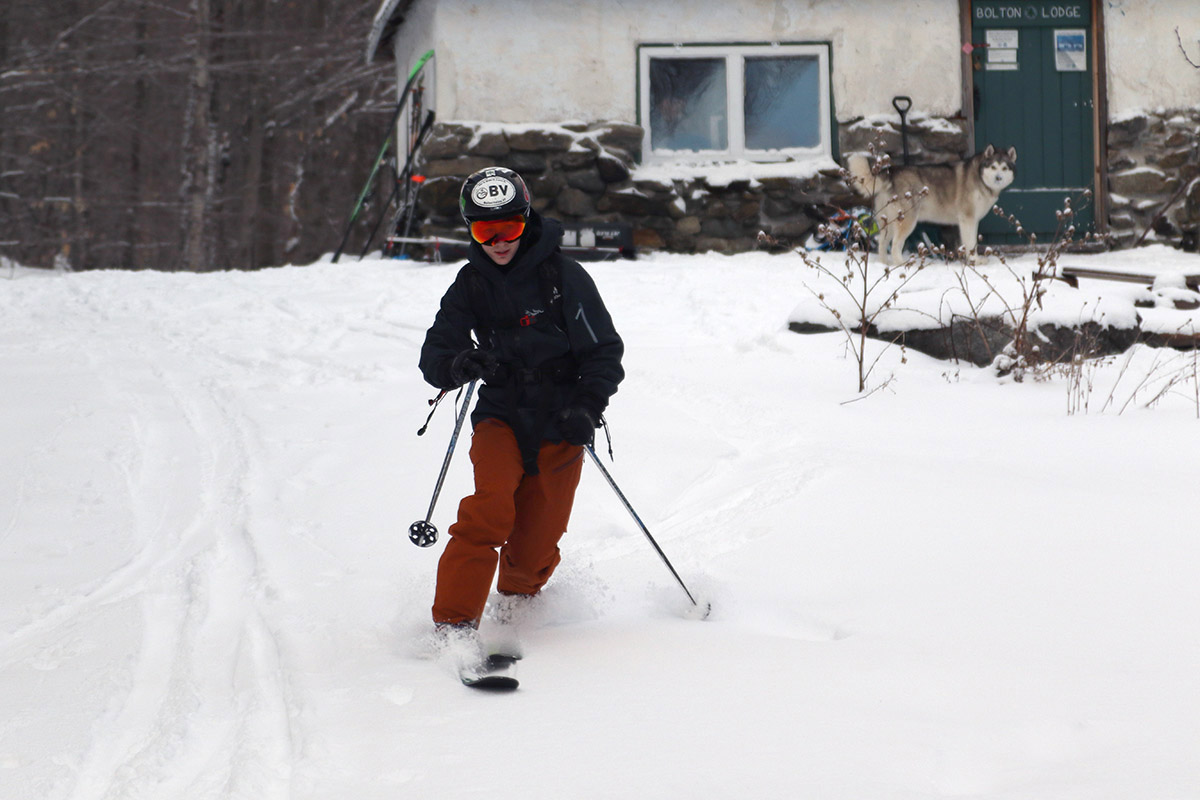
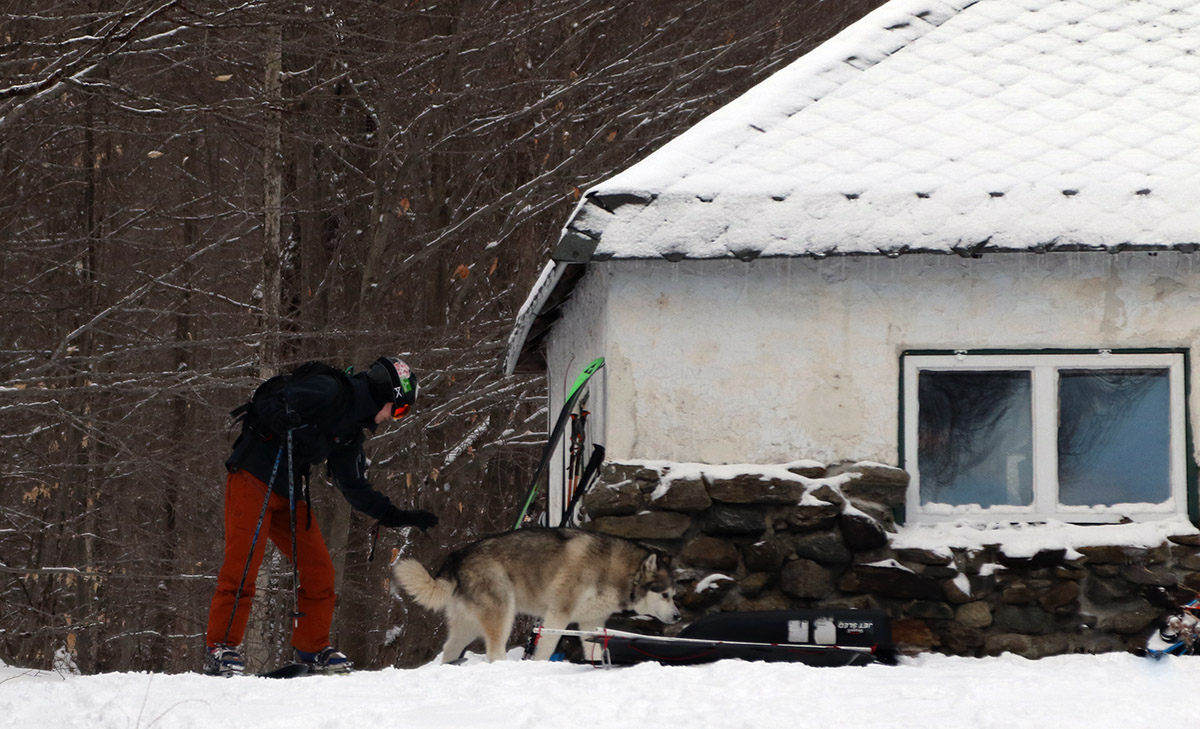
Ty and his furry friend out by the Bolton Lodge on today’s ski tour
A fun aspect of the day was interacting with the Husky that seems to live at that house/cabin that’s about 10 minutes up the hill along the Catamount Trail. It’s a really well-behaved dog that seems to interact nicely with most people who are out on that area of the network. On our ascent, we parted company with the Husky a few minutes after passing the house, when it joined a group of children who were sledding in a spot just below the Catamount Trail. On our descent, the Husky was right at the Bolton Lodge, and joined us for the rest of the descent back to the cabin, where we met the owner. What a great back yard that Husky has! With the Catamount Trail and Bolton’s Nordic and Backcountry Network right there, I bet there’s hardly even a shortage of people to play with.
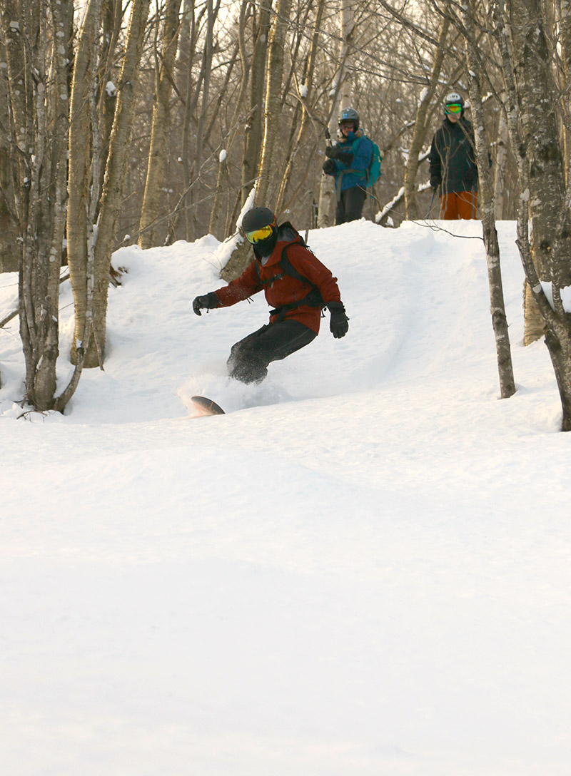
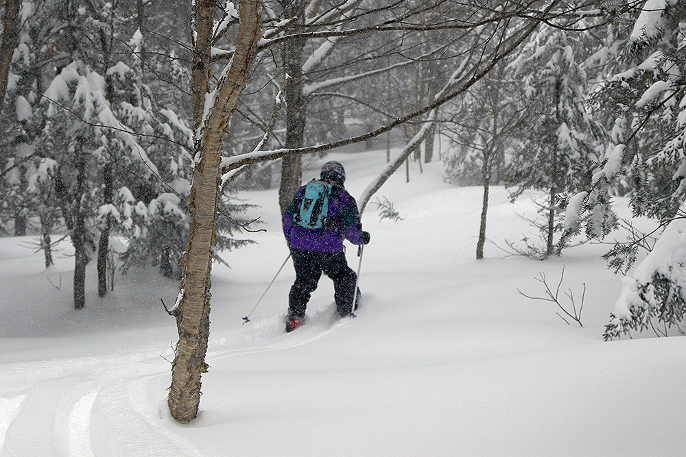
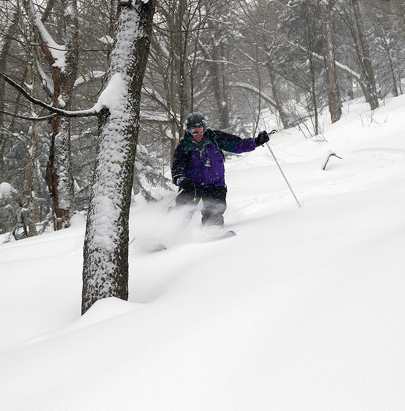
Dylan surfing some powder near the Bolton Lodge during today’s backcountry tour
Today is Ty’s birthday, and the whole family was around with time to do something together. Ty’s broken collarbone has healed to the point where he doesn’t have to wear a sling, and light activities that don’t put stress on it are fine. On Sunday, Ty and E and I went for a snowshoe tour on the Bolton Valley Nordic & Backcountry Network, and after some discussion today, we decided that some ski touring on mellow terrain would be fine.
D is still trying to find some new Telemark boots that fit better, so he just hiked in with his snowboard – most of the approach is either road, or packed trails, so it didn’t turn out to be a problem. Ty did give D a ride on the backs of his skis at times, which was sort of neat. Ty said it was a lot of work, but D could help out the process a lot by using his poles.
A Google Earth map with GPS tracking data for today’s tour on the Bolton Valley Nordic & Backcountry Network
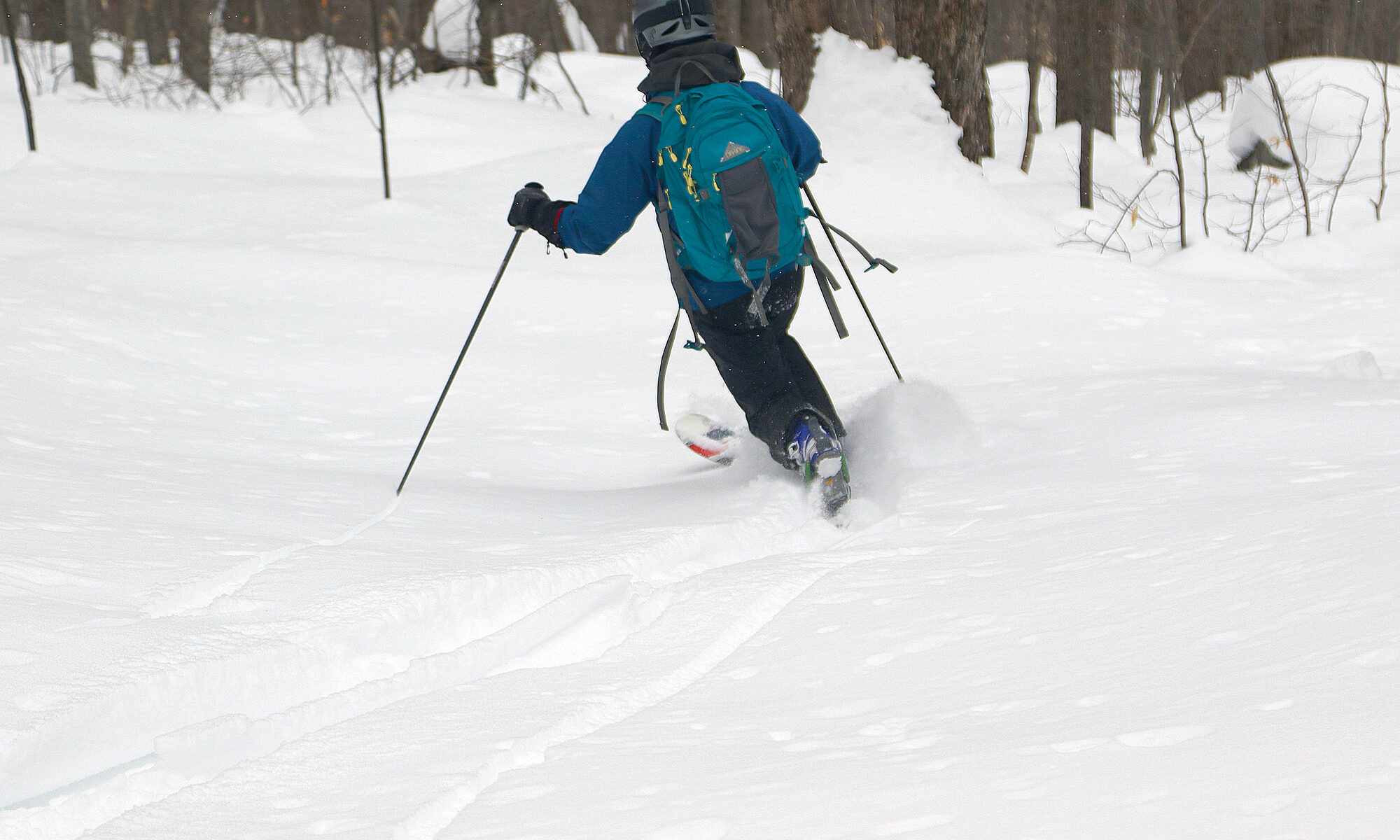
I’d found total snowpack depths of ~18” at the 1,500’ elevation when I toured in the Timberline area on Tuesday, and even starting down at an elevation of 1,200’ today there were no major issues with the base. The powder out there in the backcountry is still in excellent shape – depth checks I did today in the 1,200’ – 1,700’ elevation range revealed powder depths of 12-13”. That’s actually a bit deep for some of the lower angle spots on today’s tour, but the descent was still nice. We also hit some of those slightly steeper shots around the Bolton Lodge, and those pitches offered up some great powder turns.
“…the powder I found was so exquisitely good, that I had to get E out there for some turns as well.”
Thanks to my explorations on trails like Moose-Ski and Grand View, I knew the most efficient and direct approach route to the Buchanan Shelter was to simply take the Catamount Trail to Beaver Pond. I’d taken this as my final route out on yesterday’s tour, and it really worked well as a rather direct and efficient gravity traverse back to the car. Indeed, it was quite the efficient route for the approach today, and it’s such a gradual incline that before you know it, you’ve gained several hundred feet of elevation.
During yesterday’s tour, I was pressed for time, so on my descent from the Buchanan Shelter, I had to stick near Upper Beaver Pond. Today we had plenty of time, so we were able to explore more to the east to find the best lines. There’s plenty of open forest for turns, and we were able to pick some fantastic lines that brought us right back down on Deer Run near the junction with Beaver Pond. We also had plenty of time to enjoy additional turns in some of the low-angle powder on the return to the car.
GPS Tracking for today’s tour on the Bolton Valley Nordic & Backcountry Network overlaid onto Google Earth
The powder was just as excellent today as it was yesterday, so it was a great ski outing. And, the fact that it just ended up being the two of us was sort of neat in the context of Valentine’s Day.
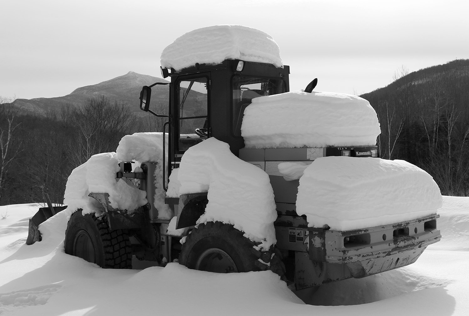
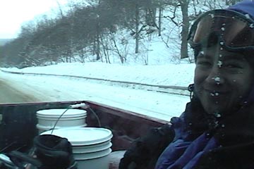
Views along today’s ski tour – a bucket loader covered with snow shows the various layers in the snowpack that have accumulated from recent storms.
Today was expected to be fairly chilly, with temperatures topping out in the teens F, and without any fresh snow in a couple of days, backcountry touring seemed to be the call.
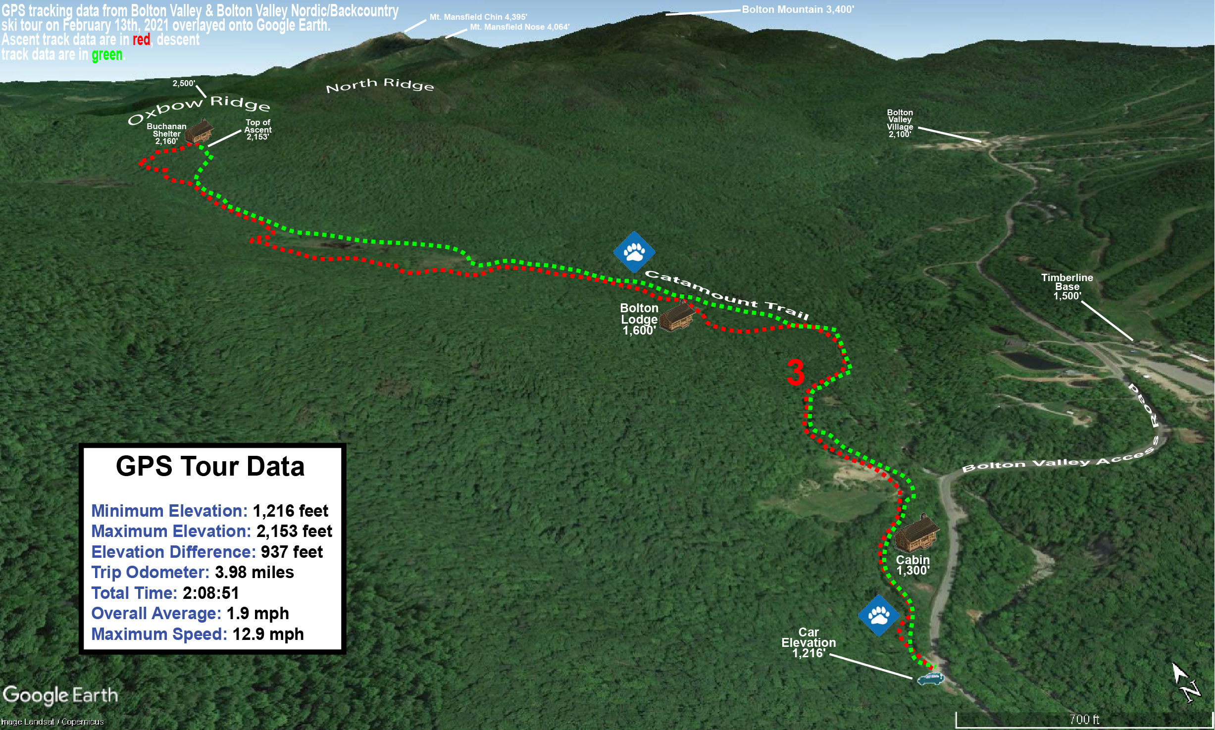
I was looking for something new to explore, so I planned a tour in the southwest corner of Bolton’s Nordic & Backcountry Network. I’ve only just scratched the surface of this part of the network in previous visits, so I was eager to see what options there were for descents with good tree skiing. My anticipated route was to start from the Catamount Trail parking lot on the Bolton Valley Access Road at ~1,200’, head up through the expansive beaver pond meadows in the Mt. Mansfield State Forest, and top out around the Buchanan Shelter at 2,150’ below the Long Trail.
On my ascent I was on the lookout for potential descent options, exploring trails on the network such as Moose-ski. The terrain was nice, but generally rolling, so while there were some nice short descents, it would be challenging to incorporate these into an efficient tour once my climbing skins were removed. The views from that area across the beaver ponds did provide some great views back toward the alpine trails and the Village area.
Beginning my descent through the powder today near the Buchanan Shelter.
The best powder skiing terrain on the tour was definitely on the slopes below the Buchanan Shelter, with some nice areas of open forest. The only sign of skiing in that area was an old ski track from someone that must have been there at least a couple of storms ago. I suspect traffic is generally light in this area because it requires an approach that’s close to two miles, vs. much quicker access in many other spots on the network. There’s a vast area of terrain for good descents off the ridge where Buchanan Shelter is located, enclosed by the Long Trail, Goat Path, Lower Maple Loop, Deer Run, and Beaver Pond.
Even without new snow in a couple of days, the snow preservation has been so good, that the quality of the powder is simply spectacular. The snowpack I found was generally in the two- to three-foot range, but there’s such good density in the bottom layers that anything of concern is well covered.
A Google Earth map with GPS tracking data of today’s ski tour on the Bolton Valley Nordic & Backcountry Network
I was unsure how smooth the traverse out was going to be via the direct route back to the Catamount Trail, since I’d come in by an alternate route using Grand View and Moose-Ski. Indeed, the direct route out on Beaver Pond is quite quick – it’s essentially a gravity traverse with a few spots that require glide and kick or double polling, but there are even spots below Caribou’s Corner where it’s steep enough that you can get additional turns in the powder outside the skin track.
Stephen enjoying some of the great snow out there in the Bolton Valley backcountry today
Today was a big ski day for Stephen. He’s been working hard, for what seems like years, to put together an appropriate alpine touring setup for backcountry skiing at a reasonable price. Over the past few months, the final pieces have finally been coming together. Despite his son Johannes “stealing” critical pieces of what appeared to be his final setup, the gear swapping, shop visits, adjustments, readjustments, and everything else that tried to get in the way, was eventually settled. All that remained was finding a day in his busy schedule to actually use his fancy gear. Today was that day, and the Bolton Valley Backcountry Network was the place.
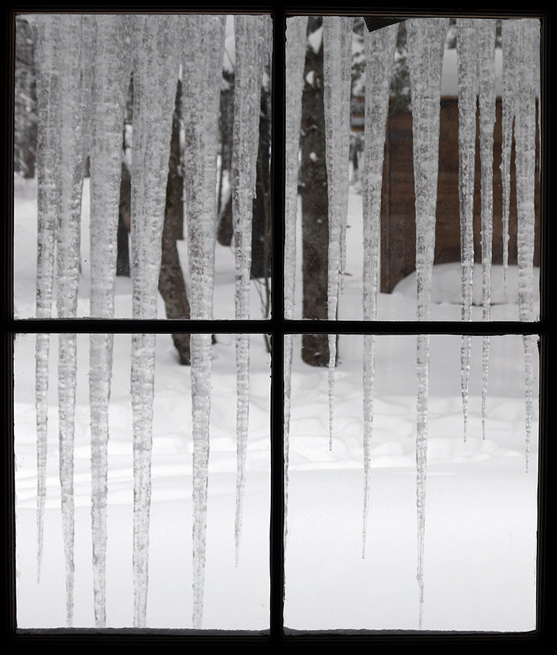
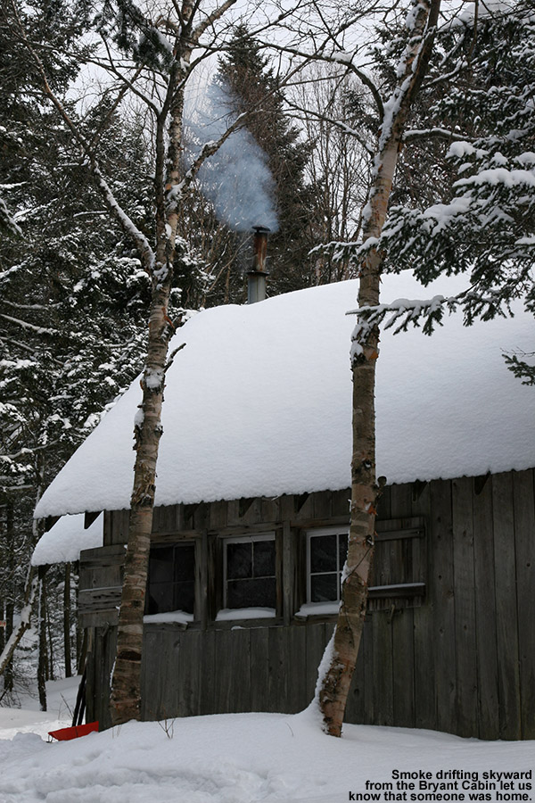
We got a fairly early start to give us plenty of time for a tour of whatever length we chose, I figured I’d give Stephen a good introduction to some of my favorite parts of the network that he’d never visited. We’d be able to adapt the length of the tour as needed to fit energy levels and any equipment issues. Snowfall from Winter Storm Skylar was just getting started as we began our tour from the sports center, and it intensified on our ascent of the Bryant Trail. We saw only one other person on our ascent, and with the Bryant Cabin vacant, we were able to check out the upgrades that had been done as we took a quick break. Clearly the cabin has seen some recent use, because the icicles draped down from the roof were some of the largest I’ve ever seen.
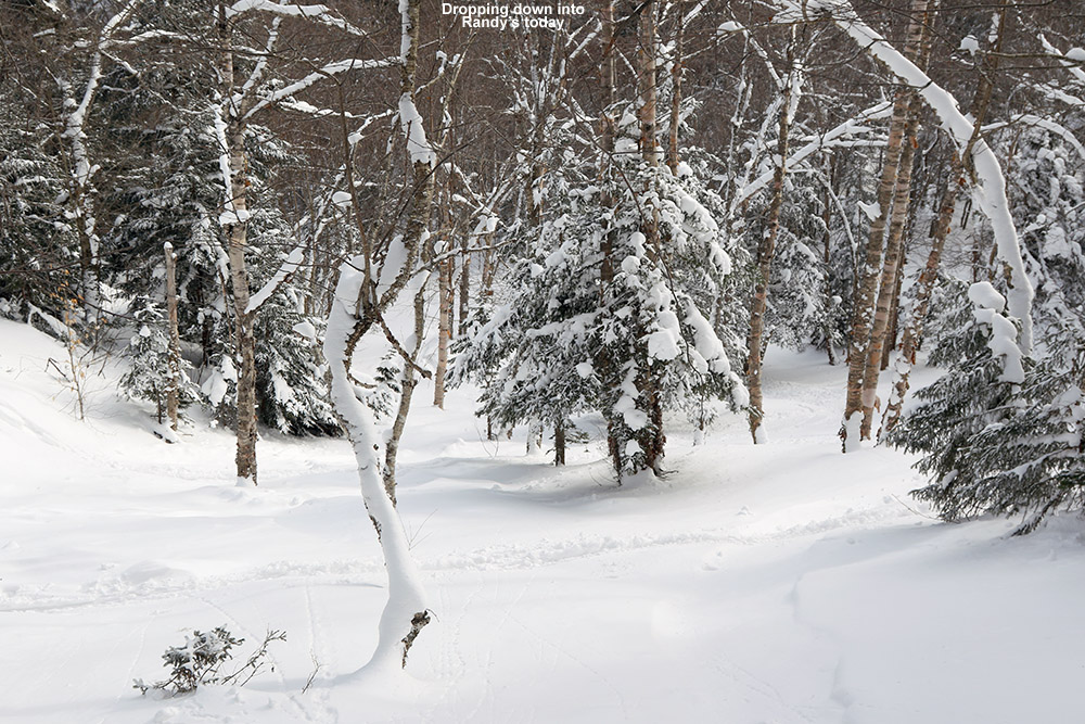
The next leg of our journey took us up to “The Glades” above the Catamount Trail, where we stopped our ascent around 3,100’. Although the storm occasionally brought us some slightly larger flakes, they were for the most part small, with diameters in the 1 to 2 mm range. This meant that the new snow was fairly dense, and it was covering everything underneath it quite well. We continued down into the Cotton Brook Glades on Randy’s and Great White Way, and found some impressive untracked lines. Stephen had a few good explosions in the powder, but he seemed thankful for most of them as they helped cool him down after the long ascent. Those steep, tight sections on Randy’s were certainly the most challenging, but Stephen had some of his best turns down in the mellower pitches of Great White Way. I find that those lower angle areas are some of my favorites as well unless you’ve just picked up two feet of fluff and really need the steeper pitch.
The ascent up from the back side was quite a labor at times. It’s always tough skinning out in a few spots of that Cotton Brook ascent. It’s just steep and narrow near the bottom of Randy’s, and there’s no way around it, so you have to try your best to set in switchbacks. We were fortunate to have use of the old skin track that’s in place, but we were slipping on the steepest pitches. Stephen was definitely feeling it as he’d take one step forward and what felt like 10 steps back, especially as he was getting used his very first day on his skins, but we made it through that struggle and the pitch of the ascent improved dramatically. When we cut Stephen’s skins for his skis at full width, I was telling him how I considered that approach a “no brainer” vs. going with anything narrower, and after today’s ascent up from the Cotton Brook area I know he agrees 100%.
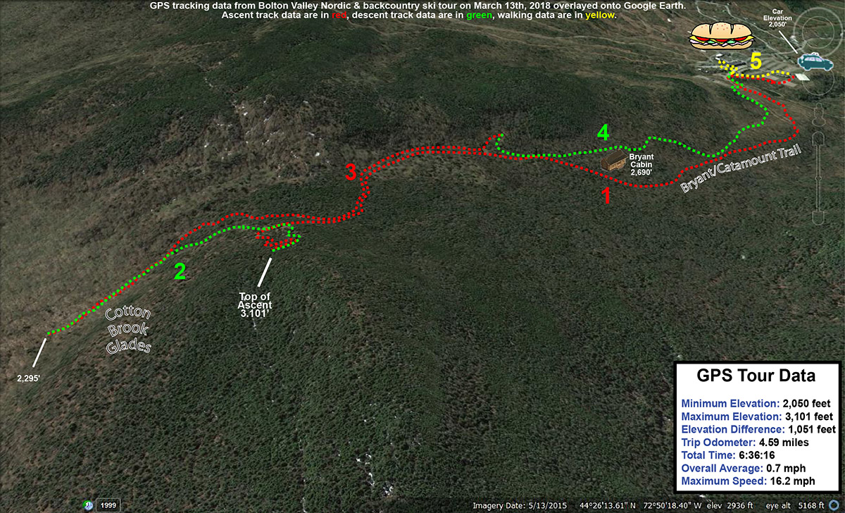
GPS tracking data for today’s tour into the Bolton Valley backcountry
We finished off the tour with a line below Heavenly Highway down to Bryant Cabin, then on to Gardiner’s Lane and JJ’s, which delivered one of the best runs I’ve had there. We’d certainly accumulated a few fresh inches of snow from the storm by that point, which helped make the skiing extra soft. The Telemark Practice Slope was also aided by all the new snow, and made a nice end to the tour. Actually, the tour wasn’t quite over at that point because we added on one of the most important parts: sandwiches at the Bolton Valley Deli & Grocery. We even got to chat with Ralph Deslauriers while we were there, and naturally one of the topics of conversation was the very snowy week we’ve got to look forward to. It sounds like Winter Storm Skylar is going to move up into Northern Maine and wrap some of that abundant Atlantic moisture into the Northern Greens, just like the way things happened last week after Winter Storm Quinn!
Heading down into the Cotton Brook area on today’s backcountry ski tour near Bolton Valley.
Best… Bolton… backcountry… tour… ever. That’s really the only way to start this trip report, because even after years of exploring the backcountry around Bolton Valley, that’s what today’s tour was for me. I can’t say that this tour was tops in every category; the powder was fantastic, but there have been numerous days that top it, and E and the boys weren’t with me, so it was a solo outing. What made the tour so great though was the combination of great powder on all aspects, the good distances covered to provide a nice workout, but most importantly, the breadth of the backcountry network used and the substantial number and variety of glades visited. The tour spanned all the way from the alpine trails of Wilderness to the Cotton Brook area, and featured nine different glades. What also made the tour so outstanding was that I could use my knowledge of the area to connect all those glades very efficiently; in terms of powder turns that meant getting the most bang for my buck.
“…we just keep getting “small” snowfalls to freshen the slopes and top off the powder, but of course around here that’s meant 1 to 2 feet in the past week.”
It’s a holiday weekend, which typically means lots of visitors to the ski resorts, and the forecast today called for fairly chilly temperatures in the single digits for the mountains. That’s a combination that just calls out for some backcountry touring, and that’s the plan that gradually evolved this past week as I watched the forecast. Although we haven’t had any huge storms in the past week or two, the snow out there in the Northern Greens is simply fantastic – we just keep getting “small” snowfalls to freshen the slopes and top off the powder, but of course around here that’s meant 1 to 2 feet in the past week. And, the January weather just keeps all that powder pristine.
Ty was out at a dance until late last night, and friends came back to our house and stayed overnight to play with him and Dylan. I wasn’t about to pull them away from that this morning, and in fact, I wasn’t really planning to ask anyone if they wanted to ski with only single digits in the mountain forecast. I knew it was going to be one of those days where it could be uncomfortably cold if you didn’t keep moving, so going out by myself meant that I could keep the tour at whatever pace I chose. Knowing that I was going out solo also let me devise a more ambitious tour than if I was heading out with the whole family. After considered the many options, I decided that a lift-assisted tour out toward the Cotton Brook area would be a good option. There are glades farther to the north there that I’ve yet to explore, and at a decent pace, it looked like I’d be able to put together a solid tour out to that area and back in the three to four hour window of time I had.
The Wilderness Chair was scheduled to start running at 10:00 A.M., so I headed up to the mountain a bit after that and found that parking had reached the third tier of the main Village lot. That’s actually less than I’d expect for a Saturday on a holiday weekend, but I think the cold weather kept some folks away. I was able to wrap around and get a spot in the first tier, and then headed right over to the base of the Wilderness Chair to start my tour with a lift assist. Temperatures were certainly on the chilly side, probably somewhere in the single digits, but there was no wind, and that made quite a difference in terms of sitting out there lift. The lift ride gave me a chance to check out the on piste conditions, since I haven’t been to the resort since our trip back on the 4th of the month, and what I saw today looked really good. I didn’t hear any hard sounds as some snowboarders passed below me, and off in the Wilderness Woods to my left, I watched a boy glide through the powder in silence. I’d say ¾ of the terrain in Wilderness Woods was still untracked, so there was a lot of good skiing to be done there. I was even tempted to take a run, but keeping on track for my tour was a necessity.
From the Wilderness Summit I skied down the top of Peggy Dow’s to the junction with the backcountry network at Heavenly Highway. I let my momentum carry a bit of the way into the forest, and then stopped to put on my skins. At that point I definitely felt the cold – it had the bite of below zero cold up there around 3,000′, and having just sat on the lift for a while meant that I wasn’t producing much heat. As I got my skins on another skier appeared, coming from Heavenly Highway. We exchanged greetings and I saw that he was heading for a descent on the alpine terrain. I got my skins on quickly, and headed northward on the trail. My goal was to head down Devil’s Drop and get on the Catamount Trail, and I made good time through those high elevations. I checked the depth of the surface powder as I moved across the ridge line on Heavenly Highway, and generally I found about 13 inches. I saw a couple other skiers along the way toward Devil’s Drop, but as usual it was pretty quiet. For Devil’s Drop, I debated taking off my skins and really having some fun on the descent, but opted to just keep them on. I did switch my binding to ski mode so that I could make some Telemark and alpine turns as needed. I actually had first tracks Devil’s Drop, and if I’d been with others it probably would have been worth pulling off the skins and skiing it hard with some pictures.
As I neared the bottom of Devil’s Drop I saw a group of eight skiers below heading northward on the Catamount Trail. That’s one of the larger groups I’ve seen out there, and then seemed pretty organized; as I caught up to them they all pulled over to the right in near unison and let me pass. Within another few minutes I’d passed Birch run and reached the border of the Bolton Valley Backcountry Network. I continued on a bit more until I was just below “The Glades”. My goal actual goal was down below, but I had the time and energy, and there were few tracks in The Glades, so I continued up to add another couple hundred vertical to my descent. That’s when I really started to warm up, and I had to hit the side zips on my pants and open the vents in my helmet. I actually think the air temperature was starting to warm a bit as well as southerly flow was starting to kick in ahead of our next storm. The ascent overall there was really quick though, and soon I was at the top of The Glades switching over to descent mode.
I hadn’t really gotten the feel of the skiing since I’d had my skins on at Devil’s Drop, but now I had them off and could dive into those turns in the Glades. The turns were excellent; there was a good foot or more of midwinter powder that easily kept me floating on my fat skis. I continued straight on below the Catamount trail onto “Randy’s”, which began with a modest pitch, and then dropped right off into a nice steep, open drainage. The pitch was close to 30 degrees in spots, and I can imagine this is quite a spot after big dumps of snow. The powder there was the deepest I’d seen on the day, but even that wasn’t quite enough to keep from touching down to the subsurface in a few spots because it was just so steep. That’s some really sweet terrain down there though, and there was just one or two other ski tracks in there, so the untracked lines were plentiful. Below that I got into “Great White Way”, where the pitch mellowed out a bit relative to Randy’s. The route just kept going, and as far as I understand, you can essentially take it all the way down to Waterbury Reservoir if you want, but after about 700-800′ of vertical I decided to call it a descent so that I could stay on track with the rest of my tour.
I skinned up along the edge of Great White Way, using a skin track that others had put in place. It would great to have a skin track that was totally out of the way of the trail, but the pitch is reasonable enough that you can head straight up the trail. As I approached Randy’s, the pitch really steepened of course, and the skin track had to make some pretty tight switchbacks. Fortunately, a more official, off trail skin track is quickly offered that heads up toward Birch Loop; there’s even a sign to let skiers know where that ascent route is, and it’s marked by blue blazes. That ascent was excellent, with a well-established skin track, and it delivers you right back that the Catamount trail just below The Glades.
“The depth and consistency of the powder came together perfectly for the pitch, and by the time I hit World Cup I was saying “Yes, Yes, that’s what I’m talking about!”… mostly to myself of course.”
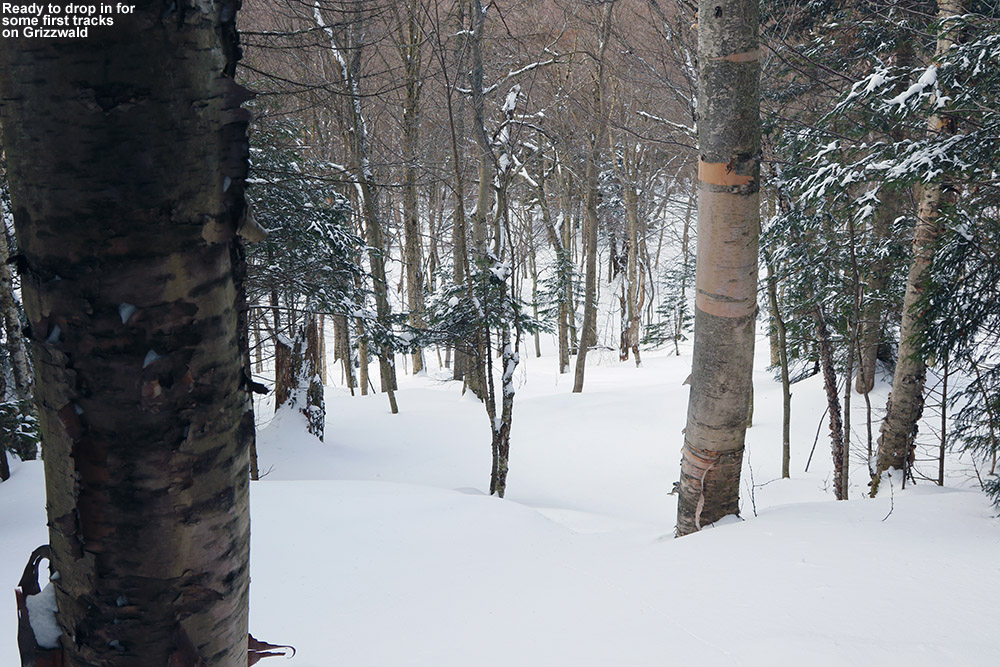
I left my skins on and zoomed across the flats toward Bryant Cabin. I didn’t stop inside, but instead continued along Gardiner’s Lane and up to North Slope to set up my final descent of the day. I stopped at the top of Upper JJ’s as my starting point. Since it was my final descent, I pulled out some tomato soup from my thermos, let it cool while I removed my skins, and then chugged the soup down and got on my way. The turns were beautiful, and I continued on Gardiner’s Lane, noting that there was a nice line above A1A that I hadn’t recalled seeing. I’ll have to check that out in the future. When I got to Grizzwald’s I found it completely untracked, and bounded my way down the steep pitch with some deep, fluffy turns. I contemplated a look at Alchemist, since it faces south and might be well preserved in this cold weather, but I saw what looked like just a track or two heading toward Gotham City and my skis just ended up pulling me that way. I skied Girls, and I think those might have been my favorite turns of the day. The depth and consistency of the powder came together perfectly for the pitch, and by the time I hit World Cup I was saying “Yes, Yes, that’s what I’m talking about!”… mostly to myself of course. I hit two more glades on the descent before I was down to Broadway, but I don’t really know the names of those – the snow was good to the very last drop though.
The GPS tracking data from today’s tour in the Bolton Valley backcountry plotted on Google Earth
I really can’t think of a tour I’ve done in the Bolton Valley backcountry that delivered such a huge amount of perfect turns in so many different areas, so this one really does go down as my best tour in that regard. The lift assist really allowed this tour to fit into a reasonable window of time while covering some good distances. There are really limitless combinations to do out there in terms of tours, but I know I’ll visit parts of this one again because it delivered so well.
Despite this winter’s low snowfall so far, the snowpack is quite deep along the high elevations of the Catamount Ski Trail and Bolton Valley’s backcountry network.
I parked down at the edge of the tennis court lots as usual, made my way up to the Wilderness Lift, and connected over to Heavenly Highway from the Wilderness Summit. Snow conditions were very much like yesterday – I checked the depth of the powder atop the base snow along Heavenly Highway and found it to be around 9 to 10 inches. The big change from yesterday was that there was nobody out on the backcountry network trails – Monday afternoon on a holiday weekend must have meant that most people had already headed home.
“It was so quiet that even the nearly silent shuffling of my skins through the snow had me feeling like a marching band crashing through a sleepy town in the middle of the night.”
Once past that first glade along the Catamount Trail, I was into what was for me, uncharted territory. I continued along the trail, which gradually rose as it headed generally north-northwest toward Bolton Mountain. One of the most impressive aspects of this part of the trail was seeing the impressive depths of snow that have built up, in what has really been a very low season for snowfall. The general area below the Catamount Trail junction with Raven’s Wind, which is sheltered like parts of Heavenly Highway, revealed evergreens that were just choked, buried, and ensconced with snow. Around every corner I was finding fantastic, gravity-defying deposits of powder. Once past the junction with Raven’s Wind, which marks the last outpost of Bolton’s backcountry network, the Catamount Trail began to level off and skirt along the eastern edge of Bolton Mountain. At over 3,300’ in elevation, this area marks the highest point on the entire Catamount Trail.
Ski tracks leading to the Cotton Brook area provide a rough sense of the snow conditions out along the Catamount Trail today.
I contoured along the southeast face of Bolton Mountain as the trail switched to a northeasterly direction; I couldn’t see the summit of Bolton Mountain (3,680’) through all the evergreens, but the steep rise in the terrain off to my left let me know that it was looming up there about 400’ vertical feet above me. As I continued to scan the elevated terrain to my left, I quickly noticed that the density of the evergreens had become sparser, and I began to see potential ski lines through the trees. I eventually decided that I’d gone far enough out on the trail for the day, and chose a spot to ascend a bit and see if I could start my descent up in the trees above me. The terrain was fairly steep, but there was that consolidated base below that top layer of powder, so I wasn’t wallowing in bottomless fluff as I broke trail. With the evergreens all around me, the air was deathly still. It was so quiet that even the nearly silent shuffling of my skins through the snow had me feeling like a marching band crashing through a sleepy town in the middle of the night. I continued generally westward and upward, following what looked to be the most open lines through the trees. The terrain began to flatten out ahead of me, and I could see on my GPS that I was approaching the Long Trail along the ridgeline; I decided that that was a good goal to mark as my turnaround point. I know that I was very close to meeting up with the trail when I finally stopped my ascent, as I was definitely on the ridgeline and the land clearly began to drop off to the west. I was tempted to go a little farther and make the trail connection, but it just didn’t seem worth it to lose elevation. It was after 3:00 P.M., I was well away from the Catamount Trail, and I was alone. It was at least generally downhill back to the Catamount Trail from my location, and there was no need to push my luck.
“Some trees even displayed that hanging moss that I’ve often seen in the mountains of the Pacific Northwest and British Columbia…”
I stripped off my skins and reversed my course, traveling along generally flat, ridgeline terrain at first, and negotiation a steep south-facing gully as well. When I’d finished crossing the flattest terrain and could see that I was about to begin the descent to the Catamount Trail, I stopped in a comfortable spot and pulled out some of my food supplies. I ate a Clif Bar and had a couple rounds of the hot tomato soup that I’d packed in my thermos like yesterday. That absolutely hit the spot. I definitely needed the recharge after throwing in all that extra trail breaking on top of the ascent of the Catamount Trail. The energy expenditure had been enough that I was getting a bit drained, and I definitely wanted something in the tank for the descent. Once I stopped moving, the silence around me was redoubled, and it was indeed eerily quiet. Such is the scene at times when one is alone in the deep woods of winter.
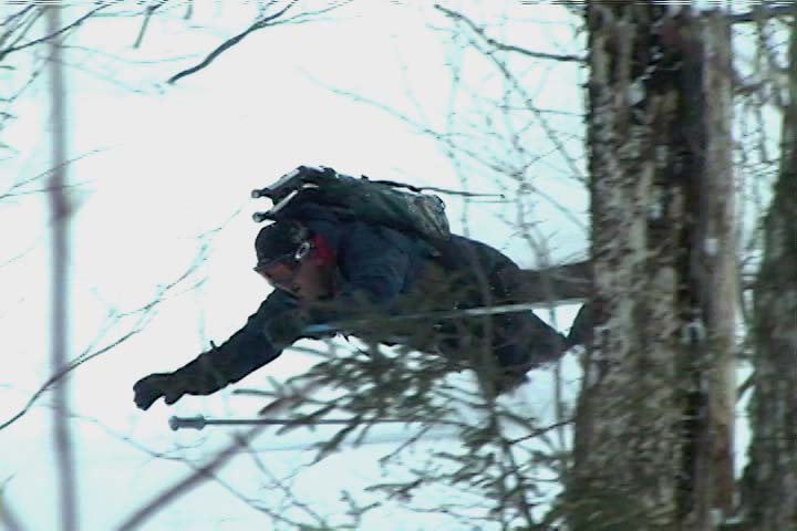
Catching a line through the trees high on Bolton Mountain
I packed up my food and gear and began the real descent through the evergreens. There were indeed some reasonably open spaces and nice turns, but it was steep enough that it really would have been better with deeper powder for the available tree spacing. The 9 to 10 inches that were there were OK, but I’d say something around 18 inches would be more appropriate. And, although the natural lines through the trees were good, they could be dramatically enhanced just by clearing off the all the dead branches that were still on the lower parts of the evergreens. That would be a great off-season project for someone to tackle, and the process could continue right on down below the Catamount Trailas well, because the terrain just keeps going. In any event, even in its natural state I’m keeping that terrain in mind for a place to visit after a reasonably big dump with depths of powder that will fit the pitch and spacing of the trees.
I popped out on the Catamount Trail and had begun to head back toward the resort, when I ran into the first pair of people I’d seen all day. It was a couple of younger guys, and they asked me if I knew the area. I said that I knew it fairly well, but when they asked me what lay to the north of where we were, I told them that that was out of my range of knowledge – I was currently the farthest north I’d ever been on this section of trail. In terms of descents, I said that I’d recommend descending back in the Cotton Brook area if they were unsure of where they were, because I knew that one could ascend back out of there quite easily. It was likely that one could traverse and get out from areas to the north as well, but one never knows just what the terrain would be like until they’re actually in there. I’m not sure what they ended up doing, but since it was well after 3:00 P.M. by that point, I hope they made an appropriate choice.
Views of countless snow-covered evergreens and even hanging moss as I travel through the high elevations of the Catamount Trail
I was tempted to do a little extra exploration on my return trip, especially as I looked at the vast expanse of evergreens below me. Some trees even displayed that hanging moss that I’ve often seen in the mountains of the Pacific Northwest and British Columbia; as if the deep snowpack wasn’t enough, the sight of the moss seemed to me like a real testament to just how much precipitation falls in the higher elevations of the Northern Greens. As much as it would have been nice to poke around, ultimately I wasn’t willing to explore a descent down into the Cotton Brook area with the time of day, so I descended back toward the resort on the Catamount Trail itself. The trail isn’t very wide, so the descent below Raven’s Wind was quite a hoot. Let’s just say that I’m glad that I didn’t “run” into anyone ascending at that time of day. It’s definitely an exhilarating descent back toward the main glade though if you can catch it without any uphill traffic. I enjoyed a descent of the main glade back toward the Cotton Brook Trail junction, but despite the decent amount of powder, the combination of tracked snow, irregular surface underneath, and some previously work by the sun, made it rather challenging and nothing special in terms of flow. It’s definitely time for another storm.
I cruised quickly back along the Catamount Trail to the Bryant Cabin area, and headed right onto Gardiner’s Lane and North Slope. I was determined to find that glade that I’d missed with E and the boys yesterday, and after a bit of searching, I did. I made another mental note on the entrance to set myself up for next time, and had a fun ride down through there. When I finally got back down to the lower Nordic trails, I saw a couple of other people, but amazingly that was it for the entire tour of almost six miles. I can’t wait for my next chance to get out in the farther reaches of the Catamount Trail and explore it further.
There was some fantastic powder out there in the Bolton Valley backcounty today.
After a great powdery outing with Dave up on Bolton’s Nordic/backcountry network on MLK Monday, our next snow event began the following day. It was one of those low pressure systems in the Great Lakes that redevelops as a coastal, and as has been the trend this season, Northern New England was outside of the areas of heaviest precipitation. However, we did manage to get some snow out of the event. While there was no snow falling in Waterbury at the house when I left in the morning on Tuesday, a couple of hours later it had started up in Burlington. When I got home that evening I found 4.2 inches of new snow on the snowboard, and it turned out to be some reasonably dense, base-building material.
In the valley we wound up with 6.5 inches of snow comprised of 0.63 inches of liquid with that event, and then a similar system came in for yesterday. We were even farther out of that one though, and would up with just 1.6 inches of total snow at the house. As expected, the mountains did somewhat better, and Bolton had picked up over a foot of snow for the week.
The big weather event for this weekend isn’t snow however, it’s the cold. Highs are expected to be around 10 F today, and then perhaps not even get above zero tomorrow. E and the boys decided not to ski based on the cold forecast, but today’s temperatures seemed like they would be pretty nice for a backcountry tour. I waited until about midday for the temperatures to warm, and warm they had! Driving toward Bolton, the temperature was almost 20 F in the valley, and it seemed quite a bit warmer than initially thought. Even up in the village above 2,000’, the temperature was already 10 F and rising.
Kicking off my tour, I headed up Bryant as usual, and was treated to blue skies and lots of white trees. I could feel that the temperature was cooling down as I gained elevation, but I still had my hat off at times to keep cool. Once I reached the Bryant Cabin I assessed some tour options. Ty was having some friends over for a birthday party starting at 4:00 P.M., and I still had to do some grocery shopping on my trip home, but it looked like I had time for a longer tour that just a Bryant lap. I decided to head out north for a bit along the Bolton-Trapp/Catamount Trail and catch some turns off there.
The trip through the flats to the North of the cabin was fairly quiet, with more white trees and lots of deep snow visible on the steep slopes to the east. I saw one other skier in the flats on what looked like lighter touring gear, and then I saw another pair of skiers at the top of the drop in for the Cotton Brook trail. I kept going and assessed some glade options on the high side of the trail. There were a few tracks, but plenty of lines that hadn’t been visited, and the powder looked fantastic both above and below. To read about the descent and see all the pictures from the day, head to the full report from the Bolton Valley Nordic & Backcountry Network today.
Jay enjoying some powder during today’s ski tour on Gilpin Mountain after Jay Peak recently received 2 1/2 feet of new snow
For years I’ve driven along Route 242 to get to Jay Peak, often remarking about the intriguing ski terrain that dropped to the road from both sides. This was always on the way to ski the resort of course, and thoughts of exploring those backcountry goodies had to wait. Since Jay Peak had received 2 ½ feet of new snow in the past few days (much more than anyone else locally for us), and it was a holiday weekend, I decided it was time to explore the goods off Route 242. This realization came to me on Friday morning when I awoke, and I soon sent out a secret message to a local band of agents informing them of a Mission Impossible. This mission, which James, Erica, and Dave chose to accept, wasn’t really all that impossible, it was more just unknown. Mission Impossible sounded fun though.
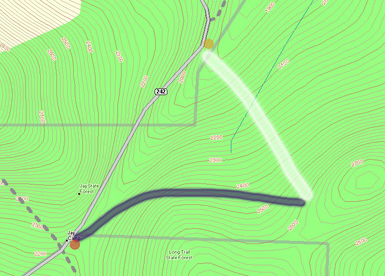
A topographic map of the Gilpin Mountain area showing Route 242 (gray) and the approximate ascent (thick blue line) and descent (thick white line) routes used during today’s ski tour
At the crest of Route 242 (elevation ~2,250′), The Long Trail crosses the road, and along with the trailhead there’s a parking area (see the red dot at the lower left corner of the topographic map provided with this report), so this appeared to be a good place to start a hike. My initial plan was to head south along The Long Trail (note on the map where the gray-dashed Long Trail heads south from the red dot) toward Domeys Dome (elevation 2,913’ – not visible on map) and ski down from there to Route 242 where we would have a second car waiting (elevation ~1,500′ – off the map to the south). This would provide a roughly 1,400′ vertical run, with a calculated pitch of around 23 degrees.
When we actually arrived to surveil the area though, we discovered that what looked good on paper didn’t look as enticing in real life. The parking at the bottom was quite far away, and the slope leveled out too quickly to a very low angle. In 10 degree temperatures and brisk winds, we gathered together in one of our cars at the top of Route 242 and consulted the maps for new guidance.
We decided to drive the car along Route 242 to the northeast (in the direction of the Jay Peak base area) as the road descended toward the resort, while we looked for potential ski lines. There were plenty of lines off to our right, as well as a second parking area for cars (yellow dot on the map) at the next low point of Route 242 (elevation ~1,950′). This setup seemed almost too perfect. I say “almost”, because unfortunately The Long Trail doesn’t go in that direction at all, and we assumed we’d have to blaze our own path through deep powder to get to where we wanted to go. We had seen what appeared to be a trail heading off in the direction we wanted, very wide (10 feet or so on average), but we were still unsure if it would work for us. As we got closer, we could see that someone already had a skin track heading that way; we’d found our hiking route.
From the top of Route 242, we got our gear together, threw on our snowshoes, and headed out along the trail (our ascent route is roughly marked by the thick blue line on the map). The image of the group heading out shows the general look of the terrain at the start of the trail. I soon noticed from the blazes that this was The Catamount Trail (the HUGE cross-country ski trail that travels the whole length of the state). The upward slope of the trail was very slight, but as we continued on our ascent, Route 242 quickly fell away to our left and we could watch the vertical drop for our potential ski run grow rapidly. At an elevation of around 2,400′, we broke uphill of The Catamount Trail (following the switchbacks of another skin track) to gain some additional vertical. It turned out that other folks had been in the area today, as shown by the skin tracks, ski tracks, and the people themselves. We continued to hike up to around the 2,600′ mark, and then as the slope started to mellow out, we decided to boot up and test out the terrain. A group of about five Telemark skiers passed by on their way up, one of them deciding to cash in at that point and start his descent as well.
Dave slices his way through some branches as he encounters a brushy area on one of our ski runs.
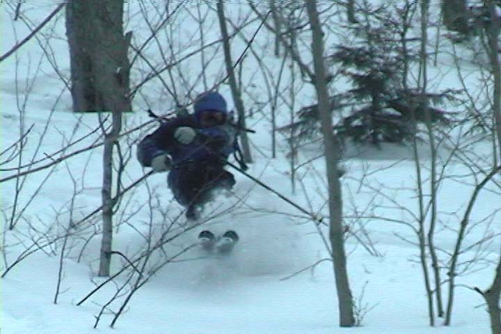
It’s amazing to think that last weekend had been a situation of rain, warm temperatures, and a refreeze that turned the entire snowpack into a solid, crusty mess. From where we were standing, it was basically bottomless powder, a situation in which removal of snowshoes or skis meant trouble standing. The pitch of our descent started off mellow, with various areas of hardwood glades and some underbrush at times. The snow was nice and light; I’d estimate its density at somewhere in the 5-7% H2O range. The slope gradually got steeper as we picked lines along the way that looked good and headed in the general direction of our lower shuttle vehicle. Our general descent route is marked by the thick white line on the map. Even with the deep snow, some areas had enough underbrush that they made picking lines difficult. Some areas we quite clear, but a bit of scouting was needed to find them. James picked direction with his usual finesse, and guided us right down to the parking area and our waiting vehicle (Dave’s pickup truck).
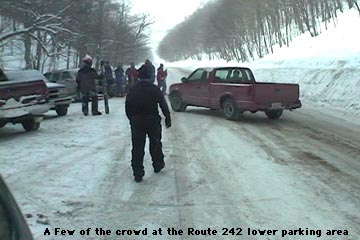
A scene from the lower parking area on Route 242 where many people finished off their ski runs, with skiers of all types constantly coming and going
Our total vertical skied was approximately 700 feet, which was a nice run for only about 400 vertical feet of very easy hiking. At the parking area it felt like the local version of Grand Central Station for backcountry skiing. There were numerous cars, lots of people hanging out, and skiers pouring down off of both sides of the road enjoying the powder. James said it felt like a local backcountry Mecca (in reference to the number of people). Although a few of the people were from our side of the road, most came down from the Jay Peak side, riding the lifts and then catching a beautiful long run all the way down to Route 242. Some people had cars waiting for them, some hitched rides, and some looked like they had no idea where they were. It was an awesome scene to see though, with all those folks out there enjoying the snow. I’m thankful we weren’t skiing the other side of the road though (the Jay Peak side), as the number of skiers on those slopes had even that vast amount of terrain tracked up quite well. I had always thought of heading that way when skiing Jay Peak, and had no idea how many people did it. There was a continuous flux of people coming through that area all day long, with cars pulling in, parking, leaving, people looking for rides, giving rides, looking for people that they had lost, etc. etc. etc.
Catching a ride back up to the top of the pass in the back of Dave’s pickup truck
Using our vehicles, we shuttled our crew up to the top of the pass, and started for another run from the upper parking area. Unlike the lower parking area, there were only a few cars there, and no people. The wind was blowing and the temperature had stayed around 10 degrees the whole day, but the sun had come out for a while during our first trek, and it had made that a great hike. We had a snack in the car, and headed off along The Catamount Trail for round two. Our first run had tuned us into the lay of the land its terrain nuances even better, and now James had plans for some even sweeter lines. We hiked the same general route (much easier at this point with the presences of our tracks and those of numerous others who had been up). We cut upward off The Catamount Trail a bit earlier, and topped off near the same elevation as before. This time we found some lines that were even more open, although we did still had to pass through some brushy sections.
James helping out with some footage for our crash reel!
I’m not sure how good the ski touring in this area would be with low snowpack, since even with four feet of base, there was still brush in some areas, but it was certainly good skiing with our usual midwinter base depths. Some of the most fun we had was due to spectacular falls, with all four of us getting in on the act by diving into the powder. We shot about 30 minutes of video, hopefully enough to have a segment in this year’s ski movie. We’ll have to see, but either way, we got some of our best falls for this season’s crash reel! 🙂

 It’s amazing how one storm simply brought the backcountry conditions from very early season stuff that I hadn’t even contemplated skiing, to something that skis like a top notch midwinter snowpack. And it’s not as if this last storm cycle was a 3 to 4 foot monster. The snowpack we were skiing today is only in the range of about 20 inches, but apparently it’s just laid down so well that it does the job. I’m sure there are steep slopes out there with lots of big obstacles that are nowhere near ready, but the typical glades we skied on the Bolton Valley Backcountry Network today were in great shape.
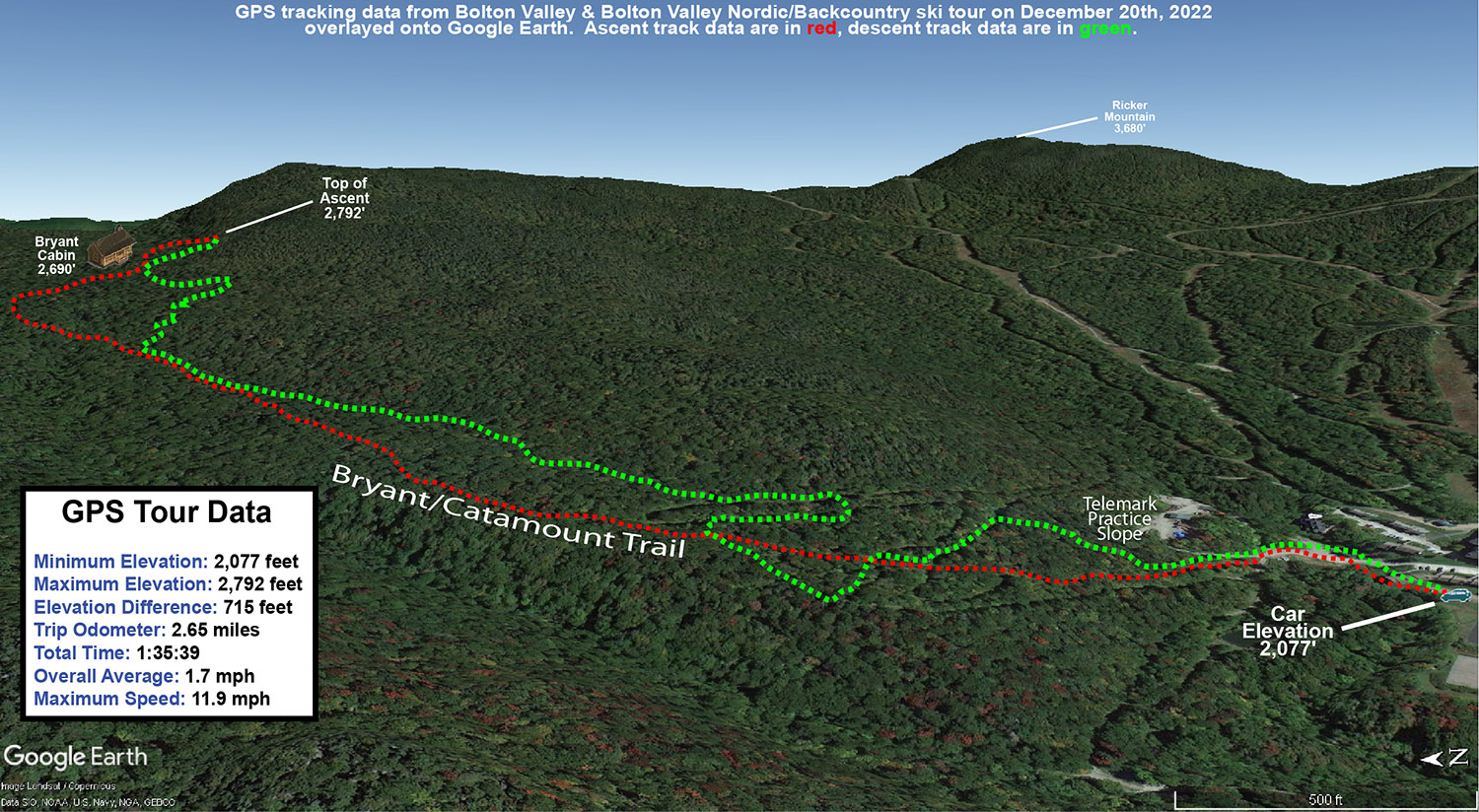


