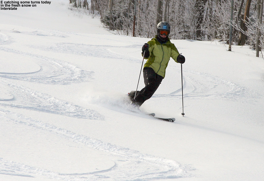
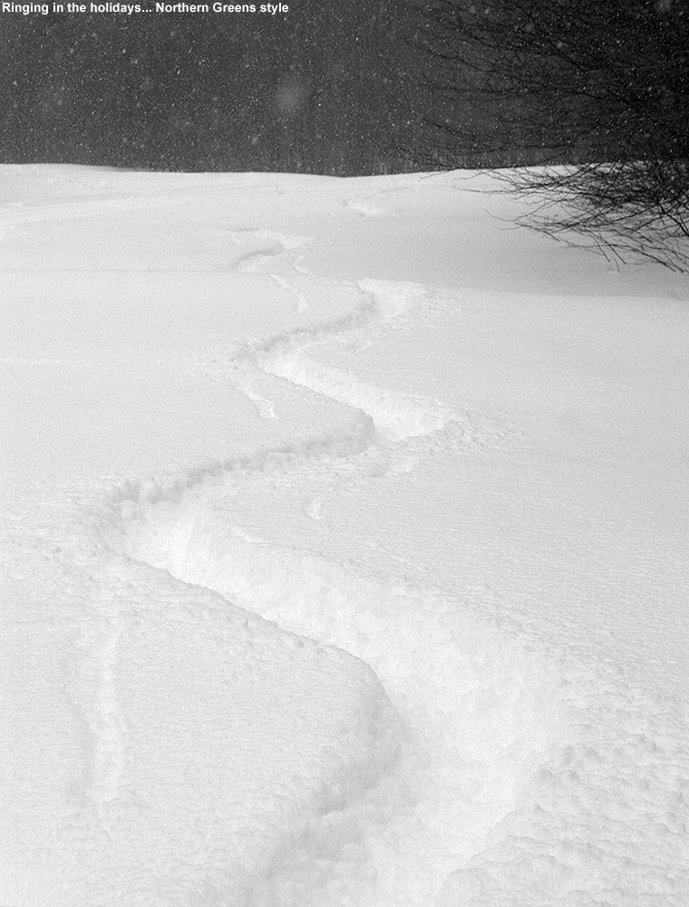
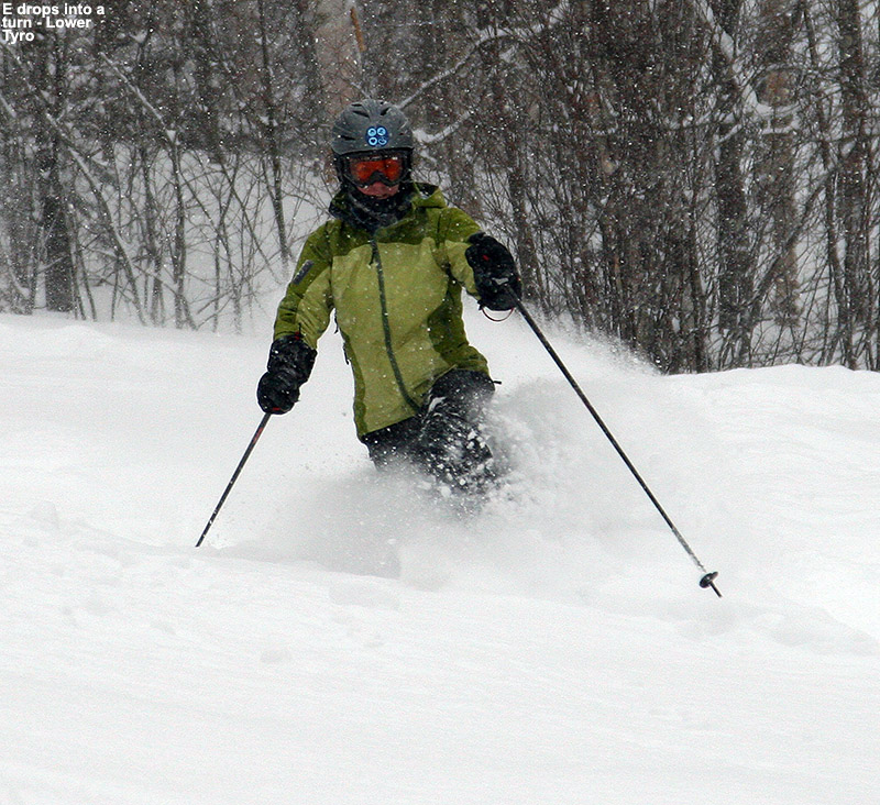
E showing how its done in the powder at Bolton Valley today
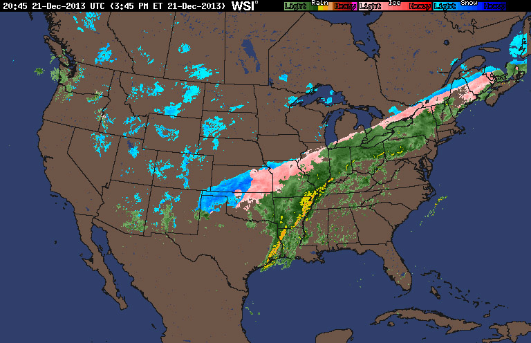
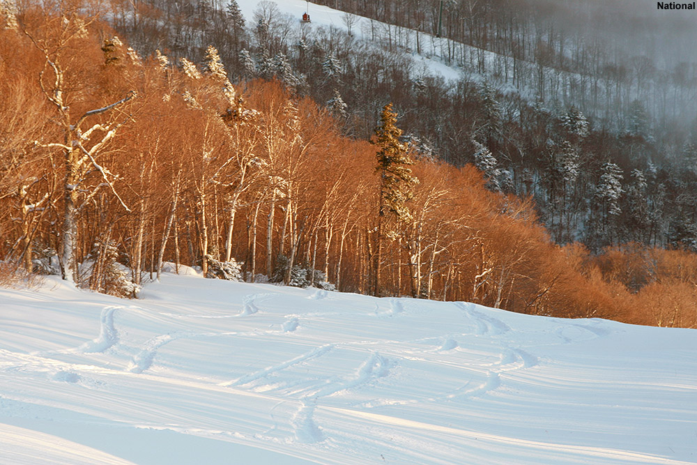
An Alberta Clipper hit the New England region yesterday, dropping up to 10 inches of snow in Northern Vermont and continuing the process of covering up surfaces that were hardened by the big mixed precipitation event earlier this week. We had a couple additional rounds of light snow prior to yesterday’s storm, but there still hasn’t been enough new snow to resurface steep, icy terrain. As such, Bolton Valley only has their core set of trails open on the main mountain. I had fun on those trails on Saturday, but it’s still a limited number of options for runs, and with a good amount of new powder available, we decided to earn some turns and get some fresh tracks today. The Wilderness Lift isn’t running yet for the season, so we decided to pay that terrain another visit. Ty, E, and I had a great time there back on November 30th, and with the current firm, icy subsurface, we knew that the moderate pitches and relatively high elevation of the lower Wilderness area trails would be a good bet for powder skiing today.
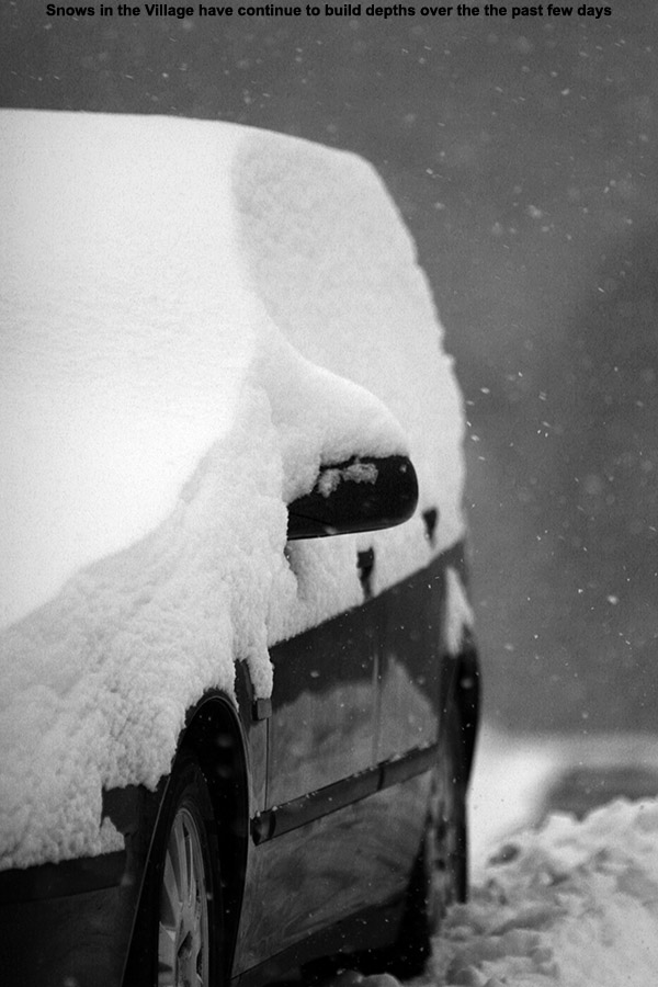
Now that we’re back into a more consistently wintry weather regime, the Northern Greens snow globe has kicked in, and we’ve had a fairly consistent supply of light fluffy snows in the air. It’s not really substantiating the base snow, but it is creating quite the quintessential Vermont winter scene for holiday visitors, and it’s topping off the slopes with some serious softness. Another burst of flakes was just kicking off when we left the house to head up to the mountain today after lunch, and the snowfall intensity increased as we headed up toward the resort. Up in the Village we encountered temperatures in the low 20s F and steady light but accumulating snows. There were plenty of cars in the parking lots, but since spots were opening up with early afternoon departures, we secured a spot right at the north end of the upper lot.
“The descent was a peaceful glide through silky smooth powder, with only the occasional touchdown on the old base.”
We headed up to the landing on the northwest corner of the main Village complex, and got our gear ready. Quinn passed through and gave us a heads up on conditions – below the powder was a slick, icy base as we’d suspected. We followed a nice skin track up Lower Turnpike, and there were a few sets of tracks on the trail, but a lot of fresh snow remaining. A couple of guys came down the trail and let us know that the steep upper sections weren’t worth the effort because of the ice, right in line with what our beta was suggesting. Depth checks at the start of the ascent revealed 5-6” of powder, which represents the accumulations from this recent clipper and the couple of small bouts of snow that preceded it.
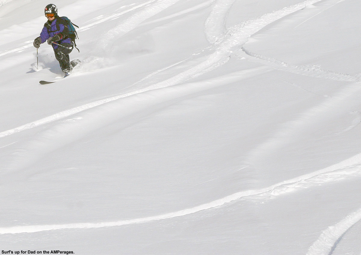
“…you could really feel the way the floatation afforded by our fat skis was letting us ride a bit higher and faster in the powder on those lower-angle pitches.”
We skinned up among steady flakes, enjoying the snowy views of evergreens around us, and when Dylan called for a break ,we stopped at the first crossover to the Wilderness Lift Line at 2,500’. I checked on the conditions on Wilderness Lift Line, and found that it had been hit with wind harder than our last visit – it was clear that although Turnpike had a few tracks, it was the better choice for snow quality. With Ty leading the charge, we continued on up to ~2,750’ before finally putting a halt to the ascent because we were getting into icy, scoured terrain. The snow depth up at the point had increased to roughly 7 inches.
The descent was a peaceful glide through silky smooth powder, with only the occasional touchdown on the old base. The pitch and powder were essentially perfect, although the powder was deep enough that Dylan would sometimes have difficulty keeping his speed up. Dylan’s Telemark skis (Völkl Gotama Juniors) are fairly wide, but nothing like the Black Diamond Elements and AMPerages that E and I were using, and momentum issues aside, you could really feel the way the floatation afforded by our fat skis was letting us ride a bit higher and faster in the powder on those lower-angle pitches. I was curious to see if E had noticed the effect, so I asked her how she felt about the speed of her skis on the descent. She initially thought that they were very fast, and figured it was because they haven’t been used for too many outings and had been waxed. I explained that a good part of that was actually from the floatation that the skis provided. Ty invented a new descent technique where he would kneel all the way on the tips of his skis with both knees, and in the powder it gave the illusion that he was just kneeling in the snow with no skis and flying down the mountain. We’ll have to get some video of that at some point, because it’s quite a hoot.
Ty dives in
We ended our descent back at the landing on the northwest corner of the Inn, and discovered that it’s a great spot to be if you want to catch up with what’s going on at the resort. After seeing Quinn at the start of our tour, we ran into Cam and later Josh at the end of the tour. We got to chat about the current state of the conditions, being happy that there are still great options out there for powder, but hoping that we can get some larger storms in here to start building the base. We’re in an OK pattern for maintenance over the next couple of days, and there’s a chance for getting in on snow from a coastal system as we head into Sunday night. We’re certainly a bit fat to the northwest to really jackpot with that storm, but if we can get some base-building synoptic snow out of it, it will really be a step toward terrain expansion.
Making use of what Mother Nature delivered to get in some fun turns today at Jay Peak
We’ve been up at Jay Peak with family leading up to Christmas, and today we got out on the slopes for a few turns. The weather hasn’t been great for the ski conditions, since we just had an extended storm with plenty of mixed precipitation. The storm did bring some snow with it, but also plenty of other precipitation that ultimately led to a hardening up of the slopes. There really wasn’t much to inspire one to get out on the hill today, especially with colder temperatures on the way, but it was snowing when we arrived last night, and that piqued my interest at least a little.
When it finally came time to decide if we wanted to ski today, the boys were game. And since our RFID cards that serve as our room keys and provide access to other areas of the resort, also serve as RFID ski tickets, there wasn’t much of a downside to hitting the slopes. Today was also a chance for the boys to ride the tram, which was already closed for the season the last time the boys and I came to Jay Peak for lift-served turns. Temperatures were starting the day in the mid teens, which wasn’t too bad, but they were expected to drop throughout the day, so we decided that we’d best served by going for our turns in the morning before it got colder.
We started out at the moving carpet, where Luke and Lilly were having their first ski experience ever. We helped Marc and Jill get them going with some tips, and then once they started getting the hang of things, Marc joined up with E and the boys and me for a run on the Tram. The boys finally got their tram ride, and were impressed with how high and fast it traveled. From the summit we headed down Northway to Ullr’s Dream, and conditions were simply heinous up top. The snow was hard and icy, and I’m glad I’d sharpened our skis, but I’m not sure how much good it did. That’s sort of par for the course anyway with the way the wind blows up there, but the recent storm certainly didn’t help in that regard. We didn’t find much to inspire us to really take another run until we got down onto Kokomo along the lower elevations of Ullr’s Dream. Down there, an inch or two of powder has settled in, and combined with the modest pitches, we were starting to encounter some soft turns
The end of that run inspired us to make a second, and this time we used the Metro Quad, which is low, out of the wind, and down in the warmer elevations. We were hoping to head over toward Deer Run, but when we found the terrain on that side of the lift roped off because of snowmaking, we moved toward the Interstate side of the lift. That turned out to be just what we were looking for. Since the vast majority of the people on the trial were there for the terrain features, they were totally ignoring the large area of untracked snow off to the skier’s left. We found an inch or two of fresh powder over a smooth base, and turns were quite inspirational. It was the sort of discovery that definitely injects some excitement into the day. It was so much fun, I felt that we had to do it again. Of course with the rest of the family hungry and eager to get to the water park, I was by myself on that next run, but it was just as sweet.
It’s snowing again tonight as I write this, so as is par for the course for the Northern Greens, they seem to be starting to nickel and dime their way back to nicer conditions. I don’t think we’ll really have time to ski tomorrow with the Christmas Holiday, but I bet our tracks will be covered up again for tomorrow, and there should be fresh turns out there waiting for someone. I’ll update this report with more info on the whole trip as time goes on, but indeed there’s just way more to do here than time often permits. I will say one thing that really impressed and surprised me though, is that with the addition of the new Stateside Hotel, there are now 17 eateries of various sorts up here at the resort. We tried out three new food options on this trip that we hadn’t before, so I’ll talk about those when I add a bit more to this trip report.
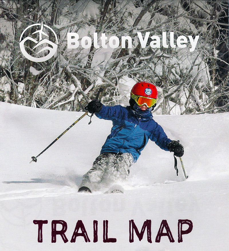
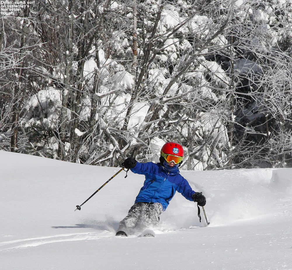
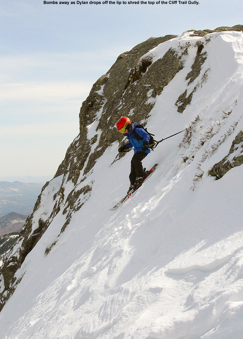
Congratulations to Dylan for making the cover of the new 2013-2014 Bolton Valley alpine trail map!
When I was up at Bolton Valley on Saturday, I glanced over at the trail maps and brochures near the front desk as I often do, and saw that the new editions were out. Upon closer inspection, I realized that Dylan was on the front cover of the maps – in a picture taken during our December 28th outing from last season. That was actually one of my favorite shots from the 2012-2013 season, as I was pleased with the snow, lighting, composition, and Dylan’s positioning, so it’s great to see that Josh and other members of the team chose it for the trail map cover. Ty kicked things off in the 2011-2012 seasonwhen he was featured in many ads and made the cover and interior of the Bolton Valley brochure, then last season the boys both made the covers of the map and brochure, and it’s great to see that one of their images was used again for the newest map. Congratulations to you Dylan on another cover shot! It pays to listen when Mom and Dad when they’re always telling you to keep those poles up and weight centered, and we appreciate all the patience that you and Ty have during the countless photo sessions each season. We’ll certainly be thinking of you each time we use the map this season!
The original shot of Dylan from December 28th, 2013 at Bolton Valley
Despite the dim light, there was great soft snow out there at Bolton Valley today
A strong frontal boundary has been draped across Northern New England for the past day or so, and this front is huge – it extends all the way up from the lower Mississippi Valley into northern Maine, New Brunswick, and beyond. On the south side of the boundary there’s lots of rain, and on the north side there’s snow and various forms of mixed precipitation. Here in Northern Vermont we’re really walking that line, and thus we’ve been treated to quite an amalgam of precipitation types. We had some snow on Friday morning, then some rain later in the day, which transitioned to freezing rain in the evening and overnight. Fortunately, the temperatures warmed up to around 40 F this morning, the precipitation shut off for a while, and indeed it was a wonderful morning to be outside.
The frontal boundary draped across much of the country is producing all kinds of weather
Naturally, the nice weather got me thinking about skiing. I didn’t actually expect to be doing any skiing this weekend with on all the messy precipitation out there, but the morning lull seemed too good to pass up. I checked the radar and saw that there was about an hour or so before the next batch of precipitation moved in, and that would be plenty of time to work out the legs for a bit on the Telemark skis. I also knew that the snow was going to be nice and soft, because the cold air has generally been in the valleys, and in fact the mountains have been warmer. The Bolton Valley Weather Station at 2,100’ was reporting temperatures in the mid 40s F, and that would definitely soften up even the toughest snow.
“…on my next trip I took Alta Vista, and that was the run of the day.”
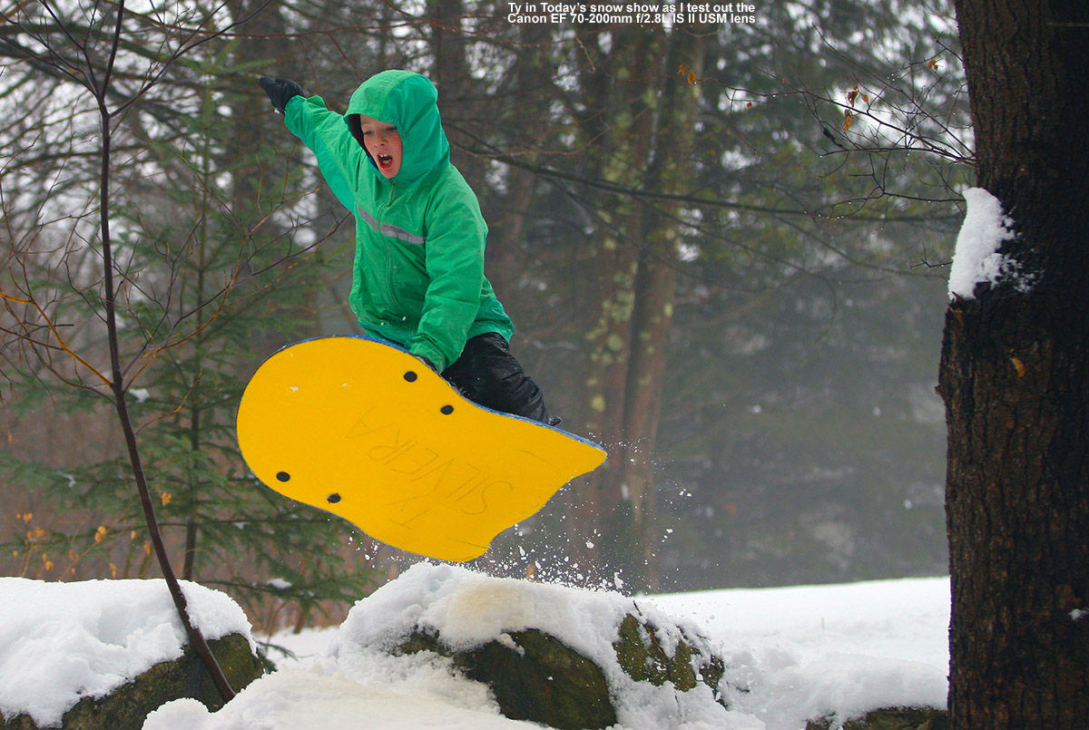
I couldn’t convince anyone else to go up to the mountain with me, since the boys were having way too much fun sledding in the yard, and even with the lull in precipitation, E wasn’t thrilled with the weather situation. I had to go it alone, so at around 10:30 A.M. I got my ski gear together and loaded up the car. I was just about to drive out when I got a bit distracted. I saw the boys making runs on their sleds, and they were having a ton of fun. After we talked for a bit, we decided to have them head down onto one of the lower runs on our property that had a fairly large jump. My friend Chris has lent me his Canon EF 70-200mm f/2.8L IS II USM lens for some testing, and since we’re unfortunately past the fall soccer season, this seemed like the perfect opportunity to put the lens to work. Let’s just say that f/2.8 rocks, and even with only winter solstice light for my 30D to work with, I was able to get down to around 1/2000 sec at ISO 200. The boys put on quite a show, and I was able to capture some nice shots during the test.
The boys were out really enjoying the snow today.
We probably spent an hour shooting sled jumps and putting the lens through its paces, and when we were finally done, I reassembling my gear and prepared to head up to the mountain. Within moments, it began to rain, and of course my weather window had closed. I had to wait until early afternoon, but eventually another window opened. It wasn’t as precipitation free as earlier, but it looked like it was going to be my best shot to get in some turns. Although I knew the weather was still warm up on the mountain, I wanted to get going – our temperature had dropped to 35 F at the house, and I didn’t want to have to deal with ice on the roads if the temperature dropped too low. As I drove west down the Winooski Valley, the temperature fell to 34 F in Bolton Flats, and finally 33 F at 340’ in Bolton, at the base of the Bolton Valley Access Road. The temperature hung there as I drove upward, and once I got above 1,000’ the temperature began to increase. I proceeded to drive up through several very interesting bands of fog and clouds, and by the time I got up to the Bolton Valley Village at 2,100’, the temperature had risen into the low to mid 40s F. Getting out of the car felt like stepping into the bathroom while someone was showering.
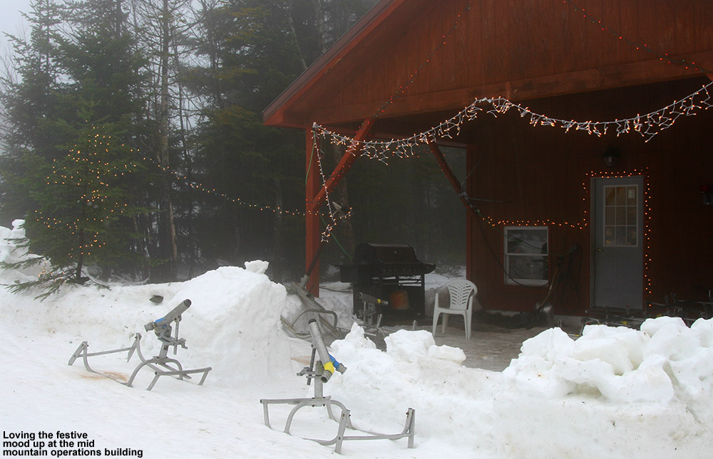
Holiday spirit at mid mountain today
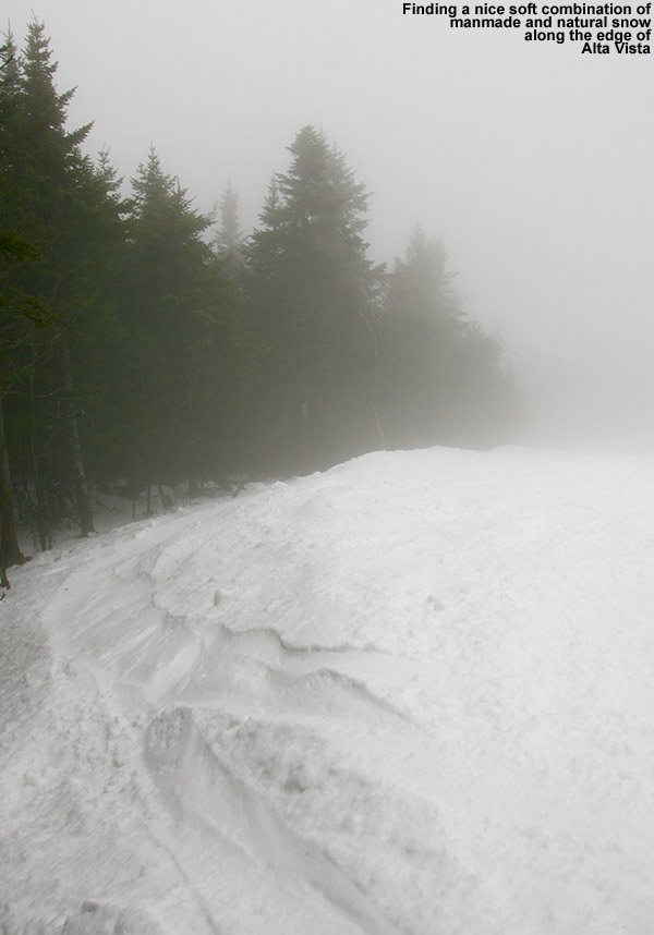
With low clouds and on and off light rain, it wasn’t surprising that just a handful of people were out skiing, but the snow looked good. I hopped on the Vista Quad, and headed down Spillway Lane for my first run. I’d heard that Vermont 200 and Schuss were open, but I found their ropes up as I approached them. The coverage didn’t look too bad at that point, although with the soft snow I’m sure that too much skier traffic could have been detrimental. I continued on the Sherman’s Pass route instead, finishing off with a good run down Beech Seal that had me working hard simply because of the low visibility. You really had to be on your toes because you could only see a turn or so ahead.
Since Vermont 200 and Schuss were closed, on my next trip I took Alta Vista, and that was the run of the day. On the skier’s left, there was a beautiful mixture of soft manmade and natural snow, and the turns were great. Ty loves that area, so I wished he’d been there to ski it. It was good enough that I had to hit it again before I finished up, so I burned the legs for another round. The snow was soft everywhere, and the runs were skiing quite well, although if you ventured too far off the groomed runs into the natural snow it was mushy. You could also see that some of the natural snow trails were losing cover due to the warm conditions, and it’s funny to think that snow was probably melting up on the slopes more than down in the valley.
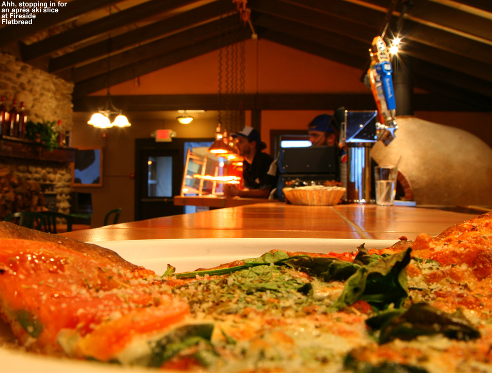
Since I hadn’t eaten lunch, I stopped in at Fireside Flatbread for a slice, and got to catch up with Josh Arneson. I told him I’d just seen the new trail maps with Dylan on the cover, and the picture was great. Not surprisingly, it was just me and a few employees hanging around, and it had that pre-holiday vibe. The pizza was great as usual – I went with a margherita-style slice.
When I headed back down to the valley, the temperature had dropped a couple of degrees in the Village, and I found the same 33 F at the bottom of the access road. Things were definitely right on the border of freezing up though – when I stopped to gas up at the Bolton Store, the pavement at the gas station was in a half frozen/slushy state, and you could tell that it was on its way to hardening up. Back at the house, the temperature had dropped to 33.1 F, and it wasn’t long before we were back below the freezing mark. There’s the potential for more freezing rain tonight, so we’re hoping it’s minimal enough to not promote issues with trees and power lines. Even though this storm has been messy, it’s likely that many areas will get a net gain of liquid equivalent in the snowpack to substantiate the base. However, we’ll need additional snow to cover up the firmness when the mountain temperatures drop.
I stopped in at Bolton Valley this morning to check out the snow and make some turns, eager to see how the Timberline area was doing. Up to this point I’ve only skied the main mountain, because the snowpack down at the Timberline elevations was just a bit too marginal. The snowstorm we just had over the weekend was fairly significant though, with close to a foot of snow for the ski resorts in Northern Vermont, and with additional small rounds of fluffy snow topping things off this week, I suspected that Timberline would finally be ready for some turns.
Temperatures have warmed up significantly from where they’ve been over the past several days, and this morning’s valley temperatures in the mid 20s F were very nice. The shot of snow that we picked up this morning in association with a passing warm front had essentially dissipated by the time I was driving up to the hill, and I found just cloudy skies as I geared up for my ascent.
“…I set the AMPerages together alpine style, then schussed the next 30-40 feet of the headwall before dropping into Tele turns in the fluff along the skier’s left of the trail.”
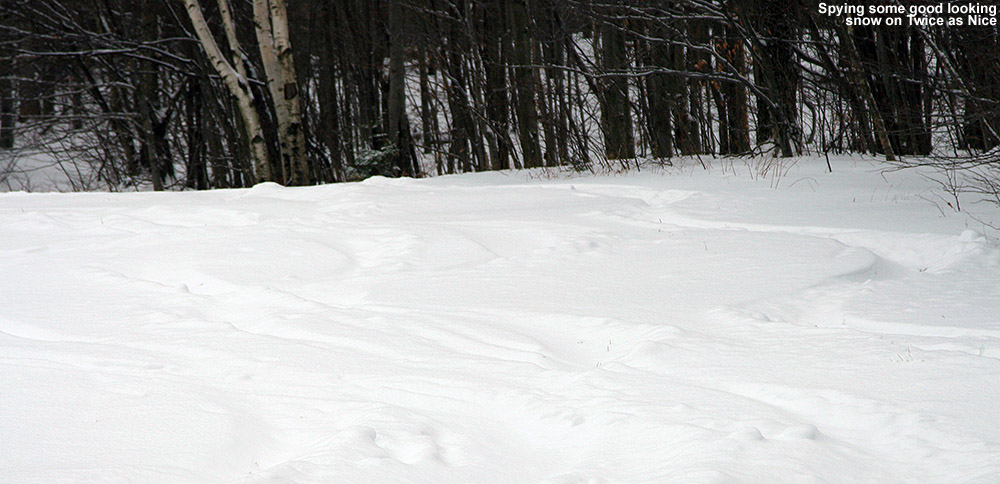
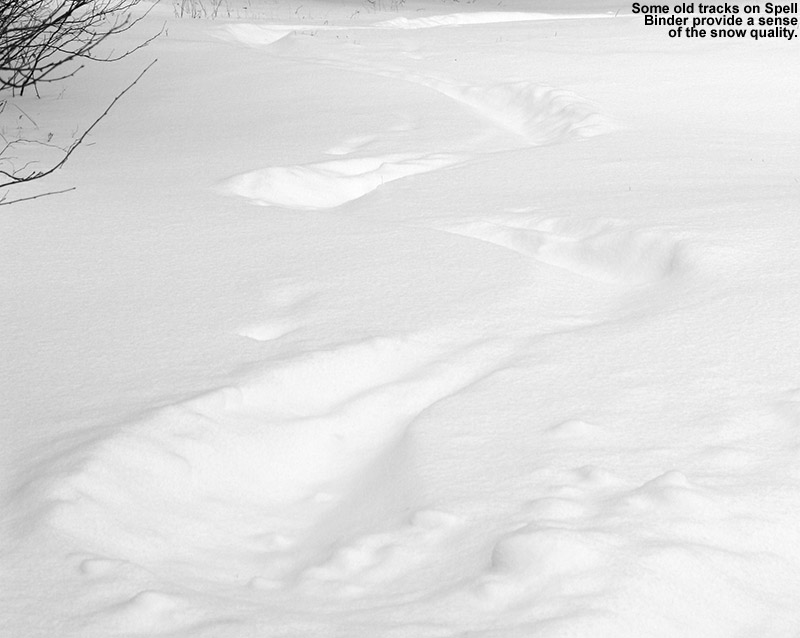
Right off the bat as I began my ascent behind the Timberline Lodge, I started probing the snow to get a sense of the depths and consistency. I found roughly 10 inches of powder in undisturbed areas just above the lodge, and it was indeed nice, but it only had a bit of a density gradient to it. The more surprising thing was that there was little if any base below the powder. There must not have been much snow down at those low elevations before the weekend storm. I followed a nice skin track that took the typical route, wrapping around the lodge and heading up the skier’s right of Twice as Nice. I saw some great-looking powder along the skier’s left of the trail which is more protected from the sun, but there continued to be little if any base along the skin track. That lack of base had me concerned, but once I was above 2,000’ it started to kick in even in the sunnier areas. I was getting snow depth readings of roughly a foot above that level, and there were at least a couple inches of dense base snow. At the mid station I looked toward the upper section of terrain and could tell that with the wind, it wasn’t really going to be worth the additional hike. I traversed across to assess the descent options, and although the tracks on Twice as Nice looked good, Spell Binder looked a bit better.
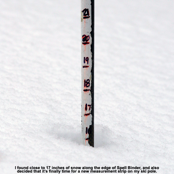
I switched over for the descent and side-stepped cautiously down the first 20 feet or so of the headwall. I could tell that the snow was thin in that area due to wind scouring, but below that it was much better. I had enough confidence in the coverage to ski the next section of the headwall, but I wanted maximum floatation just to be safe, so I set the AMPerages together alpine style, then schussed the next 30-40 feet of the headwall before dropping into Tele turns in the fluff along the skier’s left of the trail. It felt like the perfect melding of alpine and Telemark technique, and dropping the knee into those lower turns was oh so good. I did a couple of depth checks along the edge during the descent, and generally found at least a foot of snow, with up to 17 inches in one of the deeper spots. The powder there had that fantastic density gradient that delivers great turns. As is often the case, the Timberline area has managed to deliver some of the finest turns of the season so far.
Gorgeous Timberline fluff
Down at the car, I ran into Brian, one of our graduate students, who was also catching a morning ski constitutional before heading to work. He’d taken Twice as Nice, and said that he had to be on his guard at times. He’s bigger than me, and his skis weren’t quite as wide as mine, but based on our conversation I think I’d give Spell Binder the nod on conditions. Temperatures warmed up to around the freezing mark down in the valley, and that felt nice. We’d supposedly got a big storm, or series of storms coming through the area this weekend, and although there’s going to be a lot of mixed precipitation, it could be a good snowpack builder as well. We’ll just have to see how it plays out.
Yesterday E had her training day for our school’s ski program at Stowe, and boy was it cold – it was below zero F for the entire morning. I’d sent E off with plenty of hand and foot warmers, and she made use of them. She actually cracked the lens in her goggles toward the end of the morning, but by then everyone was just about done anyway. I don’t think there were many takers for afternoon turns once the requisite training items were covered in the morning.
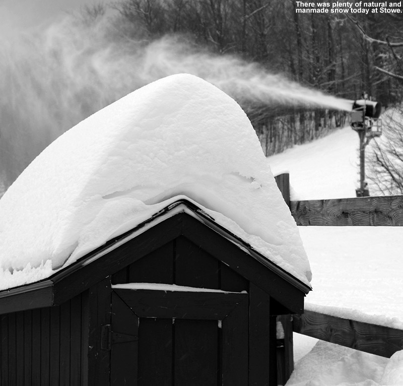
Things were a little different for my training day today – temperatures were rising through the teens F, and oh yeah, there was a bit of a snowstorm in the intervening period. This storm was one of those that comes out of the Ohio Valley and redevelops off the New England coast, and it brought up to 19 inches of new snow for the Vermont ski areas. Snowfall totals were a bit lower for the Northern Vermont ski areas, generally approaching a foot, but as my snow analyses had shown, there was plenty of liquid equivalent in the snow; as of this morning, we’d picked up close to ¾ of an inch of liquid in the snow and the density was close to 10% H2O. The snow was of course quite dry with the cold temperatures in the area, but it certainly wasn’t fluff that might be prone to blowing away.
“The snow depth at the Mt. Mansfield Stake isn’t quite to that 24” mark yet, but people are definitely starting to ski those areas of early season trees.”
For today’s training session, Claire assigned me to the level eight group, and when the instructors were dividing up the trainees in that group, they further broke them up by those who had already skied five days or more, and those who hadn’t. Although I’d yet to ride a ski lift this season, I’ve been out several times already, so I joined the former group, with Steve as our instructor.
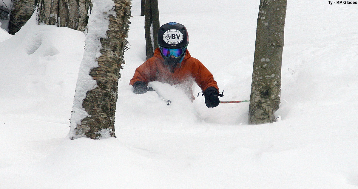
“During today’s session, Steve brought us into Sunrise Glades, Birch Glades, and Lower Gulch Glades, and they were all in
pretty good shape.”
With all the new snow, Steve’s plan for the day was to let us ski a lot. Instead of working on drills, he wanted to work on group management (i.e., how do the coaches effectively manage their groups of students on the slopes) in between the skiing. This was actually a nice change of pace, since E and I have had plenty of sessions with drills for both us and the students over the past few training sessions. One new group management technique that I learned today was for brining the kids into new areas of trees. What Steve likes to do is to show the students the entrance to the glade, but instead of entering that first time, he goes around to the exit of the glade via the trails. That way, the students know what is in store, and are ready with a little more directional orientation for when they actually do ski the glade. We talked a lot about strategies to use when bringing the kids into the trees, and it was a good fit for the trainees in our group, because many worked with the advanced students and were indeed doing a lot of off piste skiing. Steve also worked on the partner strategy for ensuring that everyone is accounted for at each stop. We actually had a real-time demonstration of its effectiveness, since my partner John had misheard our lift destination on one run and ended up at the Gondola instead of the Fourrunner Quad. Since we knew he was missing, I was able to run over to the Gondola and retrieve him.
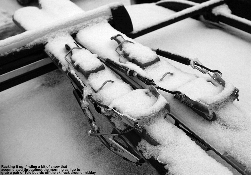
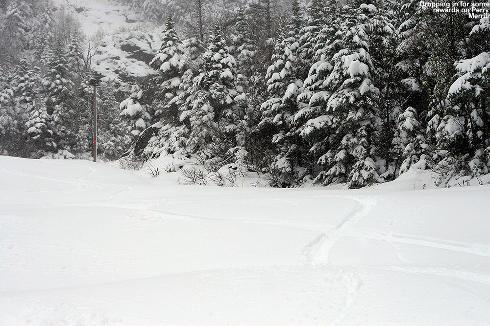
Grabbing the Tele boards for some afternoon turns
In terms of conditions, naturally they were best early on – we had a couple of great runs down Perry Merrill with good packed snow, and chowder and powder off to the edges. It was nice that Steve just let us rip it up. I generally found 12” of powder whenever I looked in undisturbed places, which is presumably the combination of snow from this storm and that frontal passage the other day. The snow depth at the Mt. Mansfield Stake isn’t quite to that 24” mark yet (22” as of this evening’s report), but people are definitely starting to ski those appropriate areas of early season trees. During today’s session, Steve brought us into Sunrise Glades, Birch Glades, and Lower Gulch Glades, and they were all in pretty good shape. If you were going for lines of fresh powder, you wanted to be on your guard a bit since there are still some obstacles about, but in many spots it was hard to tell that it was so early in the season. In areas that had seen skier traffic and had packed snow, you could just ski it and really didn’t have to worry about coverage issues. In any event, it was definitely nice to be back in the trees. Indeed those runs listed are the more moderately pitched, well maintained glades that are amenable to these earlier visits, but they’re very low on the mountain and that says a lot about the current state of the snowpack.
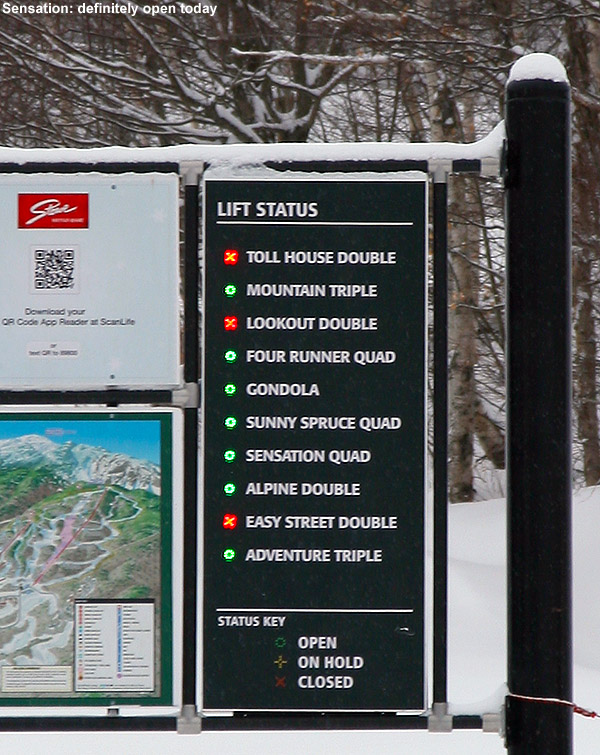
After some lunch and paperwork at the Great Room Grill, Steve said that we were done, but that anyone who wanted to could meet with him at 1:00 P.M. and work on identifying weaknesses in student’s ski technique and how to remedy the situation. Having done a lot of that over the past few sessions, I decided I’d just grab a pair of my Tele skis from the car and take a final run or two before heading home. I was just going to grab my mid fats and head back over toward the Chapel Glades, but then wondered if the Sensation Quad was open – if it wasn’t, it might be a nice place to earn some turns. With that in mind, I grabbed the fat boards off the rack, finding everything covered in a layer of new snow that had fallen during the morning. Once I checked in at the lift status board at the Spruce Peak Base, I saw that indeed the Sensation Quad was running. That meant that the terrain over there on Spruce would likely be pretty packed out, but I decided to just go for it instead of making yet another trip back to the car.
I took a trip up the Sunny Spruce Quad and made my way over toward the base of Sensation. There were actually very few people over in that area, but in terms of traffic, the damage had been done earlier in the day. There were still pockets of powder off to the sides of trials, but with Main Street closed for snowmaking, terrain was limited. Even the hiking terrain above the top of Sensation was tracked up, so people had clearly been doing what they could to get some powder with the limited acreage that’s currently available on Spruce Peak. In spots where the snow surface was down to manmade snow, the fat skis were definitely a poor tool for the job. I ended up just going with alpine turns in the areas where the snow was firm like that, because getting the fat skis on edge in a Telemark stance in those areas felt like trying to get a snowboard on edge on icy terrain. They’re just not meant to do that well. I will say that I notice the deficiencies of fat, rockered skis much less when I ski them alpine, so that may be one reason that so many people are willing to use them as more all around skis (or they just go in with the recent marketing trends and figure that’s the way it is). With my legs cooked from the morning’s runs, I was very ready to call it a day after that trip to the bottom. I really would have liked to venture over to the snowfields above Meadows for some powder, but they had that area roped off because of snowmaking below. It was looking so good in there with the tracks from when it had been skied – hopefully I can get in there on my next Stowe powder day.
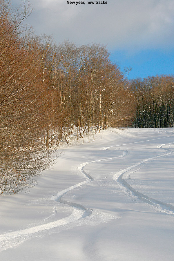
The ski tour we took yesterday was certainly considered a success, since both E and Ty were saying positive things today, and Ty was expressing to Dylan that he missed out on some fun. With the prospects for a little more snow today from a passing Alberta Clipper, I figured another visit to the mountain was in order, and I decided to make it at the end of the day once the new snow had started to accumulate and top off the powder. I couldn’t quite convince anyone else to come with me since they were having too much fun sledding or doing other stuff, so it was another solo outing.
I wasn’t exactly sure when the snow was supposed to start, but eventually it looked like I was going to run out of light, so around 3:00 P.M. I finally headed out. Fortunately, flakes had just started falling in the valley, so I knew the snow would already be well underway up on the hill. Up at Bolton Valley, the temperature in the Village at 2,100’ was 30 F and a steady light snow was coming down. The flakes weren’t huge, but it was accumulating on my equipment quickly enough that gear left out took on a coating within a minute or two.
“Fanny Hill ultimately lost out to Work Road because the snow was just too good – 6 to 8 inches of fluff and hardly a track.”
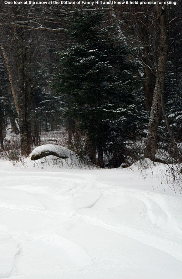
After using Turnpike for the past couple of ascents, and seeing that skier traffic there had been decent, I decided to go for an alternative ascent route up through the Fanny Hill area. It would give me a chance to check out the skiing in that area, and still head over toward the Wilderness Lift Line if I didn’t find anything that seemed to top what we skied yesterday. My first interesting sight was right as I was starting my ascent on Lower Fanny Hill – on one of the small cross trails there was a group of folks hanging out in a protected nook in the trees, just sitting in a circle of chairs and chatting. I suspect they were from the Liftline Condos that were just beyond. There was no wind, so with the light snow falling and temperatures around 30 F, it was indeed a fun time to be outside; it just seemed like a fitting thing to be doing on a dark Sunday afternoon in December.
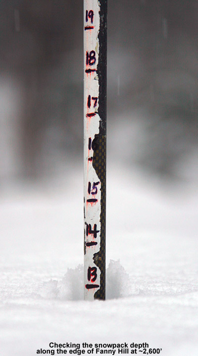
Upon reaching Fanny Hill, the snow looked good, so I decided to continue my ascent there and explore the surfaces further. In general there were the same several inches of powder above the base snow that we’d encountered on the Wilderness Lift Lineyesterday, and only when I got into the steeper sections of terrain near the top did the pitch seem to be too much for the snowpack. In a nice undisturbed spot along the edge of the trail at 2,600’, I was able to check the full snowpack at that elevation, and that came in at 13”. I’d say that consisted of a 6” base, and the rest was powder on top
I continued up toward Upper Fanny Hill, generally staying away from the Sherman’s Pass area where I could hear the snow guns running. Those higher trails like Coyote, Work Road, Lower Crossover, and Swing, held deeper snow and had seen much less traffic. They were definitely going to be on my descent route. I stopped my ascent around 2,900’ on Upper Fanny Hill just before the steepest pitches, because I could see that they were somewhat windswept and just didn’t have the coverage they needed yet.
I played it by ear on the descent, just watching for those trails with deep snow that had seen minimal traffic. Fanny Hill ultimately lost out to Work Road because the snow was just too good – 6 to 8 inches of fluff and hardly a track. That brought me over to the Wilderness Lift Line, and since we’d skied the skier’s right yesterday, I took the skier’s left today and found the same type of good snow. I’m sure Fanny Hill would have been fine as well, but after committing to Work Road I went where gravity took me. The rest of the descent back to the Village was just like yesterday, good soft snow, so no complaints.
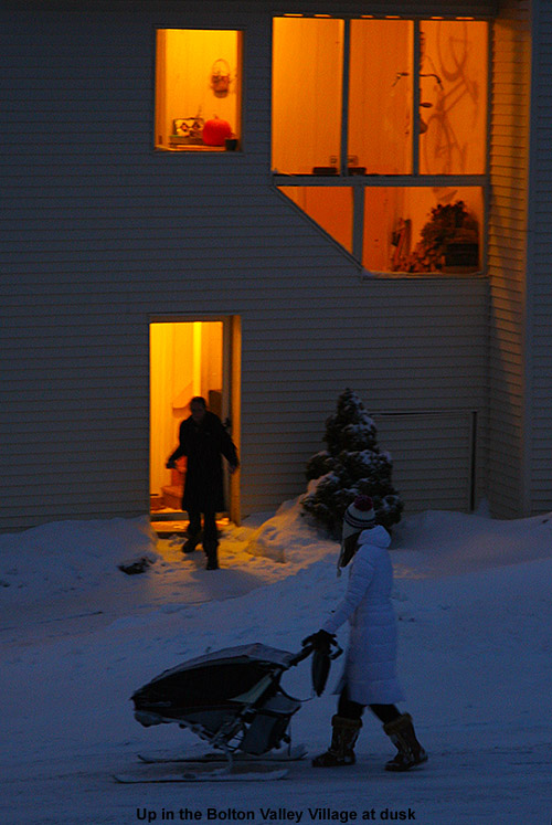
It was getting pretty dark when I was leaving, but the group of folks was still hanging out in their little alcove in the trees – it was a good spot. As I made my way along some of the Liftline Condos, I saw a woman pushing something along through the snow – she made her way through some of the deeper snow around the back of the condos, and then was out of view for a bit before she got onto the street and I could get a picture I didn’t know if it was a stroller, or just some other sort of vehicle for moving things, but whatever the case, the fact that it was on skis was intriguing. Clearly it seemed to be somebody who knows the Bolton Valley environment.
Bolton Valley Village version of getting around
It snowed all the way down to the valley when I was heading back to the house around 5:00 P.M., and the temperatures had fallen below the freezing mark even at the bottom of the access road down at 340’. It looks like the next opportunities for snow are some light stuff in the early week, and then a frontal system later in the week.
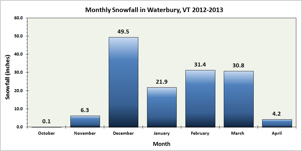
Waterbury snowfall for the 2012-2013 season – broken down by month
The last snowstorm of the 2012-2013 winter season extended all the way out to Memorial Day weekend to produce some great late season skiing, but now that we’re well into summer and all the snow has melted, we can look back at how the winter went down at our location in Vermont’s Winooski Valley. The main focus in the seasonal analysis below is on snowfall, but snowpack and temperatures will be discussed as well. In this post I’ve hit on some of the highlights that came out of the data, and attached our various plots and graphs, but to get to the full data set, you can use the following link:
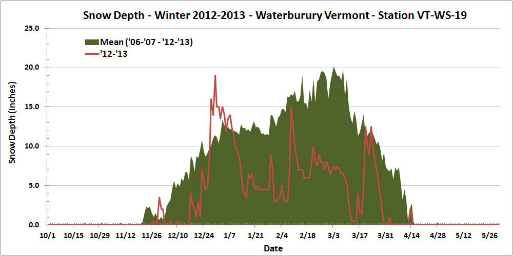
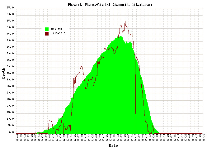
Thankfully, this past season’s snowfall (144.2″) marked a notable increase over the previous season (115.3″), but the total snowfall for 2012-2013 was still less than 90% of average, so that’s not likely to lift the season into the category of “great” winters. In addition, the amount of snow on the ground at the house last season didn’t help to improve the winter’s standing. Using the value of snow depth days as an integrative way of representing the season’s snowpack, one finds the 2012-2013 winter season producing a value of 729 inch-days, less than half the average value, and right down there in the basement with the well below average 2011-2012 season (688 inch-days). And, if the overall snowpack depth hadn’t already undermined any chances of redemption to an average level, the 2012-2013 snowpack secured the season’s ignominy by reaching the lowest value we’ve seen in January and February (3.0″), and coming within a hair’s breadth of melting out in the area around our measurement stake at a record early date in mid March:
This past season’s rather meager snowpack at our location in Waterbury (red line) relative to average (green shading)
Often, each month of the winter/snowfall season has its own unique flavor with respect to the weather, so one method I like to use to get a feel for the winter is to look at it on a month-by-month basis. Again, the focus below is on snowfall at our location, but snowpack is also considered, as well as mountain snowfall/snowpack and the associated effect on the local skiing. I’ll have a separate 2012-2013 ski season summary coming up, so I’ve kept the ski discussion minimal here in anticipation of a more thorough discussion in that report. The month’s total snowfall is listed at the start of each section below for reference:
Snowfall: 0.1″ – October snowfall isn’t reliable enough down at our elevation to be factored much into the seasonal assessment, but this October was on the weak side, with just a tenth of an inch of snow, vs. the mean of roughly an inch. Regardless of this, there was still enough for the needs of companies like https://divisionkangaroof.com/areas-served/gainesville/ with the weight of the snow causing damage to some roofs. One small feather in the cap of 2012-2013 is the fact that the first accumulating snow fell on October 12th, which beats out 2010-2011’s October 15th snowfall by three days, and now represents the earliest measurable snowfall I’ve recorded here at the house since I started monitoring the weather in 2006.
Snowfall: 6.3″ – November snowfall came in just a bit below average this past season, so certainly not remarkable, but notable in that it was probably about as average a November as we’ve seen. November has typically been feast or famine when it comes to snow. We actually had a total of five snowstorms in November, but a small to moderate storm of 4.4″ at the end of the month contributed the bulk of the monthly total as well as some of the first great skiing of the season in the mountains.
Snowfall: 49.5″ – December held the first lengthy, redeeming snowfall period of 2012-2013. Although the first half of the month was extremely poor on snowfall (just 2.2″ of snow at the house), from the 16th of December onward, temperatures got cold and snow came in for a dramatic change; close to 50″ of snow fell on us in the second half of the month, and as a whole the month actually wound up several inches above average. Those in homes with faulty or no heating in place are likely to struggle with the crushing cold at this time of year which is why it’s so important to conduct regular maintenance on heaters so you’re not left to suffer over winter. Reaching out to the likes of these professionals could help with this – siriuspac.com/heating-repair-service/. A problem left unaddressed could snowball into substantial damage and become more costly to repair over time so it’s well worth acting on it as early as possible. We received our second (15.5″) and fourth (11.7″) largest storms of the season during that stretch, right near Christmas and just a few days apart, so needless to say, the snow was there to set quite the holiday mood in the valleys and up above on the slopes.
Snowfall: 21.9″ – January continued that good, snowy weather pattern in its first week, albeit to a lesser degree than December, but unfortunately that modest first week ultimately wound up representing roughly half of the month’s snowfall. The second week featured a couple of substantial thaws with no measurable snow, and in fact we received no accumulating snow at all for the period between January 7th and 16th, a very long stretch for the mountainous areas of Northern Vermont during the winter. The third week of January offered just a few small systems, and the fourth week was arctic cold with minimal snow. The final week attempted to recoup the losses with a modest half foot storm, but it was too little too late – the month ended with just 21.9″ of snow, by far the lowest January in my records. The combination of very low snowfall and two January thaws was very deleterious to the valley snowpack – after coming down from the depths achieved in December, the snowpack depth at our location never even reached 10 inches again during the month, and got as low as 3.0 inches. That is ridiculously close to losing the winter snowpack in January, definitely the closest we’ve come based on my records since 2006.
Snowfall: 31.4″ – February was again below average in snowfall, partly due to the continuation of the dry arctic pattern in the first week, and it wound up missing the mark for the lowest February in my data set by less than an inch. Although that persistent dry pattern didn’t make for a very snowy first half of the month, our third largest storm of the season (12.6″) hit in the second week. It was still a rather modest storm, but at least it did break that one foot mark for accumulation at the house. By the end of the third week of February, the snow depth at the Mt. Mansfield stake actually poked above average for the first time in about a month and a half – but it was only by a couple of inches, and it quickly went back below average as the snowpack sat there essentially stagnant for an entire month. On February 21st, the snowpack was at 65″, and roughly a month later on March 18th, it was still at 65″, without any major consolidation of more than a few inches. That’s stagnant. Our snowpack at the house languished similarly, never even getting above 10 inches of depth during that stretch – and that’s a time of year when it is usually building to its peak of the season. The carryover of the low snowpack from January also set the lowest mark (3.0″) for snowpack that we’ve ever seen in February.
Snowfall: 4.2″ – April was even a couple inches below average for snowfall, but temperatures stayed cool enough to keep the winter season rolling along, and that’s what really helped make the period wintrier. We didn’t have any notable April snow accumulations down at our elevation, just a couple of small ones on the 2nd, and again on the 12th – 13th, but the mountains continued to get fresh snow right into mid month to keep surfaces in great form and the Mt. Mansfield snowpack robust.
Snowfall: 0.0″ – There was no accumulating May snowfall down at the house this season, but that’s not too much of knock on the Month, because not getting snow in May is more the norm than actually getting snow. The mountains did get that beautiful Memorial Day weekend storm though, and the late season powder skiing was mighty fine. Although I can’t factor that directly into the analysis for the valley, it was quite cold in the valleys at the end of the month, and close to even snowing there.
There were a couple of other interesting notes with respect to snowfall this season:
1) Storm frequency and average storm size: Despite coming in below average for snowfall, the 2012-2013 season offered up a healthy 51 accumulating snowstorms, almost up there with the 53 storms we received in 2007-2008. Of course, to come in below average for snowfall with that many storms indicates that the average snowfall per storm was down, and indeed it was. At 2.8″/storm, 2012-2013 ranks down there with 2011-2012 (2.6″/storm), the only odd seasons out compared to the more typical seasons up near 4″/storm. For whatever reason, this season’s average came in on the low side. This is presumably due in part to many of the everyday events being on the small side, but also due to the lack of bigger storms, which is covered in point #2 below.
2) Storms with double-digit snowfall: It’s certainly an arbitrary and subtle distinction, but after looking through my data, I noticed an interesting trend with respect to each season’s largest storms for our location. In my season summaries, I always make a list of the top five storms of the season, and when the season seems to have gone well, all of those top five storms have been in the double digits for snowfall. In fact, the “best” seasons thus far have been able to surpass that five-storm threshold. For reference, here’s the top five list for this season, with the links to the detailed web pages for each storm:
Indeed, if we look at the number of storms with double-digit snowfall by the seasons, we see an obvious trend. With the number of double-digit snowfall storms listed in parentheses after the season, one notes those “good” seasons – 2007-2008 (6), 2008-2009 (7), 2010-2011 (7) seemed to find a way to exceed five double-digit storms, whereas the poorer snowfall seasons – 2006-2007 (4), 2009-2010 (2), 2011-2012 (3), 2012-2013 (4) just didn’t. Surely the law of averages comes into play here to some degree – seasons with patterns producing lots of snow likely have a greater chance of getting a big storm in here, but that’s not a given. It’s also very suspicious that those seasons that come in sort of in that middling ground like 2006-2007 and our season of interest for this summary, 2012-2013, fall just short of making the cut. I suspect this trend may be more intact in a location like ours because of the relatively high number of storms and snowfall, and upslope snow (which was on the low side this season) as an extra protection against huge snowfall variance, but this is going to be an interesting trend to follow into the future as a gauge of snowfall seasons.
In sum, while snowfall was certainly a bit below average, and snowpack was well below average, I’d still give the season a reasonable grade. If C is average, I’d go with a C- for 2012-2013, just a bit off from making the average. Were snowpack a more significant factor in my winter preferences, one could argue for going a bit lower, but at least minimal snowpack was maintained throughout the entirety of the winter to keep everything white. Overall it could have been a lot worse, and with the amount of snowfall we did get, it’s hard to drop the season into the D range, which, based solely on snowfall and snowpack at the house, is where I’d put a season like 2011-2012.
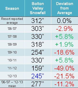
Snowfall: Compared to the snowfall-deficient 2011-2012 Ski Season, the 2012-2013 Ski Season was certainly a step up, but it was still generally below average for snowfall in the mountains of Northern Vermont. It was Bolton Valley that seemed to fare the worst of the northern resorts along the spine of the Green Mountains, perhaps due to their west slope location and this season’s dearth of upslope snow; they reported just 78.5% of their average snowfall. Heading northward, Stowe and Smugg’s fared a bit better at around 85% of average, and Jay Peak reported roughly average snowfall. Down at our house in the Winooski Valley, snowfall was 88.6% of average, so not too shabby by most accounts, but a bit below the mean like some of the local mountains. These past two seasons have actually been the first pair delivering back-to-back below average snowfall in our area since we started keeping track in 2006. Those numbers can be seen in both our Waterbury Winter Weather Summary Table, and the table of Bolton Valley annual snowfall below; this past season’s snowfall is highlighted in blue:
Low snowfall last winter meant back to back seasons with below average snowfall at Bolton Valley.
Snowpack: Aside from the spikes associated with a couple of early season storms, the mountain snowpack was below average going into mid December. That changed quickly though, with the onset of all that new snow during the second half of the month. The above average snowpack achieved during the holidays didn’t actually stay that way during January’s warmth and lack of storms. After consolidation, the snowpack generally trundled along at or below average through February’s continuation of relatively low snowfall. From mid February to mid March, the snowpack sat there essentially stagnant for an entire month; to wit, on February 21st, the snowpack was at 65”, and roughly a month later on March 18th, it was still at 65”, without any notable consolidation of more than a few inches. The late season stretch from mid March to mid April represented a nice rebound for the mountains however, with some quick gains from the big Northern New England March storm getting it above average, and the snow depth staying at least modestly above during the period.
Two periods stood out this past season for above average snowfall: The holiday period and mid-March through the end of April.
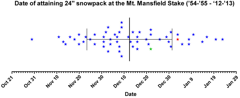
Tree Skiing: One metric used as a rough guide for the start of off piste skiing in the Northern Green Mountains is the point at which the snow depth reaches 24” at the Mt. Mansfield stake. For those unfamiliar with how this metric was established, it’s described in some detail in the 2011-2012 ski season summary. With the incorporation of this season’s data, the mean date remains at December 12th ± 19 days, with an average depth at the stake of 25.9 ± 2.7 inches. After the very slow start in 2011-2012, in which the 24” depth wasn’t attained until January 3rd (more than a standard deviation later than the mean), this past season was notably earlier. The plot below shows the date at which 24” was obtained for each season since 1954, with 2011-2012 shown in red, and 2012-2013 shown in green:
Each star marks the date of attaining a snow depth of 24 inches at the Mt. Mansfield stake, covering all years since 1954. Although still a bit later than average, reaching a depth of 24 inches at the stake this past season (green star – Dec 22) occurred much earlier than the previous season (red star – Jan 3). The mean date for attaining a depth of 24″ is marked by the large vertical bar in the center of the plot, and the smaller bars indicate the range of one standard deviation above and below that mean.
This past season, the date (December 22nd, Depth=28”, Green Star) was still later than average due in part to the slow first half of December, but unlike last season it was well within the 1 S.D. bars (thin vertical black lines). Note that the 24” mark is being used as an indicator of when the first forays into appropriate off piste/tree skiing terrain typically start in the Central and Northern Greens. In terms of empirical tree skiing observations, personal experience again lends some support to the use of 24” mark this season, as we began venturing into the trees the very next day on December 23rd at Bolton Valley. It should be noted though, that while the 24” mark was attained on December 22nd this season, the 40” mark was attained the very next day on December 23rd. The 40-inch rule (i.e. reaching a depth of 40” at the stake), is used as an indicator of when most off piste/tree skiing around here is ready to go. Although I haven’t looked into the data, this season has got to represent one of the quickest ascents from 24” to 40” – it’s interesting to note however that after rising to 42” of depth on December 23rd and 24th, the snowpack settled back to 36” for a couple of days before rebounding to 45” on the 27th.
Snow Quality: As an monitor of snow quality for the season, the chronological list of our ski outings has once again been compiled, with those days in which we were skiing powder indicated by a P, and those days in which powder skiing wasn’t available indicated by an X. The availability of powder suggests a fairly high level of snow quality, and the absence of powder generally indicates that temperatures rose above freezing at all elevations. Each listing below represents a link to the full report where images and more information from the outing can be obtained. Outings with an X may still be providing decent skiing such as wet snow, corn, etc. (or else skiing was typically avoided) but aside from the spring period, there’s going to be a price to pay in terms of snow quality associated with these episodes when temperatures eventually cool back down. The pattern of snow conditions in the Northern Green Mountains was fairly typical this past winter, with those days lacking powder skiing showing up in three distinct periods: 1) the early season with its usual temperature fluctuations, up through mid December before the weather pattern changed and the cold weather stabilized, 2) a thaw period in mid January, and 3) the period starting in mid March where spring weather began to make inroads. However, with the way the weather patterns this past spring continued to provide cool temperatures and snowfall, powder skiing generally dominated until mid April. Having analyzed the skiing in this way for the past three seasons, a surprising level of consistency is noted, with an overall average of close to four out of five days providing powder, despite notable differences in the demeanor of these recent ski seasons. The 2010-2011 season, which was above average in snowfall, provided powder on 78% of outings, the 2011-2012 season, which was well below average in many ways, revealed the same 78%, and most recently the 2012-2013 season, which was slightly below average in this area, produced a very similar 77% of outings with powder. The percentages don’t take into account differences in the number of outings each season, but with all three seasons falling into the range of 50 to 60 ski outings, differences in the sample sizes aren’t huge. The list of categorized ski outings with links to their full reports follows below:
The detailed month-by-month synopsis of the season is next:
October: It wasn’t an especially snowy October to kick off the season; we had five rounds of snow in the mountains, and the third one even dropped accumulations to the lowest mountain valleys, but none of the storms were huge dumps, and we had just a tenth of an inch of snowfall down at the house for the month. October’s first snowstorm started up on the 7th, with snowfall being reported at the top of the Mt. Mansfield Toll Road in the afternoon, and by the next morning Powderfreak sent along his picture of 4” of accumulation at the top of the Stowe Gondola. I also got a shot of Mt. Mansfield later in the day with its first accumulation of the season. It didn’t seem like quite enough snow to tempt me out to ski, but the FIS boys hit the snow and provided a thorough report of the turns. The second storm delivered some accumulation on the 11th, with a snow line up around the 3,000’ level and less than an inch of snow found up on Mt. Mansfield. The third storm was the one that finally touched the lower valleys with some minimal accumulations, but in terms of mountain accumulations, I don’t think it was anything more than junkboarding material. The 4th (on the 14th of the month) and 5th (on the 16th of the month) storms of October also appeared to be pretty minimal and generally flew under the radar in terms of discussion. So while it wasn’t a great October for natural snow skiing (with nothing like the back-to-back larger storms at the end of October during the previous season), some folks made some turns and there were several smaller rounds of snow to keep the peaks white.
April: Despite the somewhat slow increases in the snowpack during the heart of the winter, the gains made during the latter half of March meant that the snowpack was at least modestly above average heading into April, and it quickly reached a peak of 87 inches at the Mt. Mansfield Stake when the first storm of the month dropped a foot of snow at Stowe on April 2nd. I was up at Bolton Valley that day for a ski tour, and I got to witness some impressive snowfall rates as the storm crashed into the higher elevations. The alpine terrain above tree line on Mt. Mansfield was in good shape, consistently providing excellent outings during that first part of the month. Cool temperatures with additional snow meant that the snowpack stayed at an above average level right through the month, and another storm on the 12th saw Ty and I enjoying close to a foot of dense powder out in the Bypass Chutes at Stowe on the 13th. The skiing gradually transitioned to full on spring conditions after that weekend as the active pattern waned, and an impressively long stretch of clear weather moved in and stuck around well into May.
May: For most of May, there wasn’t much to talk about in terms of new powder, especially with the extended period of incredibly clear weather that carried over from the end of April and lasted a fortnight, finally ending on the 10th of the month. There was some mighty fine spring skiing right through that period with all the sun and warm weather, even if it did cause the snowpack to decrease a bit faster than it otherwise might have. The tranquil period of warm weather allowed the Mt. Washington Auto Road to open on the 10th of the month as well (definitely on the early side), but since unsettled weather had just returned at that point, we didn’t get to make our spring pilgrimage to the snowfields until the 18th. To really cap the month off well, Northern New England and the Adirondacks were rewarded with a Nor’easter over Memorial Day Weekend, which delivered roughly 3 feet of powder to Whiteface and nearly 2 feet to Mt. Mansfield. Excellent powder turns were made while the valleys were almost fully leafed out for the spring. We didn’t actually head out for any June turns beyond that, but the skiing over Memorial Day Weekend had been so good that it hardly mattered – it was just a few short months until the snows of fall would be returning.
So what about the overall feel for the quality of the ski season in Northern Vermont? Well, much like the snowfall numbers suggest, it feels like it came in a bit below average, even if not horribly so. The mountain snowpack (as gauged by what was seen at the stake on Mt. Mansfield) had its ups and downs, and on balance it probably gets rated in a similar manner to what the slightly subpar snowfall would suggest. Being frequent Bolton Valley skiers and living down below the mountain in the Winooski Valley, our perspective might be skewed a bit downward with the resort receiving just 78.5% of their average snowfall. Having the north miss out somewhat on a couple of big regional storms, while watching a horrid valley snowpack (see the 2012-2013 Winter Weather Summary for details) that kept ski routes to the lower valley bottoms essentially off the table, certainly didn’t win the season any extra points. It seems that 2012-2013 ultimately sits in the lower half of ski seasons and won’t be remembered as anything epic, but it also appeared to hold onto a decent level of powder availability (77%) based on our experiences, and that means there was still a pretty decent amount of good skiing. The fact that even the poor 2011-2012 Ski Season was able to hold onto a powder percentage in that range is also reassuring in that regard, suggesting that there is indeed a certainly level of reliability that can be expected in these seasons where snowfall/snowpack is below average.
We’re pleased to announce the completion of our Bolton Valley Photo Gallery for the 2012-2013 ski season. This year’s gallery is our largest to date, with over 270 images documenting this season’s ski adventures indoors and out, in the front, side, and backcountry, under blue skies and flake-dumping maelstroms at Vermont’sBolton Valley Ski Resort. Continue on to the thumbnail images below and browse away! Detailed reports are associated with every photograph in the gallery, so if you find a scene that sparks your interest, simply hover over the thumbnail image to get the date, and head to the archives on the right side of the page to read the full report. We’ve also got similarly extensive galleries from the past several ski seasons, representing nearly 1,600 photographs from around Bolton Valley, and these can all be found at our J&E Productions Photo Galleries Page. We’ll also have our full 2012-2013 Ski Season Summary coming out later this summer, so stay tuned for that update as well.

 Now that we’re back into a more consistently wintry weather regime, the Northern Greens snow globe has kicked in, and we’ve had a fairly consistent supply of light fluffy snows in the air. It’s not really substantiating the base snow, but it is creating quite the quintessential Vermont winter scene for holiday visitors, and it’s topping off the slopes with some serious softness. Another burst of flakes was just kicking off when we left the house to head up to the mountain today after lunch, and the snowfall intensity increased as we headed up toward the resort. Up in the Village we encountered temperatures in the low 20s F and steady light but accumulating snows. There were plenty of cars in the parking lots, but since spots were opening up with early afternoon departures, we secured a spot right at the north end of the upper lot.
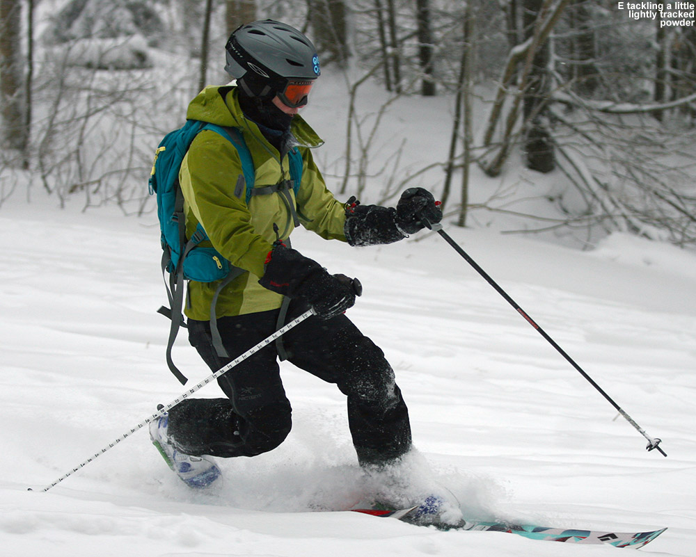 The descent was a peaceful glide through silky smooth powder, with only the occasional touchdown on the old base. The pitch and powder were essentially perfect, although the powder was deep enough that Dylan would sometimes have difficulty keeping his speed up. Dylan’s Telemark skis (Völkl Gotama Juniors) are fairly wide, but nothing like the Black Diamond Elements and AMPerages that E and I were using, and momentum issues aside, you could really feel the way the floatation afforded by our fat skis was letting us ride a bit higher and faster in the powder on those lower-angle pitches. I was curious to see if E had noticed the effect, so I asked her how she felt about the speed of her skis on the descent. She initially thought that they were very fast, and figured it was because they haven’t been used for too many outings and had been waxed. I explained that a good part of that was actually from the floatation that the skis provided. Ty invented a new descent technique where he would kneel all the way on the tips of his skis with both knees, and in the powder it gave the illusion that he was just kneeling in the snow with no skis and flying down the mountain. We’ll have to get some video of that at some point, because it’s quite a hoot.
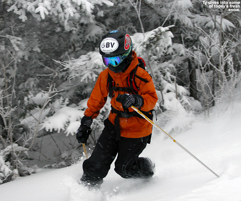


")

