Waterbury snowfall for the 2012-2013 season – broken down by month
The last snowstorm of the 2012-2013 winter season extended all the way out to Memorial Day weekend to produce some great late season skiing, but now that we’re well into summer and all the snow has melted, we can look back at how the winter went down at our location in Vermont’s Winooski Valley. The main focus in the seasonal analysis below is on snowfall, but snowpack and temperatures will be discussed as well. In this post I’ve hit on some of the highlights that came out of the data, and attached our various plots and graphs, but to get to the full data set, you can use the following link:
Thankfully, this past season’s snowfall (144.2″) marked a notable increase over the previous season (115.3″), but the total snowfall for 2012-2013 was still less than 90% of average, so that’s not likely to lift the season into the category of “great” winters. In addition, the amount of snow on the ground at the house last season didn’t help to improve the winter’s standing. Using the value of snow depth days as an integrative way of representing the season’s snowpack, one finds the 2012-2013 winter season producing a value of 729 inch-days, less than half the average value, and right down there in the basement with the well below average 2011-2012 season (688 inch-days). And, if the overall snowpack depth hadn’t already undermined any chances of redemption to an average level, the 2012-2013 snowpack secured the season’s ignominy by reaching the lowest value we’ve seen in January and February (3.0″), and coming within a hair’s breadth of melting out in the area around our measurement stake at a record early date in mid March:
This past season’s rather meager snowpack at our location in Waterbury (red line) relative to average (green shading)
Often, each month of the winter/snowfall season has its own unique flavor with respect to the weather, so one method I like to use to get a feel for the winter is to look at it on a month-by-month basis. Again, the focus below is on snowfall at our location, but snowpack is also considered, as well as mountain snowfall/snowpack and the associated effect on the local skiing. I’ll have a separate 2012-2013 ski season summary coming up, so I’ve kept the ski discussion minimal here in anticipation of a more thorough discussion in that report. The month’s total snowfall is listed at the start of each section below for reference:
Snowfall: 0.1″ – October snowfall isn’t reliable enough down at our elevation to be factored much into the seasonal assessment, but this October was on the weak side, with just a tenth of an inch of snow, vs. the mean of roughly an inch. Regardless of this, there was still enough for the needs of companies like https://divisionkangaroof.com/areas-served/gainesville/ with the weight of the snow causing damage to some roofs. One small feather in the cap of 2012-2013 is the fact that the first accumulating snow fell on October 12th, which beats out 2010-2011’s October 15th snowfall by three days, and now represents the earliest measurable snowfall I’ve recorded here at the house since I started monitoring the weather in 2006.
Snowfall: 6.3″ – November snowfall came in just a bit below average this past season, so certainly not remarkable, but notable in that it was probably about as average a November as we’ve seen. November has typically been feast or famine when it comes to snow. We actually had a total of five snowstorms in November, but a small to moderate storm of 4.4″ at the end of the month contributed the bulk of the monthly total as well as some of the first great skiing of the season in the mountains.
Snowfall: 49.5″ – December held the first lengthy, redeeming snowfall period of 2012-2013. Although the first half of the month was extremely poor on snowfall (just 2.2″ of snow at the house), from the 16th of December onward, temperatures got cold and snow came in for a dramatic change; close to 50″ of snow fell on us in the second half of the month, and as a whole the month actually wound up several inches above average. Those in homes with faulty or no heating in place are likely to struggle with the crushing cold at this time of year which is why it’s so important to conduct regular maintenance on heaters so you’re not left to suffer over winter. Reaching out to the likes of these professionals could help with this – siriuspac.com/heating-repair-service/. A problem left unaddressed could snowball into substantial damage and become more costly to repair over time so it’s well worth acting on it as early as possible. We received our second (15.5″) and fourth (11.7″) largest storms of the season during that stretch, right near Christmas and just a few days apart, so needless to say, the snow was there to set quite the holiday mood in the valleys and up above on the slopes.
Snowfall: 21.9″ – January continued that good, snowy weather pattern in its first week, albeit to a lesser degree than December, but unfortunately that modest first week ultimately wound up representing roughly half of the month’s snowfall. The second week featured a couple of substantial thaws with no measurable snow, and in fact we received no accumulating snow at all for the period between January 7th and 16th, a very long stretch for the mountainous areas of Northern Vermont during the winter. The third week of January offered just a few small systems, and the fourth week was arctic cold with minimal snow. The final week attempted to recoup the losses with a modest half foot storm, but it was too little too late – the month ended with just 21.9″ of snow, by far the lowest January in my records. The combination of very low snowfall and two January thaws was very deleterious to the valley snowpack – after coming down from the depths achieved in December, the snowpack depth at our location never even reached 10 inches again during the month, and got as low as 3.0 inches. That is ridiculously close to losing the winter snowpack in January, definitely the closest we’ve come based on my records since 2006.
Snowfall: 31.4″ – February was again below average in snowfall, partly due to the continuation of the dry arctic pattern in the first week, and it wound up missing the mark for the lowest February in my data set by less than an inch. Although that persistent dry pattern didn’t make for a very snowy first half of the month, our third largest storm of the season (12.6″) hit in the second week. It was still a rather modest storm, but at least it did break that one foot mark for accumulation at the house. By the end of the third week of February, the snow depth at the Mt. Mansfield stake actually poked above average for the first time in about a month and a half – but it was only by a couple of inches, and it quickly went back below average as the snowpack sat there essentially stagnant for an entire month. On February 21st, the snowpack was at 65″, and roughly a month later on March 18th, it was still at 65″, without any major consolidation of more than a few inches. That’s stagnant. Our snowpack at the house languished similarly, never even getting above 10 inches of depth during that stretch – and that’s a time of year when it is usually building to its peak of the season. The carryover of the low snowpack from January also set the lowest mark (3.0″) for snowpack that we’ve ever seen in February.
Snowfall: 4.2″ – April was even a couple inches below average for snowfall, but temperatures stayed cool enough to keep the winter season rolling along, and that’s what really helped make the period wintrier. We didn’t have any notable April snow accumulations down at our elevation, just a couple of small ones on the 2nd, and again on the 12th – 13th, but the mountains continued to get fresh snow right into mid month to keep surfaces in great form and the Mt. Mansfield snowpack robust.
Snowfall: 0.0″ – There was no accumulating May snowfall down at the house this season, but that’s not too much of knock on the Month, because not getting snow in May is more the norm than actually getting snow. The mountains did get that beautiful Memorial Day weekend storm though, and the late season powder skiing was mighty fine. Although I can’t factor that directly into the analysis for the valley, it was quite cold in the valleys at the end of the month, and close to even snowing there.
There were a couple of other interesting notes with respect to snowfall this season:
1) Storm frequency and average storm size: Despite coming in below average for snowfall, the 2012-2013 season offered up a healthy 51 accumulating snowstorms, almost up there with the 53 storms we received in 2007-2008. Of course, to come in below average for snowfall with that many storms indicates that the average snowfall per storm was down, and indeed it was. At 2.8″/storm, 2012-2013 ranks down there with 2011-2012 (2.6″/storm), the only odd seasons out compared to the more typical seasons up near 4″/storm. For whatever reason, this season’s average came in on the low side. This is presumably due in part to many of the everyday events being on the small side, but also due to the lack of bigger storms, which is covered in point #2 below.
2) Storms with double-digit snowfall: It’s certainly an arbitrary and subtle distinction, but after looking through my data, I noticed an interesting trend with respect to each season’s largest storms for our location. In my season summaries, I always make a list of the top five storms of the season, and when the season seems to have gone well, all of those top five storms have been in the double digits for snowfall. In fact, the “best” seasons thus far have been able to surpass that five-storm threshold. For reference, here’s the top five list for this season, with the links to the detailed web pages for each storm:
Indeed, if we look at the number of storms with double-digit snowfall by the seasons, we see an obvious trend. With the number of double-digit snowfall storms listed in parentheses after the season, one notes those “good” seasons – 2007-2008 (6), 2008-2009 (7), 2010-2011 (7) seemed to find a way to exceed five double-digit storms, whereas the poorer snowfall seasons – 2006-2007 (4), 2009-2010 (2), 2011-2012 (3), 2012-2013 (4) just didn’t. Surely the law of averages comes into play here to some degree – seasons with patterns producing lots of snow likely have a greater chance of getting a big storm in here, but that’s not a given. It’s also very suspicious that those seasons that come in sort of in that middling ground like 2006-2007 and our season of interest for this summary, 2012-2013, fall just short of making the cut. I suspect this trend may be more intact in a location like ours because of the relatively high number of storms and snowfall, and upslope snow (which was on the low side this season) as an extra protection against huge snowfall variance, but this is going to be an interesting trend to follow into the future as a gauge of snowfall seasons.
In sum, while snowfall was certainly a bit below average, and snowpack was well below average, I’d still give the season a reasonable grade. If C is average, I’d go with a C- for 2012-2013, just a bit off from making the average. Were snowpack a more significant factor in my winter preferences, one could argue for going a bit lower, but at least minimal snowpack was maintained throughout the entirety of the winter to keep everything white. Overall it could have been a lot worse, and with the amount of snowfall we did get, it’s hard to drop the season into the D range, which, based solely on snowfall and snowpack at the house, is where I’d put a season like 2011-2012.
Snowfall: Compared to the snowfall-deficient 2011-2012 Ski Season, the 2012-2013 Ski Season was certainly a step up, but it was still generally below average for snowfall in the mountains of Northern Vermont. It was Bolton Valley that seemed to fare the worst of the northern resorts along the spine of the Green Mountains, perhaps due to their west slope location and this season’s dearth of upslope snow; they reported just 78.5% of their average snowfall. Heading northward, Stowe and Smugg’s fared a bit better at around 85% of average, and Jay Peak reported roughly average snowfall. Down at our house in the Winooski Valley, snowfall was 88.6% of average, so not too shabby by most accounts, but a bit below the mean like some of the local mountains. These past two seasons have actually been the first pair delivering back-to-back below average snowfall in our area since we started keeping track in 2006. Those numbers can be seen in both our Waterbury Winter Weather Summary Table, and the table of Bolton Valley annual snowfall below; this past season’s snowfall is highlighted in blue:
Low snowfall last winter meant back to back seasons with below average snowfall at Bolton Valley.
Snowpack: Aside from the spikes associated with a couple of early season storms, the mountain snowpack was below average going into mid December. That changed quickly though, with the onset of all that new snow during the second half of the month. The above average snowpack achieved during the holidays didn’t actually stay that way during January’s warmth and lack of storms. After consolidation, the snowpack generally trundled along at or below average through February’s continuation of relatively low snowfall. From mid February to mid March, the snowpack sat there essentially stagnant for an entire month; to wit, on February 21st, the snowpack was at 65”, and roughly a month later on March 18th, it was still at 65”, without any notable consolidation of more than a few inches. The late season stretch from mid March to mid April represented a nice rebound for the mountains however, with some quick gains from the big Northern New England March storm getting it above average, and the snow depth staying at least modestly above during the period.
Two periods stood out this past season for above average snowfall: The holiday period and mid-March through the end of April.
Tree Skiing: One metric used as a rough guide for the start of off piste skiing in the Northern Green Mountains is the point at which the snow depth reaches 24” at the Mt. Mansfield stake. For those unfamiliar with how this metric was established, it’s described in some detail in the 2011-2012 ski season summary. With the incorporation of this season’s data, the mean date remains at December 12th ± 19 days, with an average depth at the stake of 25.9 ± 2.7 inches. After the very slow start in 2011-2012, in which the 24” depth wasn’t attained until January 3rd (more than a standard deviation later than the mean), this past season was notably earlier. The plot below shows the date at which 24” was obtained for each season since 1954, with 2011-2012 shown in red, and 2012-2013 shown in green:
Each star marks the date of attaining a snow depth of 24 inches at the Mt. Mansfield stake, covering all years since 1954. Although still a bit later than average, reaching a depth of 24 inches at the stake this past season (green star – Dec 22) occurred much earlier than the previous season (red star – Jan 3). The mean date for attaining a depth of 24″ is marked by the large vertical bar in the center of the plot, and the smaller bars indicate the range of one standard deviation above and below that mean.
This past season, the date (December 22nd, Depth=28”, Green Star) was still later than average due in part to the slow first half of December, but unlike last season it was well within the 1 S.D. bars (thin vertical black lines). Note that the 24” mark is being used as an indicator of when the first forays into appropriate off piste/tree skiing terrain typically start in the Central and Northern Greens. In terms of empirical tree skiing observations, personal experience again lends some support to the use of 24” mark this season, as we began venturing into the trees the very next day on December 23rd at Bolton Valley. It should be noted though, that while the 24” mark was attained on December 22nd this season, the 40” mark was attained the very next day on December 23rd. The 40-inch rule (i.e. reaching a depth of 40” at the stake), is used as an indicator of when most off piste/tree skiing around here is ready to go. Although I haven’t looked into the data, this season has got to represent one of the quickest ascents from 24” to 40” – it’s interesting to note however that after rising to 42” of depth on December 23rd and 24th, the snowpack settled back to 36” for a couple of days before rebounding to 45” on the 27th.
Snow Quality: As an monitor of snow quality for the season, the chronological list of our ski outings has once again been compiled, with those days in which we were skiing powder indicated by a P, and those days in which powder skiing wasn’t available indicated by an X. The availability of powder suggests a fairly high level of snow quality, and the absence of powder generally indicates that temperatures rose above freezing at all elevations. Each listing below represents a link to the full report where images and more information from the outing can be obtained. Outings with an X may still be providing decent skiing such as wet snow, corn, etc. (or else skiing was typically avoided) but aside from the spring period, there’s going to be a price to pay in terms of snow quality associated with these episodes when temperatures eventually cool back down. The pattern of snow conditions in the Northern Green Mountains was fairly typical this past winter, with those days lacking powder skiing showing up in three distinct periods: 1) the early season with its usual temperature fluctuations, up through mid December before the weather pattern changed and the cold weather stabilized, 2) a thaw period in mid January, and 3) the period starting in mid March where spring weather began to make inroads. However, with the way the weather patterns this past spring continued to provide cool temperatures and snowfall, powder skiing generally dominated until mid April. Having analyzed the skiing in this way for the past three seasons, a surprising level of consistency is noted, with an overall average of close to four out of five days providing powder, despite notable differences in the demeanor of these recent ski seasons. The 2010-2011 season, which was above average in snowfall, provided powder on 78% of outings, the 2011-2012 season, which was well below average in many ways, revealed the same 78%, and most recently the 2012-2013 season, which was slightly below average in this area, produced a very similar 77% of outings with powder. The percentages don’t take into account differences in the number of outings each season, but with all three seasons falling into the range of 50 to 60 ski outings, differences in the sample sizes aren’t huge. The list of categorized ski outings with links to their full reports follows below:
The detailed month-by-month synopsis of the season is next:
October: It wasn’t an especially snowy October to kick off the season; we had five rounds of snow in the mountains, and the third one even dropped accumulations to the lowest mountain valleys, but none of the storms were huge dumps, and we had just a tenth of an inch of snowfall down at the house for the month. October’s first snowstorm started up on the 7th, with snowfall being reported at the top of the Mt. Mansfield Toll Road in the afternoon, and by the next morning Powderfreak sent along his picture of 4” of accumulation at the top of the Stowe Gondola. I also got a shot of Mt. Mansfield later in the day with its first accumulation of the season. It didn’t seem like quite enough snow to tempt me out to ski, but the FIS boys hit the snow and provided a thorough report of the turns. The second storm delivered some accumulation on the 11th, with a snow line up around the 3,000’ level and less than an inch of snow found up on Mt. Mansfield. The third storm was the one that finally touched the lower valleys with some minimal accumulations, but in terms of mountain accumulations, I don’t think it was anything more than junkboarding material. The 4th (on the 14th of the month) and 5th (on the 16th of the month) storms of October also appeared to be pretty minimal and generally flew under the radar in terms of discussion. So while it wasn’t a great October for natural snow skiing (with nothing like the back-to-back larger storms at the end of October during the previous season), some folks made some turns and there were several smaller rounds of snow to keep the peaks white.
April: Despite the somewhat slow increases in the snowpack during the heart of the winter, the gains made during the latter half of March meant that the snowpack was at least modestly above average heading into April, and it quickly reached a peak of 87 inches at the Mt. Mansfield Stake when the first storm of the month dropped a foot of snow at Stowe on April 2nd. I was up at Bolton Valley that day for a ski tour, and I got to witness some impressive snowfall rates as the storm crashed into the higher elevations. The alpine terrain above tree line on Mt. Mansfield was in good shape, consistently providing excellent outings during that first part of the month. Cool temperatures with additional snow meant that the snowpack stayed at an above average level right through the month, and another storm on the 12th saw Ty and I enjoying close to a foot of dense powder out in the Bypass Chutes at Stowe on the 13th. The skiing gradually transitioned to full on spring conditions after that weekend as the active pattern waned, and an impressively long stretch of clear weather moved in and stuck around well into May.
May: For most of May, there wasn’t much to talk about in terms of new powder, especially with the extended period of incredibly clear weather that carried over from the end of April and lasted a fortnight, finally ending on the 10th of the month. There was some mighty fine spring skiing right through that period with all the sun and warm weather, even if it did cause the snowpack to decrease a bit faster than it otherwise might have. The tranquil period of warm weather allowed the Mt. Washington Auto Road to open on the 10th of the month as well (definitely on the early side), but since unsettled weather had just returned at that point, we didn’t get to make our spring pilgrimage to the snowfields until the 18th. To really cap the month off well, Northern New England and the Adirondacks were rewarded with a Nor’easter over Memorial Day Weekend, which delivered roughly 3 feet of powder to Whiteface and nearly 2 feet to Mt. Mansfield. Excellent powder turns were made while the valleys were almost fully leafed out for the spring. We didn’t actually head out for any June turns beyond that, but the skiing over Memorial Day Weekend had been so good that it hardly mattered – it was just a few short months until the snows of fall would be returning.
So what about the overall feel for the quality of the ski season in Northern Vermont? Well, much like the snowfall numbers suggest, it feels like it came in a bit below average, even if not horribly so. The mountain snowpack (as gauged by what was seen at the stake on Mt. Mansfield) had its ups and downs, and on balance it probably gets rated in a similar manner to what the slightly subpar snowfall would suggest. Being frequent Bolton Valley skiers and living down below the mountain in the Winooski Valley, our perspective might be skewed a bit downward with the resort receiving just 78.5% of their average snowfall. Having the north miss out somewhat on a couple of big regional storms, while watching a horrid valley snowpack (see the 2012-2013 Winter Weather Summary for details) that kept ski routes to the lower valley bottoms essentially off the table, certainly didn’t win the season any extra points. It seems that 2012-2013 ultimately sits in the lower half of ski seasons and won’t be remembered as anything epic, but it also appeared to hold onto a decent level of powder availability (77%) based on our experiences, and that means there was still a pretty decent amount of good skiing. The fact that even the poor 2011-2012 Ski Season was able to hold onto a powder percentage in that range is also reassuring in that regard, suggesting that there is indeed a certainly level of reliability that can be expected in these seasons where snowfall/snowpack is below average.
With everyone having their own unique perspective on skiing, some of which you can discover at supreme ski morzine skiing school. They tend to love skiing since they teach people how to do it! But combined with the multitude of weather-related factors involved in winter recreation in general, there’s usually ample room for debate about where a ski season sits relative to average. However, when it comes to the 2011-2012 ski season in Northern Vermont (and perhaps to an even greater extent in other parts of the Northeastern U.S.) most any metric would set it firmly in the lower half of seasons. Some key contributing factors to the outcome of the season were temperatures, which were above average for every month from October through May (specific monthly temperature departures are available in the monthly detail section), overall precipitation, which was well below average during that period, and as expected with that combination, snowfall that was well below average. However, the numbers don’t always tell the whole story, and indeed that was the case in Northern Vermont this past season. If numbers aren’t everything, perhaps timing is everything, and the snow machine of the Northern Greens exhibited some impeccable timing for some of the busiest ski periods when it came down to it. There was also a consistency and intensity in backside snows that seemed to heal just about every mixed precipitation event. So while I don’t think that the winter of 2011-2012 can be considered anything but below average around here, the bigger story might just be how “surprisingly good” it was. That story unfolds in the details below, and may inspire people to look at other skiing options. Some may consider the vail village ski rentals in such a situation, especially after reading about this different location.
Snowfall: A very reliable and trustworthy indicator of just how poor the winter’s snowfall was for the general Northern Vermont area, is the data from the area’s first-order weather station at the National Weather Service Office in Burlington. Out of 127 years worth of data going back to the winter of 1884-1885, the 37.7″ of total snowfall in Burlington during 2011-2012 was the third lowest in their records (only 1912-1913 with 31.3″ and 1904-1905 with 32.0″ were lower). Interestingly this third lowest recorded snowfall obtained in 2011-2012 came right on the heels of Burlington’s third highest recorded snowfall of 128.4″ in 2010-2011. Relative to average snowfall, which for the 1884-2011 period of record in Burlington is 73.3″, 2011-2012 came in at just 51.4%. Burlington is the local first-order weather station for the area, but despite its proximity to the spine of the Northern Greens, the Champlain Valley’s snowfall doesn’t necessarily correlate with what goes on in the mountains. Looking next at Winooski Valley snowfall data obtained from our house, which sits right along the spine and is a decent representation of what happens in the mountain valleys of the Greens, we find that snowfall was well below average during all the key winter months, and our season total was 115.3″. Not surprisingly, this is the lowest snowfall total obtained in the six years that we have collected rigorous data at our location, and it’s almost two standard deviations below the mean (172.1 ± 31.5″) obtained from 2006-2011. However, at 67.0% of the average snowfall, it’s not quite as low as what Burlington experienced. Like the local mountains themselves, some spots in the mountain valleys have what Powderfreak refers to as a snowfall “insurance policy”, which comes in the form of upslope snow. Burlington and the Champlain Valley can get in on a bit of mesoscale weather action in the form of lake-effect snow from Lake Champlain, but it’s not a major contributor to snowfall due to the size and orientation of the lake. To the east of the Champlain Valley however, the upslope snow, sometimes referred to as Champlain Powder™, is what sets the snowfall in the Greens apart from areas that rely solely on synoptic precipitation. Interestingly, as we head up in elevation above our house in the valley, we find Bolton Valley reporting a very similar deviation from average snowfall compared to Burlington this season. Bolton recorded 159″ of snow this past season, which based on Bolton’s reported seasonal snowfall mean of 312″, comes in at just 51.0% of average. That amount of snow is extremely low for this area, and is more akin to what one might find in a typical season at Lake Louise Ski Area in Alberta vs. the spine of Vermont’sNorthern Greens. The updated table with Bolton Valley’s snowfall from the past several seasons is added below, which illustrates the strong snowfall deviation from average seen in 2011-2012:
Snowfall at Bolton Valley Resort during the 2011-2012 ski season (shown in blue) was extremely low, just half the average amount.
Although still well below average all around, there certainly was a trend toward slightly better snowfall as one continued to head north in the state, with the northward trend of 63.4% at Stowe, 66.6% at Smuggler’s Notch, and 71.5% at Jay Peak relative to average. A contributor to the low snowfall at the resorts was the fact that there was really only one big, multi-foot storm cycle during the heart of the season. That storm came at the end of February and dropped 40″ at Jay Peak, just on the heels of a couple smaller systems for a total in excess of 50″ of snow in just a few days. The resulting skiing was fantastic due the density gradient that was set up by the way it fell – 1 to 2 feet of dense snow came first, and it was topped off with another couple feet of champagne that finished at around 2% H2O. The snowpack at the Mt. Mansfield Stake jumped from 49″ to 81″ during that period, and the icing on the cake was that the storm cleared right out to produce bluebird skies on Feb 26th. Unfortunately, one great storm doesn’t make a season. Based on estimations from my weather data, on average we should only expect one or two of those 40″+ storms per season, but they would typically be backed up by several 20″+ storms, and the deficiency of those is part of what left the overall snowfall lacking.
Tree Skiing:In the past I’ve used empirical data from trip reports to establish a mean date for the start of tree skiing in Northern/North-Central Vermont, and as I outlined in last year’s ski season summary, that analysis revealed a date of December 10th ± 13 days, with an average depth at the stake of 28.1 ± 6.5 inches. However, after a comment from Powderfreak back on December 12th, in which he indicated that he’d observed tree skiing on appropriate terrain at Stowe to start roughly when the snow depth at the Mt. Mansfield Stake hit 24 inches, I decided to run an analysis using snowpack data from the stake. Instead of just the 15 to 20 seasons worth of ski trip reports that are available since the arrival of the internet era, there are almost 60 seasons worth of data available from the Mt. Mansfield Stake. Analysis of the stake data using the first date of attaining 24″ of snow depth or higher as the start of tree skiing, actually produced a very similar result (December 12th ± 19 days, with an average depth at the stake of 25.8 ± 2.7 inches) to what was obtained from the empirical data. With the date being so close to what I determined from the empirical data, I’m pretty confident that the date of attaining 24″ in the stake data will serve just as well in determining the average start of tree skiing, and the relative start date for individual seasons. With the median and mode for that analysis coming in quite close to the mean, the distribution seems normal, so the standard deviation in the data should have some predictive value. This “24-inch rule” isn’t meant to replace the traditional “40-inch rule“, but it’s there to compliment it as a more practical measure of when people actually start venturing into the trees in this area (the fact that it is corroborated by many years of empirical data can testify to that). The point at which the stake hits 24 inches is a decent mark for when appropriately maintained trees are going to start offering up good turns for those with the right skills and knowledge, whereas once the stake hits 40 inches, skiers can pretty much venture into most off-piste areas with a good degree of confidence. Between those two points is going to be a continuum of increasing access to off piste terrain. Moving from the 24″ depth to the 40” depth will typically take place during the month of December, with the snowpack at the Mt. Mansfield Stake reaching the 40″ mark at the beginning of January on average.
So where did the 2011-2012 season stack up in terms of the start of tree skiing in Northern Vermont? Not surprisingly, when assessed by the new method of reaching 24″ at the Mt. Mansfield Stake, it’s down near the bottom of the pack. Below, I’ve added a scatter plot that I generated using the Mt. Mansfield snowpack data; the X-axis is a timeline spanning from October to January, and the blue stars represent the dates when 24 inches of snow depth was attained at the stake for the various years from 1954-2012. The red data point is for the 2011-2012 season (date of attaining 24″ = January 3rd, 2012), so the season is indeed more than one standard deviation on the late side (the large vertical line in the plot is the mean, and the small vertical lines are ± 1 standard deviation), although it actually isn’t as late a start as some seasons:
A scatter plot showing the date of attaining a 24-inch snowpack at the Mt. Mansfield Stake. Each star represents a year from 1954-2012, and this year’s date of attaining a 24-inch snowpack at the Mt. Mansfield Stake (January 3rd; indicated by the red star) is on the later side.
How did the 24-inch snowpack depth analysis compare to what we actually found on the ground this season? Since skiing natural snow terrain on piste began first, I’ll mention that momentarily before discussing the trees. I saw the first signs of people skiing natural snow trails this season on December 27th at Bolton, and coverage certainly looked sufficient on at least moderate terrain. The tracks I saw at that point already looked old, and I suspect that on piste natural snow coverage was actually sufficient the day before (December 26th), thanks to the Christmas Day storm. Bolton picked up close to a foot of snow from that storm, and at the end of the day on the 26th, the snow depth at the Mt. Mansfield Stake came in at 14″. The first day that we actually ventured into the trees at Bolton Valley was December 29th, and as I stated in my report from that day, we only ventured in for one run because the base was just a little too thin to really ski with confidence in there and enjoy it. And, when the snowpack was measured at the Mt. Mansfield Stake later that afternoon, the depth was 21 inches, just a bit shy of that 24-inch mark. By the next day, we were skiing natural snow trails with more than enough coverage, but it wasn’t until January 7th at Bolton that I commented about some of the trees finally being ready after the boys and I skied Wilderness Woods. The measurement from the stake came in at 24 inches that afternoon, and we were clearly reaching another threshold of sorts, so attaining that 24-inch depth at the stake was indeed a decent measure for the start of tree skiing this season in our experience. Powderfreak and I have discussed how that 24-inch number is going to be quite rough, since a 24-inch depth attained mostly with fluff will represent something substantially different that a 24-inch depth attained with cement, but it looks like it’s going to be a reasonable approximation of when people start to take their initial forays into the trees and find the conditions good enough to stay there.
Looking at tree/off piste skiing for the season as a whole, there’s no question that it was curtailed relative to normal. The very late date of reaching 24 inches at the stake in the beginning of January (January 3rd) is 1.13 standard deviations beyond the mean according to the Mt. Mansfield snowpack analysis, putting it close to the bottom 10% of seasons. When this is coupled with the large amount of melting in Mid March due to record heat, which closed a lot of terrain, it equates to a tree skiing season that is roughly 2 ½ months long, compared to the more typical length of 4 to 5 months. The off piste season was certainly condensed, and while coverage was there to enable plenty of access in January (Stowe reached 100% open status by January 14th), tree skiing really seemed to take forever to hit its stride; to wit, the snowpack at the stake didn’t hit the 40-inch mark until the end of January.
Snow Quality: In last season’s summary, I checked my trip reports and found those days in which we were skiing powder, typically suggesting a fairly high level of snow quality, and those days in which powder skiing wasn’t available, often indicating some sort of thaw (or in one case this season, insufficient base depths). For the list of outings below, I’ve again placed a P whenever we were skiing powder, and put a red X if we weren’t, to reveal the temporal pattern associated with that categorization. Outings with an X may still be providing decent skiing such as wet snow, corn, etc. (or else we’d probably be doing something other than skiing) but aside from the spring period, there’s going to be a price to pay in terms of snow quality after these episodes when temperatures eventually cool back down. Chronologically, the first X appears for the outing on December 10th at Bolton Valley. The lack of powder skiing on that date wasn’t actually due to temperature fluctuations, but instead due to the fact that there just wasn’t enough natural snow; substantial snowfall was very slow in coming in early December. The natural snow depth up above 2,000′ in the Bolton Valley Village was still only 2-3″ at that point, so short of junkboarding, skiing was really restricted to just the limited terrain that had manmade snow. The next X appears on our Bolton Valley outing on December 31st, and it represented a notable bump in the winter weather. The holiday week wasn’t too cold, but it was certainly snowy like one would expect at Christmas time in Vermont, with three decent snowstorms totaling more than two feet of snow at the northern resorts (refer to the December entry in the detailed monthly section for more information). So there was indeed some great powder skiing during that stretch. The main factor that kept the overall quality of the skiing from being really outstanding was the lack of base. The natural snow terrain that was open was excellent, but there still hadn’t been enough snow to open the steepest terrain without snowmaking. The X in this case comes in at the tail end of the holiday period where there was a thaw. I described the skiing on New Year’s Eve as reminding me of the Pacific Northwest, with low hanging clouds on the mountains, and dense snow underfoot. I’m not sure how long the resulted firm snow conditions lasted, because three small to moderate storms came through the area that week, with the first one dropping a half foot of snow in the mountains. By the following Saturday there was powder skiing again for the weekend. From that point on there were no interruptions in powder skiing though to mid March – at least from our perspective; we don’t ski every day of course, but we did ski every weekend through that period. However, Powderfreak does ski just about every day of the season at Stowe, and he noted that there were only a few select days without powder. I’ll speak more about that at the end of this section. By far the section of the outings list that stands out the most is the second half of March – the dramatic change in conditions is quite obvious, with seven outings in a row marked with an X. Record warm weather came in with a vengeance in mid March, and it was all spring skiing until the weather cooled back down to normal levels and produced snowstorms for the final two thirds of April. We finally finished off our season with a couple of corn snow days in May, a point in the season where that type of snow is the norm.
The 2010-2011 ski season was the first one to which I applied this type of powder skiing analysis, and relative to what I thought it would look like, I was certainly surprised by the consistent availability of powder conditions once I saw the data lined up. But as surprised as I was with that result, the 2011-2012 analysis is even more astounding. Somehow there was good to great skiing every weekend/holiday period throughout most of the core ski season, despite the overwhelmingly warm temperatures and low snowfall. As I mentioned above in the snowfall section, Bolton Valley reported just 159″ of snow for their entire season. That’s ridiculously low – it’s half their usual snowfall, and we typically average more snow than that at our house, almost 3,000′ below the upper elevations of the resort where the snowfall measurements are taken. That amount of snow might suffice for some decent skiing in an environment like the high elevations of the Rockies with very consistent winter temperatures, but this season in Vermont was anything but that. There were temperature issues throughout the season, and January was a perfect example – at the end of the month, local meteorologist Roger Hill pointed out that we’d had seven January thaws. I had many ski weather-related conversations with Powderfreak in the 2011-2012 ski thread at American Weather’s New England Subforum about the surprisingly high quality of the skiing, and there was certainly consistency in conditions, but we also determined that it was an issue of timing. Snowfall was low, and spells of warm temperatures abundant, but storms were just timed well to ensure that most snow quality issues were remedied by the weekend. Although the season was warm on average, we didn’t have many big rain events, and any that we did have seemed to be quickly covered by backside snow. There was indeed something special about the timing though, because somehow we had weekend after weekend of nice skiing with powder on Bolton’s 159″ of snow. The detailed reports below and the monthly ski summaries that follow, provide the specifics of how it all went down, and the frequency and distribution of P in the outings list really speaks to that theme of “surprisingly good”:
E enjoys some of the October powder at Pico after back to back storms set up some great ski conditions.
October: Snowfall in the month of October is generally scant down at the elevation of our house (495′), and because we’re on the fringe of the cold season at that point, it’s not a great indicator of snowfall in the local mountains. The six year average I have in the valley is 0.9″ of snow for October, so by that measure, the 1.2″ of snow that we received in October 2011 was very typical. However, for the New England region as a whole, October 2011 would wind up being anything but typical. Back to back snowstorms hit New England at the end of the month, with the first one on October 27th dropping over a foot of snow at Killington to kick things off with gusto. That type of storm is pretty standard for the mountains of Vermont in October, but just a couple days later on the 29th, it was followed up by a second, larger storm – a record-breaking monster of an October snowstorm for Southern New England. Over 30 inches of snow fell in some locations, and those weren’t necessarily high elevation locales. Massive power outages ensued because leaves were still on the trees in those areas, and people were without power for up to two weeks. Ironically, despite the back-to-back snowstorms in New England, including an historic, 100-year event, Northern Vermont ended up with little if any snow from either of them. The lack of snowfall is seen easily in my 2011-2012 Waterbury/Mt. Mansfield snowpack plot – the only snow depth recorded on Mt. Mansfield for the entire month was 0.5″ on October 30th, and that is essentially invisible with the scale used. I don’t know what Mt. Mansfield averages for snow in October, but I’m sure what they got was well below average. As for the skiing though, what we couldn’t get in the Northern Greens was easily obtained about an hour south in the Central Greens. With the mountains of Central Vermont getting hit by both storms, we headed down to Pico with the boys for an outstanding day of turns in the powder. The back-to-back storms had essentially set up snow on snow, or powder atop a base. That’s a bit of a treat compared to the way October skiing on natural snow often plays out, so it was enjoyed by many. It almost seemed like half the ski population of Stowe had temporarily migrated south to access the great turns at Pico. So while in general, October was pleasant, mild, and nearly snowless in Northern Vermont (Burlington came in 2.0 degrees F above normal at the National Weather Service Office) some great skiing snuck in there a bit to the south.
Some November turns on Sherman’s thanks to our recent snowstorm
November: I’ll put November 2011 into perspective by looking at November 2010, in which the ski conditions were apparently poor enough that we didn’t ski once. Fortunately, that didn’t happen this season – even if just by a day. The near lack of snow in November 2010 could be considered demonstrative of typical November snowfall in the valley though, because up to that point it had truly been feast or famine since we moved to our current Waterbury location in 2006. However, this past November finally bucked that trend by coming in with 11.4″ of snow (128% of average) which is as close to “normal” snowfall as I’ve ever seen for the month based on my data. We had a couple of minor accumulating snowstorms early in the month, and then another mid month, but it was a storm near the end of the month that really produced 95% of our November valley snowfall. That storm dropped almost a foot of snow at the house, and got me to head up to Bolton Valley for some turns. In terms of skiing, options for catching the new snow atop a manmade base were rather limited because most of the local resorts were of course using their manmade snow to serve customers, but I headed up to Bolton Valley to see if the natural snow alone was enough for some turns. Since they don’t open until December, Bolton hadn’t yet made any snow by that point, but it turned out that the storm had dropped over a foot of snow up there, and it was dense enough that one didn’t need much of it to keep them off of whatever lay beneath. I enjoyed some decent turns, even if that outing wound up being the only one for the month. This past November was a decent step up from the previous couple of seasons with little to no snow, but we’ve still yet to have a very snowy November since the 2007-2008 and 2008-2009 seasons; both those seasons delivered roughly 20″ of snow in the valley, and plenty more in the mountains. The general seasonal trend of warm weather continued right through the month as well; although much colder than October on an absolute basis, November was even warmer relative to its long range average, coming in 5.1 degrees above normal at the National Weather Service Office in Burlington.
Holiday week frost delicately adorns one of the windows in the Bolton Valley base lodge.
December: The first two thirds of December simply felt like a continuation of November; the pre-holiday period was hampered by above average temperatures, but the more notable issue was the absence of significant storms. The Northern Greens were holding their own thanks to numerous small snowfalls, and these events were definitely enough to get us into some powder skiing, but they weren’t enough to really build a deep base of natural snow. The last third of the month was really the highlight in terms of snowfall. As the all-important holiday week approached, Central Vermont northward finally got into some moderate storms. The localized nature of these storms was good for highway travelers from down south, and one could hardly ask for better timing of fresh snow for the holiday week. Storm 1 hit on Friday the 23rd, dropping roughly half a foot from Killington northward, storm 2 was on the 25th, centered on Stowe where they received over a foot, and storm 3 began on the 27th, with totals again topping out around a foot. The skiing was quite good, indeed excellent by the end of the week as the snow from the storms continued to pile up, but the lack of snowfall earlier in the month meant that the natural base depths weren’t there like they would normally be. Fortunately, some natural snow terrain was open, but certainly not the steepest stuff, and the natural snowpack was still just a bit too lean to spend much time in the trees. In any event, we skied eight times during that holiday stretch, a sign that there was definitely some good skiing. With all the new snow, our local area certainly had it a lot better than many places in the country did during the holiday week, so in that regard we were lucky. I’m sure business was still down at the Vermont ski areas in general, but people may have been hearing about the holiday snow that Northern Vermont was getting, because Powderfreak posted on Christmas Eve how lodging space was still very tight in Stowe. Despite the snow in the northern half of Vermont though, the general talk around the region was how poor and snowless it was in general, so I’m sure many places lost some potential visitors due to that. Even with those moderate storms at the end of the month, when all was said and done, we still ended up quite low on snowfall down at the house; the 24.7″ we received was just 59% of our average for the past six seasons. Temperature consistency/snow surface quality: With the slow start to snowfall, we didn’t even ski during the first weekend of the month, but we did get out for the other four. The second weekend was the one where there was no powder simply because there wasn’t enough snow. Temperatures were certainly above average as a whole (NWS in Burlington was +4.8 F on the month), but December mean temperatures start getting cold enough that even above average departures can still be sub-freezing and produce snow in the mountains . The third weekend of the month had some decent conditions at Stowe, and then the final two weekends sort of lose their definition with the big holiday week, and that period gets lumped together. Conditions for the holiday week were mostly wintry; strictly speaking though, the last weekend of the month did see a thaw, but in the context of the whole holiday week it was rather insignificant.
Greg and some of the boys riding Sensation today between laps in the powder below
January: We had 13 accumulating snowstorms at the house in January, which is quite decent and actually a bit above average in number, but as mentioned in the Snow Quality section of this season summary, we also had seven January thaws. These thaws didn’t mean torrential rains, but what we saw were many storms with mixed precipitation in the middle, cutting down on snow totals. The Northern Greens continuously made fantastic recoveries in snow conditions due to grabbing that upslope snow on the backside, so snow surfaces were quite nice in general, but in those first couple of weeks after the holiday storms, we got back into what Powderfreak calls “nickel and dime” snows. They kept surfaces fresh, but base depths built very slowly. Finally on the 12th, we got a more significant storm, which dropped two feet at Jay Peak, and roughly a foot and a half down through Sugarbush. That storm was an undeniably propitious event, and Stowe’s terrain was 100% open by January 14th. Again we saw Mother Nature pulling off some of her nice timing with that storm cycle, since it was just in time for the MLK weekend. I remember skiing great packed powder snow on Waterfall at Stowe on the 16th, and commenting to Powderfreak how astonished I was – it seems like that trail is hardly ever open even in a good season, and there we were skiing it with such premium snow in a very low snow season. We were fortunate to get that storm though, because after that it was back to nickel and dime storms with some of those similar mixed precipitation sandwich events with backside snows for the remainder of the month. Overall snowfall at the house was 32.6″, not quite as low as December, but still just 83% of average, so we weren’t making any gains on the low season snowfall. At +5.8 F, the deviation from normal temperatures at the Burlington NWS for January was even a degree higher than it had been for December. Like December though, normal January temperatures are cold enough that substantial snow can fall with positive departures like that. Temperature consistency/snow surface quality: With eight days under our belts from the holiday week, and nothing returning the conditions to midwinter after our Pacific Northwest-style outing on December 31st, we didn’t ski on January 1st, but we did ski on all four of the full weekends during the month. As seen in the outings list above, powder was present throughout our trips to the mountain, which was pretty amazing considering all those thaws/mixed precipitation storms.
It was storm skiing today at Bolton Valley.
February: There’s no question that February will go down as having the best skiing of the season in Northern Vermont, but the month certainly didn’t start out in a spectacular way. An initial half foot storm at the beginning of the month did a fantastic job of resurfacing the slopes after one of those January “sandwich” storms with mixed precipitation in the middle, and Mt. Mansfield continued to impress. Although still well below average in terms of both snowfall and snowpack, Northern Vermont was clearly doing extremely well in comparison to even Central Vermont by that point. After that initial modest snowfall event, our wishes for a weather pattern change that would get us away from all those mixed events were indeed answered, but perhaps not exactly in the manner we would have liked. Instead of switching over to more typical snowstorms, the precipitation basically shut off. Down at the house, we’d had just over half a foot of snow through the first three weeks of the month. For a month in which we average over 40″ of snow in the valley with a very low standard deviation of about 8 inches, we were staring at the potential for an amazingly low monthly snowfall total. Happily, the last week of the month ensured that February 2012 didn’t live on in infamy. We quickly picked up a couple of appetizer storms on the 21st and the 22nd, which didn’t produce much snow at the house, but delivered close to a foot in the mountains. It was on the 24th though that the big kahuna came through; that storm dropped up to 40″ in the northern mountains, with a total of over 50″ at Jay Peak for the three storms combined. It wasn’t just a fluff storm either; snow from that storm definitely fell “right side up”, and ski conditions were off the charts. So much snow fell so quickly though that the avalanche conditions got a bit tenuous in the backcountry. I saw mention that Jay Peak broke their 24-hour snowfall record during the storm, but since I see that listed as 42″, I don’t think that was actually topped with this storm. In any event, the natural snow depths made huge gains, and as mentioned above; that storm even brought the snowpack at the Mt. Mansfield stake to an above average level. With a final storm total of 22.7″ at the house, it was our largest valley snowfall of the season. That one storm pretty much made the month in terms of our valley snowfall, but we still ended up with just 30.7″, which is 73% of average. The general presence of heat didn’t let up either, and the departure from normal at the NWS in Burlington again went up an entire degree from the previous month to reach +6.8 F. Temperature consistency/snow surface quality: The great timing of storms continued, and even the reduced snowfall in the first ¾ of the month was enough to keep powder around; conditions certainly remained good as we moved through that first part of February.The big storm was wall to wall snow and timing hardly mattered, but it was a weekend event anyway, with storm day skiing on Saturday, and fresh powder and blue skies on Sunday. That weekend took the cake of course, but all four weekends of the month offered some great skiing.
Dylan roaming the expanse of Spell Binder
March: The first half of March felt like a continuation of that decent stretch at the end of February, even if we didn’t get any additional three to four foot storm cycles. Just a few days after the big February storm ended, another decent cycle came through heading into the 1st of the month, with close to a foot of additional snow at the northern resorts, and a foot and a half at the southern resorts. Amidst other freshening events, a storm on the 4th dropped about a half foot of snow, and then over a foot fell from a storm on the 9th that targeted the north-central resorts. The boost from the big February storm was felt in base depths and surface conditions, and you could feel that the season had really turned into what one would expect for March. Even as unseasonable warmth started to intrude and occasionally turn the powder wet through the first half of the month, there was usually enough time to get in turns for a good part of each day while the powder was still dry, and then more snow would come along to freshen things back up. The weather through that period was certainly on the warm side, but it was during the second half of the month when all hell broke loose with regard to temperatures. That expression is somewhat apt, because for March, it felt like that when five consecutive days of record temperatures with departures of +40 F hit the state from the 18th-22nd. Combined with the more moderate warmth during the rest of the month, the result was an incredible +12.2 F departure from the average March temperature at the NWS in Burlington. With almost no new snow in the valley during that warm second half of the month, March snowfall was a paltry 14.2″ at the house, just 60% of average. Temperature consistency/snow surface quality: The list of ski outings from above shows the trend here quite well, the first two weekends offered powder conditions, and from then on it was spring skiing. However, powder had been available for every weekend or holiday period since the middle of December by the point at which the snow conditions flipped, and that’s a commendable three-month stretch for such a season. Beyond the middle of the month, X was the only way to describe the powder conditions until we finally got to April. There was decent corn snow and great weather during that second half of March, but it was so warm that trail counts dropped rapidly at many resorts; even the huge snowpack gains made by the northern resorts at the end of February were lost as the snow depth at the Mt. Mansfield stake fell well below where it had been before the big climb. Despite the good spring skiing, it seemed like many resorts closed down simply because people had given up on winter by that point. The slow start and rapid end to winter seemed to take the wind out of everyone’s sails and, it had them looking to quickly put the season in the rearview mirror.
A pair of skiers ascending Nosedive this morning amidst the continued snowfall.
April: Temperatures for the month of April still came in above average (+1.2 F) at the National Weather Service in Burlington, but after the unprecedented warmth of March, that felt downright cool by comparison. Indeed April was more typical though, and some good skiing returned, even if the slightly warm temperatures kept the snow especially elevation dependent. With that trend, snowfall down at the house was almost insignificant, just 0.5 inches or 8% of average. That’s the least snowy April we’ve encountered in the six years that I’ve been monitoring snowfall at our location. Storms nailed the mountains with snow though, in the form of a minor event on the 4th of the month, then a big cutoff low dropping 2 to 2 ½ feet on the 9th. That snow was fairly dense and represented an unmitigated resurfacing of the slopes as one headed up in elevation. The skiing was great, at least in a Sierra Cement/Cascade Concrete sort of way where it doesn’t take much to cover whatever is below, but it would have been even better if the March warmth hadn’t deteriorated the snowpack as much as it did. With most ski areas closed after March sapped people’s interest in the season, plenty of great earned turns were made, but at the resorts that had stayed open, there was also some excellent lift-served skiing. April finished off with one final storm at the end of the month, which was nothing like the big one earlier, but it dropped about a half foot in the upper elevations and that was enough for some final powder skiing before we moved on to May. Temperature consistency/snow surface quality: While certainly not up to the level of April 2007, we did get to ski powder on all of our April days except April 1st. Most of what fell during the month for snow was rather dense, but it was still a nice reprieve to have fresh snow after the way March had gone. We only skied three of the five weekends that month, as half of our outings ended up being midweek.
Heading over to another snowfield to our north for some smooth turns on the untouched snow
May: After some tempering of the heat for April, Mother Nature was back at the stove for May, with a +5.3 F departure for the month at the NWS in Burlington. We didn’t have any accumulating snow in the valley, although that’s typically the case down at our elevation. There were actually no significant winter storms to speak of, but we did have one Vermont ski day on the 12th, enjoying the last of the corn snow up at Jay Peak. We took advantage of a Mother’s Day package that offered a chance to sample a lot of the new facilities up at the resort (water park, arcade, restaurants, etc.), and indeed taking in that smorgasbord of activities is an especially nice way to go when skiing is only going to be a minor part of a trip. Our other day in the month was actually out of state in New Hampshire on Memorial Day weekend, taking our traditional camping trip Auto Road ascent with the boys to ski the snowfields. The snowfields were somewhat on the lean side this year, but not bad considering what the region went through meteorologically during the winter season.
At the monthly level, the 2011-2012 ski season was a simply amazing stretch of positive temperature departures followed by even more positive temperature departures, and that trend has continued right into the summer, with June and July coming in at +1.9 F and +2.4 F respectively. August is currently coming in with a positive departure as well, and if it ends up staying that way, it will be the 17th month in a row in the positive departure streak for Burlington. Those departures are going to flip at some point, and it’s going to feel quite chilly by comparison. Despite that trend though, even when combined with below normal precipitation, the quality of the ski surfaces encountered this past season in Northern Vermont was quite good. I’m not sure if I’m willing to say better than average, since I don’t think surfaces were better than average at Bolton Valley, but I am willing to say that in our visits to Stowe this season, the typical on piste surfaces we encountered were actually better than the previous season. One thought is that the lack big storms in general also played out as a lack of notable rainstorms, which while generally infrequent in the heart of winter anyway, are likely more detrimental to the snow surfaces than more modest events with simply some mixed precipitation in the middle. The Northern Greens certainly showed throughout this past season that they have the ability to cover the back side of mixed precipitation events with additional snow quite effectively when there’s at least some moisture in the atmosphere to be wrung out. The fact that business was down somewhat at the resorts, may also have contributed to less skier traffic and slightly elevated on piste snow quality. Whatever the case, for a ski season that felt like an abysmal “perfect storm” of sorts with regard to temperatures and precipitation, 2011-2012 in Northern Vermont can certainly be described as “surprisingly good”.
Summer is moving along here in Northern Vermont, but at J&E Productions we’ve still been thinking about the winter of 2011-2012, and we’ve finally analyzed our reams of weather data and put together our 2011-2012 Winter Weather Summary. In this post I’ve hit on some of the highlights that came out of the data, and attached our various plots and graphs, but to get to the full data set, you can use the following link:
The first item that I’ll highlight from the winter of 2011-2012 is the monthly snowfall plot for our location. As meager as the snowfall was this season at our location (just 115.3″ of snow, or 67.0% of our 2006-2011 average), the monthly distribution of snow did retain an aesthetically symmetrical look, peaking in January with February close behind:
Snowfall at our house in Waterbury was relatively low during the 2011-2012 winter season, but the monthly distribution was quite symmetrical, peaking in January.
So although 2011-2012 will go down as our least snowy in the six years that we’ve been collecting snowfall here in Waterbury, the 67.0% of our 2006-2011 calculated average is relatively decent compared to the snowfall experienced at some of the first-order New England stations like Burlington (51.4%) or Boston (21.2%). These types of seasons happen, but next season is already closing in fast, and hopefully snowfall totals will be much improved.
The next piece of information is our updated yearly snow/snowfall data table, with the 2011-2012 season now included.
When compared to the previous five seasons, the 2011-2012 winter season at our house in Waterbury was the lowest in snowfall, maximum snow depth attained, and snowpack on the ground as assessed by snow depth days. As you can imagine, it gets pretty cold at the house and so it’s always important to make sure that the heating system works. Maintaining it can be easy if you get hold of professionals in your area such as these – thecomfortdoctors.com/heating-and-cooling-services-wilkes-barre-pa/.
The table touches on some of the highlights (or in this case lowlights) from this past winter season (top data row of the table). The 2011-2012 winter season had the somewhat dubious honor of being the “worst” in our data set in three categories: total snowfall, maximum snow depth, and snow depth days (see the red entries in the top row). The snowfall and max snow depth values weren’t all that far from the runner up values, but the big standout was snow depth days, which was well below the next closest season. It’s amazing to see a number so far below the 1,000 day·inches mark, which speaks to the state of the snowpack this season. We still had continuous snowpack at the house for about three months (vs. the typical four months) but the big factor in the low snow depth days was that the snowpack just never got that deep. It sat around at a bit below the one foot mark for most of the season and just didn’t build beyond that except for a couple of periods in February/March:
At our house in Waterbury, the 2011-2012 winter season featured a fairly meager snowpack that sat around the one-foot mark for much of the season, and topped out at just one and a half feet.
With only six seasons worth of data, the low snowfall this season did deal quite a blow to the overall calculated snowfall average, dropping it by almost 10 inches from up above 172 inches per season down to 162.7 inches per season. That’s probably Mother Nature at work getting to her real averages after some banner years. Even though two of the past six seasons have been up around 200 inches of snowfall, presumably that is going to happen only so often. Nonetheless, snow of any size will cause extremely cold temperatures. As a result, make sure your heating is working properly. If not a repair kc team will be able to ensure everything is in working order. However, if you are unable to use these services you must look around for ones that are in your vicinity and can get to you in the proper amount of time. You may want to check here to see who may be available to you. Now back to the science that can help us determine the measurement of snowfall.
As for the rest of the parameters that I track in the table, they were either right around or slightly better than average this season. An interesting note is that the number of snowstorms this season (45) was right around average, so naturally with low snowfall, the amount of snowfall per storm had to take a hit. Indeed, while the average amount of snowfall per storm is typically up around 4 inches, this season it came out at just 2.6 inches, so there were clearly a lot of systems that were weak on snow. This average snowfall per storm was a huge deviation from the mean (almost 2 S.D.), so that must say something about the weather pattern during the past winter, even if I’m not exactly sure what it is at this point.
While the detailed reports of the 45 accumulating snowstorms from the past season are available with more information at the 2011-2012 winter weather summary page, they’ve also been posted here for quick access. If you know of a storm that interests you, you can head right to it. The reports are comprised of text, links, graphs, photos, etc., and much of the text is derived from my posts and dialog from the Americanwx.com New England regional forum. Thanks to the great features available on the forum, you can click on the icon associated with any quoted text in the report, and you’ll be linked right to that post its respective thread. Hopefully this will be useful for folks that are researching/reviewing winter storms. The list of linked winter storms observed at our house is listed below:
Something new that we’ve also added this season is a gallery of our snow measurement devices in action, so other folks that measure snowfall may enjoy those images:
One can see from the chart that ’10-‘11 was basically average for snowfall, and that the amount of snow (330”) was identical to ’07-’08. I would add that the general impression was that consistency of winter temperatures was a bit better than average in ’10-‘11 due to fewer warm events, so the quality of snow surfaces was higher. I’m not sure how much better than average it was though, since it seems that during midwinter, the norm in the higher elevations of the Northern Greens is to have about one warm episode per month. Also, since we were essentially out of the main track of synoptic storms until February, there wasn’t much in the way of moderate-density snowfall to resurface the slopes. I try to address the consistency of temperatures/quality of the snow surfaces in the text below though, at least in the context of weekends; I should note that it’s possible there could have been some midweek weather issues that simply flew under the radar for me. For the quality assessment I simply focused on whether or not we were skiing powder, because unless there is some sort of notable rise in temperatures, there is always powder available.
A monthly breakdown of snowfall and my perspective on the season follows below – you can click on each month (except November) and it should bring up that month’s posts in the J&E Productions Web Log. I only have the monthly snowfall for my house and not the ski areas, but the percentages relative to average often parallel the mountains reasonably well, especially for Bolton which is right up above us:
October: Pretty typical in that we got at least some snow for skiing; we had 1.0” of snow at the house. October snowfall in the lower valleys is often minimal enough that the percentages aren’t all that relevant, but that number is 111% vs. the five year average since we’ve been at our house, so indeed that’s rather “normal”.
November: Very poor; we got just 2.4” of snow at the house (29% of average) and I don’t really remember it, nor do I have any entries for that month in my ski log, so that says plenty right there. I do have a vague recollection of storm after storm tracking to our north and west giving us mostly rain though, so that would explain the low snowfall total. The lack of snowfall wasn’t necessarily a huge concern at the time since it was “only November”, but without good November snowfall, getting to appropriate base depths and excellent skiing in December can be that much harder.
December: Quite normal, 46.0” of snow at the house (right about average at 102%). Fortunately, even with minimal November snow we were skiing natural snow terrain by December 10th up at Bolton; the holiday period featured some decent skiing, with 7 outings for me during that stretch, indicating that the snow was obviously OK. Bolton had picked up 4 feet of snow from the storm at the beginning of the month, however, a lot of that snow, as well as what fell later in the month, was upslope fluff. So, even if one assumes a fairly average amount of snowfall for the mountains like we saw in the valley, the very dry nature of the snow meant that there was less liquid than usual, resulting in base depths that really didn’t build quickly. The Boxing Day Storm was unfortunately the start of a pattern that would last the next five to six weeks, with the big synoptic storms staying well south of the region and pounding Southern New England, while northern areas remained on the fringe and essentially survived on fluff. Temperature consistency/snow surface quality: Skiing was done on all 4 weekends of the month, and out of the 12 outings in my records, the only outing without powder skiing was Friday, Dec 31st, so that suggests pretty consistent temperatures.
January: We got 55.5” of snow at the house, which is above average (137%) in what can sometimes be a dry, midwinter month. However, January was essentially a month-long continuation of the trend that started on Boxing Day, and we were living on mostly Northern VermontChamplain Powder™ fluff. We had a couple of good upslope storms in the early to mid part of the month (January 7th and January 12th) that made for some fine skiing, but obviously since so much of it was pixie dust, the base depths just could not build the way that they would with some synoptic storms. Temperature consistency/snow surface quality: Skiing was done on all 5 weekends of the month, and out of 11 outings in my records, the only outing without powder skiing was Saturday, Jan 1st due to the warmth at the end of December. So I think one could argue that weekend ski surface consistency through Dec/Jan was better than average with only one (instead of two) weekend-affecting warm up(s) for the two months.
February: This is when the storm track finally shifted north and we got some notable synoptic storms; the first one was right on the 1st, and then we had a second storm on the 5th. That first storm brought just over a foot of snow for us down in the valley, and was by far the largest for the month. Thus there weren’t really any mega dumps based on my records from the house, but there was plenty of the usual good skiing at Bolton and even good skiing at Stowe. Snowfall was 48.1”, which is roughly average at 108%. Temperature consistency/snow surface quality: Out of the 10 outings in my records, all 10 of them had powder skiing, so February was perfect in that regard. However, while skiing was done on all 4 weekends of the month, we had to wait until Monday of the long weekend to ski because there had been some sort of warm-up. So I’d say the month was pretty typical with at least that one warm-up.
March: We continued to stay in the storm track for most of March, with our biggest valley snowfall of the season (25.0”) coming from the March 5th storm. We did wind up with notably above average snowfall in the valley for the month (39.6”; 155%), essentially due to that one big storm and aided by the fact that what I’ve got for a March average could be a bit low due to very poor Marches in ’09 (12.6”) and ’10 (2.1”). Temperature consistency/snow surface quality: Skiing was done on all 4 weekends of the month, and powder skiing was done on all those weekends, however, there was also notable infiltration of non-powder skiing days into the weekends. Relative to the previous three months, only 9 of our 12 outings for March featured powder skiing, so while still a pretty good ratio, it was certainly a decrease. Indeed there were multiple warm ups in the month because those three non-powder days were actually on three different weekends (the 1st, 3rd, and 4th weekends). Fortunately, those weekends were somewhat redeemed by powder on the other day. By March, especially toward the end, things may start to fall off a bit from the typical rate of one warm episode per month, but I would expect that with at least 3 individual warm ups in March, it was nothing great or even above average in terms of consistency.
April: This was again quite a poor month in terms of snowfall and powder skiing; although snowfall correlation between our location down at the house and the mountains can really start to wane as one moves through April and snowfall becomes more and more elevation dependent. Snowfall at the house was well below average for the month (4.4”; 61%). We did at least start out the month with a snowstorm on the 1st and another one on the 4th; these events produced some good weekend powder skiing at Bolton and helped the mountain snowpack to surpass 100 inches at the Mt. Mansfield Stake. However, the snowfall really fell off after that. Temperature consistency/snow surface quality: Skiing was done on all 5 weekends of the month, but only 3 out of 9 days had powder and only 2 of the weekends had powder skiing. People were excited because we had a relatively deep snowpack during the month and coverage stayed longer than normal, but after that first week the storm track had shifted to the north/west and it was just storm after storm that featured warmth and little to no snow, even for the mountains. I commented on that trend in a post at Americanwx.com, since there can easily be feet of snow in the higher elevations in April, and instead of just some corn days or spring crud, we could have been skiing some great powder.
May: The May skiing was good due to the healthy snowpack, and I did get out in the powder on the 6th for top to bottom skiing on Mansfield. We didn’t get any snowfall at the house during the month, but May’s average snowfall numbers down at our elevation are pretty minimal like October, and with the high sun angle and warming as we approach the solstice I suspect even more removed from correlation with what the mountains see. Temperature consistency/snow surface quality: I wouldn’t say May powder is consistent enough to worry about. I only got out for two days during the month, but at least one was a powder day; the other day was a corn snow day at Bolton so that was also good even if there wasn’t fresh snow.
So in terms of overall snowfall, the two above average months of January and March were basically counteracted by the two below average months of November and April, and with the rest of the months being about average, the snowfall for the season ends up… about average. Some plusses were better than average snowpack in April and May, but that’s somewhat counteracted by the lower than average snowpack in November, December, and January. It looks like there was an uptick in consistency in the December-January period due to just that one notable warm-up, but with February and March coming in probably about average in that category, and while November is not especially consistent in terms of temperatures, even in the higher elevations, it must have been below average to get so little snow for the month. So taking the trends of consistency as an aggregate from November through April, I wouldn’t say that there was a massive improvement in temperature consistency/snow quality for this area. Something that I have noticed around here is that having a few more storms with mixed precipitation is not necessarily a huge detractor in terms of snow quality. The ’07-’08 season was a good example of this. We were right in the storm track, so if we did receive some mixed precipitation, there was often another storm on its heels so quickly, that old snow surfaces were covered up. It felt like we were right in the storm track for most of that winter, except that we had a relatively poor April with little snowfall (we picked up just 1.6” of snow at the house, even less than this past April). It is interesting to note that winter ’07-’08 (consistently stormy from November through March) and winter ’10-’11 (biggest synoptic storms focused on just February and March) provide quite disparate examples of how to get to very similar seasonal snowfall totals (203.2” and 197.0” respectively at the house, and 330” and 330” respectively up on the mountain).
Tree skiing: While working on some web page material, I came across the post I made about the average date for the start of Northern Vermont tree skiing, so I decided to add in the ’10-’11 data and see how the season compared. In my initial analysis through the ’09-’10 season, the average start date for tree skiing was December 9th ± 13 days with an average of 28.2 ± 6.8 inches of snowpack at the Mt. Mansfield Stake. In terms of my personal log of outings from last season, I’ve got a start date of December 18th, 2010 for tree skiing, and the addition of these data alters the averages very slightly, bringing the date one day later to December 10th ± 13 days, and the average snowpack down a tenth of an inch to 28.1 ± 6.5 inches. So in terms of the ’10-’11 season, the start to tree skiing was slightly late in that it started about a week later than the mean date I’ve calculated. With the horrible November in terms of snowfall, and much of the December snowfall being dry fluff, the late start is not too surprising. However, the date is well within one standard deviation, so in that sense the start to tree skiing was another parameter of the season that was basically “average”.
On that temperature consistency/snow quality note, I was curious about the powder skiing we did throughout the season, so I checked my reports. For the list of outings below, I placed a P whenever we were skiing powder, and put a red X if we weren’t, so it shows the pattern of when we did have powder, and when we did not. Links to the text and pictures for all the individual reports are available below if people want more details about the depth/consistency of the snow, or one can also step through the J&E Productions web log, which has an entry for each outing. It’s interesting to note that starting at the beginning of the season in October and continuing through to March 26th, there were only four days (December 31st at Bolton Valley, January 1st on the Bolton Valley Nordic/Backcountry Network, March 5th at Cochran’s, and March 20th at Stowe) where we weren’t skiing powder. Strangely enough, I’ve never looked at a season in that way before, but it did give me an even greater appreciation for just how much powder there is to ski around here. After March 26th, the powder skiing really trickled off this season, although there were still at least a few days in there. I’m not sure how this season compares to others since I’ve never looked at one like this before, but I suspect most other “average” seasons would look similar for the way we ski, and with our pattern of skiing there might be similar patterns even in seasons that deviate more from average snowfall.
So yeah, long story short, pretty average season in my book. On that note, since we’ve been back from Montana, the only season we’ve had with substantial snowfall deviation from average for Northern Vermont was a negative one in ’09-’10 as I show in that table of Bolton Valley snowfall near the top of the post. There definitely hasn’t been anything like what many parts of the Western U.S. saw last season, but as I look at the list of outings above there’s still been plenty of great skiing.

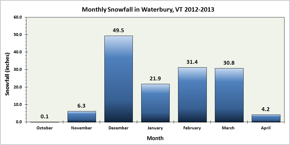
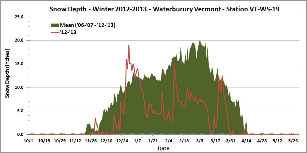


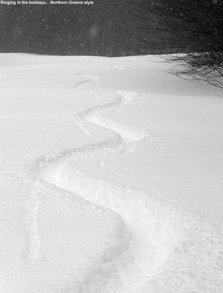
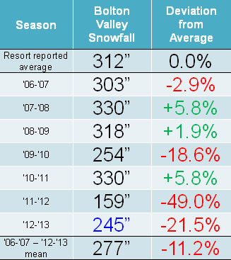
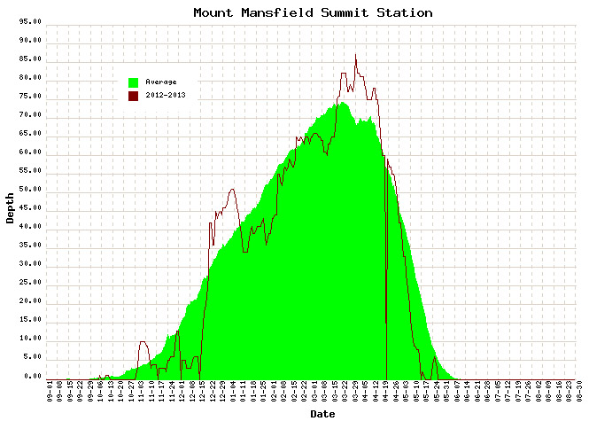
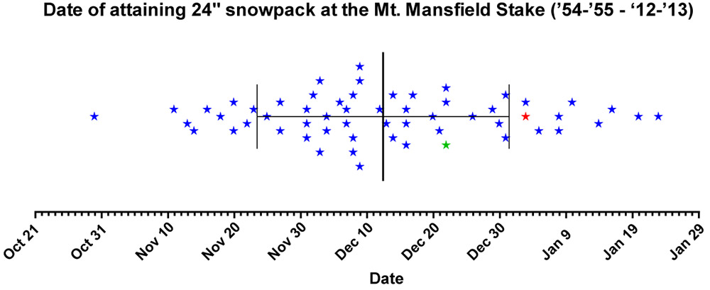
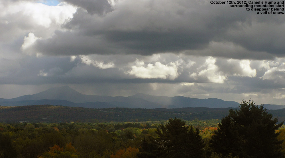
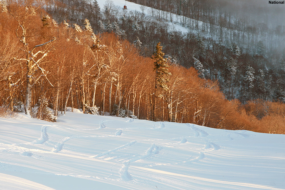
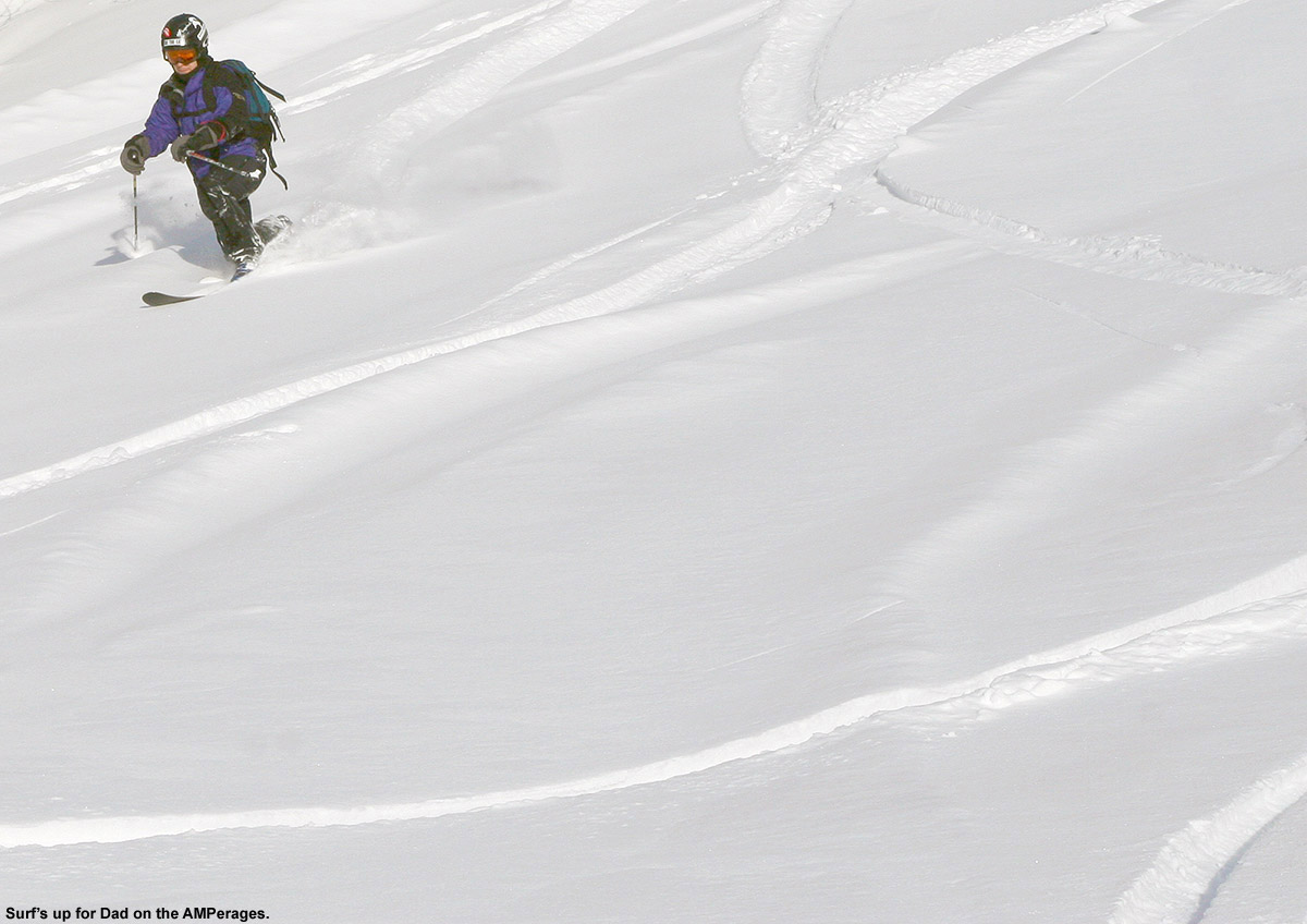
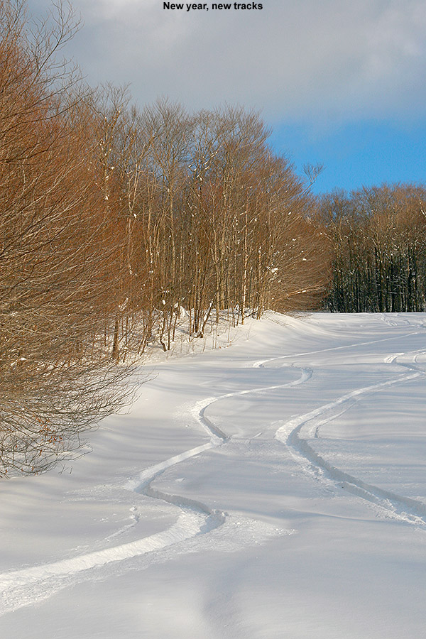
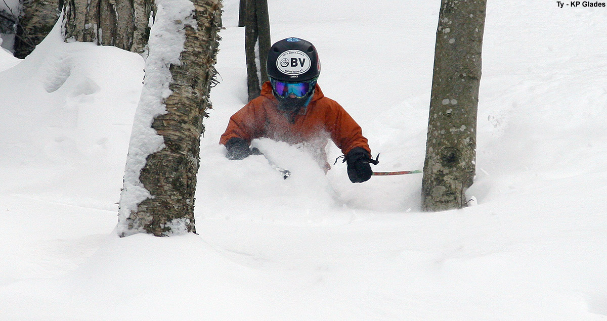
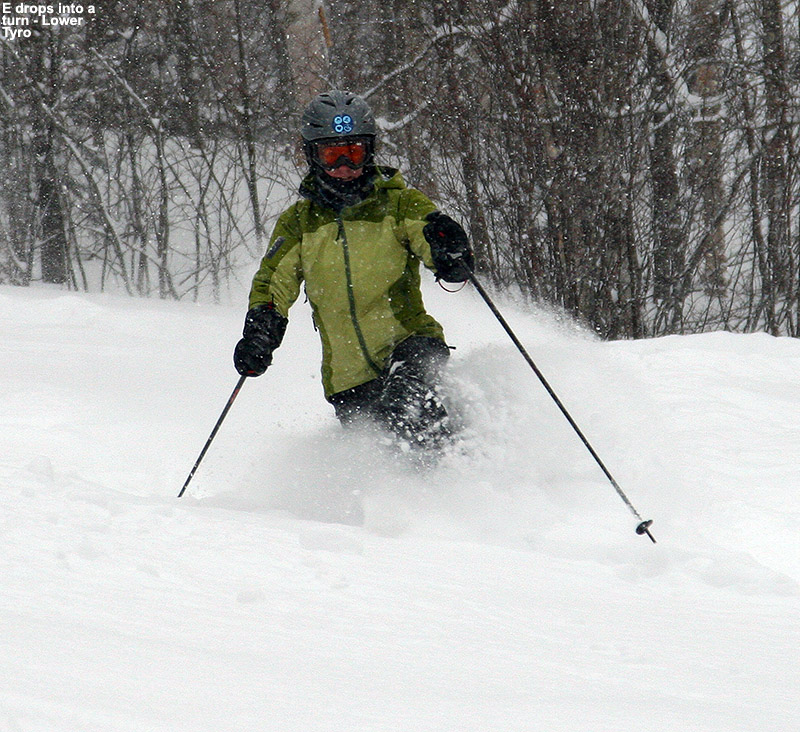
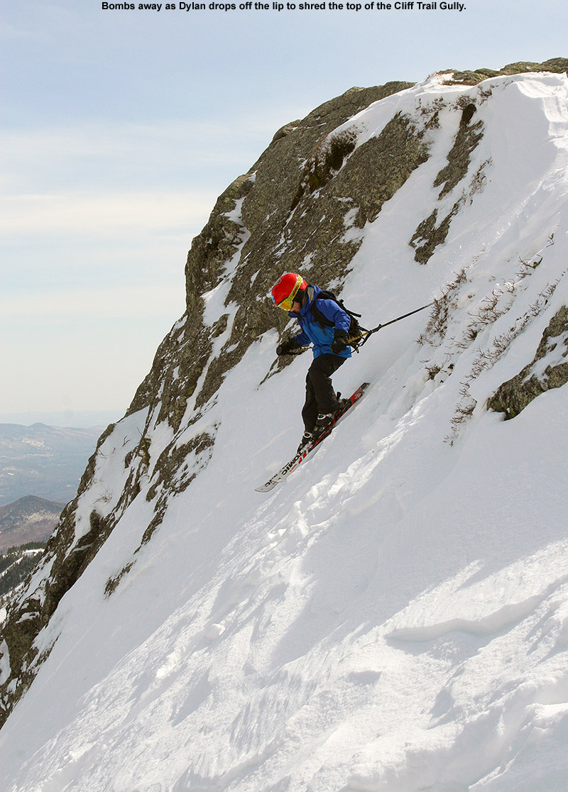
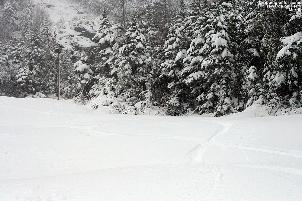


")


